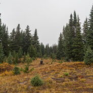
This marvelous example of Rocky Mountain vistas starts, oddly enough, directly beside Interstate-70 at Colorado’s 10,585′ Vail Pass. The trail winds through forest and meadow, then climbs steeply above treeline to Uneva Ridge, 1,500 feet above. Along the way you will enjoy breathtaking views of four distinct mountain ranges as you pass into Eagles Nest Wilderness, and experience the high mountain air. If you still have some energy left, you can continue to either Uneva Pass, or Uneva Peak, another solid 500 feet higher. Regardless...
read moreHighway 4, west out of Leadville, CO offers a driving adventure that takes you past lakes, among a various assortment of summer wildflowers, and over a high mountain pass that tops out just short of 12,000 feet. I needed the drive rather than hiking the first day after recovering from a newly discovered adult-onset allergy to cashew nuts. The annual visit with my brother Dave started with an overnight emergency room experience. The good folks at Vail Valley Medical got me back on my feet though, and by the next day I was ready to go...
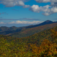
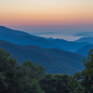
read moreI like to do most of my summertime hiking in the high country to avoid the heat, and the bugs. It’s like getting extra, added months of spring. So when the first week of summer rolled around, I thought of that section of Pisgah National Forest that lies between Shining Rock and Middle Prong Wildernesses, surrounded by the Blue Ridge Parkway, Hwy 215, and Black Balsam Road. You can make a very nice 9-mile loop out of the Flat Laurel Creek Trail and the Mountains to Sea Trail, staying between 5,000-6,000 feet elevation the whole way....
read moreHo. Hum. Just another day at Roan Highlands. Now, obviously I’m being facetious. Roan Highlands is probably my favorite place to go in all of Western North Carolina, especially in mid-June when it is catawba rhododendron and flame azalea time. It’s exciting to hike on the iconic Appalachian Trail, the views of Tennessee and North Carolina on either side of the ridge are among the best you will find anywhere, and the flowers are, to put it mildly, simply gorgeous. This visit was on June 15, 2017. I arrived at 6:45AM with bad...
read moreRemote. This little slice of Nantahala National Forest is truly far from anything. Once you are a mile into the woods from the trailhead, there is next to no evidence of human activity. It’s hard to know how many folks come here to hike, but there aren’t many boot prints in the mud. There are, however, plenty of deer tracks… and wildflowers. Wow, are there wildflowers. From Sugar Creek Gap there are great views of the Blue Ridge to both the north and the south, then the hiking is through a dense forest comprised of mostly...
read moreBaxter Creek Trail has a well-earned reputation as one of the hardest hikes in all of Great Smoky Mountains National Park. Starting at the Big Creek picnic area near Waterville, NC it climbs more than 4,000 feet over 6.2 miles, roughly 700 feet/mile. That will get your attention. Look for stunning forest scenes, waterways that keep the forest green, seasonal wildflowers, and sweeping vistas from the summit of 5,842′ Mt. Sterling. Take plenty of food and water, and energy, because you will definitely need it. But also take your time and...
read moreWhen looking for some WNC high country scenery and perhaps refreshing cool air on a warm day, one of the first destinations I think of is the Black Balsam area at milepost 420 on the Blue Ridge Parkway. There are half a dozen mountains here that stand above 6,000 feet, with encompassing 360° views from their treeless summits. This land that lies between the Shining Rock and Middle Prong Wildernesses is pierced by the Art Loeb Trail, a favorite of anyone who visits the Pisgah Ranger District. My hiking pal Ken and I have walked this region...
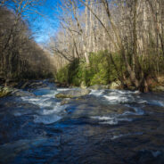
read morePerhaps the finest creek side trail in all of Great Smoky Mountains National Park, Middle Prong Trail actually follows Lynn Camp Prong. Lynn Camp and Thunderhead Prong join to form Middle Prong just below the trailhead. You will walk alongside Lynn Camp Prong for the entire length of this hike, passing dozens of swift cascades and two exciting waterfalls. Look for a wide variety of wildflowers in spring and a splendid leaf peeping show in autumn. I visited Tremont on Wednesday, May 10, 2017 beginning at 7:30AM and ending about 10:00AM. My...
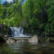
read moreOne of the most popular hiking trails in Great Smoky Mountains National Park, Abrams Falls at the west end of Cades Cove has the full Smokies package all in one. Here you can find rich, bountiful forest with a floor of colorful spring wildflowers, a rushing creek that provides refreshing nourishment for all the plants and wildlife, good exercise as you climb up and over Arbutus Ridge to enjoy majestic mountain views, the stunning reward of a picturesque plunge waterfall, and a touch of Smokies history from the Cherokee and settlers who called...
read morePisgah National Forest comes alive in early May. It seems as though the greening happens almost overnight. Daniel Ridge Loop Trail is an amazing place to experience the changing of the forest from its sleepy, drab brown hues to the vibrant verdant that fills the senses. The creek along the pathway is the most picturesque in Pisgah Ranger District in my opinion, and the varieties of hardwood trees, wildflowers, and understory vegetation will keep you enthralled for hours. My brother Dave and I hiked the loop trail on May 2, 2017 with little in...
read moreEvery April I like to make a two-day trip to the Tennessee side of Great Smoky Mountains National Park. I usually stay overnight at the Cades Cove Campground. It is a glorious time in the Smokies. The spring ephemeral wildflowers are busting out all over. The weather is warming and the days are getting longer. The rivers, creeks and streams are usually full of cool, refreshing water that comes from the snow melt high above. And so it was that I loaded up my Subaru to head to the Tennessee Smokies on April 13th. I just forgot to consider one...
read moreYellowstone Prong has some of the most rugged terrain in all of the Pisgah Ranger District. Paralleling the Blue Ridge Parkway from Looking Glass Rock Overlook at milepost 417, and climbing the drainage from Skinny Dip Falls to Yellowstone Falls, this hike in, along, and above Yellowstone Prong may be the most challenging mile I have undertaken. You will scramble over car-size boulders in the prong. You will whack your way through rhododendron thickets and climb over massive hemlock and oak deadfall. Best of all, you will enjoy incredible...
read moreSome of the earliest wildflowers of the new season can be found on the Green River Game Lands near the North and South Carolina border. The elevation isn’t quite as high here as it is in most of the mountains of WNC, so the flowers get a little bit of a head start. Look for chickweed, rue anenome, wake robin trillium, blue and Canadian violets, robins plantain and lots of bloodroot. Several more varieties will follow in succeeding weeks, but these are the first to pop out and display their finery. I hiked the Little Bradley Trail the...
read moreDeep Creek is one of many popular recreation areas found in Great Smoky Mountains National Park. Camping and picnicking are in abundance, as well as plenty of waterways for fishing and tubing. The assorted hiking trails also make it a fun destination for you and me. This hike, a combination of two different small loop trails affords the opportunity to visit the three famous Deep Creek waterfalls, to explore the nearby forest, and to follow the refreshing streams that flow through the area. Ken and I visited Deep Creek on Tuesday, February 28,...
read moreThe Shut-in Ridge Trail and the Mountains to Sea Trail are one as they traverse the Blue Ridge from the North Carolina Arboretum to Mt. Pisgah. Along the way, there are several jumping on and off points where you can access this trail from the Blue Ridge Parkway, enabling short day hikes. One of these short sub-sections is along Bent Creek Gap Road at BRP milepost 400. From there it’s a steep climb of 1.4 miles to an old fire tower location on Ferrin Knob. Ken and I visited this little corner of the Blue Ridge Parkway on Tuesday,...
read moreElkmont is a nice area of the Smokies to visit in winter. It’s quiet, historic, alive with waterways, and offers views of the surrounding mountains through the leafless trees. Little River is beautiful as always, the climb up and over Cucumber Gap is invigorating, and the timeless cottages of Daisy Town along Jakes Creek harken back to a simpler time in the mountains. Combine them all on this delightful loop hike. I visited Elkmont on Wednesday, January 25, 2017 beginning at 9:30AM and ending about 12:45PM. My plan was to take Little...
read moreCataloochee Valley in the Smokies is of course most popular during the green seasons. People come from far and wide to experience the wildflowers in Spring, the myriad of hiking trails in Summer, and the exciting elk rut and colorful foliage in Fall. But Winter too has its appeal. Perhaps the best reason to go to Cataloochee in winter is the solitude. The crowds are considerably smaller. The wildlife is still there. The trails are just as inviting. The views are every bit as scenic. The creeks are refreshing as always. Sure, it isn’t...
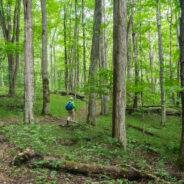
read moreThe first time I went to Great Smoky Mountains National Park more than 15 years ago I knew it was someplace special. But it took me nearly 10 more years before I ever set foot on one of her trails. Work kept me busy and I had different recreational interests, but when I got serious about hiking around 2008, you couldn’t hold me back. Most of my early hikes were closer to home in Pisgah National Forest, but when I made my first Smokies hike, climbing the Rich Mountain Loop above Cades Cove, I was hooked. I’ve been at it ever since....
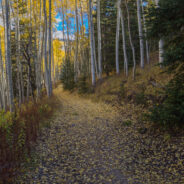
read moreThe final day of our recent trip to New Mexico, my brother Dave and I returned to his home in Colorado. Along the way we stopped for some sight seeing in Los Alamos, NM, Pagosa Springs, CO and near Leadville, CO. When we originally left Colorado a few days before, the weather had been summer-like, and we had enjoyed the turning of the aspen trees to their brilliant autumn gold. Once we crossed back into Colorado from the south it became evident some different weather had arrived while we were gone. There was an October snowfall in the...
read moreStarting at the former site of George Vanderbilt’s Buck Spring hunting lodge near Mt. Pisgah, this hike crosses the summit of Little Bald Mountain before dropping down the watershed to Pilot Rock, one of the many plutons found within the Pisgah Ranger District. The high country is home to thickets of mountain laurel and rhododendron, while various maples, oaks and pines line the trail as you near Pilot Rock. Ken and I took this picturesque trek on Wednesday, October 19, 2016 beginning at 9:30AM and ending about 1:45PM. Our plan was to...
read moreValles Caldera is a 13.7-mile wide volcanic bowl in the Jemez Mountains of northern New Mexico near Los Alamos. About 1.25 million years ago, a spectacular volcanic eruption created this circular depression now known as the Valles Caldera. The Valles Caldera Preservation Act of 2000, signed by President Clinton, created the National Preserve. The preserve is known for its huge mountain meadows, abundant wildlife, and meandering streams. The area also preserves the homeland of ancestral native peoples and embraces a rich ranching history. The...
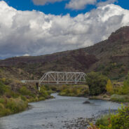
read moreThe Río Grande del Norte National Monument is comprised of rugged, wide open plains at an average elevation of 7,000 feet, dotted by volcanic cones, and cut by steep canyons with rivers tucked away in their depths. The Río Grande River carves an 800 foot deep gorge through layers of volcanic basalt flows and ash. Among the volcanic cones in the Monument, Ute Mountain is the highest, reaching to 10,093 feet. This area has attracted human activity since prehistoric times. Evidence of ancient use is found throughout the area in the form of...
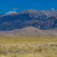
read moreGreat Sand Dunes National Park and Preserve protects the tallest sand dunes in North America, and a whole lot more. From the San Luis Valley floor to the crest of the 13,000 foot peaks in the Sangre de Cristo Mountains — the park and preserve contains ecosystems ranging from sand sheet to dunes to tundra — each supporting specially adapted plant, animal and insect life. Days are typically sunny, even in winter, and nights offer skies so dark you can see the Milky Way. Recreational opportunities include backpacking and hiking, car...
read moreThere aren’t many places in Western North Carolina better for Autumn leaf peeping than the Blue Ridge Parkway. On Monday, October 17, 2016 I set out to demonstrate that by taking a little tour between mileposts 410 and 420. But first I had to get there. I went up the Pisgah Ridge on Scenic Hwy 276, passing the Cradle of Forestry along the way. I arrived at the Cold Mountain Overlook once on the Parkway, then headed to Pounding Mill Overlook to take care of one of my volunteer jobs. I pick up trash at this overlook on a regular basis....
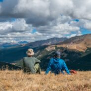
read moreThere’s a reason they call it Summit County. An old mining road climbs from Hoosier Pass above 12,000 feet and is surrounded by several of Colorado’s famous fourteeners. The first half of the road meanders through a spruce and fir forest with occasional views of the massive mountains that envelop the region. The rest of the way is above treeline, offering unobstructed viewing of giants Mt. Bross, Mt. Lincoln, Mt. Silverheels and Quandary Peak. The north side of the ridge also has long distance vistas of more fourteeners, several...
read moreFog and low-lying mist is very common in the Southern Appalachians. It is a product of the rainforest effect. Fog is highly unusual in the Rocky Mountains, but that’s what greeted Dave and I as we hit the trailhead to climb Shrine Ridge. It was somewhat of a dreary, forlorn scene as we walked from mountain bog to spruce forest to high meadow on our way to the ridgeline. Shrine Ridge has wide open vistas of three mountain ranges including Sawatch, Tenmile, and Gore… but not on this day. We visited Shrine Ridge Trail on Friday,...
read moreThe U.S. Forest Service has done a nice job of building trails up the watersheds that drain into the Town of Vail. Included among these is Spraddle Creek, located across I-70 from Vail Village. The reward at the top of the ridge is a mountain meadow that overlooks Vail, Beaver Creek ski mountain, and the Holy Cross Wilderness far, far away. Hike in late September for an extra treat of peak golden aspen color. My brother Dave and I enjoyed Spraddle Creek Trail on Thursday, September 29, 2016 beginning at 9:00AM and ending about 1:30PM. Our...
read moreThis remote corner of the Smokies isn’t easy to get to, but your efforts will be rewarded with solitude, quiet, peaceful 2nd growth forest, and a pensive wandering. The Cherokee lived on one side of the ridge. The Cataloochee settlers on the other. They met in the middle to graze their cattle on “The Ledge” between the two. The bald knobs are reforested now, but I found myself thinking about what it was like to be here a century ago. A little warning is in order: you are in for a longish drive on twisty gravel road both...
read moreThe forest north of Cataloochee Valley in the Mt. Sterling watershed has recovered nicely from logging activities a century ago. It is dense, rich and diverse… a verdant testimony to Nature’s ability to reinvigorate herself. This hike starts at the north end of Little Cataloochee on Mt. Sterling Road and meets Long Bunk Trail a mile later. Long Bunk is a near 4-mile path that winds through cove and hardwood forest until it meets the Mt. Sterling Trail. Along the way you have an appointment with historic artifacts, and with dynamic...
read more I am Jeff Clark, founder of Internet Brothers, producer of this blog, and passionate about hiking. I live in Western NC near the Blue Ridge and Great Smoky Mountains. Pisgah and Nantahala National Forests are just out my door, so the content will focus on these areas, but let me know what you would like to see on the site.


Copyright © 2011-2023 Internet Brothers. All Rights Reserved. ISSN 2324-6057
Designed by Elegant Themes | Powered by Wordpress | Logo by Design Aspirations