
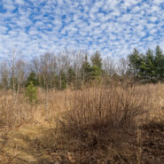
Tucked away in the northeastern corner of DuPont State Forest in Western North Carolina, Stone Mountain is the highest point in the state forest at 3,620 feet. Appropriately named for the exposed granite slab that traverses its summit, Stone Mountain offers a near 270° view of the surrounding terrain to winter hikers. Since the first time I went, nearly 12 years ago,...
Learn More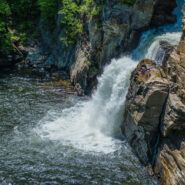
Located at milepost 316.5 along the Blue Ridge Parkway, Linville Falls moves in several distinct steps, beginning in a twin set of upper falls, passing through a small twisty gorge, and culminating in a high-volume 45-foot plunge. The Linville River flows from its headwaters high on the steep slopes of Grandfather Mountain and cascades through these falls as it begins a...
Learn More
Sure, there are lots and lots of wildflowers in April at Whiteoak Sink and on the hillside at the Townsend Y to make this hike seriously entertaining. But there is a lot more to the Schoolhouse Gap/Chestnut Top combination hike than abundant spring flowers. The views into Townsend from the Chestnut Top ridge are notable, and the forest that surrounds you throughout is...
Learn More
With the perpetual crowd at The Sinks location in the Smokies, it was surprising to me that hardly anyone hikes this trail that starts at the popular waterfall along Little River Road. Another surprise was the abundance of spring ephemeral wildflowers found along the trail. I counted more than a dozen varieties, and plenty of each. Once you reach Meigs Creek, it’s...
Learn More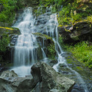
The Cosby section of the Smokies park is mostly known for its long, arduous treks to high country destinations like Mt. Cammerer and Inadu Knob. But there is another trail there that is more moderate in difficulty. A good day hike on Gabes Mountain Trail is the 4-mile round trip to Hen Wallow Falls, a 90-foot, multi-tiered cascade. This is cool, dense forest, some of it...
Learn More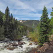
This trail climbs from East Vail into Eagles Nest Wilderness alongside Gore Creek. There are some short steep sections that wind through meadows and aspen groves which change to spruce-fir stands as the elevation increases. Also look for a wide variety of wildflowers in season. Particularly during spring runoff, Gore Creek rages down the drainage with its series of fast...
Learn More
You can’t really tell from the overlook, but there’s a lot to like down in Swamp Canyon. For one, this is part of Bryce Canyon Wilderness, so it is definitely less crowded than the majority of the national park. There are great views of Wightman Bench and Swamp Canyon Butte from down in the canyon. Wildflowers and wildlife are abundant during the green...
Learn More
Golden hour is special for any place with picturesque scenic beauty, especially if you also happen to like photography. There aren’t many places more stunning during the golden hour — that time right after sunrise and right before sunset — than Bryce Canyon. There are even viewpoints named for these wonderful times… Sunrise Point and Sunset Point....
Learn More
I think of the Hell Canyon Trail in Black Hills National Forest, South Dakota as two hikes. There’s the stroll through the canyon with lush trees and bushes and a wide assortment of colorful wildflowers. Then, there’s the path along the canyon rim that exposes the devastation of the 2000 Jasper Fire, the largest in Black Hills history. The undergrowth is...
Learn More
This hike in the heart of Wind Cave National Park combines two trails to make a 5-mile loop, and the two couldn’t be any more different. Centennial Trail takes you through lush meadows, and a rocky canyon lined with pine, while Lookout Point Trail experiences the wide open spaces of the South Dakotan prairie. Centennial follows the path of Beaver Creek through the...
Learn More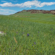
Located in the remote northern corner of Wind Cave National Park, Boland Ridge Trail crosses the wide open prairie, then a series of ridge climbs offer panoramic views of the Black Hills, the Red Valley, and the western South Dakota plains beyond. Because of the isolated nature, elk and bison are often seen along this trail. In fact, we had to cut this one about a mile...
Learn More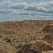
There are three short trails that share the same trailhead on the far eastern section of Badlands National Park. The Window and Door Trails are boardwalks that explore the spires and buttes of the Badlands Wall. Notch Trail passes through the Wall and offers a great view of the White River Valley. There is even a fun rope ladder that takes you to the canyon rim as you...
Learn More
This is one of my new favorite Spring wildflower hikes in the Smokies. The flowers are brilliant along both the Bradley Fork and Cabin Flats Trails. The Smokemont region of the Smokies is one of the most convenient, located just a short few miles northwest of the Oconaluftee Visitor Center off Hwy 441. It is four miles up Bradley Fork to Cabin Flats Trail, then another...
Learn More
Another of the fun and exciting South Carolina state parks that line the Cherokee Foothills Scenic Highway, Keowee Toxaway offers two hiking trails that take visitors over a natural bridge and through the foothills of the Blue Ridge Mountains, land once traveled by Cherokee Indians. Much of the trail follows the shore of Lake Keowee through the healthy oak/hickory forest...
Learn More
One of the more enjoyable trails I have hiked recently in the Smokies, Old Sugarlands follows West Prong of Little Pigeon River for a mile and a half, then turns to the east and ascends the western flank of the LeConte Ridge another 2.4 miles to a pastoral setting known as Cherokee Orchard. This trail receives surprisingly little use despite being surrounded by a hub of...
Learn More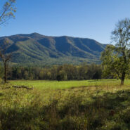
This was the first trail I hiked in Great Smoky Mountains National Park. It was back in 2008 or so, well before I started this website. So I thought it must be time, nearly 10 years later, to do it again and tell you about it. Rich Mountain Loop is a combination of three trails: Rich Mountain Loop Trail, Indian Grave Gap Trail, and Crooked Arm Ridge Trail. Most people...
Learn More
This trail follows the McCullough Creek drainage up the gulch beneath the massive summit of 14,225′ Quandary Peak. It starts on an old mining road south of Breckenridge, CO, then changes to single track trail as it climbs the gulch. You’ll pass through pine and fir forest, get splashed by White Falls, marvel at the colorful granite, and count the variety of...
Learn More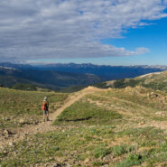
The easier of the trails at Loveland Pass, West Ridge surrounds two sides of the bowl that makes up the Loveland area and the I-70 corridor over the Continental Divide. Still, at 11,990 feet, this is no piece of cake for folks like me who are used to mountains no more than half the elevation. Several ski slopes are visible from the ridge. Look too for cute rodents to...
Learn More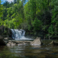
One of the most popular hiking trails in Great Smoky Mountains National Park, Abrams Falls at the west end of Cades Cove has the full Smokies package all in one. Here you can find rich, bountiful forest with a floor of colorful spring wildflowers, a rushing creek that provides refreshing nourishment for all the plants and wildlife, good exercise as you climb up and over...
Learn More
Deep Creek is one of many popular recreation areas found in Great Smoky Mountains National Park. Camping and picnicking are in abundance, as well as plenty of waterways for fishing and tubing. The assorted hiking trails also make it a fun destination for you and me. This hike, a combination of two different small loop trails affords the opportunity to visit the three...
Learn More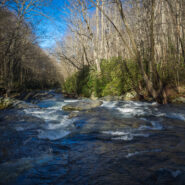
Elkmont is a nice area of the Smokies to visit in winter. It’s quiet, historic, alive with waterways, and offers views of the surrounding mountains through the leafless trees. Little River is beautiful as always, the climb up and over Cucumber Gap is invigorating, and the timeless cottages of Daisy Town along Jakes Creek harken back to a simpler time in the...
Learn More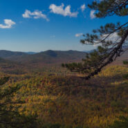
Starting at the former site of George Vanderbilt’s Buck Spring hunting lodge near Mt. Pisgah, this hike crosses the summit of Little Bald Mountain before dropping down the watershed to Pilot Rock, one of the many plutons found within the Pisgah Ranger District. The high country is home to thickets of mountain laurel and rhododendron, while various maples, oaks and...
Learn More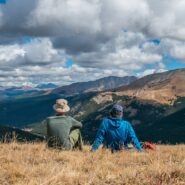
There’s a reason they call it Summit County. An old mining road climbs from Hoosier Pass above 12,000 feet and is surrounded by several of Colorado’s famous fourteeners. The first half of the road meanders through a spruce and fir forest with occasional views of the massive mountains that envelop the region. The rest of the way is above treeline, offering...
Learn More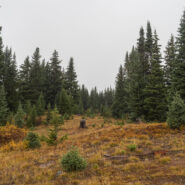
Fog and low-lying mist is very common in the Southern Appalachians. It is a product of the rainforest effect. Fog is highly unusual in the Rocky Mountains, but that’s what greeted Dave and I as we hit the trailhead to climb Shrine Ridge. It was somewhat of a dreary, forlorn scene as we walked from mountain bog to spruce forest to high meadow on our way to the...
Learn More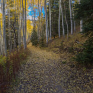
The U.S. Forest Service has done a nice job of building trails up the watersheds that drain into the Town of Vail. Included among these is Spraddle Creek, located across I-70 from Vail Village. The reward at the top of the ridge is a mountain meadow that overlooks Vail, Beaver Creek ski mountain, and the Holy Cross Wilderness far, far away. Hike in late September for an...
Learn More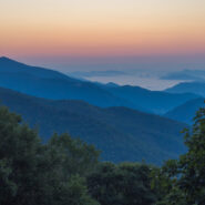
This remote corner of the Smokies isn’t easy to get to, but your efforts will be rewarded with solitude, quiet, peaceful 2nd growth forest, and a pensive wandering. The Cherokee lived on one side of the ridge. The Cataloochee settlers on the other. They met in the middle to graze their cattle on “The Ledge” between the two. The bald knobs are reforested...
Learn More
The forest north of Cataloochee Valley in the Mt. Sterling watershed has recovered nicely from logging activities a century ago. It is dense, rich and diverse… a verdant testimony to Nature’s ability to reinvigorate herself. This hike starts at the north end of Little Cataloochee on Mt. Sterling Road and meets Long Bunk Trail a mile later. Long Bunk is a near...
Learn More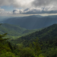
Love the high country in summer. It’s like getting an extra month of spring. For much of its length through the Western North Carolina mountains, the Mountains to Sea Trail parallels the Blue Ridge Parkway. There is an area near mile marker 434 on the Parkway, beneath Old Bald, where the MST winds through mixed forest and high mountain meadows teeming with...
Learn More I am Jeff Clark, founder of Internet Brothers, producer of this blog, and passionate about hiking. I live in Western NC near the Blue Ridge and Great Smoky Mountains. Pisgah and Nantahala National Forests are just out my door, so the content will focus on these areas, but let me know what you would like to see on the site.


Copyright © 2011-2023 Internet Brothers. All Rights Reserved. ISSN 2324-6057
Designed by Elegant Themes | Powered by Wordpress | Logo by Design Aspirations