
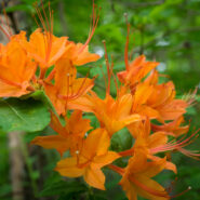
Remote. This little slice of Nantahala National Forest is truly far from anything. Once you are a mile into the woods from the trailhead, there is next to no evidence of human activity. It’s hard to know how many folks come here to hike, but there aren’t many boot prints in the mud. There are, however, plenty of deer tracks… and wildflowers. Wow, are...
Learn More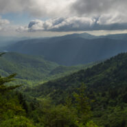
Love the high country in summer. It’s like getting an extra month of spring. For much of its length through the Western North Carolina mountains, the Mountains to Sea Trail parallels the Blue Ridge Parkway. There is an area near mile marker 434 on the Parkway, beneath Old Bald, where the MST winds through mixed forest and high mountain meadows teeming with...
Learn More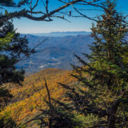
Sometimes things just don’t go exactly as planned. But making the most of what’s available is what sets hiking apart. Everything doesn’t have to go perfectly to still enjoy the day. Such was the case with this hike across the Plott Balsams mountain range from Waterrock Knob on the Blue Ridge Parkway. You’re in rarefied air here, with the entire...
Learn More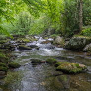
Joyce Kilmer-Slickrock Wilderness straddles the North Carolina / Tennessee line near the southern borders of the states, with about 75% of its 17,000 acres contained in NC. Six trailheads provide access to more than 60 miles of trail within the designated wilderness, which typically follow ridge tops or drop into the shady drainages. Perhaps the most atypical trail...
Learn More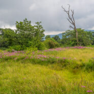
Deep in the remote southwestern corner of North Carolina where the scenic Cherohala Skyway climbs to meet Tennessee at Beech Gap, the Bob Bald Connector Trail (54A) climbs a ridge through Nantahala National Forest to Bob Stratton Bald. One of the lush mountaintop meadows the Southern Appalachians are known for, Bob Bald as it is called, straddles a boundary between...
Learn More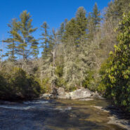
Even though Devils Elbow is a mountain summit, the highlights of the Devils Elbow Trail in Panthertown are the myriad of waterfalls on the Tuckasegee River. The river forms at the confluence of Panthertown and Greenland Creeks, then takes a wild ride over several falls on its way eventually to Fontana Lake in the Great Smoky Mountains. Most of this hike is on maintained...
Learn More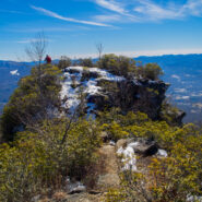
Pinnacle Park is an 1,100 acre tract of land owned by the town of Sylva in Jackson County, NC that was previously used as the community watershed. In 1991 it was leased to the Pinnacle Park Foundation for developing hiking trails that pass by streams, waterfalls, and beautiful long distance vistas. The Pinnacle, where the park got its name, is a large rocky outcropping...
Learn More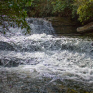
Panthertown Valley in Nantahala National Forest is known for its stunning mountaintop vistas, but also for a numerous and varied assortment of waterfalls that run the gamut from slides, to cascades, to ledge and plunge. Six of those falls are along Greenland Creek, including the feature cascade Greenland Creek Falls. Beyond this tall waterfall, the Greenland Creek Trail...
Learn More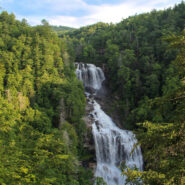
Transylvania County, North Carolina is known as “Land of Waterfalls” for good reason, as there are 250 unique cascades within a short drive of each other. Upper Whitewater Falls on the Whitewater River south of Sapphire is perhaps the most spectacular. There are two distinct overlooks of the 411 foot plunge taken by the river on its path to Lake Jocassee....
Learn More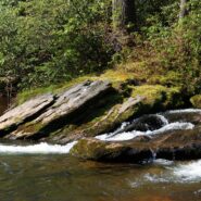
Designated a National Wild and Scenic River, the Chattooga River’s headwaters are in North Carolina, but it stretches into Georgia and South Carolina as well. In fact, at one point known as Ellicott Rock, it marks the common tri-boundary of all three states. There are more than 50 miles of trails along the Chattooga River but this four-mile stretch just south of...
Learn More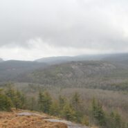
Situated in the far northern reaches of the Panthertown Trail System in Nantahala National Forest, Turkey Knob and Blackrock Mountain offer long distance views of the more well known features of Panthertown Valley. From more than 4000 feet elevation, there are splendid views of Little and Big Green Mountains and The Great Wall. The full expanse of Mac’s Gap lays on...
Learn More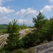
This is an extension of the trail report about the Panthertown Trail System in Nantahala National Forest from a previous post. When we explored Panthertown last November, we knew very little about it and kind of fumbled our way along the myriad of trails. Since, we have studied the trail system map and had a plan that included going to the top of Big Green Mountain, a...
Learn More
Panthertown Valley lies in Nantahala National Forest near Cashiers and Lake Toxaway, North Carolina. The Forest Service, along with the Friends of Panthertown, have created a trail system in combination with old logging roads that lead to waterfalls, cliffs, bogs, deep forest and spectacular overlooks of the surrounding valley. Panthertown has been designated a Blue...
Learn More I am Jeff Clark, founder of Internet Brothers, producer of this blog, and passionate about hiking. I live in Western NC near the Blue Ridge and Great Smoky Mountains. Pisgah and Nantahala National Forests are just out my door, so the content will focus on these areas, but let me know what you would like to see on the site.


Copyright © 2011-2023 Internet Brothers. All Rights Reserved. ISSN 2324-6057
Designed by Elegant Themes | Powered by Wordpress | Logo by Design Aspirations