
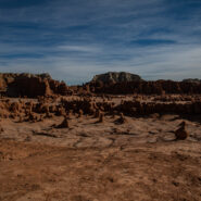
Believed to be evil, greedy, or mischievous, goblins are mythical creatures who bring trouble to humans, appearing in the folklore of multiple European cultures first attested in stories from the Middle Ages. Goblin Valley State Park, off Highway 24 at the San Rafael Swell in Utah includes an area where soft sandstone has eroded into interesting shapes, somewhat...
Learn More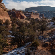
Located in the high desert canyon country of western Colorado, McInnis Canyons National Conservation Area consists of approximately 123,430 acres of BLM-administered land near Fruita, Colorado. Originally known as Colorado Canyons National Conservation Area, the NCA was established by Congress on October 24, 2000. Internationally important fossils have been uncovered...
Learn More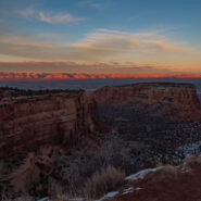
One of these days you are likely to look up and see that Colorado National Monument, along with McInnis Canyons National Conservation Area, has become a full-fledged national park. The stunning scenery certainly qualifies. With the acreage included in MCNCA, the size is there as well. The combination of NPS units offers a myriad of front country hiking trails and...
Learn More
Golden hour is special for any place with picturesque scenic beauty, especially if you also happen to like photography. There aren’t many places more stunning during the golden hour — that time right after sunrise and right before sunset — than Bryce Canyon. There are even viewpoints named for these wonderful times… Sunrise Point and Sunset Point....
Learn More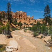
Arriving at Bryce Canyon mid-afternoon, Dave and I headed for the short Mossy Cave Trail to get our feet wet among the majestic hoodoos. This trail actually begins outside the park at the far northern reaches, then enters the park boundary on foot. The trail is a streamside walk up to a mossy overhang and small waterfall. Mossy Cave isn’t a cavern, but is a grotto,...
Learn More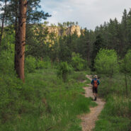
I think of the Hell Canyon Trail in Black Hills National Forest, South Dakota as two hikes. There’s the stroll through the canyon with lush trees and bushes and a wide assortment of colorful wildflowers. Then, there’s the path along the canyon rim that exposes the devastation of the 2000 Jasper Fire, the largest in Black Hills history. The undergrowth is...
Learn More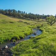
This hike in the heart of Wind Cave National Park combines two trails to make a 5-mile loop, and the two couldn’t be any more different. Centennial Trail takes you through lush meadows, and a rocky canyon lined with pine, while Lookout Point Trail experiences the wide open spaces of the South Dakotan prairie. Centennial follows the path of Beaver Creek through the...
Learn More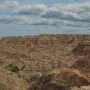
There are three short trails that share the same trailhead on the far eastern section of Badlands National Park. The Window and Door Trails are boardwalks that explore the spires and buttes of the Badlands Wall. Notch Trail passes through the Wall and offers a great view of the White River Valley. There is even a fun rope ladder that takes you to the canyon rim as you...
Learn More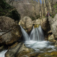
Yellowstone Prong has some of the most rugged terrain in all of the Pisgah Ranger District. Paralleling the Blue Ridge Parkway from Looking Glass Rock Overlook at milepost 417, and climbing the drainage from Skinny Dip Falls to Yellowstone Falls, this hike in, along, and above Yellowstone Prong may be the most challenging mile I have undertaken. You will scramble over...
Learn More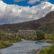
The Río Grande del Norte National Monument is comprised of rugged, wide open plains at an average elevation of 7,000 feet, dotted by volcanic cones, and cut by steep canyons with rivers tucked away in their depths. The Río Grande River carves an 800 foot deep gorge through layers of volcanic basalt flows and ash. Among the volcanic cones in the Monument, Ute Mountain is...
Learn More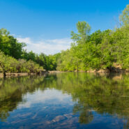
Established in 1972, Buffalo National River flows freely for 135 miles in Arkansas and is one of the few remaining undammed rivers in the lower 48 states. Once you arrive, prepare to journey from running rapids to quiet pools while surrounded by massive bluffs as you cruise through the Ozark Mountains. At a large curve in the river known as Horseshoe Bend, you can access...
Learn More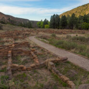
The Puebloan people have lived in the American Southwest for many centuries. Archaeologists think they are descended from groups of hunters and gatherers who came to the region over 10,000 years ago. In the area that is now Bandelier National Monument, in Northern New Mexico, the villages of Tyuonyi and Tsankawi and their adjacent cliff dwellings appeared in the 13th...
Learn More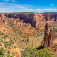
The labyrinth called Canyon de Chelly (pronounced d’SHAY) comprises several canyons that include Canyon de Chelly, Monument Canyon and Canyon del Muerto. At the mouth of the canyons near the tribal town of Chinle, in northeastern Arizona, the rock walls are only 30 feet high. Deeper in, the bright red sandstone bluffs rise dramatically to stand more than a thousand...
Learn More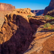
Island in the Sky is a thousand foot high mesa in the isthmus between the Green and Colorado Rivers that forms one of Canyonlands National Park’s four distinct districts. There is excellent hiking on each side of the mesa, including this trail on the west side that circumnavigates Upheaval Dome. Once thought to be a collapsed salt dome, new geologic evidence...
Learn More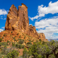
Most folks who visit Colorado National Monument view its red sandstone landmarks from Rim Rock Drive and its many overlooks. It’s convenient for peering deep into the canyons. However, like most places of interest, getting out of your car and putting your boots on the trail will give you an up-close-and-personal encounter with iconic features like Independence...
Learn More
Venturing more into the central part of Tennessee to the Cumberland Plateau has been a goal of mine for some time. The name “Walls of Jericho” kept cropping up, so that clinched the destination. So what is this hike with the biblical name? The place known as the Walls of Jericho is a narrow canyon, about a half-mile long, with 200-foot-high vertical limestone...
Learn More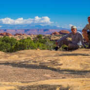
The Needles District forms the southeast corner of Canyonlands National Park and was named for the colorful spires of Cedar Mesa Sandstone that dominate the area. The district’s extensive trail system provides many opportunities for overnight trips or long day hikes including this one around, over and through Elephant Canyon. This 10-mile loop will take you up...
Learn More
The canyon and mesa country north of the San Juan River in the four corners region holds many archaelogical sites where ancestors of today’s Pueblo Indian tribes lived. Round, square, and D-shaped towers grouped at canyon heads most vividly mark once thriving communities. Many dwellings stood right on the canyon rim, and some structures were built atop isolated or...
Learn More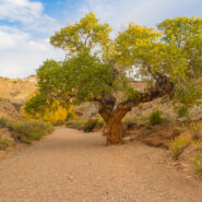
The San Rafael Swell consists of a giant dome-shaped anticline of sandstone, shale, and limestone that houses many of the classic slot canyons that Southern Utah is known for. Included among them is Little Wild Horse Canyon, where the walls are so close you may have to turn sideways to get through. Spring and Fall are ideal times to hike here. The weather is usually dry,...
Learn More
Perhaps the best hike in all of Capitol Reef National Park, Upper Muley Twist Canyon is a full-featured Utah adventure that includes narrow canyons, expanses of slickrock, large arches, and dramatic vistas from the top of the incomparable Waterpocket Fold. There are opportunities for side trips to slot canyons and other exciting off-trail experiences, as well as perilous...
Learn More
Northeast of the Southern Utah town of Kanab, a surprise slot canyon called Lick Wash is located along Skutumpah Road. It’s 15 miles on twisty, dirty ranch road to get there, but the reward is well worth the adventure. This is the Paria-Escalante region of the national monument, beneath the Pink Cliffs. You will even find pink colored stones and pebbles in the...
Learn More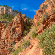
The North Rim of the Grand Canyon doesn’t get nearly the traffic as its more touristy neighbor to the south. For one thing, it is a lot more remote. The North Kaibab Trail is the most difficult of the three trails that dissect the canyon, but it also holds the most varied ecosystem. Somewhat surprisingly, it is forested. With fir and aspen and scrub oak, along with...
Learn More
This hike has a reputation for being one of the best in the country, for good reason. The scenery, the environment, the trail (or lack thereof) are all unique and awe inspiring. You are actually hiking in the Virgin River through what is known as The Narrows in Zion Canyon. Steep sandstone cliffs rise a thousand feet or more on both sides of the river. The colors in the...
Learn More I am Jeff Clark, founder of Internet Brothers, producer of this blog, and passionate about hiking. I live in Western NC near the Blue Ridge and Great Smoky Mountains. Pisgah and Nantahala National Forests are just out my door, so the content will focus on these areas, but let me know what you would like to see on the site.


Copyright © 2011-2023 Internet Brothers. All Rights Reserved. ISSN 2324-6057
Designed by Elegant Themes | Powered by Wordpress | Logo by Design Aspirations