
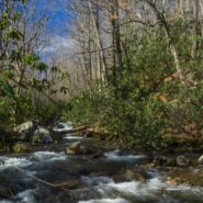
Jones Gap State Park sits on the Blue Ridge Escarpment in upstate South Carolina very near the state line with its neighbor to the north. Along with Caesars Head State Park, these two share an area known as Mountain Bridge Wilderness. The Jones Gap Trail follows the Middle Saluda River from the park visitor center along an old roadway built by Solomon Jones in the 1850s....
Learn More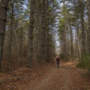
Located in the Guion Farm region of DuPont State Forest, this hike will take you to one of the lesser known, but equally memorable, of the exciting DuPont waterfalls. You are surrounded by majestic pine forest nearly throughout, with a walk along Grassy Creek for good measure. Most of the way is excellent double track surface, but that means you should listen for the...
Learn More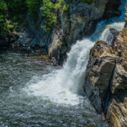
Located at milepost 316.5 along the Blue Ridge Parkway, Linville Falls moves in several distinct steps, beginning in a twin set of upper falls, passing through a small twisty gorge, and culminating in a high-volume 45-foot plunge. The Linville River flows from its headwaters high on the steep slopes of Grandfather Mountain and cascades through these falls as it begins a...
Learn More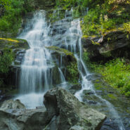
The Cosby section of the Smokies park is mostly known for its long, arduous treks to high country destinations like Mt. Cammerer and Inadu Knob. But there is another trail there that is more moderate in difficulty. A good day hike on Gabes Mountain Trail is the 4-mile round trip to Hen Wallow Falls, a 90-foot, multi-tiered cascade. This is cool, dense forest, some of it...
Learn More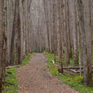
This is one of my new favorite Spring wildflower hikes in the Smokies. The flowers are brilliant along both the Bradley Fork and Cabin Flats Trails. The Smokemont region of the Smokies is one of the most convenient, located just a short few miles northwest of the Oconaluftee Visitor Center off Hwy 441. It is four miles up Bradley Fork to Cabin Flats Trail, then another...
Learn More
Congaree National Park, located in the heart of South Carolina, is a land of towering trees, of floods and fire, of woodland paths and water trails used by people for more than 10,000 years. This rare, old growth forest became a national park in 1976. These ancient trees have witnessed wars, slavery, freedom, and destruction. There are 25 miles of hiking trails in...
Learn More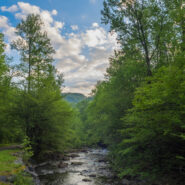
Perhaps the finest creek side trail in all of Great Smoky Mountains National Park, Middle Prong Trail actually follows Lynn Camp Prong. Lynn Camp and Thunderhead Prong join to form Middle Prong just below the trailhead. You will walk alongside Lynn Camp Prong for the entire length of this hike, passing dozens of swift cascades and two exciting waterfalls. Look for a wide...
Learn More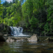
One of the most popular hiking trails in Great Smoky Mountains National Park, Abrams Falls at the west end of Cades Cove has the full Smokies package all in one. Here you can find rich, bountiful forest with a floor of colorful spring wildflowers, a rushing creek that provides refreshing nourishment for all the plants and wildlife, good exercise as you climb up and over...
Learn More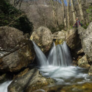
Yellowstone Prong has some of the most rugged terrain in all of the Pisgah Ranger District. Paralleling the Blue Ridge Parkway from Looking Glass Rock Overlook at milepost 417, and climbing the drainage from Skinny Dip Falls to Yellowstone Falls, this hike in, along, and above Yellowstone Prong may be the most challenging mile I have undertaken. You will scramble over...
Learn More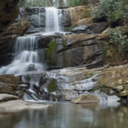
Some of the earliest wildflowers of the new season can be found on the Green River Game Lands near the North and South Carolina border. The elevation isn’t quite as high here as it is in most of the mountains of WNC, so the flowers get a little bit of a head start. Look for chickweed, rue anenome, wake robin trillium, blue and Canadian violets, robins plantain and...
Learn More
Deep Creek is one of many popular recreation areas found in Great Smoky Mountains National Park. Camping and picnicking are in abundance, as well as plenty of waterways for fishing and tubing. The assorted hiking trails also make it a fun destination for you and me. This hike, a combination of two different small loop trails affords the opportunity to visit the three...
Learn More
Elkmont is a nice area of the Smokies to visit in winter. It’s quiet, historic, alive with waterways, and offers views of the surrounding mountains through the leafless trees. Little River is beautiful as always, the climb up and over Cucumber Gap is invigorating, and the timeless cottages of Daisy Town along Jakes Creek harken back to a simpler time in the...
Learn More
The Little River headwaters region of the Smokies was heavily logged in the early 20th century. As a result, a community called Elkmont sprung up in the valley below to support the lumberjacks and their families. Elkmont eventually became a mountain resort for the well-to-do of eastern Tennessee with its rustic cabins along the river. These days those quaint cottages...
Learn More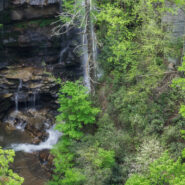
Like its partner, Little Bradley Falls, this hike is found in a remote corner of the Green River Game Lands near Saluda, NC that enables you to enjoy beautiful waterfalls. Big Bradley Trail follows Cove Creek along its path to an eventual meeting with Green River, but before it gets there, it free-falls 75 feet over the stone precipice at Big Bradley Falls. Bring your...
Learn More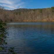
Named for an opportunistic traitor who supported the Crown during the Revolutionary War, Paris Mountain State Park was constructed by the Civilian Conservation Corps during the Great Depression. Richard Pearis owned 150,000 acres including what is now Greenville, SC and this state park north of the city. Once no more than a rural retreat, Paris Mountain is now a bustling...
Learn More
What is the first thing that comes to your mind when you think of the Smokies? Is it 6,000 foot mountaintop vistas that expand the imagination? Perhaps you think of the half-million acres of forest or the hundreds of varieties of wildflowers. There is one other constant in Great Smoky Mountains National Park, and that is water. Cataloochee Valley is surrounded on all...
Learn More
Located in the heart of DuPont State Forest, Three Lakes Trail does exactly what its name implies… it takes you to a trio of very picturesque lakes near Conservation Road. Lake Dense is an ideal stop for a family picnic. Lake Alford, really more of a pond, may be the most vivid and charming of all. The largest, Lake Julia, is breathtaking from every angle. Add to...
Learn More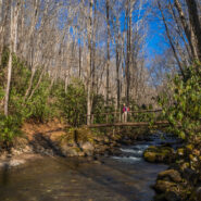
Bryson City, NC is located on the far southern boundary of Great Smoky Mountains National Park and hosts the Deep Creek and Lakeview regions of the park. Noland Creek Trail runs north/south off Lakeview Drive between Fontana Lake and the Noland Divide high above in the mountains. The trailhead is one mile north of the lake and heads in both directions. On this day Ken...
Learn More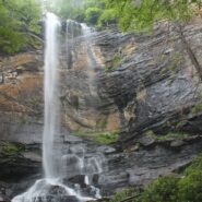
Jones Gap State Park sits on the Blue Ridge Escarpment in upstate South Carolina very near the state line with its neighbor to the north. Along with Caesars Head State Park, these two share an area known as Mountain Bridge Wilderness. The Jones Gap Trail follows the Middle Saluda River along an old roadway built by Solomon Jones in the 1850s. In this cove backcountry the...
Learn More
The Smokemont region of the Smokies is one of the most convenient, located just a short few miles northwest of the Oconaluftee Visitor Center off Hwy 441. The trailhead for Bradley Fork starts in the back of the Smokemont Campground, surrounded by the Smokies ubiquitous waterways. It’s only a mile and change up Bradley Fork Trail to its meeting with Chasteen Creek...
Learn More
Located in the far southern region of the Smokies, near Fontana Village and the Little Tennessee River, Twentymile is an area of the national park that is a little less traveled. Primarily used by backpackers as a means of accessing remote park highlights like Gregory Bald or Shuckstack Fire Tower on the Appalachian Trail, Twentymile can also be enjoyed by day hikers or...
Learn More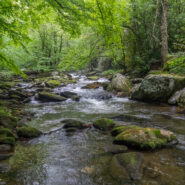
Joyce Kilmer-Slickrock Wilderness straddles the North Carolina / Tennessee line near the southern borders of the states, with about 75% of its 17,000 acres contained in NC. Six trailheads provide access to more than 60 miles of trail within the designated wilderness, which typically follow ridge tops or drop into the shady drainages. Perhaps the most atypical trail...
Learn More
Chimney Tops is one of the more popular destinations in the Smokies because of its central location, rugged beauty, and challenging access. And challenging it is. While short in distance, the trails that lead to the summit of Chimney Tops are steep and strenuous. Accessible from two trails, one below that climbs from Hwy 441 to the top, and one above that drops down from...
Learn More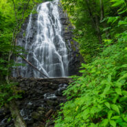
Crabtree Falls is a 70 foot cascade on Big Crabtree Creek, a short hike from the Blue Ridge Parkway. The creek drops over a black rock face with many small ledges, giving it a delicate web-like appearance. A trail descends 500 feet over the course of a mile as it leads to a footbridge crossing the creek at the base of the falls. In the Spring, an impressive array of...
Learn More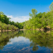
Established in 1972, Buffalo National River flows freely for 135 miles in Arkansas and is one of the few remaining undammed rivers in the lower 48 states. Once you arrive, prepare to journey from running rapids to quiet pools while surrounded by massive bluffs as you cruise through the Ozark Mountains. At a large curve in the river known as Horseshoe Bend, you can access...
Learn More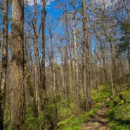
You know how some hikes can be kinda boring, then have a big reward like an outstanding overlook at the end? Or perhaps others will wind through a stunning forest only to peter out? Well, this hike located in the Greenbrier section of the Smokies has neither problem. The Porters Creek Trail is an exciting adventure from start to finish. I would describe it as a play with...
Learn More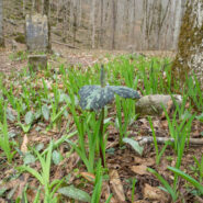
Venturing more into the central part of Tennessee to the Cumberland Plateau has been a goal of mine for some time. The name “Walls of Jericho” kept cropping up, so that clinched the destination. So what is this hike with the biblical name? The place known as the Walls of Jericho is a narrow canyon, about a half-mile long, with 200-foot-high vertical limestone...
Learn More
Located on the Tims Ford Reservoir, the 2,200-acre Tims Ford State Rustic Park sits in the shadows of the Cumberland Plateau in south-central Tennessee. There are 6.5 miles of unpaved hiking trails found within the park, in addition to 22 miles of bike trails that may also be used for hiking. Two of the three hiking trails begin at the park Visitor Center, while the...
Learn More I am Jeff Clark, founder of Internet Brothers, producer of this blog, and passionate about hiking. I live in Western NC near the Blue Ridge and Great Smoky Mountains. Pisgah and Nantahala National Forests are just out my door, so the content will focus on these areas, but let me know what you would like to see on the site.


Copyright © 2011-2023 Internet Brothers. All Rights Reserved. ISSN 2324-6057
Designed by Elegant Themes | Powered by Wordpress | Logo by Design Aspirations