
If you are looking for a solid prep hike for the Appalachian Trail or just want to hike one of National Geographic Adventure’s top North American hikes, look no further than the Art Loeb Trail near Brevard, NC. Rather than a loop trail, the Art Loeb Trail runs northbound for 30 miles from the Davidson River Campground to the Daniel Boone Boy Scout Camp. The...
Learn More
Popular trails in the Shining Rock and Middle Prong Wilderness along the Blue Ridge Parkway in Haywood County, North Carolina are included in a trail improvement plan for the Pisgah National Forest. “Each year, several million visitors come to experience the natural beauty and rich history of the Pisgah,” said Dave Casey, the head ranger for the Pisgah district of the...
Learn More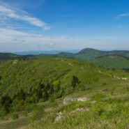
When looking for some WNC high country scenery and perhaps refreshing cool air on a warm day, one of the first destinations I think of is the Black Balsam area at milepost 420 on the Blue Ridge Parkway. There are half a dozen mountains here that stand above 6,000 feet, with encompassing 360° views from their treeless summits. This land that lies between the Shining...
Learn More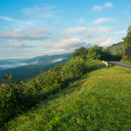
Every couple weeks or so during the green seasons I travel up to milepost 413 on the Blue Ridge Parkway. Friends of the BRP has a volunteer program called Adopt-an-Overlook that I have participated in for six years. I am responsible for keeping Pounding Mill Overlook clean and green, trash free, and desirable for the tourists. Saturday, August 13, 2016 was one of those...
Learn More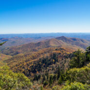
Looking for a short, easy, serene getaway in the high country that offers outstanding long distance views of the Blue Ridge Mountains? This is the trail for you. This little stretch of the famous Mountains to Sea Trail will take you from Black Balsam Road, through a dark and deep balsam spruce forest, across Silvermine Bald and on to Chestnut Bald to a splendid overlook...
Learn More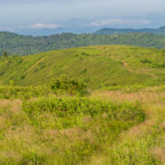
There is a notch between two wildernesses in the Pisgah National Forest high country. Shining Rock Wilderness is to the northeast, and Middle Prong Wilderness is to the west of this pie-shaped cut in the topology. In between are two bald mountaintops that exceed 6,000 feet elevation. To the locals the area is called simply… Black Balsam. The air is fresh (usually),...
Learn More
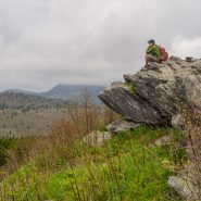
Deep in the heart of Shining Rock Wilderness is the namesake, a mountain made of quartz, standing more than 6,000 feet. On bright sunny days you can see the white quartz “shining” from miles away. The Cherokee called it Datsu’nălâsgûñ’yĭ, “where their tracks are this way,” that refers to a white rock that is said to have tracks of Tsul...
Learn More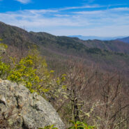
Backcountry wilderness. If you really want to get a taste, then this hike is for you. Starting at the remote Camp Daniel Boone, the northern terminus of the Art Loeb Trail enters Shining Rock Wilderness immediately. As you begin the nearly 2,000′ ascent to Deep Gap, on the southern shoulder of Cold Mountain, you will cross numerous streams as you hike through...
Learn More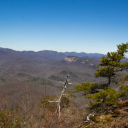
Cedar Rock is one of several granite pluton monoliths found in the Davidson River area of Pisgah National Forest. More difficult to get to than its nearby brethren, Looking Glass and John Rock, Cedar Rock has outstanding long distance views from both the east and west sides of its summit. You will have to work to get there, climbing nearly 1,700 feet from the valley...
Learn More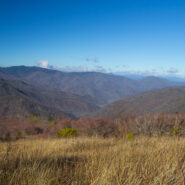
The Black Balsam area of Pisgah National Forest is surrounded by Middle Prong Wilderness on the west, and Shining Rock Wilderness on the east. Some of the best hiking found in Western North Carolina lies in this high country just north of the Blue Ridge Parkway. At the end of Black Balsam Road at milepost 420 on the Parkway, the Ivestor Gap Trail will take you deep into...
Learn More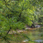
Section 1 of the Art Loeb Trail is in Pisgah National Forest near Brevard, NC overlooking the Davidson River Recreation Area. The North Slope Trail is a loop contained within the boundary created by the Art Loeb and the river. Between the two trails is a connector. Combining the two via the connector makes an 8-mile loop that takes in a large portion of the forest above...
Learn More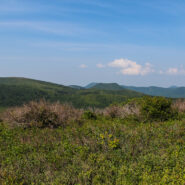
Milepost 420 on the Blue Ridge Parkway is where you will find Black Balsam Road. It’s a short drive to a spruce forest where the Art Loeb Trail crosses the road and heads up onto the balds. This is North Carolina high country. There are several mountains greater than 6000 feet with treeless summits, affording spectacular 360° views of the surrounding Blue...
Learn More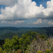
Pilot Mountain stands 5084 feet above the western edge of Pisgah National Forest, near the Blue Ridge Parkway and Looking Glass Rock. There are three ways to get to its summit, but the one I enjoy most is the section of the Art Loeb Trail from Gloucester Gap along Forest Road 475. It isn’t particularly long, but it is quite strenuous. You will get your exercise...
Learn More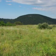
Flat Laurel Creek is in the area just north of the Pisgah Ridge and in between the Shining Rock and Middle Prong Wildernesses. It drains from Sam Knob and Little Sam Knob and runs to the West Fork of the Pigeon River. The trail that bears its name starts at the headwater and travels 3.7 miles around the west side of Little Sam until it meets Hwy. 215 and joins the...
Learn More
This a continuation beyond the hike described in the Black Balsam Knob and Tennent Mountain trail report. The Art Loeb Trail continues down the north side of Tennent Mountain to Grassy Cove. There it meets the Ivestor Gap Trail for a lengthy hike into Shining Rock Wilderness. The area was named by the Cherokee for the large deposits of quartz found along what has become...
Learn More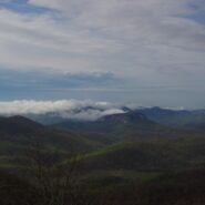
Frequently. That is how many times I have done this hike. So many, I’ve lost count. I love the western North Carolina high country, and this area along the Blue Ridge Parkway known as Black Balsam has nearly a dozen peaks over 5,800 feet elevation, with Black Balsam Knob being the highest at 6,214. This area has some of the highest hiking on the Parkway. Many of...
Learn More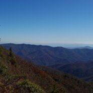
Cold Mountain gained national attention following the publishing of Charles Frazier’s Civil War era novel in 1997. Western NC hiking enthusiasts have known of its appeal for much longer. Cold Mountain is a real mountain that stretches 6030′ and is located in the Shining Rock Wilderness and Pisgah National Forest in North Carolina. You can reach the spur trail...
Learn More
This hike is in one of my favorite areas of Pisgah National Forest along the Blue Ridge Parkway in western North Carolina. It lies in a little corner between Middle Prong Wilderness and Shining Rock Wilderness where the mountain tops are bald and exceed 6000′. This hike occurred on March 24, 2011 beginning at 10:00AM and ending about 3:00PM. The goal on this day...
Learn More I am Jeff Clark, founder of Internet Brothers, producer of this blog, and passionate about hiking. I live in Western NC near the Blue Ridge and Great Smoky Mountains. Pisgah and Nantahala National Forests are just out my door, so the content will focus on these areas, but let me know what you would like to see on the site.


Copyright © 2011-2023 Internet Brothers. All Rights Reserved. ISSN 2324-6057
Designed by Elegant Themes | Powered by Wordpress | Logo by Design Aspirations