
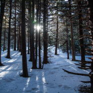
There was a snowstorm over Roan Mountain the last Friday in February, 2020. Seeing Roan Highlands covered in a blanket of snow is always a highlight of WNC winter. So on Sunday, March 1st I set out for this glorious destination high above the little town of Bakersville. It is quickly becoming one of my favorite things to do in winter. This makes three in a row now. As...
Learn More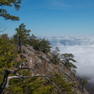
August 2005 saw the Carolina Mountain Land Conservancy (now Conserving Carolina) and The Nature Conservancy purchase a 1,568-acre tract of land south of Lake Lure known as “World’s Edge” for $16 million with the intention of transferring the land as the first to be added to the new Chimney Rock State Park. World’s Edge contains a mile-long set of steep...
Learn More
Tucked away in the northeastern corner of DuPont State Forest in Western North Carolina, Stone Mountain is the highest point in the state forest at 3,620 feet. Appropriately named for the exposed granite slab that traverses its summit, Stone Mountain offers a near 270° view of the surrounding terrain to winter hikers. Since the first time I went, nearly 12 years ago,...
Learn More
Few places in the Southern Appalachians are more scenic than Max Patch along the Appalachian Trail on the state line between North Carolina and Tennessee. Even more so when the magic of Fall coloring surrounds the mountaintop. You can see my complete trail report for Max Patch and Buckeye Ridge, and learn about an unexpected adventure I had a few years ago on my first...
Learn More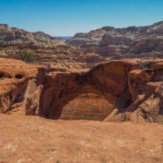
Named for Butch Cassidy, the late-19th century western outlaw who hung out in these parts, Cassidy Arch stands on a precipice overlooking the Grand Wash in Capitol Reef. Cassidy Arch Trail climbs 670 feet from the wash to a slickrock bench high above the canyon. Iconic landmarks like Capitol Dome are visible along the trail that hangs on the canyon ledge. Better wear...
Learn More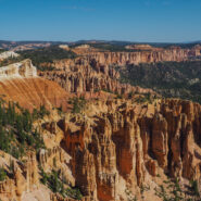
Bristlecone Loop, accessible from Rainbow Point at the southern-most end of Bryce Canyon National Park, meanders through a spruce-fir forest atop the highest portion of the park, reaching elevations over 9,100 feet. This short and easy stroll passes by bristlecone pines up to 1,800-years-old and experiences vistas reaching into Dixie National Forest and Grand...
Learn More
Golden hour is special for any place with picturesque scenic beauty, especially if you also happen to like photography. There aren’t many places more stunning during the golden hour — that time right after sunrise and right before sunset — than Bryce Canyon. There are even viewpoints named for these wonderful times… Sunrise Point and Sunset Point....
Learn More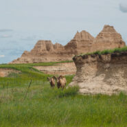
The Castle Trail is the longest in Badlands National Park, but can be broken up with three distinct trailheads. Medicine Root connects with Castle Trail at Saddle Pass and Old Northeast Road creating a loop of about five miles. The terrain is mixed grass prairie and arroyo, with views of the Badlands pinnacles throughout. Keep your eyes peeled for wildlife. It is...
Learn More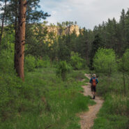
I think of the Hell Canyon Trail in Black Hills National Forest, South Dakota as two hikes. There’s the stroll through the canyon with lush trees and bushes and a wide assortment of colorful wildflowers. Then, there’s the path along the canyon rim that exposes the devastation of the 2000 Jasper Fire, the largest in Black Hills history. The undergrowth is...
Learn More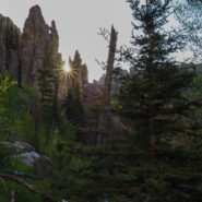
This is the hard way to get to the summit of 7,242′ Black Elk Peak, the highest in South Dakota. But, it affords you the opportunity to hike through the incredible Cathedral Spires, massive granite pinnacles that dominate the landscape in the Black Hills National Forest. Between the spires and the summit you pass through the rugged Black Elk Wilderness, named for...
Learn More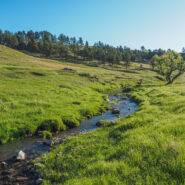
This hike in the heart of Wind Cave National Park combines two trails to make a 5-mile loop, and the two couldn’t be any more different. Centennial Trail takes you through lush meadows, and a rocky canyon lined with pine, while Lookout Point Trail experiences the wide open spaces of the South Dakotan prairie. Centennial follows the path of Beaver Creek through the...
Learn More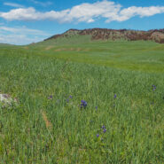
Located in the remote northern corner of Wind Cave National Park, Boland Ridge Trail crosses the wide open prairie, then a series of ridge climbs offer panoramic views of the Black Hills, the Red Valley, and the western South Dakota plains beyond. Because of the isolated nature, elk and bison are often seen along this trail. In fact, we had to cut this one about a mile...
Learn More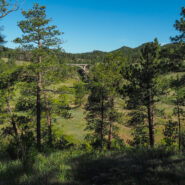
When you’re looking to get a good overview of the “above ground” features of Wind Cave National Park, what better way than to climb to the highest point. Fortunately, that’s easy to do with the Rankin Ridge Nature Trail. This one-mile loop takes you to an old retired fire tower with views into the Black Hills and as far away as The Badlands. Watch...
Learn More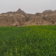
Our evening arrival to Badlands National Park coincided with a torrential storm that brought rain, wind and hail to the region. We learned the next morning that the campground was flooded, as was every arroyo in the park. We soon learned that the soft clay of the Badlands terrain does not mix well with lots of rain. Think quicksand — you sink inches with each step...
Learn More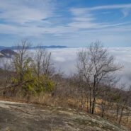
This park sits right on the cliff’s edge of the Blue Ridge Escarpment that drops down from the mountains in western North Carolina to the upcountry of South Carolina. The park is more than 3,000 acres of trails, lakes, cabins and camping. Pinnacle Mountain Trail is the most challenging within the park, with a climb that exceeds 2,300 feet. The lower section follows...
Learn More
This trail follows the McCullough Creek drainage up the gulch beneath the massive summit of 14,225′ Quandary Peak. It starts on an old mining road south of Breckenridge, CO, then changes to single track trail as it climbs the gulch. You’ll pass through pine and fir forest, get splashed by White Falls, marvel at the colorful granite, and count the variety of...
Learn More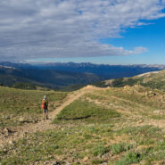
The easier of the trails at Loveland Pass, West Ridge surrounds two sides of the bowl that makes up the Loveland area and the I-70 corridor over the Continental Divide. Still, at 11,990 feet, this is no piece of cake for folks like me who are used to mountains no more than half the elevation. Several ski slopes are visible from the ridge. Look too for cute rodents to...
Learn More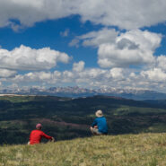
This marvelous example of Rocky Mountain vistas starts, oddly enough, directly beside Interstate-70 at Colorado’s 10,585′ Vail Pass. The trail winds through forest and meadow, then climbs steeply above treeline to Uneva Ridge, 1,500 feet above. Along the way you will enjoy breathtaking views of four distinct mountain ranges as you pass into Eagles Nest...
Learn More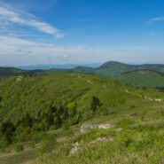
When looking for some WNC high country scenery and perhaps refreshing cool air on a warm day, one of the first destinations I think of is the Black Balsam area at milepost 420 on the Blue Ridge Parkway. There are half a dozen mountains here that stand above 6,000 feet, with encompassing 360° views from their treeless summits. This land that lies between the Shining...
Learn More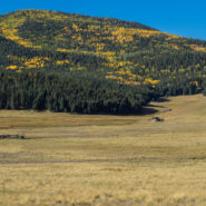
Valles Caldera is a 13.7-mile wide volcanic bowl in the Jemez Mountains of northern New Mexico near Los Alamos. About 1.25 million years ago, a spectacular volcanic eruption created this circular depression now known as the Valles Caldera. The Valles Caldera Preservation Act of 2000, signed by President Clinton, created the National Preserve. The preserve is known for...
Learn More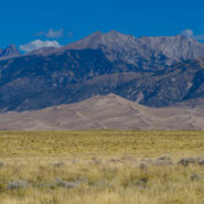
Great Sand Dunes National Park and Preserve protects the tallest sand dunes in North America, and a whole lot more. From the San Luis Valley floor to the crest of the 13,000 foot peaks in the Sangre de Cristo Mountains — the park and preserve contains ecosystems ranging from sand sheet to dunes to tundra — each supporting specially adapted plant, animal and...
Learn More
There’s a reason they call it Summit County. An old mining road climbs from Hoosier Pass above 12,000 feet and is surrounded by several of Colorado’s famous fourteeners. The first half of the road meanders through a spruce and fir forest with occasional views of the massive mountains that envelop the region. The rest of the way is above treeline, offering...
Learn More
The U.S. Forest Service has done a nice job of building trails up the watersheds that drain into the Town of Vail. Included among these is Spraddle Creek, located across I-70 from Vail Village. The reward at the top of the ridge is a mountain meadow that overlooks Vail, Beaver Creek ski mountain, and the Holy Cross Wilderness far, far away. Hike in late September for an...
Learn More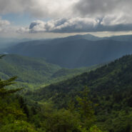
Love the high country in summer. It’s like getting an extra month of spring. For much of its length through the Western North Carolina mountains, the Mountains to Sea Trail parallels the Blue Ridge Parkway. There is an area near mile marker 434 on the Parkway, beneath Old Bald, where the MST winds through mixed forest and high mountain meadows teeming with...
Learn More
I have hiked to Hemphill Bald from the east along the Cataloochee Divide many times. However, this was the first time approaching from the west on the Hemphill Bald Trail from Polls Gap. This made my second foray into the Heintooga region of the Smokies in recent weeks, another beautiful piece of the national park that doesn’t get enough attention. This trail would...
Learn More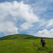
You can see them from Roan Highlands. They appear when viewed from Linville Gorge and Grandfather Mountain too. The long, green balds that comprise Little Hump and Big Hump Mountains stick out like limes in a grapefruit basket. And, you can see all those other landmarks from the Hump Mountains. The iconic Appalachian Trail (AT) arrives from the Highlands of Roan to...
Learn More
The Appalachian Trail splits the states of North Carolina and Tennessee through most of the breadth of Great Smoky Mountains National Park. Hugging the state line as it traverses the rugged and remote ridges, the AT is a favorite destination for day hikers and thru hikers alike. There is a three and a half mile stretch from Newfound Gap to the summit of Mt. Kephart, and...
Learn More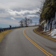
Walking the Blue Ridge Parkway in winter is a great way to get a slow-motion view of the wonderful vistas that whiz by at 45 mph in your car. The Parkway is closed so you don’t have to worry about traffic. The only concern really is perhaps slipping on snow or ice. This latest in the Photo Essay series looks at a 4-mile stretch of the BRP between mileposts 412 and...
Learn More I am Jeff Clark, founder of Internet Brothers, producer of this blog, and passionate about hiking. I live in Western NC near the Blue Ridge and Great Smoky Mountains. Pisgah and Nantahala National Forests are just out my door, so the content will focus on these areas, but let me know what you would like to see on the site.


Copyright © 2011-2023 Internet Brothers. All Rights Reserved. ISSN 2324-6057
Designed by Elegant Themes | Powered by Wordpress | Logo by Design Aspirations