
August 2005 saw the Carolina Mountain Land Conservancy and The Nature Conservancy purchase a 1,568-acre tract of land south of Lake Lure known as “World’s Edge” for $16 million with the intention of transferring the land as the first to be added to the new Chimney Rock State Park. World’s Edge contains a mile-long set of steep slopes on the eastern edge...
Learn More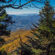
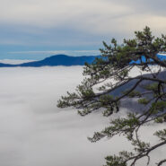
Sometimes things just don’t go exactly as planned. But making the most of what’s available is what sets hiking apart. Everything doesn’t have to go perfectly to still enjoy the day. Such was the case with this hike across the Plott Balsams mountain range from Waterrock Knob on the Blue Ridge Parkway. You’re in rarefied air here, with the entire...
Learn More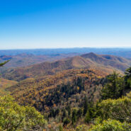
Looking for a short, easy, serene getaway in the high country that offers outstanding long distance views of the Blue Ridge Mountains? This is the trail for you. This little stretch of the famous Mountains to Sea Trail will take you from Black Balsam Road, through a dark and deep balsam spruce forest, across Silvermine Bald and on to Chestnut Bald to a splendid overlook...
Learn More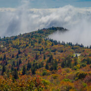
Leaf peepers head to Graveyard Fields in late September for the annual ritual of Autumn color in the high country. Located at mile 418 on the Blue Ridge Parkway, Graveyard Fields is one of the earliest locations to begin the chromatic display, as well as one of the most intense. From the bright red of the blueberry and sumac bushes, to the multi-colored hues of the maple...
Learn More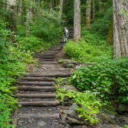
Chimney Tops is one of the more popular destinations in the Smokies because of its central location, rugged beauty, and challenging access. And challenging it is. While short in distance, the trails that lead to the summit of Chimney Tops are steep and strenuous. Accessible from two trails, one below that climbs from Hwy 441 to the top, and one above that drops down from...
Learn More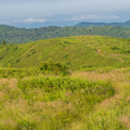
There is a notch between two wildernesses in the Pisgah National Forest high country. Shining Rock Wilderness is to the northeast, and Middle Prong Wilderness is to the west of this pie-shaped cut in the topology. In between are two bald mountaintops that exceed 6,000 feet elevation. To the locals the area is called simply… Black Balsam. The air is fresh (usually),...
Learn More
Deep in the heart of Shining Rock Wilderness is the namesake, a mountain made of quartz, standing more than 6,000 feet. On bright sunny days you can see the white quartz “shining” from miles away. The Cherokee called it Datsu’nălâsgûñ’yĭ, “where their tracks are this way,” that refers to a white rock that is said to have tracks of Tsul...
Learn More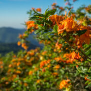
When the Southern Appalachians are your home, the month of June simply isn’t complete without a visit to Roan Highlands for the annual rhododendron and azalea bloom. Like Julie Andrews sang years ago, “these are a few of my favorite things.” From the first time I set foot on Round Bald, I knew this was someplace special. The grassy ridge of the...
Learn More
Clingmans Dome is the highest point in Great Smoky Mountains National Park, in the state of Tennessee, and along the Appalachian Trail. Standing 6,643 feet, it is also the third highest peak in the East, only 41 feet lower than the tallest. Several hiking trails surround the summit of Clingmans Dome, including the Forney Ridge Trail that heads south to the picturesque...
Learn More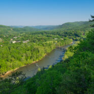
Hot Springs, NC is an Appalachian Trail Community that sits along the French Broad River in the Appalachian Ranger District of Pisgah National Forest. The Appalachian Trail was built through Hot Springs more than seven decades ago, and today white blazes still mark the path through town and over the bridge across the river, before heading north up to the vista, Lover’s...
Learn More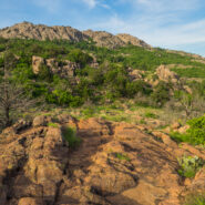
Wild, rugged, and weathered — the Wichita Mountains Wildlife Refuge in central Oklahoma is a symbol of the old west standing at the threshold of modern times. The natural attractions of the refuge are many and varied. In addition to viewing and photographing wildlife in their natural setting, visitors find the lakes, streams, canyons, mountains and grasslands ideal...
Learn More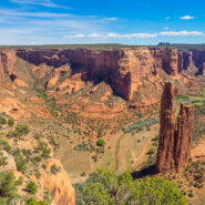
The labyrinth called Canyon de Chelly (pronounced d’SHAY) comprises several canyons that include Canyon de Chelly, Monument Canyon and Canyon del Muerto. At the mouth of the canyons near the tribal town of Chinle, in northeastern Arizona, the rock walls are only 30 feet high. Deeper in, the bright red sandstone bluffs rise dramatically to stand more than a thousand...
Learn More
There are lots of little maintenance trails alongside the Blue Ridge Parkway that don’t show up on any trail maps or have any signs to let you know they are there. One of those is a hidden gem in the high country at milepost 420 directly across from the Black Balsam spur road. It’s great for an hour stroll to brighten you senses, or if you’re looking...
Learn More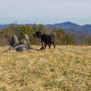
Blue Ridge Pastures is a grassy knoll northwest of Bearwallow Mountain along the Buncombe/Henderson County line. With terrific views of Hickory Nut Gorge, and on clear days The Great Craggy and Black Mountains, the reward for your hard work pays off. The Trombatore Trail will make you climb twice for your reward, once before and once after, but keep that reward in mind...
Learn More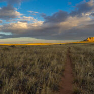
Located on the east side of the Island in the Sky District, Lathrop Canyon drops off the mesa to the White Rim, then dives all the way to the Colorado River. The Lathrop Trail enables a short, medium or long hike, depending on the level of the canyon you wish to tackle. The first couple miles are a sandy straight and level shot through prairie-like grassland. As you...
Learn More
Perhaps the best hike in all of Capitol Reef National Park, Upper Muley Twist Canyon is a full-featured Utah adventure that includes narrow canyons, expanses of slickrock, large arches, and dramatic vistas from the top of the incomparable Waterpocket Fold. There are opportunities for side trips to slot canyons and other exciting off-trail experiences, as well as perilous...
Learn More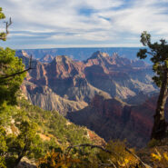
Located on the very southern tip of the Kaibab Plateau, and the prime vista location for the North Rim of Grand Canyon, Bright Angel Point offers a bird’s-eye view of the meeting of Roaring Springs Canyon and Transept Canyon at the Bright Angel Fault. It is 4/10 mile from Grand Canyon Lodge to the point on a paved trail that offers several overlooks along the way....
Learn More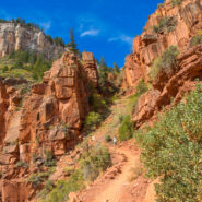
The North Rim of the Grand Canyon doesn’t get nearly the traffic as its more touristy neighbor to the south. For one thing, it is a lot more remote. The North Kaibab Trail is the most difficult of the three trails that dissect the canyon, but it also holds the most varied ecosystem. Somewhat surprisingly, it is forested. With fir and aspen and scrub oak, along with...
Learn More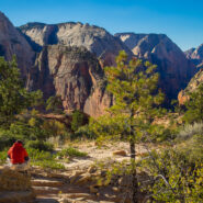
Angels Landing is a unique fin sandstone monolith that erupts 1,500 feet from the floor of Zion Canyon. The trail to the top is one of the most popular hikes in Zion National Park, certainly the most thrilling. For someone like me with heights and edges phobia and vertigo, it’s a little too much excitement, but there is a compromise. You can still enjoy most of the...
Learn More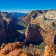
Mount Baldy surveys Zion Canyon at 6,521 feet elevation, more than 2,100 feet above the valley floor. Jutting out from Mt. Baldy into one of the widest sections of Zion Canyon, Observation Point commands a view of nearly every major attraction, particularly those like Angels Landing and The Organ at Big Bend. Hikers receive a spectacular vista of the lower end of Zion...
Learn More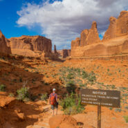
Within Arches National Park you will discover a landscape of contrasting colors, landforms and textures unlike any other in the world. The park has over 2,000 natural stone arches, in addition to hundreds of soaring pinnacles, massive fins and giant balanced rocks. This red rock wonderland will amaze you with its formations, refresh you with its trails, and inspire you...
Learn More
Another foray into the Black Mountains led us to summits with names like Point Misery, Little Butt and Big Butt. The Big Butt Trail takes off from Balsam Gap on the Blue Ridge Parkway along Brush Fence Ridge, roller-coastering across several peaks and gaps. The forest is filled with floral and fungal oddities, and old-growth spruce and pine that protect the ridge like...
Learn More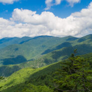
Hiking among the giants of the East. That’s what you’re doing when you take the Blue Ridge Parkway to Mt. Mitchell State Park for this trek on the Mountains to Sea Trail in the Black Mountains. With fabulous views of the Blacks and the Great Craggy Range, and closeup experiences with gnarly old growth fir and spruce krummholz, this stretch of the MtS is some...
Learn More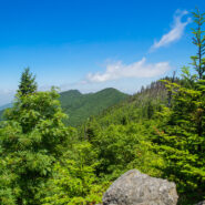
This hike will introduce you to a good cross section of the trails found in Mt. Mitchell State Park high atop the Black Mountains in Western North Carolina. Mt. Mitchell is the highest point in the Eastern United States at 6,684′, in fact six of the 10 highest peaks are found in the Blacks. The climate of the Black Mountains is more like Canada than North Carolina....
Learn More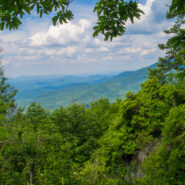
The Cosby area in the Smokies offers quite a few long and rugged hikes from valley floor to mountain tops, including this leg-wrecker from the Cosby Campground to the Appalachian Trail on the Snake Den Ridge Trail. Even up top there are multiple potential destinations. We chose Inadu Knob and the old search & rescue helicopter pad at Deep Creek Gap for the views...
Learn More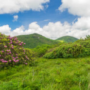
June means catawba rhododendron at Craggy Gardens. Located northeast of Asheville on the Blue Ridge Parkway, Craggy Gardens is loaded with the purple and maroon beauties. There are two short, easy trails near the Visitor Center that access mountaintops for spectacular vista views and bunches and bunches of rhodies. Craggy Pinnacle takes you above 5,800 feet for a view of...
Learn More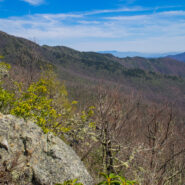
Backcountry wilderness. If you really want to get a taste, then this hike is for you. Starting at the remote Camp Daniel Boone, the northern terminus of the Art Loeb Trail enters Shining Rock Wilderness immediately. As you begin the nearly 2,000′ ascent to Deep Gap, on the southern shoulder of Cold Mountain, you will cross numerous streams as you hike through...
Learn More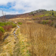
When the Blue Ridge Parkway reopens each year in early spring, it is great to get back into the high country at milepost 420. That means the Black Balsam area and Shining Rock Wilderness. An oft overlooked trail on the west side of the wilderness is Little East Fork, a twisty path that follows the Little East Fork of the Pigeon River from Shining Rock Gap to the Daniel...
Learn More I am Jeff Clark, founder of Internet Brothers, producer of this blog, and passionate about hiking. I live in Western NC near the Blue Ridge and Great Smoky Mountains. Pisgah and Nantahala National Forests are just out my door, so the content will focus on these areas, but let me know what you would like to see on the site.


Copyright © 2011-2023 Internet Brothers. All Rights Reserved. ISSN 2324-6057
Designed by Elegant Themes | Powered by Wordpress | Logo by Design Aspirations