
Those of you who have known me for awhile are aware that, since retirement, I have been what the National Park Service calls a VIP. Sounds pretentious, but really all it means is Volunteer in Parks. I help out at two, the Blue Ridge Parkway and Great Smoky Mountains National Park. Up on the Parkway I pick up litter, clean out storm drains, and do general tidying at one...
Learn More
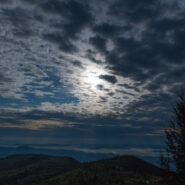
Does 2020 seem like a lost year so far? If you’re like me it has. I’ve been self-isolating since mid-March because of coronavirus. I only venture out to get groceries for my dad and myself. I have been hiking a grand total of once since March, and that time was only after entering Phase II of the grand reopening. Obviously soon after, positive cases began...
Learn More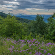
Cloudy and very windy. That’s what greeted me the morning of July 14, 2019 as I first stepped from my car at Pounding Mill Overlook (milepost 413). Those who know me also know that I’ve been picking up trash and otherwise maintaining this overlook on the Blue Ridge Parkway for each of the last 10 years. As I walked around to survey the accumulated trash since...
Learn More
There’s not much more beautiful than the high country along the Blue Ridge Parkway in June. The days are long. The forest has completed its greening and the heath bushes are in bloom. If you catch the sights in the evening or very early morning you can even avoid the crowds. I’ve been on the shelf for a few weeks with an ankle injury while hiking, and was...
Learn More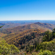
Looking for a short, easy, serene getaway in the high country that offers outstanding long distance views of the Blue Ridge Mountains? This is the trail for you. This little stretch of the famous Mountains to Sea Trail will take you from Black Balsam Road, through a dark and deep balsam spruce forest, across Silvermine Bald and on to Chestnut Bald to a splendid overlook...
Learn More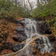
Occasionally a nice easy stroll to a beautiful waterfall is just what the doctor ordered. I made this a three and a half mile loop, but you can actually get to the waterfall in a mile round trip. The woods off FR 475B in Pisgah National Forest are dense and filled with mountain streams running down from the Blue Ridge high above. One of these streams is Log Hollow...
Learn More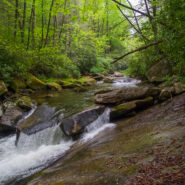
This short, little trail from Cove Creek to the State Fish Hatchery is often overlooked, but it will take you to some of the most gnarly whitewater on Davidson River. The trail is simple. It’s just a straight 1.1 mile shot from one end to the other, and then back. Ah, but have you ever seen a two-tiered trail? If you promise to be very, very careful on the river...
Learn More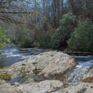
Southeast of the Cradle of Forestry National Historical Site is a remote area of Pisgah National Forest with trails that will take you along ridge lines with views of the Blue Ridge Parkway and Looking Glass Rock, then follow creeks and streams as they tumble down the mountains to the western end of South Mills River. You will encounter names like Squirrel Gap, Glady...
Learn More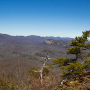
Cedar Rock is one of several granite pluton monoliths found in the Davidson River area of Pisgah National Forest. More difficult to get to than its nearby brethren, Looking Glass and John Rock, Cedar Rock has outstanding long distance views from both the east and west sides of its summit. You will have to work to get there, climbing nearly 1,700 feet from the valley...
Learn More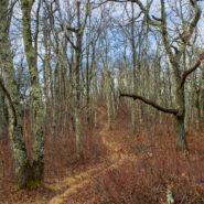
Quite frequently in winter, the Blue Ridge Parkway will be closed for snow and ice. Not great fun for those who wish to drive along the beautiful ridges. Ah — but it’s the perfect time for hikers to get out on the trails that parallel the Parkway — like the Mountains to Sea. Between Pigeon Gap and Bennett Gap at miles 412-414 the Mountains to Sea Trail...
Learn More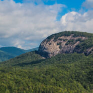
The always popular Cat Gap Loop Trail is a jumping off point for many great hikes within the Davidson River area of Pisgah National Forest. Included among them is the picturesque John Rock, one of the area’s plutons that stand over the recreation area. With views of the Fish Hatchery, Looking Glass Rock, Pilot Mountain and the ridges that run to Graveyard Fields,...
Learn More
This is a two-part hike with a short drive on a forest service road in between. Both the Case Camp Ridge Trail and the North Face Trail start on Forest Road 475B in Pisgah National Forest. The first climbs 1000 feet in 1.7 miles to the Blue Ridge Parkway near Cherry Gap at mile 416. It’s a short walk from the trail to the Cherry Cove Overlook and a close-up view of...
Learn More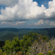
Pilot Mountain stands 5084 feet above the western edge of Pisgah National Forest, near the Blue Ridge Parkway and Looking Glass Rock. There are three ways to get to its summit, but the one I enjoy most is the section of the Art Loeb Trail from Gloucester Gap along Forest Road 475. It isn’t particularly long, but it is quite strenuous. You will get your exercise...
Learn More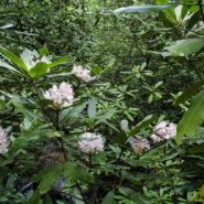
Another of the myriad of hikes along Forest Road 475 in Pisgah National Forest, this two-parter is near the Fish Hatchery and Pisgah Center for Wildlife Education. First we took a short trip up Forest Road 475B to Slick Rock Falls, then hiked to the base of Looking Glass Rock. The climbers love this area and we encountered some when we reached the base. The main hike was...
Learn More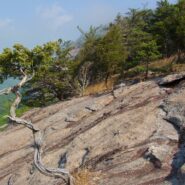
Perhaps the most popular hike in the Pisgah Ranger District of Pisgah National Forest, the Looking Glass Rock Trail is a good 3-mile leg stretcher to the top of the famous pluton. Probably not the most scenic hike is the area, but definitely popular because of ease of access, and a little less difficulty than some of the steeper monoliths. Looking Glass Rock is home to...
Learn More
Looking at a trail map or topographic map, the area of this hike within Shining Rock Wilderness can be somewhat confusing. There is the Greasy Cove Prong, a creek that runs off of the Grassy Cove Ridge. The trail is called Greasy Cove, but it starts/ends at Grassy Cove Top. I think the guys who named the area may have had a touch too much huckleberry wine. Regardless of...
Learn More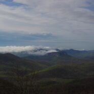
Frequently. That is how many times I have done this hike. So many, I’ve lost count. I love the western North Carolina high country, and this area along the Blue Ridge Parkway known as Black Balsam has nearly a dozen peaks over 5,800 feet elevation, with Black Balsam Knob being the highest at 6,214. This area has some of the highest hiking on the Parkway. Many of...
Learn More
This hike is in one of my favorite areas of Pisgah National Forest along the Blue Ridge Parkway in western North Carolina. It lies in a little corner between Middle Prong Wilderness and Shining Rock Wilderness where the mountain tops are bald and exceed 6000′. This hike occurred on March 24, 2011 beginning at 10:00AM and ending about 3:00PM. The goal on this day...
Learn More I am Jeff Clark, founder of Internet Brothers, producer of this blog, and passionate about hiking. I live in Western NC near the Blue Ridge and Great Smoky Mountains. Pisgah and Nantahala National Forests are just out my door, so the content will focus on these areas, but let me know what you would like to see on the site.


Copyright © 2011-2023 Internet Brothers. All Rights Reserved. ISSN 2324-6057
Designed by Elegant Themes | Powered by Wordpress | Logo by Design Aspirations