
Congaree National Park, located in the heart of South Carolina, is a land of towering trees, of floods and fire, of woodland paths and water trails used by people for more than 10,000 years. This rare, old growth forest became a national park in 1976. These ancient trees have witnessed wars, slavery, freedom, and destruction. There are 25 miles of hiking trails in Congaree, including Oakridge. Passing through a rich stretch of old growth forest, along the way you will cross a number of sloughs, or small creeks that carry floodwaters into and out of the park’s floodplain as the level of Congaree River rises and falls. Ken and I hiked Oakridge Trail on Wednesday, November 29, 2017 beginning at 9:15AM and ending about 2:15PM. Our plan was to take Boardwalk Trail to Weston Lake Trail, then on to Oakridge Trail. On the return we would catch the other side of each loop.
Hike Length: 9.7 miles Hike Duration: 5 hours
Hike Rating: Easy. The entire trail is level, so there is really no exertion other than simply walking. Make it as short or as long as you like with three loops.
Hike Configuration: Multiple loops Blaze: Numbered white
Elevation Change: 70 feet Gain: 135 feet Elevation Start: 175 feet
Trail Condition: Excellent. Some is boardwalk over swampy areas. The rest is hard-packed soil through the wilderness. Beware, however, that it can become quite muddy and wet during the rainy season.
Starting Point: Park Visitor Center.
Trail Traffic: There were a couple dozen on the Boardwalk Trail, but only one other on Oakridge Trail. We encountered perhaps half a dozen on Weston Lake Trail.
How to Get There: Congaree National Park is southeast of Columbia, SC. From I-77 take exit 5 onto SC 48 (Bluff Road). Go 10 miles and bear right on Old Bluff Road. Follow the signs to Congaree.
I just happened to notice it was going to be 70° in South Carolina the week after Thanksgiving. Seemed like a good time for a road trip. Congaree National Park, just southeast of Columbia, is only 2.5 hours from the mountains, so that seemed like a great opportunity to explore a new place. It was a good choice.
Just driving into Congaree National Park you can tell this place is different. I’ve been visiting and hiking the creeks and forests of the Blue Ridge and Great Smoky Mountains for years. This central Carolina floodplain is not the mountains. The forest is different. The aromas are different.
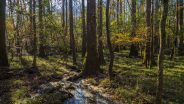
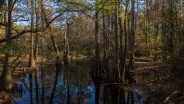
The Congaree River is bounded on both sides by bluffs that mark the edge of the floodplain and help contain floodwaters that cover much of the park each year. Those floods bring in minerals and other nutrients to the ecosystem. Most of the year the park is dry, but after a heavy rain sloughs and guts (small water channels) begin to fill.
Centuries ago, the southeastern North American continent was abundant in old growth forest floodplain. Today, more than 99 percent of it has been lost to pastures, farms and cities. The trees were cut for ships, railroads and buildings. 35 million acres are gone. Less than one half of one percent — 11,000 acres — is protected in Congaree National Park.
As soon as you begin hiking from the Harry Hampton Visitor Center (named for a journalist instrumental in protecting Congaree) on the Lower Boardwalk Trail you begin to notice the murky, swampy feel of the terrain on either side. Squirrels skitter about from dry spot to dry spot. Pileated woodpeckers dig for grubs in the fallen, wet trees.
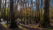
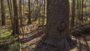
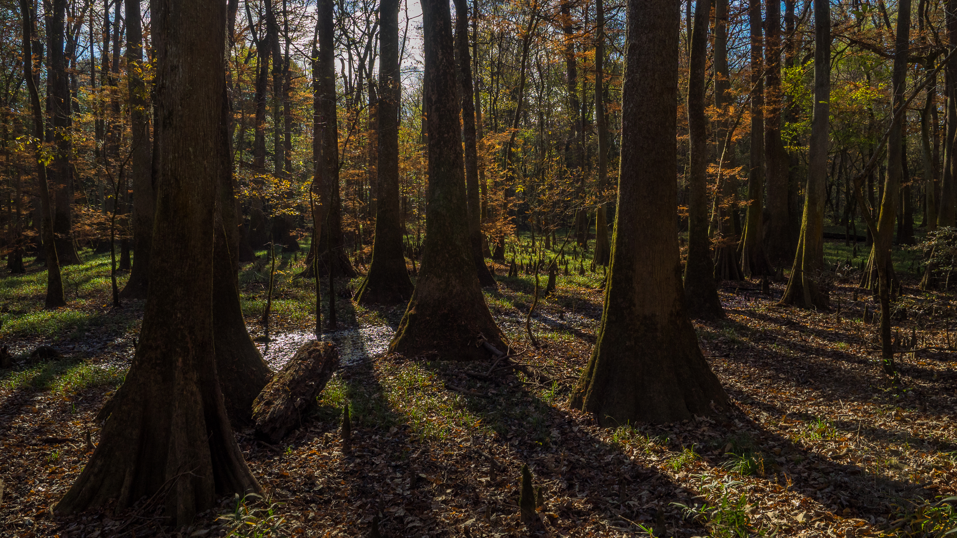
After a quarter mile or so you come to the bald cypress trees, groves of which will provide shade throughout the remainder of the day. Also, you will find the first of the “knees,” unusual pointed mini-trees that stand anywhere from 1-3 feet high. Since cypress trees have such a wide but shallow root structure, the knees help stabilize their entire system. Many of these cypress systems are considered “champion trees,” the largest of their kind in the nation.
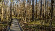
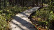
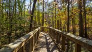
The Boardwalk is a 2.4 mile loop that allows easy access for all visitors to Congaree, offering an example of what the wilderness areas of the park have in store for those who set out on longer expeditions. The west side of the Boardwalk stands only about a foot above ground and may be regularly covered by water. The eastern side is elevated anywhere from five to 12 feet, enabling you to see the floodplain in action.
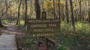
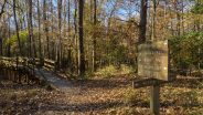
After three quarters of a mile, the Boardwalk makes a left turn, while the rest of the trail system continues on land into the wilderness. The first trail you will be on here, Weston Lake Loop Trail, is #3 and is blaze-marked as such. Most of Congaree is wilderness, a designation that protects its wild character, natural conditions, and opportunities for solitude. No mechanical objects are allowed in designated wilderness, preserving quiet, peace and serenity for wildlife, and for hikers. The only break in the silence is the occasional flyover of fighter jets from nearby Shaw Air Force Base.
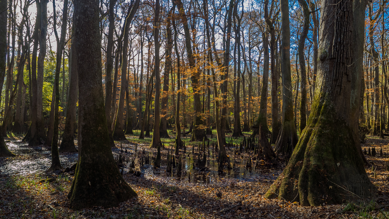
Bald cypress “knees” help to stabilize the root system of these giant trees that stand in water.
The Weston Lake Loop Trail is an inner loop within the wilderness that is 4.4 miles in total, and stays on the north side of Cedar Creek. Oakridge Trail (#4) is a 6.6 mile outer loop that crosses to the south side of Cedar Creek and offers additional exploration. Ken and I felt adventurous, so we mapped out a path that would take us most of the way around both loops, a hike of almost 10 miles.
We soon began to notice another of the forest differences of lowland South Carolina — spanish moss hanging from the branches and treetops of the giant oaks and beech. We were treated to a surprise as well, there was quite a bit of autumn leaf color still happening, even at this late November date.
As you walk into the backcountry, the swamp whispers stories of its abundant history. The first people inhabited the Congaree 10,000 years ago, hunting with stone arrowheads and gathering pawpaws. Europeans began to explore the area in the 1500’s bringing with them disease and war, stealing the land from the native peoples.
As you walk among the cypress groves growing in dry sloughs, you notice the occasional small meadows, remains of the slave period when the floodplain was developed for crops. During the Revolutionary War, the famous American general Francis Marion, known as the Swamp Fox, led a siege that broke the British hold on the land around Congaree.
In the next century, during the Civil War, slaves used the Congaree as a hiding place, even forming small communities. After the war, the freed people were able to buy farms in the “40 acres and a mule” program. As the turn of the century approached, a logging company bought most of the Congaree floodplain, hoping to score a fortune from the old growth oaks, cypress and pine. Instead, they discovered the frequently wet forest to be difficult and expensive to log, and gave up.
In the mid-20th century, the loggers tried again, but this time were stymied by a grassroots campaign to save the forest, led by journalist Harry Hampton. With bipartisan support, legislation was eventually passed to preserve this largest remaining old growth floodplain in the Southeastern United States, and in 1976 Congaree was given national park status.
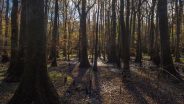
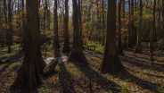
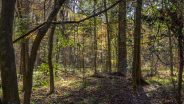
The Oakridge Trail is easy to hike, level and wandering. We were fortunate to catch it completely dry, not even damp. A park ranger at the Visitor Center told us before we started that mud is very common. The ground cover is mostly switch cane and river cane, quite common in the Carolina lowlands. In addition to the cypress, oak and beech, look for tupelo trees with their swollen trunks.
There is occasional blow down that must be navigated, courtesy of hurricanes Hugo in 1989, Matthew in 2016, and Irma in 2017. Some of it may be difficult for small children to get over, but lifting and carrying will solve that problem.
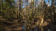
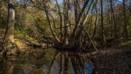
As we reached the eastern side of Oakridge Trail, we once again crossed over Cedar Creek and picked up the southern bottom of the Weston Lake Loop Trail, following Cedar Creek for the next mile and a quarter. We kept an eye out for river otters. Sightings are common along the creek bank, but not for us on this day. So we found a particularly scenic spot amid a cypress grove and stopped for lunch.
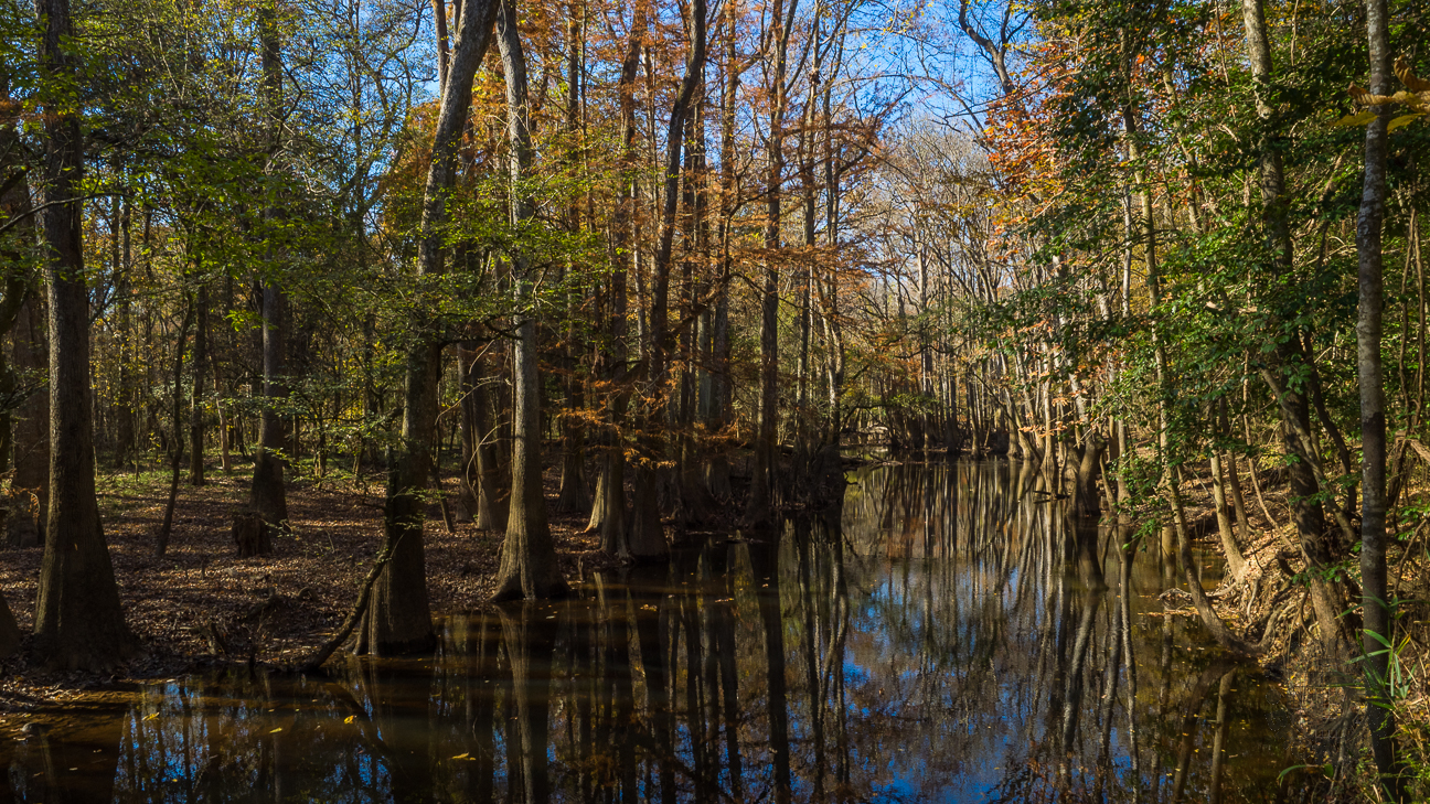
This particularly enticing view along Weston Lake Trail proved to be a delightful place for lunch and a rest.
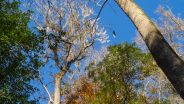
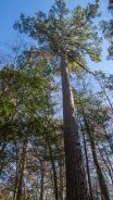
The impressive height of the Congaree forest canopy comes thanks to the extremely rich soil, the frequent flooding, and the southeastern climate offering a long growing season. The oaks and cypress average 130 feet here, and on the western side of Weston Lake Trail there are loblolly pines that scrape the sky 160 feet above.
These “champion” trees, however, remain at risk despite the protections that are now in place. Floods bring with them pollution. Climate change is altering plant growth and animal behavior, as well as weather patterns (for example, the more frequent high-wind hurricanes).
As we returned to the eastern side of the Weston Lake Loop, we hopped back on the Boardwalk to head over to the west side of the loop again to check out the massively tall loblollies, and Weston Lake. Once a bend in the Congaree River, Weston Lake is now what is called an oxbow lake, a U-shaped body of water that forms when a wide meander from the main stem of a river is cut off, creating a free-standing body.
I was struck by how the lake’s elevation is right there with the dry land. Walking along the lakeshore made it quite evident just how easy it is for all of this to flood. It probably isn’t a good idea to visit Congaree soon after an especially hard rain. The park ranger also told us that when the trees go dormant in winter, they stop drawing water from the earth. Therefore, the water table naturally rises, flooding the surface even if there hasn’t been rain. Amazing!
After viewing the lake and the champion pines, we headed back to the Boardwalk for the return to the Visitor Center. This eastern side of the Boardwalk is elevated, quite the work of engineering. We were impressed with the pylons, some steel, some wood, that support more than a mile of lumber.
Along the way we passed stands of dwarf palmetto, cousins of the cabbage palmetto, the South Carolina state symbol. There is also a large iron box on the right side of the Boardwalk that is a remnant of the rough and tumble moonshiner days when alcohol was banned by the government. There are also occasional snags, dead trees that are still standing. Hopefully when they fall they don’t crush the Boardwalk.
When we got back to the Visitor Center, we went inside once again to thank the rangers and volunteers for an awesome experience. The park infrastructure, and its trails, are trash free. We did not come upon any along the nearly 10 miles of trails we hiked. The restrooms are clean, the exhibits are informative, and the people are friendly and helpful. What more could you ask for? Oh, the park is free too.
There is plenty more to do at Congaree National Park besides hiking. There are two campgrounds for tent camping only. You can canoe the Congaree River and portions of Cedar Creek. Fishing and wildlife viewing are favorites of many. More than 1,000 varieties of butterflies and moths live here, and yes, there are spiders too.
In the spring and summer, look for wildflowers along the pathways, and fireflies and owls after dark. Really the only negative wildlife are the feral hogs who root the ground for food, damaging the native plants, and the historic sites. The ground near the sloughs showed ample evidence of their presence.
There are 25 miles total of maintained trails within Congaree National Park. Ken and I scratched the surface with our excursion. You can even bring your doggie with you — on a leash. The River Trail and the Kingsnake Trail are longer adventures that go deep into the backcountry of the park’s wilderness. I can assure you we will be back.
Gee, I almost forgot. When you arrive for your visit to Congaree, be sure to check the “skeeter meter” hanging in the breezeway outside the Visitor Center. It will tell you what to expect on that day from the pesky mosquitoes. There are six levels on the meter, ranging from “all clear” (which it was on our visit in late November) to “war zone.” You probably want to wear 10 pounds of repellent as well as netting on those days in the summer.


The following are paid links. As an Amazon Associate I earn from qualifying purchases.
 I am Jeff Clark, founder of Internet Brothers, producer of this blog, and passionate about hiking. I live in Western NC near the Blue Ridge and Great Smoky Mountains. Pisgah and Nantahala National Forests are just out my door, so the content will focus on these areas, but let me know what you would like to see on the site.


Copyright © 2011-2023 Internet Brothers. All Rights Reserved. ISSN 2324-6057
Designed by Elegant Themes | Powered by Wordpress | Logo by Design Aspirations

This post brought back some nice memories of trail walking in my days in Northeast Texas (Caddo Lake) and South Louisiana. Seen lots of cypress trees and boy, those in Congaree look like champions alright. Love the skeeter meter.