
Sometimes you have to work for the reward at the end of the trail. Hiking from Craggy Gardens to Douglas Falls is a prime example. You will descend 1,350 feet from the Blue Ridge Parkway to this 70-foot waterfall through a luscious forest of birch, maple, and beech, even enjoying old growth hemlock along the way. Expect a rough hike, as the terrain is very rugged in the Great Craggy Mountains. Hop rocks crossing various branches of Waterfall Creek that also have smaller attractive waterfalls of their own. What goes down, though, must come back up in the case of Douglas Falls. Save some energy because it’s a very strenuous climb back up to the Parkway. It was a cool summer day for this hike on Wednesday, August 6, 2014 beginning at 9:00AM and ending about 2:30PM. Our plan was to take the Mountains to Sea Trail from Craggy Gardens to its junction with the Douglas Falls Trail, then continue to the falls, returning the same way.
Hike Length: 7 miles Hike Duration: 5.5 hours
Hike Configuration: Down and back up. Groan. Blaze: White, yellow
Hike Rating: Difficult. Combines rugged terrain with strenuous climbing.
Elevation Gain: 1,770 feet Elevation Change: 1,350 feet
Trail Condition: Rough. Trail is extremely rocky and rooty. Three creek crossings may be dicey following a hard rain. Be on your toes at all times on this trail.
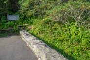
Starting Point: South end of Craggy Gardens Visitor Center parking.
Trail Traffic: We encountered one other hiker, going down as we were returning.
How to Get There: From any Blue Ridge Parkway access point, head to milepost 364.5. The Mountains to Sea Trail is at the south end (left) of the Craggy Gardens Visitor Center parking.
It was with some trepidation that I started this hike. I had always heard it is hard, really hard. Well, the only way to find out is to give it a try. You start on the famed, white-blazed Mountains to Sea Trail from the Craggy Gardens parking. A short hundred yards later, the trail splits with the left fork taking you to the heath balds high above the Parkway, and the right fork pointing to Douglas Falls. No looking back now.
Within less than a quarter mile you will come to another junction. Left turn for the Craggy Gardens Picnic Area, and right turn to Douglas Falls. You’re still on the Mountains to Sea Trail at this point. Now heading due north, and descending along the west flank of Craggy Pinnacle, you are likely to still hear the Harleys as they vroom past on the Parkway above.
You’re entering the deep forest now, one of mixed hardwoods including beech, maple and birch. The rhododendron are all around as always, and on this day in mid-summer we were treated to bee balm, St. John’s Wort, and lots of chickweed. The trail reputation I had read about is true. The tread is very rocky and there are many exposed roots just itching to snag your toe and cause a stumble. It was not as overgrown as I expected, but I did catch the occasional sting of a nettle leaf reaching out to be a nuisance.
About a half-mile down the trail you will begin an unexpected climb of about 200 feet as you go up and over first Big Fork Ridge, and then Porcupine Ridge. Remember this for the climb back up later as it is somewhat demoralizing giving back the hard earned elevation gain. At the one mile point, and just a little less than a third of the way to Douglas Falls, you will reach the last trail junction. Here, the MtS continues uphill to the right, and the yellow-blazed Douglas Falls Trail (#162) proceeds downward to your left. The descent becomes quite serious now, even entering a series of switchbacks following the junction.
The trees get considerably bigger as you enter several stands of old growth forest over the next couple miles. The first are of the hardwood variety including some monster birches that have trunks six feet wide. There are also two distinct stands of hemlock that will take your breath away with their magnificence. Somehow these amazing creatures have managed to avoid the blight of the hemlock woolly adelgid and continue to thrive.
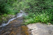
The rush of water in the forest will also now be your constant companion as you will make three crossings of various branches of Waterfall Creek. For us, each crossing was quite benign because there wasn’t much water, but beware the slippery rocks and heavier flow following a hard rain. Two of the three cross in the midst of prolonged slide waterfalls. Don’t be confused thinking one of these may be Douglas Falls and short yourself. Believe me, when you finally reach Douglas Falls you will know it.
The Great Craggy Mountains have formed one of the southern Appalachian rainforests that are common to this elevation. Drainages from the mountains high above are ubiquitous along the trail as the understory becomes thicker, the forest darker, and the tread more moist. This liquid nourishment is conducive to growing and the flora are quite prominent the farther down you go, particularly the bee balm.
I’m told to watch out for yellow jackets dwelling in all the rocks along this trail, but we were fortunate to be traversing it on an especially cool day for August, so the critters chose to remain in their holes waiting for afternoon heat. In fact, we didn’t even have to break out the repellent at all. Even the gnats chose to leave us alone.
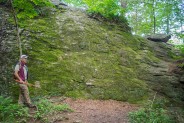
You will know you’re getting close to Douglas Falls when you come upon a house-sized rock outcropping straight ahead of you on the trail. Surrounded by old growth hemlock, this area of the forest is quite remarkable for the size of its objects. On the back side of the outcrop is a clearing with an ugly fire ring detracting from the otherwise beautiful nature of the scene. Around the outcrop the trail takes a northeasterly turn, descends steeply, then makes a hard u-turn to the southwest.
You will now begin to hear the tell-tale sound of an obvious large waterfall, and you’re no more than 10 minutes from Douglas Falls. Approaching the falls you will notice seemingly dozens of trails fanning out in every direction like an open hand. I suppose it doesn’t really matter which one you take, as they all eventually end at the base of the falls. It’s just a shame that the “volunteers” found the need to stray from the original trail and destroy the forest. It took us a total of about 2 hours, 20 minutes to reach the base of Douglas Falls.
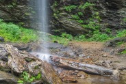
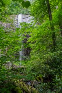
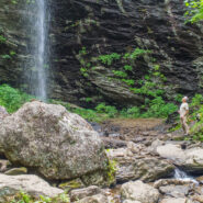
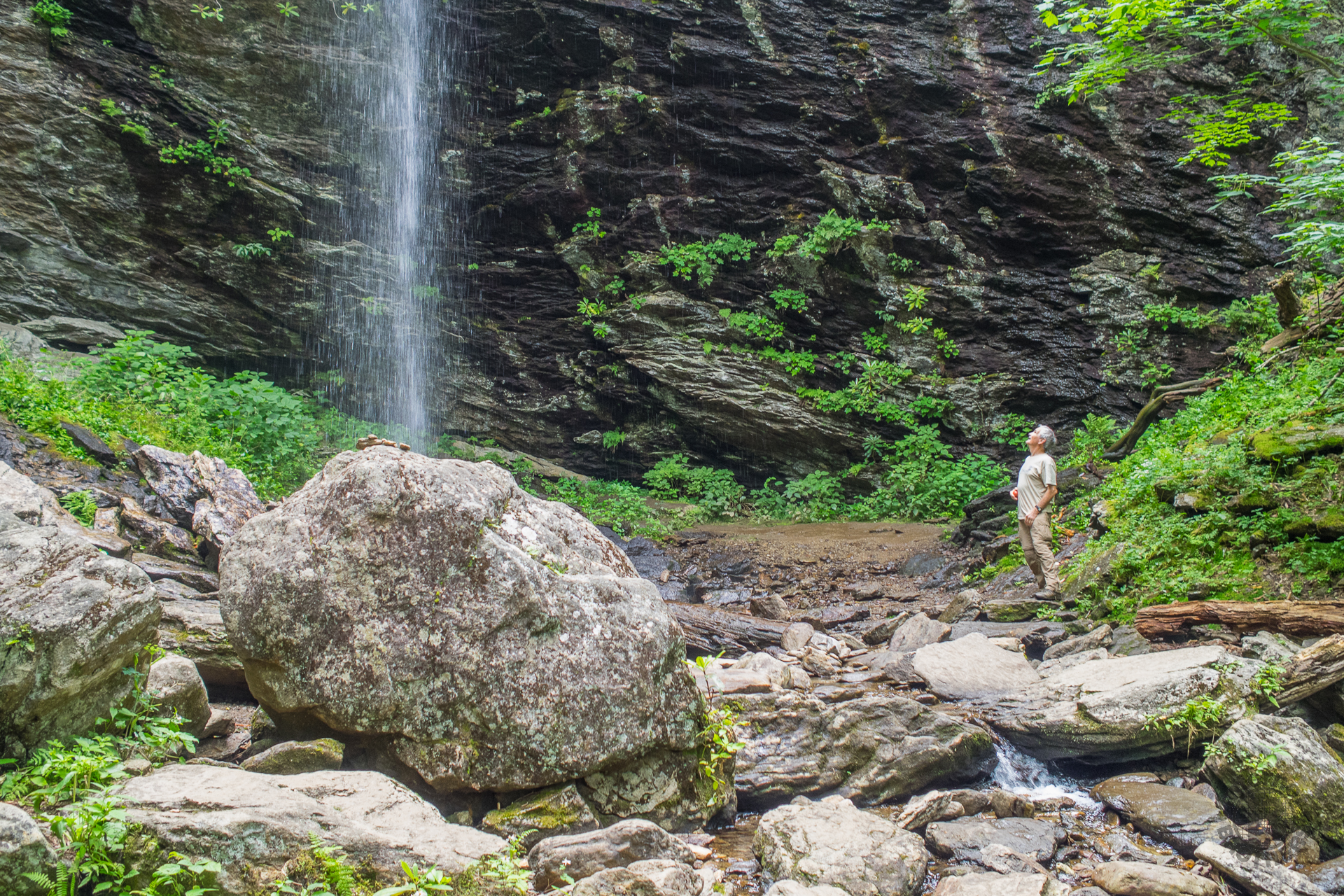
What you are presented with is most definitely worth the hard descent. The plunge of Douglas Falls from above is at least seventy feet. It free-falls over a massive wall, that combined with the surrounding hillside, forms a sort of natural amphitheater. The base of the granite wall is recessed from the precipice, so it is quite easy to view the plummeting water from every angle. You can walk behind the falls or directly underneath if you so desire. There is no plunge pool. The water immediately continues down Waterfall Creek for its eventual meetup with Carter Creek.
Set back about 50 feet from the landing zone is a perfectly placed log that just screamed LUNCH at us. It’s like having box seats to a major league baseball game, except in this case the show in front of us was the stately Douglas Falls. Put this one in my top ten of “best places to enjoy your lunch.”
Unfortunately on this day, the waterfall was more of a shower than a deluge, but we could see from the wetness on the rock wall that this can be a major tumult when the conditions are right. In fact, I suspect this log where we were safely sitting 50 feet away is likely inundated during spring runoff. Following a most enjoyable meal we decided to explore the amphitheater.
After completely circling the falls, I think my favorite view was from the right side. From there you have the best look at the total largeness of the scene. The depth of the spray from the descent was probably 15 feet, even on this low volume day, and it falls at least 10 feet from the recessed cavity at the base of the wall.
High above the base on the left side is an ominous looking cave. I didn’t go up that far, but my companion said the unmistakable tracks of black bear were all over the entrance. He needed eyes in the back of his head to watch the cave entrance as he turned to photograph the plunge of Douglas Falls. Fortunately for him, no bears decided to come answer the door.
There’s a somewhat odd lean-to constructed near the lunch log. I suppose someone had a lot of time on their hands, or got caught in an unexpected thunderstorm. There is also another trail that heads to the east and is a method of accessing Douglas Falls from below, rather than from above as we did. You can get there from the little town of Barnardsville. In fact, there is a whole series of remote trails that surround the Walker Creek and Walker Ridge area of Pisgah National Forest. Ah, more trails for more days.
We stayed at the falls for about 45 minutes, and then finally decided we had to man up and begin the ascent. I’ve always preferred trails that go up first to the destination, and then come back down at the end. For me anyway, I prefer to do the climbing early on when I still have plenty of energy. Hikes like this one where you get fatigued on the descent, but then still have to climb 1,350 feet back out make me weary just thinking about it.
Sometimes you just have to put your head down, put one foot in front of the other, and trudge on. Based on the time of descent, we estimated it would take us about three hours to get back to the top. So we steeled ourselves for a three hour climb and pressed forward. The first half mile is pretty hard, but then the grade upward becomes considerably more moderate.
Some days you’re just stronger on the trail than others, and thank goodness this ascent was one of those for me. Sure, we stopped every half hour for a 3-5 minute break, but I was surprised how well we knocked out the mileage. We passed the only other hiker we saw all day right about where the Douglas Falls Trail rejoined the Mountains to Sea. He explained this was his third attempt at this trail, that his first two tries he had turned back early. He was determined, however, to go all the way this time. We told him of the landmarks to expect and wished him well with his adventure.
I was totally pleased when we popped back out on the Blue Ridge Parkway just two and a half hours after leaving Douglas Falls, a full half hour less than our estimate. Yes, I was definitely tired, but it was that good tired, one you feel after a job well done. That trepidation I’d experienced on this spot early in the morning? Totally unnecessary.
OK, let’s summarize this. First off, let me concede that this is a hard hike. However, I would not say it’s as difficult as I expected. There’s no question the terrain is extremely rugged. There’s no question the trail tread is rough; very rocky and hard on the feet. You have to constantly be on your guard to avoid slips, snags and falls from the roots and uneven ground. The reward that Douglas Falls presents at the bottom of the trail is most definitely worth the exertion. If you’re in pretty good hiking shape, even that climb back up isn’t so bad. I’ve certainly done worse… even just recently.
August may not necessarily be the best time to take on this hike. We were fortunate that it was an unusually cool day. You may want to consider tackling Douglas Falls either in Spring when the water is likely to be flowing freely, or in October when you can enjoy the coolness of the air and the changing leaves that are a harbinger of Fall. Keep in mind, though, that those are also likely to be the two times of year when Craggy Gardens would be most crowded. People love the rhododendron bloom and their leaf peeping.


The following are paid links. As an Amazon Associate I earn from qualifying purchases.
 I am Jeff Clark, founder of Internet Brothers, producer of this blog, and passionate about hiking. I live in Western NC near the Blue Ridge and Great Smoky Mountains. Pisgah and Nantahala National Forests are just out my door, so the content will focus on these areas, but let me know what you would like to see on the site.


Copyright © 2011-2023 Internet Brothers. All Rights Reserved. ISSN 2324-6057
Designed by Elegant Themes | Powered by Wordpress | Logo by Design Aspirations


One of my favorite walks. May not be true “old growth” but this section of the national forest hasn’t been disturbed in a long while resulting in incredible biodiversity. A great trail for spring ephemerals and fall mushrooms. The trail difficulty does have the benefit of keeping the through traffic low. Walking this trail you can merge into the forest undisturbed to the point where you welcome human contact again. A good blog – hopefully it brings just enough traffic to keep it maintained!
I’m currently planning a Pisgah trip and this looks like a great hike! I had a couple questions that you hopefully can answer!
1) Driving to Pisgah is usually a half day trip for us (we’re based in Wilmington, NC), once we get to the bottom near the falls, are there any good campsites that would enable us to hike down, stay the night, then hike back out the next day? You mentioned the obvious bear activity and that kind of worried me…
2) I saw some pretty big slabs of rocks in the photos. We’d love to do some bouldering/light rock climbing and I was wondering if you noticed any spots that would be suitable to pull off the trail and take a break to climb for a little bit. (Not sure if climbing is your thing or not, or if you’d notice such things).
Thanks for making such a great blog, I’ve used it to plan several trips for myself and my fiancée!
Hi Jesse, thanks for the kind words.
There are a few primitive campsites, although there is alternate access to Douglas Falls from the bottom through the town of Barnardsville. There are other trails on the northeast side of the falls on the forest road that comes from the town. I’m sure the forest rangers could tell you of any camping that would be available.
As for climbing, the only rock really high enough would be the falls itself. I wouldn’t however call it light.
Thanks for this post! My girlfriend and I did this hike this past Saturday. I was such a treat and there were only a few other people around the waterfall. Side note: I was shocked by the number of unprepared people we saw near the beginning of this hike. I encouraged two couples to turn around since they had no water, no map, and poor shoe choices. I hike nearly every weekend and this was the worse case of badly prepared hikers I’ve ever seen.