
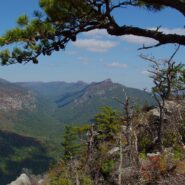
Most of the attention in Linville Gorge is focused on the northern features. There are more trails, higher peaks, and family recreation areas. But the south gorge is every bit as compelling and beautiful, with spectacular panoramic views up the gorge and westward to Pisgah National Forest and the Blue Ridge Mountains. Shortoff Mountain is a thousand feet lower than its...
Learn More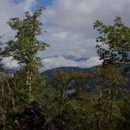
Kind of an unusual name for the mountain this trail is named after, but it is at 5,200 feet, so the snow comes earlier in the season, and more frequently than in the valleys below. North of Asheville, NC on the Blue Ridge Parkway, this hike is in the Craggy Gardens area. There are splendid views of the Great Craggy Mountains and the Black Mountains from the three summits...
Learn More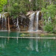
I first visited Hanging Lake in 1982. I heard this summer that the federal government had designated the site a National Natural Landmark, so it piqued my curiosity to take a look again. Glenwood Canyon is a rugged and remarkably scenic place with tall red sandstone cliffs rising 1300 feet on both sides of the Colorado River. The trail up the canyon to the lake follows...
Learn More
Flat Laurel Creek is in the area just north of the Pisgah Ridge and in between the Shining Rock and Middle Prong Wildernesses. It drains from Sam Knob and Little Sam Knob and runs to the West Fork of the Pigeon River. The trail that bears its name starts at the headwater and travels 3.7 miles around the west side of Little Sam until it meets Hwy. 215 and joins the...
Learn More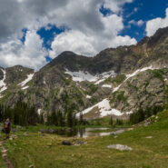
Missouri Lakes Basin in the Holy Cross Wilderness is one of the most beautiful areas in Colorado for hiking and camping that I have experienced. It is an area of lakes and streams filled with trout and large glacial boulders, surrounded by lush forest and tundra, and the gnarly cliffs of the Sawatch Range in the Holy Cross Wilderness. There is some of just about every...
Learn More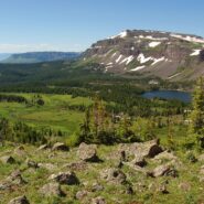
Flat Tops Wilderness is the second largest U.S. Wilderness Area in Colorado. Located near the towns of Yampa and Steamboat Springs, it is 235,214 acres, with 38,870 acres in Routt National Forest and 196,344 acres in White River National Forest. The area is named for a series of flat top mountains that dominate the landscape. This is sub-alpine and alpine terrain with...
Learn More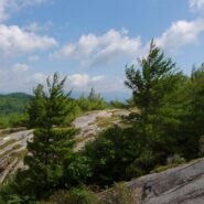
This is an extension of the trail report about the Panthertown Trail System in Nantahala National Forest from a previous post. When we explored Panthertown last November, we knew very little about it and kind of fumbled our way along the myriad of trails. Since, we have studied the trail system map and had a plan that included going to the top of Big Green Mountain, a...
Learn More
Looking at a trail map or topographic map, the area of this hike within Shining Rock Wilderness can be somewhat confusing. There is the Greasy Cove Prong, a creek that runs off of the Grassy Cove Ridge. The trail is called Greasy Cove, but it starts/ends at Grassy Cove Top. I think the guys who named the area may have had a touch too much huckleberry wine. Regardless of...
Learn More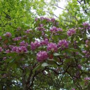
This a continuation beyond the hike described in the Black Balsam Knob and Tennent Mountain trail report. The Art Loeb Trail continues down the north side of Tennent Mountain to Grassy Cove. There it meets the Ivestor Gap Trail for a lengthy hike into Shining Rock Wilderness. The area was named by the Cherokee for the large deposits of quartz found along what has become...
Learn More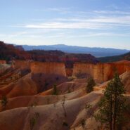
Bryce Canyon National Park is in the southwestern corner of Utah, near Zion and Cedar Breaks. Most of the park is above 8000 feet elevation, so the air is clear and the views long. Bryce Canyon is famous for its odd, fanciful geologic formations known as hoodoos and the myriad of color found in the sandstone. The Fairyland Loop Trail is one of the best kept secrets about...
Learn More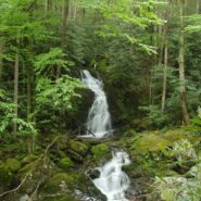
Sitting right along the Tennessee/North Carolina border in the far northeast corner of Great Smoky Mountains National Park is an enjoyable section of forest and creek side trails that navigate the Big Creek area of the park. The Appalachian Trail goes through the area, as does the Benton MacKaye Trail, named for the planner of the AT. There are mountains in the region as...
Learn More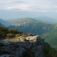
Linville Gorge runs north to south and has two entirely different rims. Trails on the west rim start on top and go down into the gorge to Linville River. Trails on the east rim go to a series of mountains that offer views into the full length of the gorge, and of the North Carolina Piedmont to the east and the Black Mountains to the west. There are a couple downward...
Learn More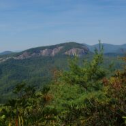
Coontree is a popular picnic area for familes along Davidson River in Pisgah National Forest, NC. What most of them probably don’t know though, is that there is a nice hiking trail just across Hwy. 276 from the parking area. It is very easy to get to, as it is only five miles from the crossroads in Brevard, NC. The trail itself is a loop with a connector at the top...
Learn More
This hike has a reputation for being one of the best in the country, for good reason. The scenery, the environment, the trail (or lack thereof) are all unique and awe inspiring. You are actually hiking in the Virgin River through what is known as The Narrows in Zion Canyon. Steep sandstone cliffs rise a thousand feet or more on both sides of the river. The colors in the...
Learn More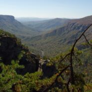
Formal protection of the Linville Gorge began in 1952, when the land was purchased with funds donated by John D. Rockefeller, Jr. When the Wilderness Act was approved by Congress and signed into law by President Johnson in 1964, the Linville Gorge Wilderness became one of the first formally designated Wilderness areas of the new National Wilderness Preservation System....
Learn More
Panthertown Valley lies in Nantahala National Forest near Cashiers and Lake Toxaway, North Carolina. The Forest Service, along with the Friends of Panthertown, have created a trail system in combination with old logging roads that lead to waterfalls, cliffs, bogs, deep forest and spectacular overlooks of the surrounding valley. Panthertown has been designated a Blue...
Learn More
This hike is in one of my favorite areas of Pisgah National Forest along the Blue Ridge Parkway in western North Carolina. It lies in a little corner between Middle Prong Wilderness and Shining Rock Wilderness where the mountain tops are bald and exceed 6000′. This hike occurred on March 24, 2011 beginning at 10:00AM and ending about 3:00PM. The goal on this day...
Learn More I am Jeff Clark, founder of Internet Brothers, producer of this blog, and passionate about hiking. I live in Western NC near the Blue Ridge and Great Smoky Mountains. Pisgah and Nantahala National Forests are just out my door, so the content will focus on these areas, but let me know what you would like to see on the site.


Copyright © 2011-2023 Internet Brothers. All Rights Reserved. ISSN 2324-6057
Designed by Elegant Themes | Powered by Wordpress | Logo by Design Aspirations