Bryce Canyon National Park is in the southwestern corner of Utah, near Zion and Cedar Breaks. Most of the park is above 8000 feet elevation, so the air is clear and the views long. Bryce Canyon is famous for its odd, fanciful geologic formations known as hoodoos and the myriad of color found in the sandstone. The Fairyland Loop Trail is one of the best kept secrets about Bryce Canyon. Located at the far northern tip of the park, most of the tourists blow right past Fairyland on their quest for car accessible Bryce overlooks. So Fairyland is a hikers dream. This hike occurred on July 18, 2009 beginning at 7:00AM and ending about 12:15PM. Our plan was to be at the trailhead at dawn and traverse the loop in a counterclockwise direction, starting with a climb up the rim trail, followed by the downward plunge to Tower Bridge, and concluding with the climb out of Fairyland Canyon back to the trailhead at Fairyland Point.
Hike Length: 8 miles Hike Duration: 5.25 hours
Hike Rating: Moderate, some strenuous Blaze: None
Elevation Gain: 2309 feet Hike Configuration: Loop
Trail Condition: Excellent, well maintained Starting Point: Fairyland Point
Trail Traffic: Nowhere near as crowded as the popular trails through the Bryce Amphitheater, we still encountered about 30 other hikers on this well kept secret.
How to Get There: The Fairyland Point Trailhead access road is located just north of the Park Visitor Center and Entrance Station outside the park boundary. If you reach the Visitor Center you have gone too far. The access road is located three miles south of Ruby’s Inn on Highway 63. Turn left on the Fairyland Point access road, go one mile to the parking area at the Fairyland Point trailhead.
View Fairyland Loop Trail, Bryce Canyon National Park in a larger map
First a few warnings about hiking in Bryce Canyon. The park elevation is between 7000 and 9000 feet. It’s up there. So if you are arriving from your home in a significantly lower elevation, it is a good idea to spend at least a full day doing less strenuous activities to acclimate your body to the elevation. Altitude sickness is no fun. Second, even though this is in the mountains, the region is quite arid. It is a high desert. You will discover the trails are dry and dusty, especially in summer, so please bring plenty of water with you for this eight mile hike. It is recommended to have at least a liter for every two hours of hiking. This trail is highly exposed to sun and wind, so sunscreen, sunglasses and a broad-rim hat are recommended. Additionally, Bryce Canyon has the highest lightning strike hazard in Utah. Take approaching weather very seriously and plan your travel time accordingly.
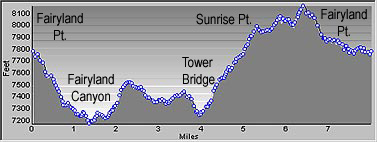
 Apparently most people hike the Fairyland Loop in the clockwise direction. However, my brother and I took a look at this elevation profile from the National Park Service and thought it might best be done the other way. We thought the very steep section between Tower Bridge and Sunrise Point might be preferable in a downward fashion. As I will be describing the hike, we traveled from right to left on this profile graphic.
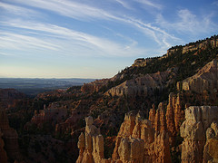
We arrived at the Fairyland Point trailhead right at dawn, so the color on the sandstone was already dancing for our eager cameras. The trail climbs and follows the rim above the canyons for the first 2.5 miles. It starts out going around the edge of Boat Mesa, an 8000′ formation of harder sandstone that has managed to avoid the erosion that creates the famous hoodoos. The trail is very close to cliff edges and the stability of the ground can be iffy. After all, erosion is what created this marvelous scenery. So be wary and careful if you peer over the edge. The early morning light on the hoodoos in the canyon was stunning, as evidenced by the photo at the top of this post.
As we reached the top of the rim, there was a marvelous view to the west of the Table Cliffs in the distance. In the foreground was pinyon pine, wildflowers and open grass. Quite different from the juniper and bristlecone pine we would encounter in the canyons. Two miles along the rim and we began hearing the sounds of campers doing their morning camper things as we passed the North Campground. There were a lot of folks scurrying about, but we were already two miles into our hike and they hadn’t even had breakfast yet. The early bird catches the amazing view at Sunrise Point, which was the next landmark along the trail. It looks down Campbell Canyon and far beyond to Dixie National Forest.
 Just before Sunrise Point, the Fairyland Loop Trail takes a left turn and begins heading downward. By now it was beginning to warm up so I unzipped the legs from my convertible hiking pants and stuffed one of my core layers in the pack. Shorts and a tee were now the fashion as I expected it to get considerably warmer on this mid-July day. The next 1.5 miles winds quite steeply down into Campbell Canyon. As we were pounding our knees on this steep trail, I was thinking to myself we made the right decision going this direction. I wouldn’t want to climb this later in the morning when it was hotter. The forest of pinyon and juniper eventually gave way to dry dirt and hoodoos. It’s hard for vegetation to get a root hold.
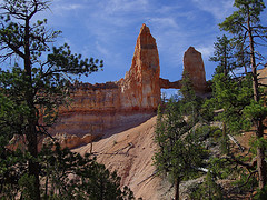
We passed an amazing stand of colorful hoodoos known as the China Wall. It dominated the view along the trail for quite awhile. When we reached the bottom of the canyon we could see evidence of Campbell wash, a drainage channel that runs through Campbell Canyon. This is the halfway point of the hike and there is a spur trail through a small forest that drinks from the sparse water provided by the wash. About 200 yards up the spur is Tower Bridge, a natural arch with spire-like “towers” on either end of the arch.
 There are some well placed logs in the shade beneath Tower Bridge that made an ideal spot for an early lunch, and to rest the legs and lungs before beginning the upward part of the hike. As we were chowing down, a couple came down the trail who were tackling the loop the opposite direction from us. They asked how steep the climb back up to Sunrise Point was. Not wanting to break their hearts and their will, we responded that they would do just fine. They looked young and fit.
The trail begins to climb out of Campbell Canyon with a series of switchbacks that took us up and over the next ridge. On the other side was a spectacular surprise. Although very windy while we were standing on the precipice, there is a fabulous view of Fairyland Canyon and the iconic Sinking Ship Mesa beyond the canyon. We had to be very careful on the narrow ridge edges because of both the wind and erosion, but this was the highlight of a terrific hike. There are hundreds of hoodoos visible above, below, to the left and right… every which way but up. And oh the up. The sky in Bryce Canyon is some of the clearest in the country. People come from hundreds of miles just to stargaze at night. As we were surveying this beautiful landscape, a lone hiker came up from in front of us carrying nothing but a gallon jug of water. At least he had that. No hat, no shirt, no shades.
Best HikeThe rest of the hike is a steady, gradual climb up the ridge that follows the northern branch of Campbell Wash and parallels Fairyland Canyon. It is longer, but a lot less steep than the climb from Tower Bridge to Sunrise Point, so I’m glad we chose to take this hike counterclockwise. The canyon floor is heavily vegetated and the trail crosses the wash three different times. The trail traffic picked up considerably going the opposite direction from us as those late rising campers began to strike out and explore. As we neared the top, we could again see Boat Mesa to our left and the canyon rim above. We reached Fairyland Point in just over five hours, stopping for lunch and lots and lots of pictures. The views were awe inspiring… indeed a fairyland. I can’t imagine any of the trails in Bryce Amphitheater being any better than the Fairyland Loop. I highly recommend it and I rate it as one of the best hikes I have done out west.
My brother put a 6 minute video together.
[youtube http://www.youtube.com/watch?v=hslT7Kfkrbk&w=640&rel=0]
The following are paid links. As an Amazon Associate I earn from qualifying purchases.
Hi Jeff,
Wonderful story and metaphor you wrote on my last post. Thank you.
Looks like we have some similar interests in writers as well as wild places. Great post here. This is one area down south we are so wanting to wander more in… All in good time.
Doesn’t Bryce have the most amazing hidden beauty there…
DSD
Yes DSD, indeed it is gloriously beautiful. Not just the hoodoos, but some of the upper reaches of the park above 9000 feet are just as green as can be. I can never get enough of the quintet of national parks in southern Utah.