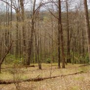
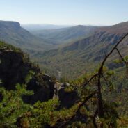
Hidden deep within the Mills River area of Pisgah National Forest, the Pilot Cove/Slate Rock Creek loop trail is primarily a water feature hike. There are two notable waterfalls and several cascades on Slate Rock Creek, and views of Slate Rock through the trees. We encountered several creek crossings (some wading, some with log bridges), and a relatively young forest. This hike occurred on April 14, 2011 beginning at 10:45AM and ending about 2:15PM. The plan was to take the Pilot Cove Trail through Pilot Cove then up on the rim overlooking...
read moreCold Mountain gained national attention following the publishing of Charles Frazier’s Civil War era novel in 1997. Western NC hiking enthusiasts have known of its appeal for much longer. Cold Mountain is a real mountain that stretches 6030′ and is located in the Shining Rock Wilderness and Pisgah National Forest in North Carolina. You can reach the spur trail to the summit on the Art Loeb Trail; section 3 from the south, or section 4 from the west. The trail was named for a member of the Carolina Mountain Club who devoted much of...
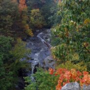
read moreMost people think of Skyline Drive, or the mountains that overlook Shenandoah Valley when they imagine Shenandoah National Park in Virginia. But my favorite hike during a visit in early autumn was the Cedar Run, Whiteoak Circuit that starts at milepost 45.6 on the SD. It’s a brute of a hike, but well worth the effort exerted for the combinations of creeks and streams, waterfalls, deep forest and wildlife. This is one where you might want to consider your physical condition. No matter which direction you go, there is going to be a very...
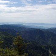
read moreOne of the enduring pleasures in the Tennessee portion of the Great Smoky Mountains National Park is scaling the 6,593 feet of beauty that is Mt. LeConte. It isn’t quite the highest mountain in the park, but it is by far the tallest hike from its base. The summit is so popular, there are five distinct trails to the top, varying in distance and difficulty. My favorite is the Alum Cave Trail. It is the shortest, at five miles to the summit, but as a result it is also the steepest and most difficult. At the top are cabins known as LeConte...
read moreFormal protection of the Linville Gorge began in 1952, when the land was purchased with funds donated by John D. Rockefeller, Jr. When the Wilderness Act was approved by Congress and signed into law by President Johnson in 1964, the Linville Gorge Wilderness became one of the first formally designated Wilderness areas of the new National Wilderness Preservation System. Wonderful news for future generations, as this wilderness that covers more than 12,000 acres will remain in the same pristine condition for centuries to come. The area is...
read morePanthertown Valley lies in Nantahala National Forest near Cashiers and Lake Toxaway, North Carolina. The Forest Service, along with the Friends of Panthertown, have created a trail system in combination with old logging roads that lead to waterfalls, cliffs, bogs, deep forest and spectacular overlooks of the surrounding valley. Panthertown has been designated a Blue Ridge National Heritage Area. This hike occurred on November 18, 2010 beginning at 9:00AM and ending about 3:00PM. We did not have a particular hike itinerary because only one of...
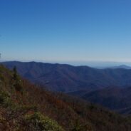
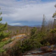
read moreThe Middle Prong Wilderness is west of North Carolina Hwy. 215 and north of the Blue Ridge Parkway. It is named after the Middle Prong of the Little Pigeon River that runs through the heart of the wilderness. This is remote territory in the high country near 6000 feet. Prepare yourself for heavy breathing — from exertion, and from natural beauty. Buckeye Gap Trail takes you to Middle Prong, then Haywood Gap Trail follows the river back up the drainage. This hike occurred on November 5, 2010 beginning at 8:00AM and ending about 2:00PM....
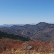
read moreBetween North Carolina Scenic Hwy. 276 and the Pisgah Inn is Fryingpan Mountain, one of a series of mountains along the north side of the Blue Ridge Parkway that help form the Pisgah Ridge. It sits at mile 410 on the parkway. A unique feature of Fryingpan is the 1940s era fire tower that affords spectacular views of the surrounding Blue Ridge. The tower is on the National Register of Historic Places. This hike occurred on February 11, 2011 beginning at 10:00AM and ending about 2:00PM. Our goal on this day was to start at the Mt. Pisgah Trail,...
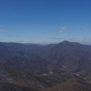
read moreThis hike is in one of my favorite areas of Pisgah National Forest along the Blue Ridge Parkway in western North Carolina. It lies in a little corner between Middle Prong Wilderness and Shining Rock Wilderness where the mountain tops are bald and exceed 6000′. This hike occurred on March 24, 2011 beginning at 10:00AM and ending about 3:00PM. The goal on this day for the two of us was to climb to the top of 6050′ Sam Knob, a bald or treeless mountain with a 360 degree view from its double summit. Following that, we were going to...
read moreThis park sits right on the cliff’s edge of the Blue Ridge Escarpment that drops down from the mountains in western North Carolina to the upcountry of South Carolina. The park is more than 3,000 acres of trails, lakes, cabins and camping. Table Rock State Park is located 12 miles north of Pickens, SC. This hike occurred on February 2, 2011 beginning at 9:30AM and ending at 2:30PM. Three of us set out with a goal of climbing the nearly 2000 feet to the summit of Table Rock Mountain on the Table Rock Trail. Near the 3124′ summit...
read more I am Jeff Clark, founder of Internet Brothers, producer of this blog, and passionate about hiking. I live in Western NC near the Blue Ridge and Great Smoky Mountains. Pisgah and Nantahala National Forests are just out my door, so the content will focus on these areas, but let me know what you would like to see on the site.


Copyright © 2011-2023 Internet Brothers. All Rights Reserved. ISSN 2324-6057
Designed by Elegant Themes | Powered by Wordpress | Logo by Design Aspirations