
This park sits right on the cliff’s edge of the Blue Ridge Escarpment that drops down from the mountains in western North Carolina to the upcountry of South Carolina. The park is more than 3,000 acres of trails, lakes, cabins and camping. Table Rock State Park is located 12 miles north of Pickens, SC. This hike occurred on February 2, 2011 beginning at 9:30AM and ending at 2:30PM. Three of us set out with a goal of climbing the nearly 2000 feet to the summit of Table Rock Mountain on the Table Rock Trail. Near the 3124′ summit there are views of Table Rock Reservoir and Caesars Head, Slicking Falls, as well as much of the South Carolina upstate. The trail returns the same way.
Hike Length: 7.2 miles Hike Duration: 5 hours
Hike Rating: Difficult Blaze: Red
Elevation Gain: 1964 feet Hike Configuration: Up and back
Trail Condition: mostly good, some roots Starting Point: Nature Center
Trail Traffic: We did not see any other hikers on this trail the entire duration.
How to Get There: Table Rock State Park is on S.C. Hwy. 11 near the Greenville-Pickens county line. Enter at the west gate, go past the campground and follow the signs to the Nature Center. Park in the lot across from the Nature Center and cross the road. The trail is behind the Nature Center. Please fill out the hiker registration form at the kiosk. It’s for your safety.
View Table Rock Trail, Table Rock State Park, SC in a larger map
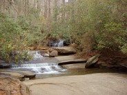
Important South Carolina state parks require a day use fee. Before you go to the trailhead, be sure to stop by the park Visitor Center on Oolenoy Lake and pay your $2.00 fee. They will give you a placard to hang on the rearview mirror of your car. This hike starts at the Nature Center at the end of W. Gate Road. The first 1/2 mile has numerous nicely maintained stone and log steps as it follows Carrick & Green Creeks on a steady steep climb. There are several 5-10 foot waterfalls that help set the mood for this beautiful creek-side stroll through the hardwood forest. We were very impressed with the trail maintenance, indicating the $2.00 fee is being well spent.
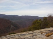
For the next mile the trail climbs steeply and leaves Green Creek. We passed by a large boulder field with stones as big as a house. The woods are very lovely and quiet through this stretch; good thing, because it took my mind off my burning lungs and legs. At 2400′ elevation we reached the halfway point; the Civilian Conservation Corps Trail-side Shelter. The view is very nice here of Pinnacle Lake and the SC upcountry. It’s a good spot for pictures. The next milestone came at 2.1 miles when we reached Panther Gap. Here the trail forks with access to the left to Ridge Trail that goes 1.9 miles to Pinnacle summit. We took the right fork to continue our climb up Table Rock Mountain. The next 1/2 mile is a very steep slog through more granite boulders.
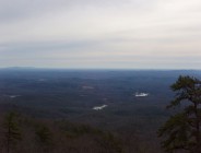
 At the 2.6 miles mark we arrived at Governor’s Rock, a giant granite outcrop. There are carved steps in the granite to help ascend this extremely steep section. Governor’s Rock sits at 2800′ elevation along the trail. From here we could see Pinnacle Mountain, Hickory Nut Mountain, and Sassafras Mountain, the highest point in South Carolina. This is another great spot for picture taking. Like many of the large granite mountain tops in the Blue Ridge, there are multi-colored mosses that grow and cling to Governor’s Rock no matter the season.
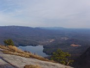
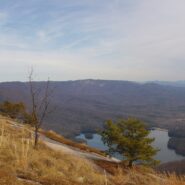
 It’s another 300 feet up and .6 mile to the summit of Table Rock Mountain, but this isn’t the end of the trail. There is a sign on the trail to designate the summit, but now we started heading down the other side to the overlooks. There are two outstanding view points. The first is 700 feet past the summit, looking across the gorge to the 400 foot cascade of Slicking Falls. We stopped for lunch at this point and watched the waterfall for 20 minutes. The trail ends 1/3 mile past the summit with a stunning view across Table Rock Reservoir to Caesars Head State Park on the other side. The photo at the top of this post is the view from the end of the trail. Be extra careful near the drop-offs. These overlooks are on sheer cliffs. It is a long way down!
The return trip was back the same way we came. We had the option of taking the Ridge Trail fork to Pinnacle Mountain summit, but we were already a bit tired. The extra 3.8 miles would have been a bit too much. We completed the full 7.2 miles up and back in right at five hours. It can be done in less, but we stopped for lunch and breaks. This is a pretty strenuous humper of a hike that tested our lungs and legs. On this day, we won.


The following are paid links. As an Amazon Associate I earn from qualifying purchases.
 I am Jeff Clark, founder of Internet Brothers, producer of this blog, and passionate about hiking. I live in Western NC near the Blue Ridge and Great Smoky Mountains. Pisgah and Nantahala National Forests are just out my door, so the content will focus on these areas, but let me know what you would like to see on the site.


Copyright © 2011-2023 Internet Brothers. All Rights Reserved. ISSN 2324-6057
Designed by Elegant Themes | Powered by Wordpress | Logo by Design Aspirations
Thanks for the great hike report. I’m coming up tomorrow night and will be tackling Table Rock first thing Friday morning. I might squeeze in Sassafras as well if time and energy permits.