The Tanglefoot Trail is Mississippi’s longest rails-to-trails conversion, a ten-foot wide asphalt multi-use trail that runs 43.5 miles through the foothills of the Appalachian Mountains in the Mississippi Hills National Heritage Area.
Visitors will experience a bit of local history as they pass through fields, forests, meadows, and wetlands along the path of the Chickasaws and Meriwether Lewis, later the route of a railroad built by Col. William C. Falkner, great-grandfather of Nobel Prize-winning author William Faulkner.
The Tanglefoot Trail is a former railroad line owned and operated by the GM&O Recreational District of North Mississippi. The Trail extends from Houston to New Albany, Mississippi.
Whistle stops serve as entrances to the trail in between larger municipalities and provide restrooms, water fountains, shelters with picnic tables, and parking. Interpretive signage for historic sites along the trail are being developed.
This trail first blazed by Indians was again followed by early explorers, Hernando De Soto and later, Meriwether Lewis. Ishtehotopah, the last Chickasaw king, built his home nearby. As Union troops made their way south, Col. Benjamin Grierson followed the same King’s Highway.
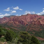
Access to portions of the Kolob Canyons District of Zion National Park will be restricted due to a construction project beginning May 1, 2018. The project involves reconstructing sections of the road, repaving the entire road, and adding accessible parking, sidewalk, and toilet facilities.
All of Kolob Canyons Road, the Visitor Center, and parking lot off of Interstate 15, will be closed to all traffic during the seven month project. The Taylor Creek Trail, the Timber Creek Overlook Trail, Lee Pass Trailhead and other areas served via the Kolob Canyons Road will not be available to the public.
Overnight permitted hikes will be drop off / pick up only, from April 15 through April 30, 2018. No vehicles or hiking will be permitted inside the closure beginning May 1, 2018.
Construction engineers and Park officials have determined that closing these areas during the project will be safest for visitors and workers, as well as expediting the work, so the area may open at the soonest possible date.
Visitors will be able to access the La Verkin Creek Trail and hike to the Kolob Arch via the Hop Valley Trail. Visitors may access the Hop Valley Trailhead from the Kolob Terrace Road. Overnight trips require a permit. There are many surrounding State Parks, Forest Service and public land scenic areas to consider as alternatives to Kolob Canyons during this closure.
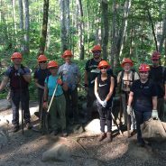
Great Smoky Mountains National Park officials announced several volunteer workdays beginning April 5 through April 28, 2018 along heavily-used trails and nature loops as the park prepares for the busy summer season. These opportunities are ideal for people interested in learning more about the park and the trails program through hands-on service alongside experienced park staff.
Volunteers will help clear limbs and debris that have fallen over the winter months along with helping repair eroded trail sections. Workdays will be held from 9:00 a.m. to 3:00 p.m. in North Carolina on April 5, April 7, and April 19 and in Tennessee on April 12, April 21, and April 28. Prior registration is required.
Please contact Trails and Facilities Volunteer Coordinator Adam Monroe at 828-497-1949 or [email protected] for workday details and to register. Interested volunteers can also contact Monroe to learn about additional volunteer opportunities throughout the year including the ‘Adopt-a-Trail’ program and the Trails Forever ‘Working Wednesdays’ opportunities on Rainbow Falls Trail beginning April 25 through August 29. These opportunities are perfect for those with busy schedules who would like to volunteer once a month.
For the April trail workdays, volunteers must be able to safely hike while carrying tools up to 4 miles per day and be prepared to perform strenuous, manual labor. After receiving proper training, participants will be expected to safely use hand tools such as shovels, rakes, loppers, and hand picks. Minimum age of participants is 16. Those under 18 must be accompanied by a responsible parent or guardian.
Volunteers will need to wear boots or sturdy closed toed shoes, long pants and appropriate layers for cold and inclement weather. Volunteers should bring a day pack with food, water, rain gear and any other personal gear for the day. The park will provide instruction, necessary safety gear, and tools for the day.
For more information about the volunteering in the park, please visit the park website at https://www.nps.gov/grsm/getinvolved/volunteer.htm.
With spring officially here, shake off those winter blahs with one of Tennessee State Parks’ “Happy Spring” hikes, where all 56 of our state parks will offer at least one ranger-led hike on March 24, 2018.
Whether you are up for a strenuous all-day outing or a leisurely walk outdoors, or something in between, Tennessee parks have some great options. And many of them are family friendly.
Park officials said that all of the All Park spring hikes are free and will be guided by park staff members who can “speak to the natural, cultural and historical treasures that Tennessee State Parks has to offer.”
For example, join state naturalist Randy Hedgepath for his yearly “Collins Gulf Wildflower Pilgrimage,” which takes you into one of his favorite wildflower areas. Hedgepath says, “Flowers are very abundant, but there are also waterfalls and spectacular scenery throughout. The hike is a 5-mile round trip and is rated strenuous because of the rugged terrain and the 600-foot descent and climb out. This is a challenging hike but has great rewards.”
Learn more, with meetup times and other suggestions here…
The Ozark Trail Association is proud to announce the 2nd annual Taum-A-Hawk Hiking Race, a one-day event open to the public, to take place on Saturday, June 9th, 2018 along thirteen miles of the Ozark Trail Taum Sauk Section from Taum Sauk Mountain State Park to Johnson’s Shut-Ins State Park located in Iron County, Missouri.
Traversing through the most scenic and rugged areas of the entire state, mixed-gender teams of two, up to seventy-five teams in total, will hike a time-trial formatted race beginning in the morning at the summit of Taum Sauk Mountain, the highest point in Missouri, then heading down, alongside Mina Sauk Falls and west into the Taum Sauk Creek Valley, past the Devil’s Tollgate rock formation, and then back up across Proffit and Wildcat Mountains before finishing near beautiful Johnson’s Shut-ins State Park. The Taum-A-Hawk 2018 is patterned after team dynamic-based adventure races which require mixed gender teams for fairness.
The Ozark Trail Association Taum-A-Hawk 2018 is a one-day hiking race open to the public, not a trail running race. Participants must be over the age of sixteen in co-ed teams consisting of two people where classic hiking items will be required of each participant like a backpack, trail map, appropriate footwear, a minimum amount of carried water (1L), and other safety items like battery-powered flashlight/headlamp.
For more information on race requirements, rules, details on location, and where to officially sign your team up, please visit www.ozarktrail.com or contact Abi Jackson at [email protected].
At the end of February, three Maine men set out on snowshoes to hike the 100-Mile Wilderness, the most remote section of the Appalachian Trail stretching about 100 miles from Monson to Baxter State Park. They completed the arduous journey, over mountains and across half-frozen streams, in nine days, a feat very few hikers accomplish in the winter.
For February, the weather was mild, but that didn’t make traveling any easier. In fact, the three wished the weather had been just a bit colder. With the temperature hovering around freezing on most days, it was nearly impossible for them to dry out their clothing and boots. Snow would melt from the tree branches above, raining down on them non-stop.
They packed enough food for 10 to 12 days, but the trail was slow going, especially at high elevations, where the snow was several feet deep. To cover enough distance each day, they rose early, cooked up some powdered eggs and bacon, then hit the trail, snowshoeing often 10 hours before making camp.
One day in particular stood out to all three men as especially challenging — the day they hiked White Cap Mountain. Rising 3,707 feet above sea level, White Cap is famous for the spectacular view from its summit, which includes Mount Katahdin, Maine’s tallest mountain and the location of the AT’s northern terminus. Hiking toward White Cap, the three followed the ridgeline of Gulf Hagas, West Peak and Hay Mountain, where the snow was at least 4 feet deep, and the trail, cut through a thick forest of evergreens, had almost vanished.
“The green tunnel that’s normally 6 feet high was 2 feet high because we were on top of so much snow,” Koorits explained. “So we were basically crawling through the trees for 5 miles.”
If the array of trails in Massachusetts’ North Quabbin region, including those along the Millers and Tully rivers, could be connected to the network of trails up near Mount Monadnock in New Hampshire, New England would have a world-class hiking jewel of its own.
The North Quabbin Trail Association, in partnering with municipalities, naturalists and nonprofit organizations, is expected to announce the completion of the 240-mile “Q and M” Trail in the next year.
The Q and M Trail — the name stands for Quabbin and Monadnock — is set to connect Franklin and Worcester county trails with those of southern and central New Hampshire in one giant loop, and feature 30 to 35 overnight stops along the way.
Nearly all of the trailblazing has been completed. North Quabbin trails the association already has stewardship over — like the Tully Trail in Royalston or the newly completed Poplar Mountain Cliff Ridge in Erving — will finally become one, and also stretch up to Mount Monadnock, the second most hiked mountain in the world.
There will be eight interconnected regions: Tully River basin, Millers River basin, Swift River basin, Quabbin basin, Farley Ledge Loop, Mount Grace, Warwick Forest and the Metacomet-Monadnock Trail.
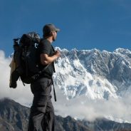
The good news is you don’t need to be Sir Edmund Hillary to experience the Himalaya Mountains. In fact whatever your age, abilities or experience almost everyone can hike the Himalaya.
As the highest mountain range on the planet, the Himalaya have long been a draw for explorers heading to Nepal, India, Bhutan, Tibet, and Pakistan.
Furthermore, the countries the Himalayas span are exotic, with very different beliefs, languages, food, flora and fauna to Western countries.
While accessible to pretty much all, trekking in the mountains is not like a walk in the park. There are many things you can do to prepare yourself before you go; to improve your experience whether you go for full on trekking, easier hiking or just a walk in one of the many national parks.
Rocking up in the Himalayas without any prior preparation would be a recipe for disaster. Fitness goes hand in hand with enhancing your overall trekking experience. The fitter you are the more pleasurable your experience will be. Trekking in the Himalayas involves many days walking at a time, up to 8 hours, with distances upwards of 10km/day. The key is to build your endurance level over time.
Get the full list of tips for trekking in the Himalayas…
In an unexpected turn earlier this week, the Pikes Peak Cog Railway, which had stopped operating for the winter for maintenance work, announced that it would not resume operations in the spring, and may not operate for several years — or ever again.
Other than a yet-to-be-seen impact to local tourism, both in visitor numbers and revenue, the closure of the railroad may also have an affect on outdoor recreation on the peak.
The Cog is more than just a tourist attraction; it’s a transportation system. Many Barr Trail hikers use the Cog as the return leg of their hike to the summit, saving their knees from the rigors of a long downhill trek. Those hikers also invariably stop at Barr Camp, the approximate halfway point on the trail.
Whether stopping in to take a break, chat with the caretakers or spend the night on the way up or back down, Barr Camp is an essential waypoint — often life-saving — for people venturing on the trail, and the Cog has been a vital part of the camp’s operations.
Other groups utilize the Cog as well. Medicine Wheel Trail Advocates relied on the Cog to deliver people and equipment while they were building the Lake Moraine Trail (formerly the “missing link” trail) last year.
April 21-22, 2018 weekend will see the kickoff of a season of celebrations of the 50th anniversary of the Ganaraska Hiking Trail Association, Inc. (GHTA), an association of nine member clubs stewarding a 500 km trail stretching from Port Hope (Lake Ontario) at the southern terminus, to Devil’s Glen near Glen Huron, (just south of Blue Mountains) at the western terminus.
The trail winds through rolling farmlands and woods, follows quiet country roads and small towns and villages, and even traverses a city (Orillia, Ontario). The wilderness section of the Ganaraska Hiking Trail, is unique and passes through the Queen Elizabeth II Wildlands Provincial Park. Including branch trails, the total length of the trail is in excess of 500 kilometres, used for hiking, snowshoeing and cross-country skiing, thanks to the generosity of landowners who have given permission to cross their land.
The association will be 50 years old as of April 21, 2018, and the first of the celebratory events will be a public hike offered by the member clubs on Saturday, April 21 and Sunday, April 22.
These hikes will be easy to moderate, and everyone, including families, novice hikers, nature lovers, and those curious about hiking, are invited to come along and join in the celebrations.
The 40th birthday of the Continental Divide Trail will be celebrated during Silver City Trail Days. The event takes place April 27-29, 2018 and is the fourth annual Trail Days festival. It not only celebrates the Continental Divide, but also the outdoor culture of New Mexico and Silver City being a gateway community.
“Trail Days brings people from all over the world to experience the beauty of southern New Mexico,” Silver City Mayor Ken Ladner said. “The Continental Divide Trail is a wonderful asset to our state and our community, and this event is the perfect way to celebrate and learn more about the Trail.”
The free festival welcomes seasoned hikers as well as those who have never set food on the Continental Divide Trail. It’s being organized by the Continental Divide Trail Coalition. This year marks the 40th year since Congress designated the CDT in 1978. The party will take place Friday, April 27 at the Seedboat Gallery and will feature local music, door prizes, beer, wine and a giant birthday cake.
Those interested in learning more about hiking and other recreation on the Continental Divide Trail can attend presentations Saturday and Sunday on the campus of Western New Mexico University. Topics will range from desert hiking safety to diversity in the outdoors, to planning multi-day hiking trips along the Continental Divide Trail.
Hiking outdoors offers lots of perks like fresh air, nice views, together with the sounds and smells of nature. So next time when somebody suggest you join a hike, thank them for taking care of your health. There is research that has proven that spending quality time outdoors will boost creative problem-solving talents and attention spans by around 50%.
Hiking offers various benefits for both mental and physical health and your well-being. Hiking for an hour will help to burn 500 calories from your body based on the terrain steepness and your backpack weight. Above all, getting in touch with nature, leaving behind the chaos of technology and routine lives will let you connect with the nature. It provides you with a good sense of well-being and peace.
A good hike will help your heart to stay healthy since it is great cardiovascular exercise. The finest part of hiking is that it covers a whole continuum – right from a gentle walk on some flat terrain to the steepest mountain climbing routes. It makes your heart pump more blood, thus satisfying the demand for the oxygen supply while hiking.
Gentle or brisk walking movements are ideal for increasing your cardiovascular fitness, and this is best when the trails are hilly. It helps to exert a stress on your heart to work harder. On the other hand, hiking on an uneven terrain will give you a natural way to engage the core muscles. This will also improve your balance skills. Hiking is a strong cardio workout that helps to reduce the risk of heart disease along with boosting your bone density. Walking is considered a powerful weight-bearing exercise.
My new friend Arun from Riderstrail sent along this neat new infographic to help explain many more ways that hiking is good for your health.

Few pieces of gear are as beloved as a favorite pair of boots. Not only do they accompany you on your most scenic adventures; most of the time they bring you there.
So it’s understandable you wouldn’t want to part with them – even if they’re ratty, ragged, and smell like a wet barn. Well, there’s good news: Your boots can live a longer, happier life. And you can prepare for the end knowing how long they should last.
According to the experts, hiking boots of solid construction will carry you for at least 600–700 miles, generally maxing out at 1,000.
Once you picked out boots – or trail shoes – with longevity in their genes, it’s up to you to keep them healthy. But that doesn’t mean avoiding puddles and laying a drop cloth at the campsite. You just need to care for your footwear after the adventure.
“Gently brushing off dirt and mud after your hikes, or gently cleaning the upper with a piece of cloth and some warm water, will all help extend the longevity of the materials.”
At the very least, you should kick and scrub off any caked-on mud and filth. Moisture, salt, and muck will dry out materials and deplete the footwear’s life if left untended. For synthetic materials, use a stiff brush or warm, damp cloth to clean debris.
For leather boots, use leather cleaners and conditioners.
The “Great Wall” is a bit of a misnomer, as there was never one single structure that spanned modern-day China. Rather, a number of large defensive walls were built by various rulers from as early as the Fifth Century B.C. through the mid-17th century, often hundreds of miles apart and with little relationship to one another.
Yet one of those sections, the “Ming Wall,” is recognized all over the world. Built during the Ming dynasty (1368 — 1644) it stretches from a fort at Jiayuguan near the Gobi Desert in the west, all the way past Beijing to the sea at Shanhaiguan in the east. By some estimates, it is 5,500 miles long.
Unlike other sections that were made of rammed earth and straw, most of the Ming Wall around Beijing is built on a foundation of cut stone and bricks held together with an early — but very strong — mortar made of lime and sticky rice glue. With crenelated ramparts and tall towers, it is the Great Wall of the imagination.
All over China, sections of the wall are being rebuilt by unregulated private contractors who are keen to capitalize on tourist dollars but show little interest in historically accurate restorations. Foot by foot, the largest man-made structure in the world is being paved over, funded by visitors who funnel through them every year, largely unaware of what they are missing.
But, a longtime Beijing resident, also a keen amateur explorer, is writing a field guide about hiking on the wild, unrestored sections of the wall — his particular area of interest.
The U.S. Forest Service says it is closing parts of the George Washington and Jefferson National Forests in Virginia and West Virginia as construction begins on the Mountain Valley Pipeline.
The department issued an emergency closure order affecting land in Giles County and Montgomery County in Virginia, and Monroe County in West Virginia.
According to a release from the Forest Service, the closure order “was enacted to protect public safety due to hazards associated with constructing the Mountain Valley Pipeline.”
The order is set to last for 12 months and prohibits going into or to be upon Forest Service lands within 200 feet of the centerline of the pipeline right-of-way, excluding the footpath of the Appalachian National Scenic Trail and Brush Mountain East Road.
Also off-limits are access roads Mountain Valley will use during construction. It will be prohibited to operate, park, leave, or simply possess a vehicle on Mystery Ridge Road for its entire length, and Pocahontas Road from the first Forest Service gate to the intersection with Mystery Ridge Road.
The forest service says the Appalachian Trail, which will be crossed by the approximately 300-mile natural gas pipeline, will stay open during construction.
Any federal, state, or local officer, as well as any member of an organized rescue or firefighting force engaged in the performance of an official duty, will be exempt from the order, as well as anyone working under a permit issued by federal, state, or local regulatory entities that authorize activity within the area.
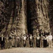
Quick – what’s the largest living thing in the world?
The honor goes to the giant sequoia – the “god of the woods” to conservationist John Muir – and the best place to see it is in Sequoia National Park in California’s rugged Sierra Nevada mountains.
Located some 225 miles north of Los Angeles, the park stretches across 631 square miles of jagged peaks, meadows bursting with colorful wildflowers, canyons that plunge thousands of feet, and marble caverns. But the park’s most famous feature is the giant sequoia, a staggeringly massive species that grows naturally only on the moist, western slope of the Sierra Nevada above 5,000 feet.
By total volume, Sequoiadendron giganteum has no equal. It can be wider than a city street, and contain enough lumber to build 35 homes. A single branch can grow 50 feet long. Some giant sequoia existing today were tiny saplings as far back as 1,000 B.C.
To protect the unrivaled monarch of the forest, President Benjamin Harrison in 1890 designated Sequoia the nation’s second national park, after Yellowstone. That put the kibosh on logging and today Sequoia National Park is thick with thousands of magnificent specimens.
Active Southern West Virginia, which partners with the New River Gorge National River to provide enhanced outdoor exercise opportunities in the region it serves, is expanding into the state parks system to host monthly guided hikes.
The four-year-old nonprofit dedicated to improving regional public health offers a variety of group activities in the New River Gorge, ranging from tai chi and yoga to the basics of rock climbing and stand-up paddleboarding. The activities are led by trained “community captains” and are offered free to the public.
Starting in April, Active Southern West Virginia will begin offering First Sunday hikes in four New River Gorge area state parks — Bluestone, Pipestem, Babcock and Carnifex Ferry Battlefield State Park. The hikes, free and open to people of all ages and abilities, will take place on the first Sunday of each month, starting on April 1 at Pipestem.
“The ability to take the success we’ve seen with our partnership with the National Park Service and expand that into our state parks is extremely exciting,” said Levi Moore, one of two community captains who will be leading the First Sunday Hikes. West Virginia State Parks, he said “offer even more opportunities for local community members to get outside and explore West Virginia.”
The hikes are being offered on Sundays in order to offer an outdoor activity to “people who are looking for something to do on Sunday afternoons between church services or after family lunches, or even because that’s the only day they have to get outside,” Moore said.
“I’d love to see us doing multiple events in the state parks in the New River Gorge region in addition to the First Sunday hikes,” he added. “My hope is that this initiative is just the beginning of an outstanding long-term partnership.”
Free Active Southern West Virginia t-shirts, social media recognition, and an invitation to the Active Southern West Virginia Appreciation Awards Dinner in December can be earned by taking part in at least one First Sunday hike in each of the four participating state parks.
For more information about First Sunday hikes and other Active Southern West Virginia activities, call 304-254-8488 or visit www.activeswv.org/events.
“Last year was the most challenging year we’ve had in terms of dealing with closures on the PCT,” said Beth Boyst, who for the last 11 years has been the trail’s chief administrator with the U.S. Forest Service (the PCT passes through all different designations of federal and state land, but USFS holds the lead oversight role). Boyst’s tenure has seen the PCT through some tenuous conditions. She watched California’s five-year drought take its toll on the trail, only to be mitigated by last year’s near-record snowfall that made hiking the Sierra Nevada mountains—even in midsummer—a dubious proposition.
The PCT, “America’s Wilderness Trail,” runs from the Mexican border to Canada, traversing some of the West’s most iconic places: the Mojave Desert, the Sierra, the Cascades. That it even exists is a symbolic statement about the country’s priorities—a single pathway from the southern border to the northern border of the United States, the vast majority of it on public land.
As it traces its way through six national parks, 25 national forest units, and 48 federal wilderness areas, it weaves a narrative of changing ecosystems and the monumental effort required to set aside and protect each one. It’s not just the snow-capped peaks that make the PCT iconic. It’s the long stretches in the arid Southern California desert, the thick, sunlight-blocking forests in the Pacific Northwest, the fact that they’re all part of the same trail and open to the public.
Every year, a few hundred thru-hikers walk the trail’s entire 2,650-mile length, but the number of people who simply set foot on some part of it each year is closer to a million. For thru-hikers, desert conditions in the south and heavy snowfall at high elevations mean their five-month hike must take place in a short window, generally between April and September.
Even more so than its East Coast sibling, the Appalachian Trail, the PCT is uniquely susceptible to the effects of climate change. “The West has been the center of the warming, and the warming in the West has been greater than it has been in the East,” said Hugh Safford, a regional ecologist with the Forest Service’s Pacific Southwest office. “Water stress is a much bigger issue in the West.”
 I am Jeff Clark, founder of Internet Brothers, producer of this blog, and passionate about hiking. I live in Western NC near the Blue Ridge and Great Smoky Mountains. Pisgah and Nantahala National Forests are just out my door, so the content will focus on these areas, but let me know what you would like to see on the site.


Copyright © 2011-2023 Internet Brothers. All Rights Reserved. ISSN 2324-6057
Designed by Elegant Themes | Powered by Wordpress | Logo by Design Aspirations