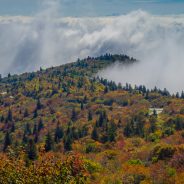
The Bay Area’s abundance of outdoors activities is no secret, and now that spring and springtime rains are here, there’s no better time to get outside, especially if you don’t mind a little mud on your shoes.
Uvas Canyon County Park, a formerly obscure South Bay hiking retreat, is now so popular for its Instagram-friendly waterfalls that it now requires reservations on weekends. The winter rains have revitalized the Bay Area’s rivers, and turned native waterfalls into spectacular cascades.
Waterfall season proved dry in most recent years, due to the drought, but this winter helped replenish the landscape.
Here are a few picturesque destinations for hikers outside of Uvas Canyon (busy as it’s bound to be again this weekend), from the humble to the mighty, from the famous to the obscure, from Golden Gate Park to the beaches of Point Reyes.
While you’re at it, there are also links to other great Bay Area hiking adventures that don’t involve water.
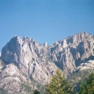
With one short jog from Interstate 5 in Northern California, you can discover the state park that is hidden in plain sight.
The turnoff is at Castella, bound for Castle Crags State Park. Drivers on I-5 get eye-popping views of the granite spires, pyramids and a missile-shaped dome that poke 6,000-foot holes in the sky.
Each hour, about 2,000 vehicles pass by Castle Crags, according to Caltrans. Of those, an average of about 18 — or roughly .09 percent — take the Castella turnoff. Most make the short drive into the park to Vista Point, take pictures of Castle Crags, use the restroom, and then head back to I-5. Only a handful stay to hike, bike, fish, explore or camp.
Even on three-day weekends, Castle Crags is one of the few state parks that has available campsites. In addition, the park has some little-known walk-in sites nestled near the upper Sacramento River, a mile from the main campgrounds.
Seeing the towering crags for the first time can be shocking — but it’s only the start.
Check out these fantastic hiking trails…
Blame it on the region’s tricky geopolitics or the former Soviet Union, but the mountains of the Caucasus – a high and sheer rocky spine soaring between southwestern Russia and Iran – still for the most part lie untouched and undiscovered.
That’s all about to change thanks to 34-year-old Tom Allen, who has seen the potential of these peaks and is resolute in helping them earn the attention they deserve as a destination.
How? By creating the Transcaucasian Trail – an ambitious, 3,000-kilometer hiking route that will crisscross Armenia and Georgia all the way from the Iranian border to the Georgian-Turkish frontier, and will make odysseys on foot through these rugged and hardly accessible mountains possible.
By the end of the summer of 2017, his team of local experts and international volunteers completed the first 100 kilometers of trail, through Armenia’s Dilijan National Park.
At the same time, a sister operation led by the Transcaucasian Trail’s co-founder, American and former Peace Corps volunteer Paul Stephens, has completed a section of the trail in the Svaneti region of northwestern Georgia.
The final, enormous trail may take up to a decade to complete, says Allen – and several months to hike in its entirety. Hikers will be able to join the first fund-raising expeditions in the summer of 2018.
Unlike many other outdoor activities that require extensive training, a hefty investment in equipment, and oftentimes a superior level of fitness, hiking is a fairly accessible and affordable way to get out and get active for mostly everyone.
With that said, seeing a hiker get injured is a good reminder of how quickly a leisurely hike can turn into a dangerous and potentially life threatening situation if you aren’t prepared. Accidents and injuries can happen with beginners and avid hikers alike.
Witnessing a new-to-hiking teenager slide down a steep hill while on a hiking adventure last week was a fresh reminder of what can happen to anyone.
While the situation was not life threatening, the young hiker most certainly suffered from a concussion, and needed multiple stitches to close up the large cut along the side of his face. Sometimes accidents just happen, but there really are simple steps you can take before hitting the trails to avoid this from happening to you.
So what can you do to avoid accidents and injuries while hiking?
The Len Foote Hike Inn is nestled in an exceptionally beautiful stretch of the southern Appalachians. It’s an environmentally sustainable backcountry lodge that’s accessible only by hike, clad in beautiful rustic/modern architecture and a comfortable and welcoming spirit, and dishing fresh and delicious cuisine on a mountaintop with incredible vistas.
It’s only accessible via the Hike Inn Trail, a moderately challenging, five mile hike from the crest of Amicalola Falls, Georgia’s tallest waterfall. The hike explores a diverse landscape dotted with beautiful ridges, overlooks, and rhododendron-filled creek valleys. While the hike itself is worthy of the journey, it’s the warm hospitality, comfy furnishings, and great conversation at the inn that make this an exceptionally worthwhile adventure.
Springer Mountain, the southernmost blaze on the iconic, 2000+ mile Appalachian Trail, is a day hike away. The inn is an equally fantastic place to cozy up with a good book, play a board game with a friend, stargaze under a blanket of abundant stars, and catch morning’s first light from a lofty overlook.
The inn offers the chance to stay in a particularly scenic and remote wilderness area, with many of the pleasures of backpacking without the need to pack a heavy load. The inn features twenty guest rooms, and linens are provided, so all that’s needed for a stay is a toothbrush, toiletries, and a change of clothes, in addition to the usual hiking gear for a day hike. Add in some great company, seriously delicious meals, and those oh-so-memorable sunrises, and this is an experience that’s fully worth repeating.
Mud season can be a challenge for hikers and trail maintainers alike. So if you want to hike in the spring, knowing how to safely enjoy soggy trails without destroying them is an essential outdoor skill.
“More and more people are hiking year-round, and while it is wonderful to have people enjoying the trails, [hikers] are also having an impact,” says Alex DeLucia, the manager of AMC’s trails volunteers and Leave No Trace programs.
According to DeLucia, the saturated surfaces following spring snowmelt are a trail maintainer’s nightmare. Each hiker’s step churns up mud and sets the stage for serious erosion. “Some maintainers would like to see most trails closed in mud season, but we prefer to ask people to hike responsibly in all seasons,” he says.
Early spring hiking etiquette requires always walking in the center of the treadway. Sticking to rocks wherever possible will preserve both the trail and your footwear, and stepping into water and mud when necessary will minimize trail damage. Although you may be tempted to walk along the sides of the trail to keep your feet dry, doing so loosens soil and makes the trail more susceptible to erosion.
The Cradle of Forestry in America Heritage Site will begin the 2018 season on April 7 with a living history event, “Old Time Plowing and Folkways.”
David and Diane Burnette from Haywood County will demonstrate how their Percheron draft horses work the land the old way. Weather permitting, they will plow the Cradle’s vegetable garden along the Biltmore Campus Trail and teach a skill that was once familiar to many.
The Cradle of Forestry’s living history volunteers will demonstrate their crafts among the historic buildings, including wood working, chair caning, carving, tatting, mountain mandolin music, and crafting corn husk dolls.
The Cradle of Forestry will be open daily, 9 a.m. – 5 p.m., from April 7 – November 11. At various times during the season, living history volunteers will demonstrate wood carving, fiber arts, blacksmithing, traditional music and more. The Giving Tree Gift Shop at the Cradle offers many of their creations as well as forest related books, maps, gifts and snacks. The Café at the Cradle will serve lunch from 11 a.m. to 3:00 p.m. daily, except Mondays.
A full schedule of events is planned in 2018 including Migratory Bird Day May 5, the Songcatchers Music Series Sunday afternoons in July, and Forest Festival Day October 6. Visit www.cradleofforestry.com for a full event schedule, details and updates on interpretive programs and exhibits.
The Cradle of Forestry in America is proud to be part of the Blue Ridge National Heritage Area. Throughout the season it offers many opportunities to explore the five themes of Blue Ridge Heritage- craft, music, natural, agricultural, and Cherokee heritage.
Admission to the Cradle of Forestry is $6.00 for adults and $3 for youth ages 4-12. America the Beautiful passes, Golden Age Passports and Every Kid in a Park passes are honored. Friends of the Cradle Annual passes are sold on-site. These passes are good for free daily admission, half-price to special events, and 15% discount in the Gift Shop.
Admission includes the film, First in Forestry- Carl Alwin Schenck and The Biltmore Forest School, hands-on exhibits and scavenger hunts. It also includes historic cabins, antique equipment and forest scenery on three paved trails, the Adventure Zone designed to reach children with autism and engage young families, and guided trail tours and living history demonstrations when available.
The Cradle of Forestry is located on Hwy. 276 in the Pisgah National Forest near Brevard, six miles north of Looking Glass Falls and four miles south of the Blue Ridge Parkway. For more information call 828-877-3130 or go to www.cradleofforestry.com.
Michigan’s Iron Belle Trail is the longest state-designated trail in the nation, encompassing more than 2,000 miles of hiking and biking routes, allowing users to explore pristine forests and cool rivers while connecting big cities to smaller and diverse towns.
The trail extends from Belle Isle in Detroit to Ironwood in Michigan’s western Upper Peninsula. It is slated to span 2,019 miles. The trail is approximately 68 percent completed.
In an effort to leverage funding to advance progress toward completion of this statewide trail, the Michigan Department of Natural Resources has awarded $515,000 in local funding to 28 communities to help develop and enhance it.
Funded projects were eligible to receive up to $30,000 for trail enhancement projects including feasibility studies, preliminary construction, engineering of new trail segments, signage for trail segments and trailheads, environmental impact studies and other uses. For this round of funding, the DNR received 56 applications.
This is the fourth year the DNR has issued grants specifically for Iron Belle Trail development. The department awarded $250,000 in 2015, $350,000 in 2016 and $350,000 in 2017 for a variety of projects, many of which have been completed or are nearing completion.
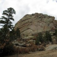
One of the wonders of northern New Mexico is the variety of landscapes in every direction.
One day you can ski or snowshoe in the Sangre de Cristo Mountains and the next be walking on the desert mesa above the Rio Grande. One of the less visited areas is the Tres Piedras Ranger District of the Carson National Forest, northwest of Taos about 30 miles.
The area has stands of aspen, ponderosa pine, juniper and scrub oak and is at the southern end of the San Juan range of the Rocky Mountains. Although it doesn’t have as many trails as some of the other Carson National Forest ranger districts, it is a popular area for cross-country skiing, climbing and some hiking, in areas such as Mosaic Rock.
Past the small town of Tres Piedras, the ranger district office on U.S. 64 is a good jumping off point for exploring. Knowledgeable staff members and maps are available. The area is rich in history.
Archeological investigations show that hunter and gatherers lived here thousands of years ago as did the Jicarilla Apaches in the 1800s. The Forest Service plans to build on the past while adding to and improving trails in the future.
Access to the Mosaic Rock area is a bit past the ranger district office. Well-known in the climbing community as a place to boulder and scale the massive rock walls, it is also a good destination for a short hike and a scramble to the accessible shelves of the rock formation.
Tres Piedras is named for this area, but you will find at least six rock formations rather than three. At the parking area, look for the public entrance marked as TP Rocks entrance.
Stretching between the Canadian and Mexican borders, the Continental Divide Trail connects five states, 25 national forests, 21 wilderness areas, three national parks, eight Bureau of Land Management resource areas, and a national monument. Its many miles are maintained through the collaboration of every land management agency and by an army of volunteers — including long distance hiker Dan Fenn, who would start coming back to Montana to volunteer on trail projects in the years following his 2010 hike.
The majority of Continental Divide Trail hikers travel northbound to the Canadian border, kicking up dust in the warming springtime Southwest, smelling Colorado’s alpine wildflowers at high bloom, and then welcoming autumn in Idaho and Northwest Montana. After a few thousand hard miles, Glacier National Park is the victory lap.
“Once you get to the Bob [Marshall Wilderness], you’re almost there,” Fenn said. “You go through Glacier, which is just spectacular. You look back at where you started, at the Mexican border, flat as a pancake and dry … Boy, I tell you, there’s not much to compare [Glacier] to. You go out on a big note.”
Fenn says the Continental Divide Trail “has a reputation of being the wildest, most out-there, and the ruggedest” of what’s known as the “Triple Crown.” Fewer than 300 hikers have officially completed this trifecta, which represents the best of American long-distance hiking. It includes the East Coast Appalachian Trail, the West Coast Pacific Crest Trail, and the Rocky Mountain Continental Divide Trail. Totaling approximately 7,900 miles altogether, these trails also share protections by the National Trails System Act, which was written into law in 50 years ago in 1968.
The Pisgah National Forest will be holding an open house on Tuesday, April 10, 2018 from 5-7 p.m. at the Pisgah Ranger Station to discuss a proposed project to increase the sustainability of recreation.
“The project is not intended to address all possible improvements on the Pisgah Ranger District, but includes timely projects that consider the social, ecological, and economic elements of sustainable recreation,” said Dave Casey, District Ranger. “This includes construction of connector trails, re-routing trails, trail head modifications, change of authorized trail use, select roadside campsite closures, watershed improvements, road decommissioning, and heavy trail maintenance.”
The proposed changes to the trail system fit within the larger trail system goals below:
Public input will help to evaluate the proposed actions and identify potential issues. Comments for the project can be submitted by attending the open house on April 10 or by submitting them online here.
Comments can also be submitted by visiting the Pisgah Ranger Station from 9:00 am-4:30 pm or mailed to Pisgah Ranger District, USDA Forest Service, Attn: Jeff Owenby, 1600 Pisgah Highway, Pisgah Forest, NC. Comments will become part of the project record and may be released under the Freedom of Information Act.
To be most useful, please submit comments within the official 30-day scoping period which ends April 27.
Cold but dreamy snowfalls punctuated by balmy, hurry-up-and-hike days made for an unpredictable winter on the Blue Ridge Parkway, but according to the calendar, it’s officially spring. Soon campgrounds, visitor centers, picnic areas, and historical sites will be ready for the influx of travelers. In 2017, more than 16 million came to experience the mountains and the communities along the way.
You can lay out the welcome mat for those travelers during the Project Parkway Campground Cleanup event from 9 a.m. to noon, Saturday, April 21. The National Park Service is inviting Parkway fans to help with a variety of preparations, from leaf blowing and tree limb clearing to painting and trail work at all eight campgrounds.
The Linn Cove Viaduct at Grandfather Mountain is closed until May 24 for repaving and repairs. A traffic detour will be put in place from milepost 298.6 (Holloway Mountain Road) to Milepost 305.1 (U.S. 221). Gates will be located at milepost 303.6, Wilson Creek Overlook on the north and milepost 305.1, U.S. 221 on the south end of the work zone. Within the closed area, including the trail areas beneath the viaduct, the Parkway will be closed to motorists, cyclists, and pedestrians.
Each spring, Flat Top Manor is one of the first visitor stops to open along the Blue Ridge Parkway thanks to the Southern Highland Craft Guild. Starting March 30, be sure to visit the group’s Parkway Craft Center at the manor, which features handmade crafts from hundreds of regional artists as well as live demonstrations of quilting, pottery, wood carving, glass blowing, and more on the front porch. You’ll see a new layout inside Flat Top Manor this year with the main foyer cleared for an experience that more closely resembles the days the Cones were in residence.
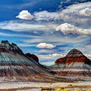
One of the largest concentrations of petrified wood in the world is found at Petrified Forest National Park in eastern Arizona, about 110 miles east of Flagstaff and 210 miles west of Albuquerque, New Mexico.
Scientific studies show that the petrified trees found within the park date back 211 to 218 million years. Add to that dramatic, colorful geological formations and ancient art and you’ll quickly see why Petrified Forest National Park is a must-visit; last year, just over 643,000 people trekked through the park.
In December 1906, President Theodore Roosevelt created Petrified Forest National Monument, and 56 years later, in 1962, it was designated a national park.
A terrific way to experience the park is by lacing up your hiking shoes and hitting the trails. A one-way spur road from the main park road leads to Blue Mesa and a one-mile loop trail in a badlands setting. Additional hiking options include the one-mile round trip Painted Desert Rim Trail; 0.3-mile Puerco Pueblo loop; 0.75-mile Crystal Forest loop; 0.4-mile Giant Logs loop; 1.6-mile Long Logs loop; and the 2-mile roundtrip Agate House trail.
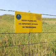
The U.S. Fish and Wildlife Service plans to open the Rocky Flats Wildlife Refuge in Colorado to the public this summer despite attempts to block developing the refuge, which circles a shuttered nuclear weapons production facility.
Private tours have already started, U.S. Fish and Wildlife Service refuge manager David Lucas said. No hard date exists yet for the full opening but it is expected to be this summer.
“The neat thing about Rocky Flats is it has been undisturbed for the past 70 years as opposed to lands on the other side that have been extensively grazed,” Lucas said.
In anticipation of the opening, the Fish and Wildlife Service is continuing to coordinate with Jefferson County to collect additional air, water and soil samples to ensure safety.
Lucas said local governments are also working to connect the refuge trails to the surrounding area, including Boulder County Open Space.
The Colorado Department of Public Health and Environment, the Environmental Protection Agency and the Department of Energy contend that no lingering danger exists to humans from exposure to any residual contaminants, but critics have a long-running skepticism of those findings.
Rocky Flats is considered a globally rare habitat and is the largest undisturbed track of high prairie grass on the planet, Lucas said.
In June 2010, Bill Ewasko traveled alone from his home in suburban Atlanta to Joshua Tree National Park, where he planned to hike for several days. Ewasko, 66, was an avid jogger, a Vietnam vet and a longtime fan of the desert West. A family photo of Ewasko standing at the summit of Mount San Jacinto, another popular hiking destination in Southern California, shows a cheerful man with a salt-and-pepper mustache, looking fit, prepared and perfectly comfortable in the outdoors.
Ewasko left a rough itinerary behind with his girlfriend, Mary Winston, featuring multiple destinations, both inside and outside the park. His first hike, on Thursday, June 24, was meant to be a loop out and back from a remote historic site known as Carey’s Castle, an old miner’s hut built into the rocks. Carey’s Castle is so archaeologically fragile that, to discourage visitors, the National Park Service does not include it on official maps.
Winston, a retired mortgage broker, was worried about that particular hike. From what she had read, the site sounded too remote, too isolated. She so thoroughly pestered Ewasko about his safety that, when he arrived in California, he bought a can of pepper spray as a kind of reassuring joke. Don’t worry, Ewasko told her. He would be all right.
The plan was that after he finished the hike, probably no later than 5 p.m., he would call Winston to check in, then grab dinner in nearby Pioneertown. But 5 p.m. rolled around, and Ewasko hadn’t called. Winston tried his cellphone several times, and it went directly to voice mail.
She knew he might still be in a region of the park with limited cellular access, but the thought was hardly reassuring. As night fell on the West Coast with no word from Ewasko, Winston tried to call someone at the park, but by then Joshua Tree headquarters had closed for the day. Her only option was to wait.
Thanks to amazing weather and topography, southern Arizona can be a hiker’s dream. That dream can become a nightmare if you don’t take basic precautions or plan ahead, especially when the temperatures soar.
When the heat comes, hiking or other outdoor activities should be limited to early morning hours and be completed no later than 10 a.m.
Anyone planning on hiking should take the following precautions before heading out:
There’s that saying, “you can never be too overdressed for any occasion,” while that saying is commonly referred to dates, dinners, events and other entertainment type activities it’s also 100 percent applicable for hiking but for a different reason.
When it comes to hiking clothes, you should think about where you are going and how challenging the terrain. Is it Winter and will you be playing in the snow among the giants? Is it Spring or Fall and you’re touring Joshua Tree National Park? Is it August, 95 degrees and are you heading to Yosemite? While these locations present different and sometimes unpredictable weather patterns, a person can be prepared for all three by following one simple rule — layering.
Experts suggest borrowing equipment instead of buying new when first starting out. Hold off on buying new until you’ve made the decision you want to continue hiking and camping.
There are a few key materials to look out for when picking out hiking apparel. It’s also important to understand what different material has different benefits. Four key words to remember are wicking, waterproof, breathable and insulating. Four key materials to remember are wool, polyester/nylon, fleece and no cotton. Dressing for hikes in the winter is different than in the summer, but one material will keep you comfortable during both seasons. “Wool keeps you warm in the winter and dry in the summer.”
“The first two layers let your sweat out. The third layer should be windproof and waterproof.” A person’s base layer should be lightweight and the material should be able to pull the moisture away from the body. It should also be able to dry quickly. The base layer includes underwear, shirts and pants.
Did you know pilgrims don’t have to start their ‘Camino’ in Spain? That a ‘Celtic Camino’ allows you to kick off the route in Ireland?
For just over a year now, walkers who complete a ‘Celtic Camino’ – by walking at least 25km of a pilgrim trail in Ireland – can collect a special certificate issued by the Camino Society Ireland at St. James’ Church in Dublin.
The certificate – gained after walking routes like Tochar Phádraig, Co. Mayo or St. Kevin’s Way in Co. Wicklow – can then be taken to A Coruña and combined with a further 75km walk to receive the full compostela.
Typically, official Camino certificates are given only to walkers who complete at least 100km of the famous route. But the Cathedral of Santiago and A Coruña Tourism have agreed that 25km of Irish pilgrim trails can now be included.
“The Celtic Camino is a lovely idea, because you are linking the two countries together. It’s only a short hop down to Spain.”
Irish pilgrim paths are enjoying something of a second coming, as long-forgotten routes are cleared for use again.
 I am Jeff Clark, founder of Internet Brothers, producer of this blog, and passionate about hiking. I live in Western NC near the Blue Ridge and Great Smoky Mountains. Pisgah and Nantahala National Forests are just out my door, so the content will focus on these areas, but let me know what you would like to see on the site.


Copyright © 2011-2023 Internet Brothers. All Rights Reserved. ISSN 2324-6057
Designed by Elegant Themes | Powered by Wordpress | Logo by Design Aspirations