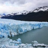
It’s said that if you eat the berries of the calafate bush you will return to Patagonia. Patagonia is a place that’s wild and windswept and so capacious it could constitute its very own country.
There are two Patagonias, the forest-cloaked Andes straddling Chile and Argentina, and the Argentinian steppe that flares eastwards for about 400 kilometres before petering out into the Atlantic Ocean. Capping this tableau like a rough-drawn border between two countries is the Southern Patagonian Icefield, a vast freshwater reserve that oozes into valleys and basins, carving out a geological history as it goes.
“If you come here [to the icefield] in November and December you can see orchids and hummingbirds – and glaciers!” says a guide.
It’s a marvel, for despite the frigid icecap and the chilled air arising from it, this is a temperate region filled with forests of beech and 10 species of orchid and that portentous, yellow-flowered calafate bush. Foliage curls between the boardwalk slats at Parque Nacional Los Glaciares, while Perito Moreno Glacier is caught mid-surge, a tsunami frozen in time. One of the world’s few advancing glaciers, the five-kilometre-wide behemoth calves into Canal de los Tempanos, sending waves and splinters of ice heavenwards.
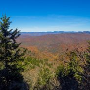
The doors opened, and the room filled — with hikers, bikers, ecologists, conservation workers, economic development professionals and Cherokee tribal members alike who were intent on making their voices heard during a public forum last week, which took input on plans that will impact the future of Waterrock Knob and the Plott Balsams.
“What I love is the passion that people bring to conversations like this,” said Leesa Brandon, spokesperson for the Blue Ridge Parkway. “Their love of these places, their hopes for the future and the fact that the (National) Park Service is here hearing that along with all of these other community partners — it makes me really excited for the resource.”
In August 2016, the Park Service announced that land donations from a quartet of conservation organizations would add 5,329 acres to the Blue Ridge Parkway at Waterrock Knob, and that announcement spurred efforts to plan for the future on a regional scale.
While the Waterrock Knob addition will represent the largest expansion of the Parkway in 60 years, it’s far from being the only piece of conserved land along its length. The stretch from Waterrock to Maggie Valley has drawn particular attention from a litany of conservation organizations, with blocks of conserved acreage — as well as undeveloped tracts of private land being eyed for conservation.
Planning for the Plott Balsams won’t be completely focused on future generations and future use, however. A key part of the planning effort will be deciding how to interpret the past — the settlers who scratched out a living in these mountains years ago and the Cherokee people who called them home for millennia before that.
The Lowcountry is an ideal place for anyone who loves the outdoors; visitors and resident alike enjoy the subtropical climate while biking, swimming, kayaking and golfing.
Both amateur and expert hikers can find many opportunities to hike in the Lowcountry, too. All a hiker needs is a pair of shoes and perhaps some company, and he or she is ready to walk through enormous oaks decorated with Spanish moss under the South Carolina sun.
Beaufort County has its fair share of trails. One of the longest trails — the Spanish Moss Trail — will eventually stretch 16 miles, connecting the Sands Beach in Port Royal to the Whale Branch River. So far, only 10 miles of the Spanish Moss Trail have been built.
But Spanish Moss isn’t the only trail in Beaufort County to offer picturesque views. Listed here are nine other trails in the county worth checking out. None of them are strenuous hikes, so even the littlest ones in the family can join.
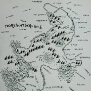
J.R.R. Tolkien’s The Lord of the Rings and The Hobbit are iconic fantasy adventures, and readers return to them time and again because of the rich detail that defines the world. Tolkien’s prose is aided by his beautiful maps of Middle-Earth, which comes with simplified, beautiful forests, mountains, and typography that has set the standard for fictional cartography ever since. That influence extends beyond just fantasy novels: an English artist is using Tolkien’s style to reimagine the UK’s national parks for his own beautiful maps.
Dan Bell says that he began reading Tolkien’s books when he was 11 or 12 years old, and fell in love with them. “The most appealing thing about them is that they allow your imagination to run wild.” In particular, he was struck by Tolkien’s maps.
“I love the detail, and the thought processes behind them.” Bell explains, and says that he began drawing his own copies of the maps. After receiving positive feedback from friends, he thought about adapting the art style to some real world locations, such as the UK’s national parks.
To start his maps, Bell says that he works from an open source Ordnance Survey map, and begins drawing by hand. “I try to emulate his typeface as closely as possible, but have modified his mountains in an effort to develop a little bit of my own style.” He adds in additional details, such as forests, Hobbit holes, towers, and castles.
In warmer months, it’s common to see a line of cars waiting outside Jones Gap State Park as early as 9 a.m. on the weekend. Jones Gap has only 36 parking spaces; when those are full, the park is considered “at capacity” and the gates close until more visitors can be accepted. With 415,852 visitors welcomed to the Mountain Bridge Wilderness area last year – a figure that has nearly doubled since 2014 – getting outdoors is getting harder to do. Now, the park’s capacity likely will get a sorely needed boost.
The Nature Conservancy has purchased 955 acres in northern Greenville County known as the Gap Creek property. The Conservancy plans to transfer the property to South Carolina State Parks in 2018 to be added to Jones Gap State Park. The Gap Creek addition will increase the size of the park by nearly 25 percent.
“Gap Creek is a dual gift for Upstate residents and visitors,” says Phil Gaines, South Carolina state park director. “Its 955 acres include flat land that is ideal for more parking, facilities, trail heads and other visitor amenities. This property can help the Park Service meet its vision for expanding visitor service and making this wilderness area accessible to more South Carolinians.”
Gap Creek has been a high conservation priority for decades because of its size, connection to other conserved lands and unique natural features. The property is home to healthy, contiguous hardwood forests that provide habitat for animals such as black bear, migratory songbirds and even bats. Headwater streams and a series of cascades on the property support cold-water fish, salamanders and frogs before eventually making their way to Saluda Lake.
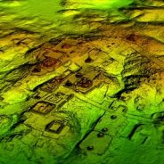
Researchers using a high-tech aerial mapping technique have found tens of thousands of previously undetected Mayan houses, buildings, defence works and pyramids in the dense jungle of Guatemala’s Peten region, suggesting that millions more people lived there than previously thought.
The discoveries, which included industrial-sized agricultural fields and irrigation canals, were announced by an alliance of US, European and Guatemalan archaeologists working with Guatemala’s Mayan Heritage and Nature Foundation.
The study estimates that roughly 10 million people may have lived within the Maya Lowlands, meaning that kind of massive food production might have been needed.
Researchers used a mapping technique called Lidar, which stands for light detection and ranging. It bounces pulsed laser light off the ground, revealing contours hidden by dense foliage.
The images revealed that the Mayans altered the landscape in a much broader way than previously thought; in some areas, 95% of available land was cultivated. The extensive defensive fences, ditch-and-rampart systems and irrigation canals suggest a highly organised workforce.
The mapping detected about 60,000 individual structures, including four major Mayan ceremonial centres with plazas and pyramids.
Following the blue blaze markers along the North Country Trail is a good way to stay on the trail, as is a good old-fashioned waterproof, tear-resistant paper map. A little technology, though, can’t hurt.
Matthew Rowbotham, the North Country Trail Association’s Geographic Information System coordinator based in Traverse City, also encourages accessing and using the NCTA’s online trail map as well as mobile apps.
The reason behind the NCTA’s online mapping efforts is to deliver trail users a unified mapping system and offer map content in as many modern popular platforms as possible — desktop computers, laptop computers, smart phones and the like.
The NCT is the longest trail in the National Trails System, stretching 4,600 miles seven states from the Vermont border of New York to the middle of North Dakota.
NCTA uses ArcGIS Online, a collaborative web GIS that allows people to use, create and share maps, scenes, apps, layers, analytics and data. A user can click on the “Launch the online map” button at northcountrytrail.org/trail/maps/ and get lots of helpful information.
While we certainly need periods of rest and relaxation to thrive, becoming relatively inactive for months on end is rarely a good idea for your health and well-being, especially when you’ve spent the past several months hoofing it to amazing hiking destinations and building up your strength and endurance.
The good news is there are many ways to take the next step in your hiking journey by staying in peak hiking shape throughout the winter months. That way, when warm weather returns and your favorite trails are accessible again, you’ll be strong enough to enjoy them.
To maintain your hiking strength and stamina, the most important thing you can do is simply stay active. That activity can come in many forms and will vary depending on your interests and comfort level. Whether you want to hit the trails, hit the slopes or hit the gym, there are plenty of effective methods for staying active, healthy and energetic during the dark days of winter. No matter which options you choose, you’ll thank yourself come spring.
By far, the most obvious way to stay in great hiking shape is to keep hiking. Many of our favorite high-country trails are buried under snow right now, and trudging through the white stuff may not be within your comfort zone. It may seem simple to say, but go lower. Find out what elevation the snow line is in your mountains, and find trails below that elevation.
The National Audubon Society’s Francis Beidler Forest located in Four Holes Swamp, South Carolina contains within its 18,000 acres the largest remaining stand of virgin bald cypress and tupelo gum swamp forest left anywhere in the world.
Wander along an elevated boardwalk that starts and ends at the visitor center past ancient trees, black water swamp, clear pools, and wildlife. Thousand-year-old trees and native wildlife abound in this pristine sanctuary that has been untouched for millennia.
A 1.75-mile self-guiding boardwalk trail allows visitors the chance to safely venture deep into the heart of the swamp… to experience the peace and serenity that have characterized the area for centuries… to hear the sounds of bird and bug and breeze that have echoed through the trees for ages… to take a relaxing and informative walk back into time… to see a swamp the way nature intended it to be.
Located in the heart of the South Carolina Lowcountry between Columbia and Charleston, Four Holes Swamp is a 45,000-acre matrix of black water sloughs and lakes, shallow bottomland hardwoods, and deep bald cypress and tupelo gum flats— and a major tributary of the Edisto River.
For thousands of miles America’s hiking trails wander across ranges and rivers, reaching basically every corner of the country. The 11 National Scenic Trails alone offer almost 20,000 miles of hiking opportunities.
So how exactly does one successfully navigate these long trails? Anyone who has set foot on the famous Appalachian Trail has undoubtedly seen several of the infamous “white blazes”. The blazes are, at their simplest, trail “markers” to keep hikers on the right path.
A traditional blaze is 2” wide by 6” tall and is painted on trees, fence posts, rocks, or anything else available nearby. They can also be found in plastic or metal nail-up versions or as adhesive decals for carsonite posts.
A general rule of thumb is a single blaze should be visible at all times to a hiker on a well-marked trail, maybe two depending on the layout. Over-blazing (more than 2 blazes visible from one spot on the trail at a time) is considered overkill and can be classified as form of visual pollution.
Interpreting the blazes to find your way along a trail is fairly straight forward. A single blaze by itself just indicates that the trail ahead is fairly straight or obvious and you are traveling in the right direction. A double blaze indicates a turn in the trail, with the offset blaze (the top one) indicating the direction of the turn. Two blazes directly on top of each other with no offset just simply means “pay attention”, something about the trail up ahead may not be obvious.
Each long trail designates their own color for marking the trail, the AT famously adopting white. Spurs or loop trails often have a common but different color as well, in order to distinguish them from the main trail.
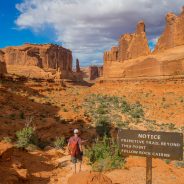
Arches National Park is 4 miles outside the small town of Moab, Utah. The park has over 2,000 natural stone arches and offers a variety of things to see, do and photograph.
With walks, hikes and drives ranging from 30 mins to a few hours, there is something to suit everybody.
The main scenic drive is a total of 43 miles and includes all spurs. Plan 2 to 3 hours to complete the drive. Add more time if you want to do any long hikes or serious photography. Most arches and landmarks can be seen from the parking lots and pullouts or a short walk.
Delicate Arch is always a must-see for most visitors since it is one of the most famous features in the world. The trail to see the arch up close is 3 miles round trip and climbs 480 feet in elevation.
Explore the narrow canyons and maze-like fins in the Fiery Furnace with a 3-hour, ranger-led hike. Advance reservations are necessary. The tour requires climbing over boulders, walking through sand, and navigating trails between rocks and along narrow ledges.
This post shares when is the best time to visit, where to stay, and points of interest including the best arches national park hikes to get you out and exploring the park.
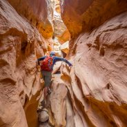
There is something magical and sobering about exploring slot canyons in Southern Utah.
Hiking, swimming and sometimes squeezing through high sandstone walls carved by the elements over thousands of hundreds of thousands of years makes you keenly aware of how powerful the natural world around us is.
Don’t worry though, if the thought of squeezing through a 10-inch crevice 100 miles from civilization inspires panic like that time your brother zipped you into your sleeping bag while he watched Saturday morning cartoons, there are plenty of incredible slot canyons like the Zion Narrows that don’t require any squeezing.
For the thrill seekers out there, there are several options to bring your rope and harness for some canyoneering.
Whatever your speed is, a day spent exploring the cool, winding depths of any of these Utah slot canyons is one you won’t regret.
A new hiking trail climbs the eastern edge of Prentice Cooper State Forest, ascending more than 1,000 feet with two main water crossings and several smaller ones sprinkled throughout. The climax of the rocky hike comes in the final mile: a 30-foot waterfall that rains down before the trail connects to the Cumberland Trail System’s Pot Point Loop.
The “moderately strenuous” 2.5-mile Ritchie Hollow Trail connects the Tennessee River to the top of Suck Creek Mountain. It opens with an 11 a.m. ceremony and hike Saturday at the trailhead near Pot Point Cabin.
The project adds to the growing trail network in the area and gives hikers a more advanced hiking opportunity. That’s something the Southeast Conservation Corps believes the area could use. The corps helped build the trail. The group did much of the technical work that would have been too difficult for most volunteers. For instance, the group helped create a path through a rock garden.
The trail goes through a historical moonshine-making area. Several moonshine stills remain in the woods along the trail and can be seen on the hike. Eventually, the corps wants to add more signs to highlight the history.
Plans are in the works to extend the trail later this year to Davis Pond campground and parking lot. That will give trail access at both the top and bottom of the mountain.
Are you au fait with Ordnance Survey? Know how to read a six figure grid reference? If you were left on a moor with just a compass and a map would you find your way home safely or wander aimlessly, eventually getting eaten by wolves?
The Royal Institute of Navigation are concerned about the nation’s cartographical know-how and have suggested schools start teaching basic navigation to address the issue.
They believe we’re all too reliant on technology, expecting smartphones and satellite navigation systems to do the hard work for us and becoming “sedated by software” in the process.
“It is concerning that children are no longer routinely learning at home or school how to do anything more than press ‘search’ buttons on a device to get anywhere,” Roger McKinlay, president of the Royal Institute of Navigation said.
“Many cannot read a landscape, an Ordnance Survey map, or find their way to a destination with just a compass, let alone wonder at the amazing role astronomy plays in establishing a precise location.”
“Instead, generations are now growing up utterly dependent on signals and software to find their way around.”
Seen from above, Egypt’s Sinai Peninsula is a dun-colored triangle of desert, a vast wedge that splits Asia from Africa.
Move in closer, and the desert resolves into a landscape of high peaks and sandy valleys, dunes and rocky peaks.
Tracing a route across that terrain is the Sinai Trail, Egypt’s first long-distance hiking path, which was established in 2015 and winds roughly 143 miles from the Gulf of Aqaba into the mountainous interior.
This past November, 17 men and women undertook a 14-day thru-hike of the Sinai Trail, the first crossing of the full length of the trail. Led by male members of three Bedouin tribes and an Italian organizer, the group was as varied as the topography, a convivial assortment of novice hikers and fit backpackers, mainland Egyptians and foreigners.
They started near the Red Sea community of Beer Sweir, climbing the Sinai’s coastal mountains with hazy views of Saudi Arabia at their backs. After two weeks of hiking, their travel reward was a frosty 6 a.m. sunrise from the slopes of Mount Katherine, the highest mountain in Egypt.
The Sinai Trail crosses the territories of three Bedouin tribes – the Tarabin, the Muzeina and the Jebeleya – pastoral nomads whose lives have traditionally been shaped by the search for rain-fed grazing land and other desert resources, and who have guided Sinai travelers for generations.
Some of the best photographic opportunities happen when you least expect them. In this video see valuable tips on how to always be prepared for the surprise wildlife photo of a lifetime.
The first step for capturing any split second rare image is to have your camera out of the bag and turned on. Perhaps you’ve been guilty of coming upon wildlife in perfect light on a hike but your camera was stored away in your bag.
When this situation occurs it’s even more difficult to get set up because you have to move very slowly in order to not scare the animal away. And as you can imagine, by the time you get the camera out, turned on, dials set for the scene, and perhaps mounted on a tripod, you’re pointing the lens at an empty landscape.
The author suggests having your camera default settings optimized for the “worst case scenario.” He describes this as the times when there is very little light to work with and wildlife pops out.
This means having your ISO at the limit of acceptable quality for the camera, aperture is set wide open, and the shutter speed dictated by aperture-priority mode. The resulting image may not be technically perfect, but with your camera at the ready, there’s at least a chance you’ll get something incredible instead of fumbling with gear and enjoying neither the moment with an animal or any photo to take home.
Mountainous Kumano is the holy ground of Japan and pilgrims have been trekking there for centuries. Shrines, mist, forests and waterfalls combine to create an entrancing hike.
Kumano is the traditional name for the southern part of Japan’s Kii peninsula. It contains pilgrimage routes dating back more than a millennium. The first pilgrims were adherents of Shinto who traveled to worship beside the natural wonders of the sacred Kii mountains. Later pilgrims followed an amalgam of Shinto and Buddhism.
The Kumano Kodo has a low profile outside Japan; the Camino de Santiago in north-west Spain is much better known, but that is changing: more visitors are coming to walk it, Unesco has designated it a world heritage site and it has been twinned with the Camino de Santiago.
There are a variety of routes to choose from and treks often take between three and six days. Go for three days on the Nakahechi route, the most popular of the six main historic trails. The most demanding is the 80km Omine-Okugakemichi route: suitable only for expert hikers with mountaineering experience. Another route is a total of 15km through a wide range of terrain, some of it quite challenging. It is a pick-and-mix experience; you can walk as little or as much as you like, because buses run between many points on the trail network. Guides are available but most trekkers are self-guided.
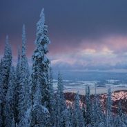
Northwest Montana is famous for its unmatchable beauty in the summer, but winter offers its own kind of magic. Mother Nature starts with a bare canvas by throwing down a snow blanket to hide the melancholy of landscapes drained of color and strewn with shriveled gardens and fallen leaves. She then constantly rearranges and redecorates, refreshing the landscape with each snowfall, like a newly painted room.
Intricate ice trinkets dangle from logs and rocks, while glistening sheets of ice cover lakes. Hoarfrost’s delicate petals and feathers form winter floral gardens, and the wind and sun carve new patterns into snow and ice.
Winter presents its challenges: mustering enough time, energy and desire to play in the snow after you dig yourself out of your driveway or chip ice off your windshield, for starters. But romping in snow will make you love winter more.
If you don’t snowshoe, skate, ski or ice fish, just tug on your warmest boots and find a country road, a quiet wildlife refuge or a place with low snowpack and go exploring in the woods. Winter is a mysterious time, with delightful surprises around every corner, from the delicate frost that flutters on a blade of grass to the varying textures and shapes of lake ice and the snow-covered evergreens set against crystal-clear blue sky.
Here are just a few of winter’s many magical wonderlands…
 I am Jeff Clark, founder of Internet Brothers, producer of this blog, and passionate about hiking. I live in Western NC near the Blue Ridge and Great Smoky Mountains. Pisgah and Nantahala National Forests are just out my door, so the content will focus on these areas, but let me know what you would like to see on the site.


Copyright © 2011-2023 Internet Brothers. All Rights Reserved. ISSN 2324-6057
Designed by Elegant Themes | Powered by Wordpress | Logo by Design Aspirations