The eighth class of Appalachian Trail Hall of Fame honorees will be inducted on Friday, May 4, 2018 during the annual Appalachian Trail Hall of Fame Banquet at the Allenberry Resort in Boiling Springs, PA.
The 2018 Appalachian Trail Hall of Fame class honorees are William Kemsley, Jr. of Taos, New Mexico; the late Elizabeth Levers of New York, New York; the late George Masa, of Asheville, North Carolina; and Robert Peoples, of Hampton, Tennessee.
There was no one publication that spoke to the needs of backpackers until Bill Kemsley started Backpacker Magazine in 1973. At Backpacker, he published numerous articles and editorials on the Appalachian Trail.
Elizabeth Levers was known as the “Mother of the A.T.” in New York state. She was known for her key activity in the early land acquisition planning for the A.T. in New York as well as setting the standard for AT management for that region.
George Masa was a photographer in Asheville, North Carolina early in the 20th century, and his nature scenes were instrumental in garnering support for the creation of the Great Smoky Mountains National Park.
After retiring from the U.S. Air Force in 1988, Bob Peoples decided to devote his life to hiking trails. He initially helped to maintain the Long Trail in Vermont, a portion of which is also the A.T.
Sen. Lamar Alexander has introduced a bipartisan bill to help address the $11.6 billion National Park Service maintenance backlog.
The National Park Restoration Act would use revenues from energy production on federal lands to rebuild roads, buildings, campgrounds, trails and water systems in national parks across the country.
The Tennessee Republican said the main principle of the proposed legislation is to create an environmental benefit from an environmental burden.
“If you place a burden on the land, which energy exploitation does, then you ought to put a benefit on the land,” he said.
In fact, Alexander said the bill over 10 years could potentially eliminate the entire maintenance backlog in the national park system, including the $215 million backlog of projects in Great Smoky Mountains National Park.
“That is the best news for Great Smoky Mountains National Park in a long time,” said Alexander, noting that several maintenance projects in the Smokies have been on hold due to lack of funding.
The 170-mile-long Tahoe Rim Trail passes through three wilderness areas and two mountain ranges as it takes hikers from 6,200 feet to higher than 10,000 feet in elevation. In the Desolation Wilderness, you find pristine alpine lakes and granite peaks, in Meiss Meadows, you stroll through hip-high fields of wildflowers, and at the base of Tahoe’s highest mountain, Freel Peak, there is a mountain of quartz and Star Lake, the highest lake in the Tahoe region. But what you will remember the most is the mile-after-mile views of Lake Tahoe. The trail is your chance to see Tahoe from every angle, and all of them are beautiful.
The best part about thru-hiking the TRT is that the trail is an enormous circle. Wherever you start, if you just keep walking in the same direction you will return to where you began. As you work your way around the lake, you can always measure where you have hiked from, and how far you still have to go.
The trail crosses roads in a number of locations making resupplying easy, and with water scarce in some locations, a resupply usually means water and food. The interesting thing about camping on the rim trail is that, except for the few days that you are in Desolation Wilderness, the vast majority of trail users are day users.
Thru-hiking the rim trail by yourself is challenging, but it’s a doable adventure for any relatively strong hiker. You need two weeks, friends to drop off food and water at several key points and a good deal of perseverance.
Sand to Snow National Monument is a quiet place — its mountainous high desert and cascading streams a draw for those seeking panoramic views, tranquillity and solitude.
But on a recent morning, the serenity was ruined by a menacing bellowing, making it clear passing hikers weren’t alone.
On a ridgeline near a popular stretch of the Pacific Crest Trail, five feral bulls, each the size of a small car, were snorting, stomping and pawing the ground — postures indicating they were ready to charge.
The bulls gazed down on human observers; some lowered their foot-long horns. Then they lumbered on, trampling the trail and devouring native vegetation in one of California’s newest national monuments.
They are part of a herd of at least 150 that’s ripping up this monument and scaring the heck out of folks who cross paths with them. Signs posted at trailheads warn of an additional danger. A pack of pit bulls has been killing and eating the wild cattle in this nature sanctuary.
Jack Thompson, desert regional director of the adjacent Whitewater Preserve, roughly 10 miles northwest of Palm Springs, was only half-kidding when he said, “It’s Jurassic Park just a two-hour drive east of downtown Los Angeles.”
As the cold winter air turns milder and snow melts from the streets, those sitting inside throughout winter might be itching to get out and go on a hike.
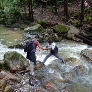
“With spring hiking, there’s a handful of additional risks and there’s items that I recommend people take to mitigate those risks,” said Wesley Trimble, program outreach and communications manager for the American Hiking Society.
Trimble recommends doing some research before hitting your desired trail. National forest offices, land managers or even local offices can be a great source of information about trail conditions that tend to be more unpredictable in the spring.
In particular, creeks and rivers flow higher and faster in the spring than any other time of the year due to snowmelt.
The early springtime creeks and rivers can be more dangerous. Trimble recommends doing research to check if there are creeks or rivers that are on the desired trail and whether or not it is safe to hike at that current time.
Before you hit the trails or pack your backpack, make sure you know the eight risks that face spring hikers.
Vladimir has seen more of the U.S. than most Americans. For the past two years, he has visited 50-plus national parks, traveling in a renovated 1989 Toyota motor home with Cees and Madison Hofman and their infant son.
He goes kayaking, hiking and rappelling. Between adventures, he naps, eats and watches the passing scenery out the RV window. He never has to pitch in for gas. As the Hofmans’ cat, Vladimir is excused from sharing the wheel or any other chore of road travel.
American pet owners are taking their cats to the great outdoors, packing kibble, litter boxes and a leash with the rest of the camping gear. For them, the road dog is the family cat.
While most pet cats seldom stray from the comforts of home, these so-called adventure cats are finding their way back into the wild.
To make sure curiosity doesn’t kill the cat, adventurous owners tuck their pets in hiking backpacks—some specially made for pets—or stow them in the prows of kayaks. The most important accoutrement is the leash and harness.
Trying to leash train a cat is tough, time-consuming work, as anyone who’s tried knows. Yet it is a threshold skill for adventure cats, which are prone to darting off trail if left to wander untethered.
After another record year in 2017, backcountry managers with the Great Smoky Mountains National Park are asking visitors to consider ways to enjoy the park while minimizing their impact.
With overall park visitation and Appalachian Trail hiking both growing, the number of people entering the park has grown significantly.
“2017 in terms of thru-hikers, we saw the most thru-hikers come through the park on record,” backcountry management specialist Christine Hoyer said. “2015, 2016, 2017 – each year is the new record.”
Hoyer says around 4,400 hikers passed through the park in 2017. Combined with other backpackers staying at campsites and shelters, visitors spent the night at backcountry facilities more than 104,000 times in 2017.
“Our shelters on the ridge line have a capacity of 12 to 14. In the 70s, they held four spots open for thru-hikers during the height of thru-hiker season to accommodate that use,” Hoyer said. “When they built those shelters, when they used that limit, they would’ve never imagined how many we have coming into the park every day during the height of thru-hiker season.”
Hoyer says more than 50 thru hikers enter the park at Fontana Dam each day during peak times. Seven of the ten most popular backcountry sites in the entire national park are on the Appalachian Trail and the popularity causes crowding.
The Appalachian Trail Conservancy is an interesting animal in that, not unlike the huge trail itself, it links together a lot of varied parts. The nonprofit is a cooperative of local, state and federal government agencies, and 31 local organizations looking after a footpath that spans 14 states and more than 2,000 miles.
As you can imagine, working across that many geographies and entities on such a large task warrants some serious fundraising to provide connective tissue. As with other groups sticking up for treasured public lands, the conservancy has been working to bump up its fundraising, and recently landed a $3 million grant from a Virginia family foundation.
That’s a pretty big score when it comes to trails philanthropy. Then again, the AT is not just any trail, running from Georgia to Maine and serving some 3 million hikers a year. The latest grant will fund efforts to protect the trail’s lands, waters and cultural features, as a large component of the conservancy’s mission includes land protection, management and other conservation efforts for its more than 250,000 acres of public lands.
This big grant for the Appalachian Trail comes amid a surge of philanthropic giving for parks, plus a notable increase in private funding toward the National Park Service from individuals, foundations and corporations alike. We’ve also seen some pretty big giving for trail systems.
Of course, while donors are willing to step up, there is a dark backdrop to such donations, as protections are gutted by Ryan Zinke’s Department of the Interior, leaving public lands more vulnerable than they have been in many years.
If you have ever driven to Las Vegas on Interstate 15 from Southern California, then no doubt you have stopped in or rolled by the small town of Baker, known as the Gateway to Death Valley. It’s also home to the World’s Tallest Thermometer and the Mad Greek, a great place to get some road food as well as fresh strawberry shakes. There are more and more new places opening, like Alien Fresh Jerky, but gas and food is the most there is to see.
After filling up your vehicle (best to get gas when you see it as it’s much cheaper here than in the park), head north on Death Valley Road (State Route 127) for about 50 miles of pristine two-lane desert highway that passes the Dumont Dunes before arriving at China Ranch Date Farm.
Located just south of Tecopa, the road to the farm winds down through desert cliffs for about a mile before a lush, green oasis appears out of nowhere. Open every day from 9 a.m. to 5 p.m., this family-run ranch has miles of hiking trails to the Amargosa River and abandoned mines, plus the Old Spanish Trail.
It also has an excellent variety of dates, including their own hybrid varieties that are some of the best there are. There is a museum and store full of handmade gifts as well as date shakes, muffins, date bread and cookies that are all made fresh daily.
Furnace Creek Visitor Center is the best place to start your Death Valley adventure. Here, you can pay your park fee and talk to a ranger, get maps, books and gifts, and learn about the history of the area. Death Valley is home to many ghost towns, mountain ranges, abandoned mines, sand dunes, craters and some of the most beautiful desert vistas you will ever experience. This is a must stop for all visitors to get the most up-to-date conditions of the park.
A new hotel that’s hoping to attract hikers to the Italian hills in South Tyrol has been built to seamlessly blend into the surrounding countryside. The Hotel Bühelwirt in South Tyrol, Italy has recently been reconstructed with a beautiful dark exterior and large windows offering breathtaking views of the surrounding mountains and forest.
Every one of the 20 rooms in the hotel features panoramic views and were designed with the purpose of keeping guests connected to the alpine landscape. The dark wooden exterior belies the bright spacious rooms inside, that start from a reasonable £50 ($69) per night.
Pedevilla Architects designers of the hotel upgraded it from a traditional hiking hotel. “The hiking hotel is located on the “Bühel”, a small elevation right next to the village church, at 1200m above sea level.”
“The green shade of the blackened wooden facade is influenced by the dark-green, or often black forest tinge, which seem to blend nature and topography with the building. The larch wood from the surrounding forests provides a sense of comfort.”
Specially selected and locally sourced materials generate a familiar and cozy atmosphere according to the designers, and with that in mind every room is simple in layout, each having a window seat to admire the view, and a handcrafted copper lamp from a local artist along with curtains in a natural material made in a nearby factory.
Five miles into his 2,200-mile hike, Tom Abel was welcomed to the Appalachian Trail by pelting quarter-inch pellets of hail. The 15-minute storm of stinging ice missiles would not be all that Mother Nature had in store for the 68-year old during his six-month journey from the summit of Mount Katahdin in Baxter State Park, Maine, to the summit of Springer Mountain in Georgia. As he quickly discovered, hiking through hail, high water, heat waves, and snow would all be required to reach his long-held goal of hiking the entire Appalachian Trail.
Thousands of hikers endeavor to complete the demanding expedition each year. Only one in four succeeds. As it happens, Abel completed the thru-hike on his first attempt. Having thought about hiking the entire trail since his post Air Force college days, the retired geologist’s opportunity finally came, a few years after retirement.
On May 31, Abel and his wife, Becky, flew to Maine. The next day, Abel began the hike that would take him almost six months to complete. Although Abel admits that his best training actually happened on the trail, where he spent entire days after days hiking, he had devoted the months prior to his venture by preparing his body for the anticipated terrain.
“I went to the gym three days a week and used the stair climber and treadmill at maximum incline. I also went to Carter Road Park once or twice per week and hiked the trails with my loaded backpack. In May of last year, my eldest daughter and I hiked into the Grand Canyon from the rim to the Colorado River, where we camped one night, then hiked out the next day. Also last year, I hiked up Mount Katahdin, Hump Mountain in Tennessee and North Carolina, Springer Mountain via the Amicalola Falls State Park approach trail, Clingman’s Dome in the Smoky Mountains National Park, and Pico El Yunque in Puerto Rico,” Abel said.
His disciplined training was wise considering his intended completion of 10 miles per day, atop varied terrain, through diverse weather conditions, and while carrying a 25 to 30-pound backpack.
The U.S. Forest Service hopes to double the workload of its volunteer helpers as it attacks a backlog of trail maintenance largely in Montana.
The Bob Marshall Wilderness Complex’s 3,200 miles of trail arrived No. 1 on a Forest Service priority list for trail work. So did the Continental Divide Scenic Trail; its largest segment passes through Montana. And the Central Idaho Wilderness Complex listing includes a chunk of the Bitterroot National Forest slopping across the Montana-Idaho border.
But no money was attached to any of these priority areas. Instead, the Forest Service is following the National Forest System Trails Stewardship Act of 2016, which commands the agency “to increase trail maintenance by volunteers and partners by 100 percent” within five years of enactment.
“The fundamental problem is the Forest Service is underfunded,” said Bob Marshall Wilderness Foundation Director Carol Treadwell. “They’re probably frustrated too by an act passed by Congress outside of their advice, and now they need to implement it when what they need is funding to fill the gaps. Instead they get mandate from Congress to find more volunteers out there.”
BMWF does exactly that, providing volunteers for about 40 backcountry repair projects a year for the past 20 years.
Ed. note: the same is true of national forests all across the country. If you value your favorite hiking trails on national forest public lands, look for your nearest “Friends” group and volunteer to help out. It is very rewarding.
A Port aux Basques, Newfoundland man continues to combine his love of the outdoors with his respect for fallen soldiers.
Colin Seymour is ready to place 158 yellow ribbons – one for each Canadian soldier who lost their life in the war in Afghanistan – along the hiking trail leading to Mark Rock Mountain, just outside South Branch, where a monument honors Sgt. Craig Gillam of that community. Gillam died in Afghanistan on Oct. 3, 2006. He was 40 years old.
When Seymour, his wife Cindy and family friend Donna Stuckless tried to hike the trail and visit the monument in August 2015, they found it had grown in so much they couldn’t get near the top of the mountain.
Seymour returned to the trail alone, determined to make his way to the monument. It would be his first of many trips.
“I picked my way up through the woods… originally, they’d put out (over 140) yellow ribbons to mark the trail,” he said, referring to the ribbons commemorating soldiers who had lost their lives in Afghanistan when the monument was first erected in Gillam’s memory. Remnants of those ribbons are still there, he said.
With the permission of Gillam’s family, Seymour has made a new wooden cross for the monument to replace the original one that had withered with time.
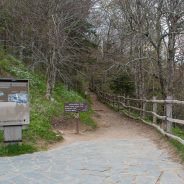
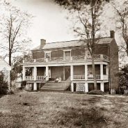
For more than 40 years, visitors to the Appomattox Court House National Historical Park have walked among the ghosts of history over seven miles of trails through the park’s historic village and interpretive sites.
The park now is seeking public input for plans to expand the current trails to create a comprehensive, site-wide trail system. Appomattox Court House National Historical Park Superintendent Robin Snyder said plans are to add about two miles to the existing system, which serves about 75,000 visitors annually.
“The whole purpose is to provide better visitor access in the park,” she explained. “We have great stories, and this would enable people to get out to areas they haven’t seen before.”
Many of these important anecdotes are not part of the current trail system, so they may be unknown to visitors, according to Appomattox Court House National Historical Park Natural Resource Manager Brian Eick. Some of these accounts include the last fighting on the morning of the surrender and the site where Hannah Reynolds, an enslaved woman and the only civilian casualty of the Battle of Appomattox Court House, was wounded.
The park, which is located in Appomattox County, Virginia, covers 1,770 acres around the site where the Confederate Army surrendered to the Union Army in April 1865, effectively ending the Civil War.
Hugh and Jean Joudry have spent the last fifty summers atop Stratton Mountain, and the couple, now in their seventies, aren’t planning to descend any time soon.
While their tenure at the mountain’s summit began through the State of Vermont’s Fire Watch program in 1968, the two have watched over the peak as Green Mountain Club caretakers since the 1970s. Over the past decade, however, funding for the Joudry’s and other caretakers along the Long Trail and Appalachian Trail has begun to decline — as the amount of hikers passing through continues to increase.
“We’ve always worked on top of Stratton Mountain,” said Jean Joudry. “In the early years we saw very few people; almost no one. Last year we saw over 8,000 hikers.”
Those hikers have an ecological impact, she says, and caretakers are often responsible for providing education on “Leave no Trace” practices, conducting basic trail and campsite maintenance and leading backcountry waste management.
According to GMC’s Manchester Section Director Marge Fish, many of the trail’s ponds and summits can be denigrated by the unregulated camping that occurs without caretakers like the Joudry’s.
Though the bulk of the $60,000 program in the Green Mountain National Forest has historically been funded by the U.S. Forest Service, says Fish, those numbers have declined over the past decade, largely because of shortages in the Forest Service’s own budget.
“They have been trying really hard to come up with at least some of the money,” Fish acknowledged. “This year we were told that the Forest Service’s funding could be chopped off at the knees, which is not a surprising thing out of this government.”
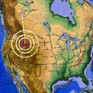
Something is rocking the massive supervolcano beneath Yellowstone National Park.
Thanks to a recent earthquake swarm, the Yellowstone supervolcano has seen upwards of 200 quakes since February 8, 2018 along with countless smaller tremors. The largest earthquake was an unremarkable magnitude 2.9, and all of them have hit about five miles beneath the surface. Larger earthquakes have rocked the region in the past, some as destructive as the Hebgen Lake quake and others causing minimal damage.
With this most recent swarm, scientists say there’s no reason to worry. “Supervolcano” and “earthquake swarm” might seem like daunting terms on the surface, but in Yellowstone National Park, these geologic features are relatively nonthreatening.
Earthquake swarms occur when a single area experiences an increase in quakes over a short period of time without the trigger of a single, larger “mainshock.” Swarms can result from changes in stress along fault lines, which can be caused by either large-scale tectonic forces or pressure buildup due to changes in magma, water, or gas underneath Earth’s surface.
The area where this current swarm is happening—about 8 miles northeast of West Yellowstone, Montana—is under pressure from both these forces, since Yellowstone is a hotbed for seismicity. But earthquake swarms are frequent in the region, accounting for more than half of the parks’ seismic activity. And they haven’t triggered any volcanic eruptions yet.
Last year, a swarm ten times larger than the current one rocked the same region, generating about 2,400 earthquakes between June and September 2017. This year’s swarm could actually be just a continuation of last year’s, since seismic activity in the area can be sporadic but ongoing.
The site of Cave Creek Regional Park has a storied history.
Before there were hiking trails, campgrounds and picnic ramadas, the park, north of Phoenix, and its surroundings were used by the ancient Hohokam people, mine operations, farms and ranches. Yet the park’s relics of human endeavors are transient compared to its geological features.
Although the 2,922-acre site has been picked over by prospectors in search of gold deposits that never quite materialized, the peaks, gullies and bizarre curiosities borne of Earth’s disruptive forces remain basically unchanged since before humans arrived.
Taking a moderate loop stroll on the Slate, Quartz and Go John trails reveals a wonderland of rock while staying (mostly) away from the park’s busiest routes. More Arizona hiking here.
During the first stretch, minor outcroppings of vertical-tilted metamorphic rocks — the “slate” — begin to pop up along the trail. Then, just beyond the half-mile point, the scaly gray slabs take center stage. The outcroppings balloon in size, running amok on and around the route. Patches of paloverde and ironwood trees provide a little shade, but mostly, this hike is open to the sky.
Instead of Velcro, buttons, and snap fasteners, magnetic closures are now the trendy alternative for fastening phone cases, gloves, jackets, hoods, and other outerwear. But this seemingly innocuous design feature can actually put your life at risk.
A recent incident involving a group of lost hikers and an intense mountain rescue mission could have been avoided had it not been for a misplaced compass and a phone case with a magnetic closure.
“[The compass] had been stored in a pocket next to a mobile phone in a case which had a magnetic closure on it,” a safety advisor said, “and the magnet had reversed the polarity of the compass needle, so that the north arrow pointed south.”
Mountaineering Scotland says that this reversed polarity occurs when a magnet comes into contact with a compass, and that needles can be deflected briefly, partially, or completely. If the compass has been partially reversed, the needle will move slowly, stick, or be out of balance. It is totally reversed if the north arrow points south, as was the case with the hikers in Scotland.
Consider bypassing the magnetic trend and instead opt for clothing and phone cases with traditional fasteners to prevent a potentially risky situation on your next hiking expedition. Keep your compasses separate from your phones, phone cases, and other electronic devices, and perhaps carry a spare compass in case it breaks.
 I am Jeff Clark, founder of Internet Brothers, producer of this blog, and passionate about hiking. I live in Western NC near the Blue Ridge and Great Smoky Mountains. Pisgah and Nantahala National Forests are just out my door, so the content will focus on these areas, but let me know what you would like to see on the site.


Copyright © 2011-2023 Internet Brothers. All Rights Reserved. ISSN 2324-6057
Designed by Elegant Themes | Powered by Wordpress | Logo by Design Aspirations