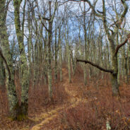
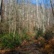
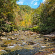
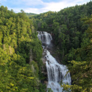
Quite frequently in winter, the Blue Ridge Parkway will be closed for snow and ice. Not great fun for those who wish to drive along the beautiful ridges. Ah — but it’s the perfect time for hikers to get out on the trails that parallel the Parkway — like the Mountains to Sea. Between Pigeon Gap and Bennett Gap at miles 412-414 the Mountains to Sea Trail traverses a ridge that crosses Green Knob, a 5,000 footer that splits Haywood and Transylvania counties. South of Green Knob is the Parkway itself, as well as the Cradle of...
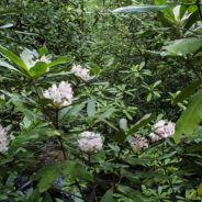
read moreThe Black Balsam area of Pisgah National Forest is surrounded by Middle Prong Wilderness on the west, and Shining Rock Wilderness on the east. Some of the best hiking found in Western North Carolina lies in this high country just north of the Blue Ridge Parkway. At the end of Black Balsam Road at milepost 420 on the Parkway, the Ivestor Gap Trail will take you deep into this rugged, untamed backcountry. There are lots of spur trails used by the seasonal blueberry pickers that wind through the hollows and across the ridges. There is also the...
read moreBetween mileposts 423 and 424 on the Blue Ridge Parkway, Scenic Hwy 215 crosses at Beech Gap. If you head about 1/4 mile north on 215, the famous Mountains to Sea Trail crosses from the Black Balsam area into Middle Prong Wilderness. The MtS winds through an ever-changing forest that runs the gamut of evergreens found in the high country of Western North Carolina. Past waterfalls and streams, through thickets and meadows, surrounded by 6000 foot tall mountain peaks, with the always present aroma of pine and spruce and fir, this stretch of the...
read moreGreen River Game Lands, southeast of Hendersonville, NC, sits astride the Henderson/Polk County line. Paralleling the Green River Gorge, the Game Lands is a state owned tract of more than 10,000 acres with 16 miles of hiking along nine distinct named trails. As its moniker would imply, hunting, fishing, and trapping are allowed on the Game Lands during the months of September through May, so hikers should definitely be alert and wear blaze orange, or hike on Sunday when the hunters aren’t around. Trails follow a rugged terrain of steep...
read moreJust southeast of the Cradle of Forestry in Pisgah National Forest lies the Avery Creek area, a beautiful hardwood forest with plenty of water and a hidden pair of waterfalls known as Twin Falls. Access to the falls is via the Buckhorn Gap Trail, an easy to moderate track that first follows Avery Creek, then turns north alongside Henry Branch. The forest management work in the area by the U.S. Forest Service is superb with “two-age cut” that makes it gorgeous even when the leaves are down. This hike occurred on Thursday, November...
read moreHickory Nut Gorge runs from Bearwallow Mountain in the northwest to Lake Lure southeast. Included in its 10-mile length are majestic cliffs of granite, inspiring waterfalls and scenic wilderness that beckons to the explorer in you. Chimney Rock State Park, Florence Nature Preserve and Rumbling Bald all offer excellent hiking within the gorge. Up in the northwest corner is a lesser known area called Hickory Nut Forest with trails that follow Hickory Nut Creek to Cascade Falls, and then on up Little Bearwallow Mountain to a tall bluff with a...
read moreDeep at the southern tip of DuPont State Forest is an area loved by mountain bikers, but also a nice place for scenic forest, riverside, and small mountain hiking. The elevation is in the 2800-3000 foot range, so it’s ideal for winter hiking where you’re not likely to get deep snow like the 6000′ peaks in the nearby national forest. Start with a lovely forested hike around Burnt Mountain, then follow calm, meandering Little River as it heads toward the exciting waterfalls downstream. Finish your day with a climb up Cedar...
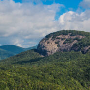
read morePilot Rock is another of the granite plutons found in the Pisgah Ranger District of Pisgah National Forest. Not as spectacular as it’s more famous cousin, Looking Glass Rock, Pilot still offers remarkable views of the Blue Ridge Parkway and national forest, including the Cradle of Forestry National Historical Site. It’s a short mile climb of almost 700 feet from the valley floor to the southern face of Pilot Rock. The forest changes along the way; from birch saplings to oak and maple, and the omnipresent laurels that embrace...
read moreThink of Wilson Creek as Linville Gorge lite. A long, rugged wilderness gorge running from the nearly 6000′ mountain peaks at its north, Wilson Creek shares many similarities with its bigger brother to the west. Wilson Creek was named a National Wild and Scenic River in August, 2000. The gorge area is a haven for recreation including hiking of course, but also fun for kayaking, camping, fishing, tubing, you get the picture. There are dozens of trails throughout the recreation area, including this one that follows the upper reaches of...
read moreOne of the highlights of the Wilson Creek Wild and Scenic River area is Harper Creek Falls. Located in the Grandfather Mountain Ranger District of Pisgah National Forest, this three-tiered falls is a fun place to swim, slide and dive — but the rugged terrain makes for a difficult and dangerous access. The Harper Creek Trail is easy enough. With the exception of a 200 foot ascent from the trailhead, most of this trail follows Harper Creek as it makes its way through the wilderness to an appointment with Wilson Creek. Once you reach the...
read moreThe always popular Cat Gap Loop Trail is a jumping off point for many great hikes within the Davidson River area of Pisgah National Forest. Included among them is the picturesque John Rock, one of the area’s plutons that stand over the recreation area. With views of the Fish Hatchery, Looking Glass Rock, Pilot Mountain and the ridges that run to Graveyard Fields, John Rock is a great spot for scenic vistas on your way around the Cat Gap Loop. This is a complete hike. In addition to the great views on John Rock, the trail follows two...
read moreAnother of the myriad of ridge and gap trails from North Mills River to the Blue Ridge Parkway. Bad Fork Trail follows its namesake creek from Forest Road 5000 to Bent Creek Gap at mile 400 on the Parkway. This is a four mile round trip that can be extended by continuing on the Mountains to Sea Trail on the north side of the Parkway. Only moderately steep, this is a nice leg stretcher that doesn’t take very long to complete. Look for laurel blossoms in the spring and views through the trees in winter. Our hike occurred on Thursday,...
read moreSection 1 of the Art Loeb Trail is in Pisgah National Forest near Brevard, NC overlooking the Davidson River Recreation Area. The North Slope Trail is a loop contained within the boundary created by the Art Loeb and the river. Between the two trails is a connector. Combining the two via the connector makes an 8-mile loop that takes in a large portion of the forest above the river. Dense and damp in summer months, the mostly deciduous forest gets a lot of rainfall and remains green well into mid-autumn. The Davidson River Campground is nearby,...
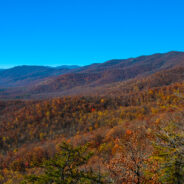
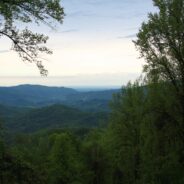
read moreNamed after the Biblical mount where Moses first saw the Promised Land, Mt. Pisgah is the landmark that gave Pisgah National Forest its name. Located on the border of Buncombe and Haywood counties in NC, close to the point where Transylvania and Henderson meet them, the mountain is easily accessible via a hiking trail from the Blue Ridge Parkway. Mt. Pisgah is topped with the Asheville-based broadcaster WLOS-TV tower, so it is always identifiable even from long distances. From the summit spectacular views of the surrounding Blue Ridge...
read moreCrowning the Mount Sterling Ridge, 5842 foot Mount Sterling is another of the tall peaks that give the Great Smoky Mountains their character. Located in the far eastern area of the national park in North Carolina, the 7-mile Mount Sterling Ridge rims the scenic Cataloochee Valley to the southeast. There are trails to the summit of Mount Sterling from every direction, but the shortest and steepest begins at Mt. Sterling Gap on the east side. This six mile round trip climbs nearly 2000 feet through the type of dense mixed forest that Great...
read moreHidden deep in the woods between Courthouse Ridge and Brushy Ridge in western Pisgah National Forest, Courthouse Creek makes a dramatic plunge through a narrow chute into a natural amphitheater of bedrock, cascading 45 feet into a cold crisp pool. Courthouse Falls is one of the best kept secrets in the “Land of Waterfalls.” Beautiful for its solitude as well as its picturesque setting, Courthouse Falls is reachable by trail or by forest road. The Summey Cove Trail is a 5-mile round trip that begins north of Balsam Grove on Scenic...
read moreLocated in the Bent Creek area west of Asheville, the Lake Powhatan Recreation Area is a suburban fun place for family activities including hiking, biking, fishing, swimming and jogging. Adjacent to the North Carolina Arboretum and part of the Bent Creek Research and Demonstration Forest in Pisgah National Forest, the recreation area contains several miles of trails between the Blue Ridge Parkway and a high mountain ridge. There are connections with long distance trails in the national forest that can make your hike as adventurous as you...
read moreBracken Mountain Preserve and Recreation Area is 395 acres of forested land owned by the town of Brevard in Transylvania County, NC. This municipal preserve is due west of downtown and adjacent to Pisgah National Forest and the Brevard Music Center. The town secured approval from the National Forest Service to build a connection with the established trail system, and to link with Forest Service Road 475C. A grand opening was held on July 27, 2012 for 7.1 miles of hiking and mountain biking trails within the Preserve. Future planned amenities...
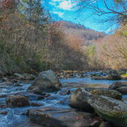
read moreThe southeast corner of Shining Rock Wilderness is filled with rivers, creeks and streams tumbling down from the mountains that rise above 6000 feet in the high country. Included among these waterways is the East Fork of the Pigeon River, otherwise known as Big East Fork. A trail follows the river from Hwy 276 to the confluence with Greasy Cove Prong and beyond. This Big East Fork Trail passes several coves and small waterfalls as it climbs nearly a thousand feet through dark and deep forest. The final push is a climb out of the wilderness...
read moreTransylvania County, North Carolina is known as “Land of Waterfalls” for good reason, as there are 250 unique cascades within a short drive of each other. Upper Whitewater Falls on the Whitewater River south of Sapphire is perhaps the most spectacular. There are two distinct overlooks of the 411 foot plunge taken by the river on its path to Lake Jocassee. Nantahala National Forest has developed a small park with family amenities for those who wish to view this spectacular wall of water. Eight short miles north of Upper Whitewater...
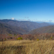
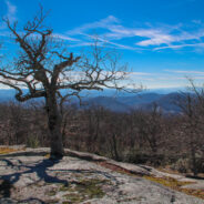
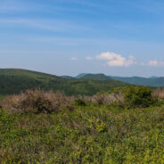
read moreMilepost 420 on the Blue Ridge Parkway is where you will find Black Balsam Road. It’s a short drive to a spruce forest where the Art Loeb Trail crosses the road and heads up onto the balds. This is North Carolina high country. There are several mountains greater than 6000 feet with treeless summits, affording spectacular 360° views of the surrounding Blue Ridge. I love it here. I can’t get enough of the natural beauty to be seen along the Art Loeb Trail as you cross Black Balsam Knob and then Tennent Mountain. The land is rich...
read moreNestled in the woods of Pisgah National Forest in Asheville, the North Carolina Arboretum is a 434 acre public garden located within the Bent Creek Experimental Forest. Set amid rolling hills just off mile 393 of the Blue Ridge Parkway, the Arboretum offers more than ten miles of groomed hiking trails that are suitable for all ages. Home to one of the finest, most unique bonsai collections in the United States, the Arboretum has 65 acres of cultivated gardens that are appropriately seasonal. The Arboretum is an affiliate of the University of...
read moreThis is a two-part hike with a short drive on a forest service road in between. Both the Case Camp Ridge Trail and the North Face Trail start on Forest Road 475B in Pisgah National Forest. The first climbs 1000 feet in 1.7 miles to the Blue Ridge Parkway near Cherry Gap at mile 416. It’s a short walk from the trail to the Cherry Cove Overlook and a close-up view of Looking Glass Rock. Return to the forest road down the same trail and drive another three miles toward Looking Glass. The North Face Trail is a 1.5 mile round trip to the...
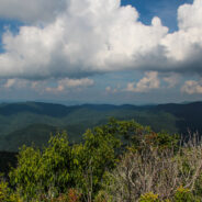
read morePilot Mountain stands 5084 feet above the western edge of Pisgah National Forest, near the Blue Ridge Parkway and Looking Glass Rock. There are three ways to get to its summit, but the one I enjoy most is the section of the Art Loeb Trail from Gloucester Gap along Forest Road 475. It isn’t particularly long, but it is quite strenuous. You will get your exercise climbing Pilot Mountain. The views are stunningly panoramic, making it totally worth the exertion. On an especially clear day you can see all the way to Tennessee and South...
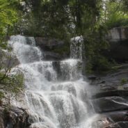
read moreAnother of the myriad of hikes along Forest Road 475 in Pisgah National Forest, this two-parter is near the Fish Hatchery and Pisgah Center for Wildlife Education. First we took a short trip up Forest Road 475B to Slick Rock Falls, then hiked to the base of Looking Glass Rock. The climbers love this area and we encountered some when we reached the base. The main hike was a little further up Forest Road 475 at the Cove Creek Group Camp. The primary feature of this 6-mile loop is Cove Creek Falls, a 50-foot slide waterfall. This is a nice flat...
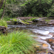
read moreThe Riverside Trail along the South Fork of Mills River in Pisgah National Forest is a great opportunity for boys to be boys, and girls to laugh at them, as the trail fords the river several times. You’ll get to wade in a crisp, cool mountain stream up to your knees as you negotiate the current and the smooth, slippery rocks on the bed. Enjoy the peaceful sounds of the babbling water as you hike alongside this beautiful mountain river that’s full of twists and turns. Start with the two-mile Vineyard Gap Trail up and over Forge...
read moreA spectacular waterfall isn’t the only highlight of the Ramsey Cascades Trail in the Greenbrier area of Great Smoky Mountains National Park. The trail to the cascade gains more than 2,000 feet as it follows rushing rivers and streams filled with moss-covered boulders for its four-mile length. The last couple miles pass through old-growth hardwood forest with giant tulip trees, birch and hemlock. Rhododendron is plentiful as you reach the cascade, the tallest waterfall in the park. Water splashes 100 feet over rock outcroppings and...
read moreIt’s all about the importance of giving back and passing forward… So says the masthead at Summit Stones & Adventure Musings, a fount of wisdom and inspiration that dares to take us to the “wild places,” the summits, canyons and waters of our imagined and realized adventures. True to his aspirations, DSD as he is known, has blessed me with an assortment of Summit Stones to deposit in my favorite secret places… to pass forward. Wilderness trails and ethereal peaks in the Blue Ridge and Smokies will become home...
read moreUsually when you come here you will find a cheerful description of a scenic hike that was fun, and that I recommend for your enjoyment. Instead, I am going to suggest that you stay away from this hike if you value your safety and security. The Brush Creek and Burnett Gap Trails are so terribly maintained as to make them virtually impassible. I’m sure at one time these trails near the French Broad River were quite exhilarating. There are some impressive views of the surrounding mountains from the Brush Creek Ridge. However, this is an...
read more I am Jeff Clark, founder of Internet Brothers, producer of this blog, and passionate about hiking. I live in Western NC near the Blue Ridge and Great Smoky Mountains. Pisgah and Nantahala National Forests are just out my door, so the content will focus on these areas, but let me know what you would like to see on the site.


Copyright © 2011-2023 Internet Brothers. All Rights Reserved. ISSN 2324-6057
Designed by Elegant Themes | Powered by Wordpress | Logo by Design Aspirations