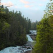
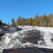
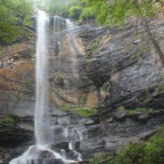
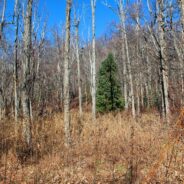
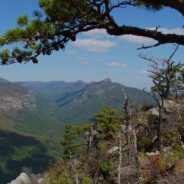
With so much interest in The Hunger Games movie, I thought it was time to head out to DuPont State Forest for a dawn hike to Triple Falls, one of the scenes in the film. Triple Falls is a tiered cascade on the Little River that drops 120 dramatic feet and was also featured in the Last of the Mohicans movie. A photo of Triple Falls was used by the Friends of the Falls conservation group to convince the North Carolina Governor and the Council of State to protect the waterfalls of the Little River from private residential development. After...
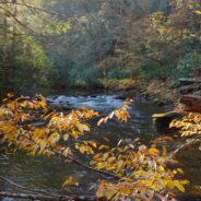
read moreDesignated a National Wild and Scenic River, the Chattooga River’s headwaters are in North Carolina, but it stretches into Georgia and South Carolina as well. In fact, at one point known as Ellicott Rock, it marks the common tri-boundary of all three states. There are more than 50 miles of trails along the Chattooga River but this four-mile stretch just south of Cashiers, NC is a good introduction to get you in the mood for future exploration. This section of the river is known for the steep, remote Chattooga Cliffs that stand guard...
read moreNorth Mills River Recreation Area in Pisgah National Forest, along with its brother at South Mills River, has a rich trail system. It covers the Pisgah Ridge at the Blue Ridge Parkway down to the North Mills River. A combination of trails leading from the Trace Ridge Trailhead at the recreation area go up, over, and around Coffee Pot Mountain on the way up to the parkway. There are plenty of creeks and streams along the way, as well as views of the surrounding Blue Ridge from the top. This hike occurred on Thursday, March 22, 2012 from 9:00am...
read moreThe Mountains to Sea Trail spans the width of North Carolina, running from the Great Smoky Mountains in the west, to the Outer Banks of Coastal Carolina. Much of the trail in the mountainous part of the state is near or parallels the Blue Ridge Parkway. This section of the MST along the parkway has been designated a National Recreation Trail. With elevations well above 5000 feet, there are segments in Haywood County that make nice day hikes in the high country. One of those is Rough Butt Bald at milepost 427. This hike occurred on Thursday,...
read moreSituated in the far northern reaches of the Panthertown Trail System in Nantahala National Forest, Turkey Knob and Blackrock Mountain offer long distance views of the more well known features of Panthertown Valley. From more than 4000 feet elevation, there are splendid views of Little and Big Green Mountains and The Great Wall. The full expanse of Mac’s Gap lays on the floor of the valley between the cliffs of Blackrock and the Greens. Blackrock Trail also connects with Packs Gap, the western entrance to the trail system. This hike...
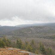
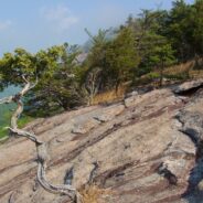
read moreTucked away in the northeastern corner of DuPont State Forest in Western North Carolina, Stone Mountain is the highest point in the state forest at 3620 feet. Appropriately named for the exposed granite slab that traverses its summit, Stone Mountain offers a near 360° view of the surrounding terrain to winter hikers. Wintergreen Falls, though not as spectacular as other waterfalls in DuPont, is nonetheless charming as Grassy Creek tumbles through a deep mixed forest. The name was chosen for the evergreen ground cover known as teaberry...
read moreFalls Creek Falls is a double cascade in the northeast corner of the Mountain Bridge Wilderness in upstate South Carolina that free falls more than a hundred feet. In winter there is a distant view of the top of the falls from 800 feet below at the trailhead on Falls Creek Rd. From the falls, Hospital Rock Trail climbs Standingstone Mountain along Falls Creek for ridge top views of the surrounding wilderness area. This very difficult and strenuous trail continues along the ridge and over several streams to the small cave in Hospital Rock,...
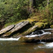
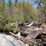
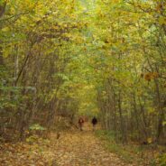
read moreTransylvania County, NC is known as the “Land of Waterfalls,” and for good reason. There are more than 250 waterfalls in the county, with many of the most spectacular falls in the heart of DuPont State Forest. Included among those are Bridal Veil and Grassy Creek Falls, both classic slide waterfalls that carve their way over large granite slabs. DuPont also has several pristine lakes such as Lake Julia and Lake Imaging. All of the features of DuPont State Forest are connected by a mature trail system that is well maintained and...
read moreJones Gap State Park sits on the Blue Ridge Escarpment in northwestern South Carolina very near the state line with its neighbor to the north. Along with Caesars Head State Park, these two share an area known as Mountain Bridge Wilderness. The Jones Gap Trail follows the Saluda River along an old interstate road built by Solomon Jones in the 1850s. In this backcountry the river is quite wild with many waterfalls and rapids that add exciting sights and sounds to a dense hardwood and laurel forest. Near the eastern terminus of Jones Gap Trail...
read moreThompson Creek Trail climbs Thompson Ridge from Forest Road 1206 to a point just below the Pisgah Inn on the Blue Ridge Parkway. To the southwest it overlooks the Cradle of Forestry National Historic Site and the Pink Beds. To the east it crosses from Transylvania County into Henderson County and joins the Pilot Rock Trail along the Slate Rock Ridge for the descent across Pilot Rock, and back to the forest road. Along the way is multi-terrain hiking, varying from a creek-side stroll, to switchbacks on all fours, and rocky scrambles across a...
read moreDuPont State Forest, in western North Carolina between Hendersonville and Brevard, was sold to the state by DuPont Corporation under favorable donation and conservation terms in 1996. Within its boundary are more than 10,000 forested acres and 80 miles of hiking and biking trails. Elevation ranges from 2300′ at Hooker Falls on the Little River to 3600′ on Stone Mountain. The state forest lies on an upland plateau of the Little River Valley with moderate hills and mountains that are topped with large granite domes and slabs. Cedar...
read moreMatthews Creek plunges more than 1,000 feet over Raven Cliff Falls into the gorge it has carved below Raven Cliff Mountain. One of a myriad of landmarks along the Blue Ridge Escarpment in Caesars Head State Park, this gorge offers a very challenging yet rewarding hike. Part of the Mountain Bridge Wilderness Area that also includes Jones Gap State Park, this is the most extensive trail system in South Carolina. More like western North Carolina than the coastal and central regions, the South Carolina Upcountry has similar elevation and forest...
read moreDonated to the Carolina Mountain Land Conservancy by Dr. and Mrs. Thomas Florence in 1996, the Florence Nature Preserve is 600 acres on the slopes of Little Pisgah Mountain. With more than five miles of public hiking trails, much of them along a beautiful mountain stream, the preserve contains old growth forest, views of Hickory Nut Gorge, remnants of old cabins, and several small waterfalls. Seasonally there are a variety of rare plants including yellow lady slipper. CMLC conducts regular ecological monitoring of the preserve, implements...
read moreLooking for a hike that includes streams and rivers, hardwood and conifer forests, plentiful rhododendron, and some climbing for good measure? Then the trails along South Mills River that embark from the Turkeypen Trailhead may be just the ticket. Situated in the southeastern corner of Pisgah National Forest, the Mills River Area is the largest in the Pisgah Ranger District, but also perhaps the least well known. Somewhat remote, this area ranges from 2400 feet elevation at the river level to well over 4000 on the mountaintops. The trails are...
read moreChimney Rock State Park is one of the newest in North Carolina. The state acquired the land from private ownership in 2007, and the Carolina Mountain Land Conservancy continues to obtain additional parcels in the Hickory Nut Gorge to eventually expand the state park. The Rumbling Bald section of the park is separate from the more famous namesake, Chimney Rock. Because this park is new and still in the planning stage, trails are primitive, unnamed, and exciting. Maps are limited. The N.C. Division of Parks and Recreation will eventually...
read morePerhaps the most popular hike in the Pisgah Ranger District of Pisgah National Forest, the Looking Glass Rock Trail is a good 3-mile leg stretcher to the top of the famous pluton. Probably not the most scenic hike is the area, but definitely popular because of ease of access, and a little less difficulty than some of the steeper monoliths. Looking Glass Rock is home to peregrine falcons from spring to fall, and excellent multi-pitch and free-climbing year round. Hiking is also four seasonal, just be sure to watch out for slick ice on the...
read moreMost of the attention in Linville Gorge is focused on the northern features. There are more trails, higher peaks, and family recreation areas. But the south gorge is every bit as compelling and beautiful, with spectacular panoramic views up the gorge and westward to Pisgah National Forest and the Blue Ridge Mountains. Shortoff Mountain is a thousand feet lower than its more famous brethren to the north — Tablerock and Hawksbill — but it also offers unobstructed views of Lake James to the south. Hiking this trail is a sweet...
read moreMontreat is a small community just north of Black Mountain, NC with a world renowned conference center, a college, and best for us, 20 miles of hiking trails that rival those in nearby Pisgah National Forest for quality and scenery. In particular, the Greybeard Trail is an exceptional workout that climbs more than 2300 feet to the summit of Greybeard Mountain on the Blue Ridge Escarpment where there are stunning views of Mt. Mitchell and its other 6000′ brethren. The trails are contained within private conservation land known as Boggs...
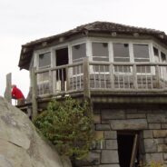
read moreYou don’t have to climb to 6000 feet to get spectacular views of the Smoky Mountains. In fact, Mt. Cammerer has some of the best views in the national park, yet doesn’t even reach 5000 feet. You can see Snowbird Mountain and the Pigeon River Gorge to the east, and Mt. Sterling south, and the full expanse of the national park to the west. Mt. Cammerer was named for Arno B. Cammerer, who was director of the National Park Service from 1933-1940 and was instrumental in the Great Smoky Mountains becoming a national park. The stone and...
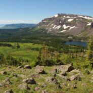
read moreKind of an unusual name for the mountain this trail is named after, but it is at 5,200 feet, so the snow comes earlier in the season, and more frequently than in the valleys below. North of Asheville, NC on the Blue Ridge Parkway, this hike is in the Craggy Gardens area. There are splendid views of the Great Craggy Mountains and the Black Mountains from the three summits that are encountered along the trail. You cross Snowball Mountain, Hawkbill Rock, and Little Snowball Mountain along a trail that is roller coaster in nature, lots of up and...
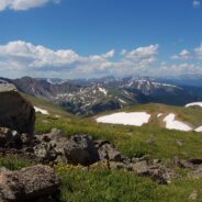
read morePerhaps one of the reasons you head for the Colorado Rockies is the wealth of national parks and monuments. Maybe you enjoy the amazing increase in distance from high altitude golf. If you are a hiker, perhaps you welcome the opportunity to climb one of Colorado’s famous fourteeners. If that’s the case then this hike up Clear Creek County’s 13,234 foot Mt. Sniktau is an excellent warmup. The entire hike occurs above 12,000 feet. You will find out quickly if your lungs and legs are acclimated to the thin and dry air that...
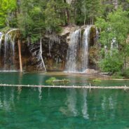
read moreI first visited Hanging Lake in 1982. I heard this summer that the federal government had designated the site a National Natural Landmark, so it piqued my curiosity to take a look again. Glenwood Canyon is a rugged and remarkably scenic place with tall red sandstone cliffs rising 1300 feet on both sides of the Colorado River. The trail up the canyon to the lake follows Dead Horse Creek. Legend has it a gold miner was in the canyon searching for a new stake when he came upon a dead horse at a gulch where a creek fed the Colorado. He climbed...
read moreFlat Laurel Creek is in the area just north of the Pisgah Ridge and in between the Shining Rock and Middle Prong Wildernesses. It drains from Sam Knob and Little Sam Knob and runs to the West Fork of the Pigeon River. The trail that bears its name starts at the headwater and travels 3.7 miles around the west side of Little Sam until it meets Hwy. 215 and joins the Mountains to the Sea Trail. Most of the trail is an old railroad grade that was used in the early to mid 20th century. This hike occurred on Thursday, August 11, 2011 from 9:30am to...
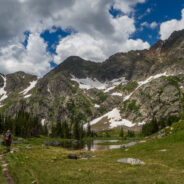
read moreMissouri Lakes Basin in the Holy Cross Wilderness is one of the most beautiful areas in Colorado for hiking and camping that I have experienced. It is an area of lakes and streams filled with trout and large glacial boulders, surrounded by lush forest and tundra, and the gnarly cliffs of the Sawatch Range in the Holy Cross Wilderness. There is some of just about every type of scenery for all hikers to enjoy. The trailhead starts at 10,050 feet and climbs gradually to nearly 12,000 in four miles. This is a popular area as you can imagine, so...
read moreFlat Tops Wilderness is the second largest U.S. Wilderness Area in Colorado. Located near the towns of Yampa and Steamboat Springs, it is 235,214 acres, with 38,870 acres in Routt National Forest and 196,344 acres in White River National Forest. The area is named for a series of flat top mountains that dominate the landscape. This is sub-alpine and alpine terrain with beautiful mountain ponds and lakes, rich evergreen forest, grassy marshes, and craggy tundra. The elevation ranges from 7,600 to 13,000 feet. There are 160 miles of trails in...
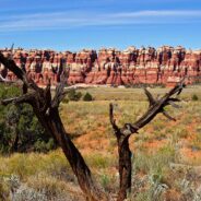
read moreCanyonlands National Park is in the southeastern corner of Utah, near Arches and Dead Horse Point. It is divided into four distinct districts: Island in the Sky, Needles, Maze, and Horseshoe Canyon. The Needles District forms the southeast corner of Canyonlands and was named for the colorful spires of Cedar Mesa Sandstone that dominate the area. The district’s extensive trail system provides many opportunities for long day hikes and overnight trips. Chesler Park is a scenic expanse of desert grasses and shrubs surrounded by colorful sandstone...
read morePerhaps it seems I’ve been spending quite a bit of time hiking in the eastern section of Shining Rock Wilderness in recent months. I can’t help myself. The terrain is wild, the forests ever-changing, the views exhilarating, and the exercise invigorating. The elevation changes dramatically — more than two thousand feet. The air is cool and refreshing even during the summer. It’s enjoyable to follow the wildflower progression from bluets and trillium to catawba rhododendron, to mountain laurel and flame azalea, then...
read moreGorges State Park was developed as a unique partnership of industry, the environmental community and the state of North Carolina. In 1999 more than 10,000 acres of the Jocassee Gorges in Transylvania County were purchased by the state from Duke Energy Corporation. The transaction created a 2,900-acre Gameland managed by the N.C. Wildlife Resources Commission, as well as nearly 7,500 acres that has been designated as Gorges State Park. Because the park is so new, it is still in a planning and development phase. The roads and infrastructure...
read moreThis is an extension of the trail report about the Panthertown Trail System in Nantahala National Forest from a previous post. When we explored Panthertown last November, we knew very little about it and kind of fumbled our way along the myriad of trails. Since, we have studied the trail system map and had a plan that included going to the top of Big Green Mountain, a sight we missed before. This hike occurred on Friday, June 24, 2011 beginning at 10:00AM and ending about 2:45PM. Our plan was to start at the Cold Mountain Gap entrance and...
read more I am Jeff Clark, founder of Internet Brothers, producer of this blog, and passionate about hiking. I live in Western NC near the Blue Ridge and Great Smoky Mountains. Pisgah and Nantahala National Forests are just out my door, so the content will focus on these areas, but let me know what you would like to see on the site.


Copyright © 2011-2023 Internet Brothers. All Rights Reserved. ISSN 2324-6057
Designed by Elegant Themes | Powered by Wordpress | Logo by Design Aspirations