
Between mileposts 423 and 424 on the Blue Ridge Parkway, Scenic Hwy 215 crosses at Beech Gap. If you head about 1/4 mile north on 215, the famous Mountains to Sea Trail crosses from the Black Balsam area into Middle Prong Wilderness. The MtS winds through an ever-changing forest that runs the gamut of evergreens found in the high country of Western North Carolina. Past waterfalls and streams, through thickets and meadows, surrounded by 6000 foot tall mountain peaks, with the always present aroma of pine and spruce and fir, this stretch of the MtS to the Green Mountain Trail is a hiker’s delight. Climb a short way up Fork Ridge to a lonely outcrop on the eastern flank to gaze far and wide into the vast expanse of Shining Rock Wilderness. It doesn’t get much better. This hike occurred on Tuesday, December 11, 2012 from 10:00am to 2:05pm. Our plan was to take the Mountains to Sea Trail from Hwy 215 to its junction with Green Mountain Trail. We would then climb Fork Ridge near Green Knob to that lonely outcrop and return.
Hike Length: 7.3 miles Hike Duration: 4 hours Blaze: None, wilderness
Hike Rating: Moderate Hike Configuration: Out and back.
Elevation Gain: 850 feet Trail Condition: Very good. Watch for roots.
Starting Point: Where the Mountains to Sea Trail crosses Hwy 215.
Trail Traffic: We did not encounter any other hikers, but heard plenty of bear dogs howling in the distance.
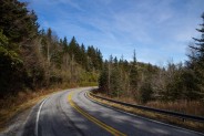
How to Get There: From Brevard, NC take Hwy. 276 into Pisgah National Forest, and all the way to the top at Wagon Road Gap where it meets the Blue Ridge Parkway at milepost 412. Turn south on the parkway toward Cherokee and go 11.3 miles to Hwy. 215. Turn right (north) and look for parking on the left about 1/4 mile down the road. The trailhead is on the left another 200 yards beyond the parking.
Are you perhaps looking for a day hike that will take you through a wide and diverse array of forests, alongside babbling mountain streams and waterfalls, and culminates with exceptional long distance vistas above 6000 feet? Sounds really enticing doesn’t it?
Well, strap on your hiking boots and backpack because I have one to tell you about. Up in the high country off the Blue Ridge Parkway in Pisgah National Forest are two designated wilderness areas with incredible hiking offerings. Shining Rock Wilderness is, no doubt, the more well known of the two, and yes it is fabulous. But if you’re interested in lesser traversed trails that are equally enthralling, Middle Prong Wilderness fills the bill.
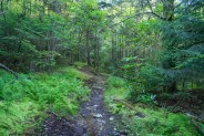
These two wilderness areas abut each other, separated by Scenic Hwy 215, otherwise known as Lake Logan Road. Between mileposts 423 and 424 on the Blue Ridge Parkway, Hwy 215 crosses. Just a quarter mile north on 215 the Mountains to Sea Trail crosses 215 from the Black Balsams into Middle Prong Wilderness, named for the middle prong of the Pigeon River. Park on 215 and look for the unmarked, but obvious trailhead on the left side of the highway. It heads upward to the northwest.
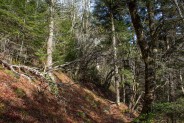
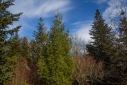
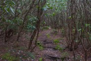
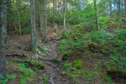
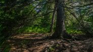
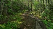
The well-worn trail winds through a mixed forest of high country birch and beech and conifers, and the omnipresent WNC rhododendron. Don’t look for blaze markings in the wilderness as there aren’t any, but the trail is plenty easy to follow.
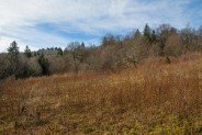
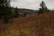
You come to a meadow surrounded by gorgeous black balsam spruce with two campsites, one at trail level, and another more secluded at the plateau of a small rise. These sites would be a nice pair for a double camping date. The Mountains to Sea Trail (MtS) continues through the meadow and eventually makes a decidedly southern turn.
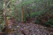
You’ll hear the soothing sounds of the West Fork headwaters, a gentle breeze, and for us on this mid-December day, the unmistakable bay of bear dogs. They were miles away, but sound reverberates off the granite in the high country hollows. You will cross the creek twice, not difficult, except perhaps in spring when the water level may be up from snowmelt.
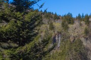
The trail seems pretty level, but is actually climbing at a very gradual pace, resulting in the appearance of the high granite cliffs and ridges far in the distance on either side of the trail. With a healthy rain the previous day, my companion and I were treated to a sight I hadn’t observed on two previous trips to this track. To our right, westerly, was a beautiful waterfall about 1/4 mile away. It was plunging about 70-80 feet over a sheer granite ledge. My guess is this is one of those surprise waterfalls that only appears on rare, wet occasions. It was a real treat.
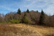
As you proceed the forest becomes less dense with more of a low-lying scrub and “christmas tree” type appearance. The immature white pine, spruce and fir not only set a seasonal mood, but smell delightful. Catching this area after a recent snowfall would be a special joy. The trail again switches back to a northerly direction as you parallel the eastern face of 6110′ Mount Hardy on your left.
Continuing the push north, you’ll pass a small clearing that opens up a view to the northeast of the Black Balsam area and your first peak at Black Balsam Knob itself as well as Little Sam Knob. Those large mountains will be quite commanding at the final destination.
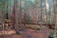
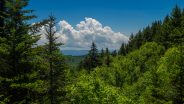
I love the next section of trail because it is a botanists delight. The sudden and distinct changes in the forest diversity are inspiring, and actually kind of eerie. Start with a good mix of beech, birch, spruce and fir, then suddenly enter an extremely dense, dark forest of white pine and black balsam. Next to no light reaches the ground which is soft and cushy from centuries of fallen needles. As you exit this aphotic alpine wood, you next enter an even more compact rhododendron grove. Don’t get off-trail here as you would likely be lost for days. The trail is clear, but either side is a convoluted jungle of twisted rhodo trunks. I thought of the trail builders when going through here.
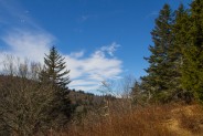
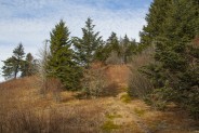
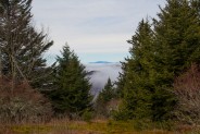
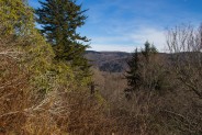
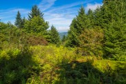
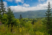
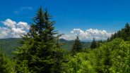
On the other side, the trail begins a steeper climb then pops into another meadow with exceptional panoramic views to the west of the heart of Middle Prong Wilderness. We were surrounded by low-level valley fog that I always find fascinating as the higher peaks poke their tops through the murk. To me, it seems to give a majesty to the high country… living above the clouds.
We could really hear the howling of the hunting dogs now as we made the short but steep climb up to Fork Ridge. This is the hardest stretch of the hike, but still quite moderate, and it only lasts for a hundred yards or so. You’ll head back into the forest, dark again, mostly evergreen now with occasional glimpses of the surrounding wilderness on each side of the ridge. Shining Rock is to your right and Middle Prong to your left.
Once you top Fork Ridge, look closely for the trail junction with the Green Mountain Trail. It isn’t marked, but it comes in from your right and proceeds due north. If you miss it, the MtS continues on to Buckeye Gap. So if you reach the Buckeye Gap Trail, know that you have missed the Green Mountain Trail and gone too far. For this hike, you want to turn right on the Green Mountain Trail. Remember that this is wilderness, so there are no trail markers.
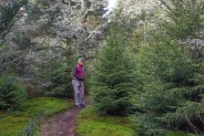
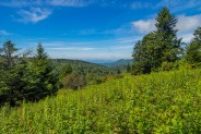
The ridge on the Green Mountain Trail is covered with “christmas tree” like spruce, tall grasses and fields of lichens and ground cedar — simply another gorgeous display of the flora presented in the high country. I love it! You will come to a campsite on your left that is surrounded by 12-foot spruce that make an excellent wind break. I’ve stopped here for a snack before, but today our lunch break would be on the outcrop overlooking the balds of Black Balsam.
It’s no more than half a mile past the campsite. The trail will dip and rise on Fork Ridge a couple times, but keep your eyes peeled to the right for a non-maintained spur trail heading to the east. It isn’t easy to spot, but when you see it, you’ll know it. It’s no more than 30 yards off trail to the outcrop, a perfect place for 3-4 people to take off their packs, sit on the terraced rock formation, and gaze for miles into the WNC high country wilderness. For the two of us, it was perfect.
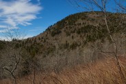
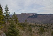
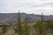
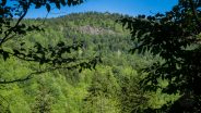
The outcrop has a 180° perspective. To the northeast are the trio of grand mountains that make up Black Balsam. From left to right are the double-peaked 6050′ Sam Knob, then Sam’s junior, but no less impressive brother, Little Sam, and beyond them is the massive summit of 6214′ Black Balsam Knob. Far in the distance is Shining Rock Wilderness.
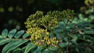
Directly east is Flat Laurel Creek and Wildcat Falls, with the 6000′ Chestnut and Silvermine Balds behind. Interestingly, Chestnut Bald no longer is. There is a very healthy stand of black balsam spruce on its summit.
Turning southeast you’ll see the Devil’s Courthouse, a mammoth outcropping right on the Blue Ridge Parkway that surveys the Blue Ridge as far as the eye can see. You can follow the Parkway as it carves its way along the crest of Pisgah Ridge, and the Hwy 215 ribbon twisting through Beech Gap.
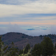
It was a gorgeous day, near 50° in the sun, perfect hiking weather, with layer upon layer of clouds interspersed with sky. See the picture at the top of this post for an example (click for a larger image). To the south, and into the sun, those clouds were doing a crazy dance with the mountain summits that really caught our attention as we dined on fine soup, apricots and peanut butter. Only the best for the Meanderthals.
After lunch we pondered continuing on to Green Knob, but with the way that crazy sky looked, we thought perhaps it was best to turn around and head back. It’s no fun being caught in a storm at 5800′. Between wind, rain, hail and snow it can ruin your day in just a matter of minutes. Besides, we could save Green Knob for another day coming up the Green Mountain Trail from the Sunburst end.
It didn’t take long to realize our decision to head back was sound. As soon as we got out of the sun that was warming us on the outcrop, the temp was several degrees cooler in the forest. The breeze began to pick up as well and we quickly put back on the layers and headgear we had shed while enjoying our break. Each time we passed a clearing I could tell the clouds were getting just a little bit closer.
When we got back down off Fork Ridge and onto the flats of the MtS again, the breeze was sucking the wisps of fog into the gaps and hollows — quite a fascinating and mysterious sight. I’m accustomed to ground-level fog early in the morning. It’s always an alluring effect at mid-day.
We passed back through each of the disparate forests, back by Mount Hardy and the waterfall. By the time we got to the meadow with the dual campsites, it was sunny again. So no need for concern about bad weather, thank goodness.
It’s always a good idea to be totally aware of your surroundings when hiking in the high country, and to be prepared. I always take a rain jacket, no matter what. It’s also a good idea to have extra socks, gloves, hats and layers in your pack just in case. Particularly when hiking in December, or even later in winter, the temperature can change 20-30° very quickly. Sudden wind can be relentless, and if you get caught in a hail storm, it is life threatening. Just remember where you are. This is wilderness, not some friendly neighborhood civic park.
When we got back to the car, we put away our hiking gear and pulled out our conscientious “Leave No Trace” gear. When hiking in this vicinity once before, my friend and I had noticed a campsite near the road that was completely and totally littered. This site was so full of trash that it frankly offended us when we came upon it that day. We weren’t prepared back then, but on this day we were. By the time we were through we had filled two large trash bags with bottles and cans, milk jugs and aluminum foil — junk that did not belong in the wilderness.
Best HikeTo summarize, the Mountains to Sea and Green Mountain Trails in Middle Prong Wilderness should always be on your list of weather and seasonal appropriate hikes in the Western North Carolina high country. If you love forested hikes, you will see a wide variety. If you like the high vistas, the outcrop on Fork Ridge offers views that will inspire you. For the water enthusiasts, part of the trail even follows a babbling brook with the chance to see a surprise waterfall. I highly recommend it. For us, it was a great day, and I would label this one a best hike.


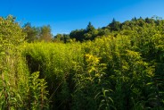
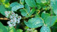
Updated August 26, 2014: Time for another visit to this magnificent region of Middle Prong Wilderness. Realizing we had never been there in summer, we wanted to check out the trail condition. There were a few spots in the meadows where the late summer foliage like the goldenrod were hanging over the trail, but most of it was still easily navigable. There was a slight hint of autumn in the air and on the trees, making it a most delightful day.
We found a line of puffy white clouds wafting up the valley formed by Hwy 215 between Fork Ridge and the Balsams that prevented a clear view of the Sams, but it was still delightful at the rock outcropping on Green Knob. I know I will continue to return for this hike time and time again. It is simply one of the best in the WNC high country.

Update July 2, 2016: Here are a few more photos from a visit in early summer. Compare for seasonal differences.


The following are paid links. As an Amazon Associate I earn from qualifying purchases.
 I am Jeff Clark, founder of Internet Brothers, producer of this blog, and passionate about hiking. I live in Western NC near the Blue Ridge and Great Smoky Mountains. Pisgah and Nantahala National Forests are just out my door, so the content will focus on these areas, but let me know what you would like to see on the site.


Copyright © 2011-2023 Internet Brothers. All Rights Reserved. ISSN 2324-6057
Designed by Elegant Themes | Powered by Wordpress | Logo by Design Aspirations


Love this hike! Feel like it’s a “best kept secret” and a good place to escape the “crowds” that can gather in Shining Rock. The trip to Green Knob is well worth the extra effort and mileage…but, you’re right, not good in a storm.
Jeff, did this hike 3/4/13, and enjoyed all of the trail as far as the great outcrop where you (and we) had lunch. The views from there, and from the grassy meadow on the west side, were super! Loved seeing my beloved Shining Rock/Black Balsam/Sam Knob area from a new perspective. Much of the trail had up to six inches of snow. Also found the spur that heads toward Mount Hardy, and plan to go there soon. Your trail descriptions are very helpful.
The Middle Prong is on my list for next weekend. I’ve spent better than 40 years in Shining Rock, Graveyards, and Flat Laurel area, but never made it to MP. Looking forward to it.