
Crowning the Mount Sterling Ridge, 5842 foot Mount Sterling is another of the tall peaks that give the Great Smoky Mountains their character. Located in the far eastern area of the national park in North Carolina, the 7-mile Mount Sterling Ridge rims the scenic Cataloochee Valley to the southeast. There are trails to the summit of Mount Sterling from every direction, but the shortest and steepest begins at Mt. Sterling Gap on the east side. This six mile round trip climbs nearly 2000 feet through the type of dense mixed forest that Great Smoky Mountains National Park is known for. Awaiting you at the summit is a 60′ fire tower that enables panoramic views of other great mountains and valleys in the Smokies. This hike occurred on Wednesday, August 22, 2012 from 9:00am to 12:40pm. My plan was to tackle Mt. Sterling from the east at Mt. Sterling Gap. The Mt. Sterling Trail meets the Mt. Sterling Ridge Trail one half mile from the summit. I would return the same way, then explore some of Cataloochee on the Mt. Sterling Road.
Hike Length: 6 miles Hike Duration: 3.75 hours Blaze: None needed
Hike Rating: Difficult, strenuous climb Hike Configuration: Up and back
Elevation Gain: 2,022 feet Elevation Change: 1,945 feet
Trail Condition: Mostly very good. Loose rocks slow your progress.
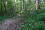
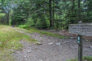
Starting Point: Mt. Sterling Gap on Mt. Sterling Road.
Trail Traffic: I did not see another person on the trail or at the summit.
How to Get There: From I-40, take the Waterville Road Exit (#451). Turn left after crossing the Pigeon River and proceed 2.3 miles to the intersection with Mt. Sterling Road. Even though a sign for the national park is straight ahead, turn left onto Mt. Sterling Road. After 1/2 mile it becomes a long gravel road that twists and turns and climbs southward. The trailhead for the Mt. Sterling Trail is located at Mt. Sterling Gap, roughly 6.8 miles from the intersection.
When you get to the Mt. Sterling Road intersection you may be tempted to go straight ahead into the Big Creek area of Great Smoky Mountains National Park. There are several great trails to hike in there. But, if you want to climb Mt. Sterling you need to turn left. It is then 6.8 miles to the trailhead at Mt. Sterling Gap. All but the first half mile is gravel forest road. Note that Mt. Sterling Road is frequently closed by snow in winter, so it is advisable to call ahead.
There’s enough room for 4-5 cars at Mt. Sterling Gap, so don’t worry about finding a place to park. There were a couple National Park Service vehicles there when I arrived at 9AM, but I didn’t see a single person out on the trail. Mt. Sterling Road continues on southward to the Cataloochee Valley and campground. When I finished hiking I went down there a way to take a look. More about that later.
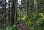
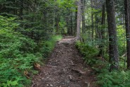
The Mt. Sterling Trail is wide and easily identifiable. At least the first mile or so was probably a road at one time. There are no blaze markers, but none are needed. The trail is easy to follow. You better get used to climbing because that’s what you’ll do all the way to Mt. Sterling Ridge. With the exception of a short couple hundred yards of flat terrain at the junction with Long Bunk Trail, you will climb at a moderately difficult grade of 700 feet per mile throughout.
The lower 1/2 mile goes through an area of old growth hardwoods that looked to include hickory and poplar. I’m far from a tree expert. At the half mile mark is that Long Bunk Trail junction. It connects with the Little Cataloochee Trail, known for a number of historic buildings and for elk sightings. But that’s a hike for another day. Mt. Sterling Trail resumes its climb soon after the junction.
The next two miles is a tiring, relentlessly uphill trudge through a series of three very long switchbacks. I’ve climbed another of the Smokies famous peaks, Mt. LeConte, a number of times. Even though Alum Cave Trail at LeConte gains more elevation, I found the Mt. Sterling Trail to be more difficult because the gain/mile is greater. I was alone on this hike because my usual companions were still out of town, so I didn’t feel bad stopping frequently to suck air for 30 seconds or so.
The higher I got, the rockier the trail got. The Mt. Sterling Trail is shared with equestrians, so I’m not sure if the rock was moved here to fortify the trail bed, or if this is natural breakdown. The stones start out as pebbles, then become fist size about half way up, finally becoming more like softballs and volleyballs near the top. There was one particular site that caught my attention, a tree hugging the side of the trail with a number or rocks wedged within the root system. More of the rocks were spilling onto the trail in a pattern that looked as if the tree has been ejecting them over time.
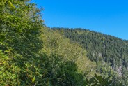
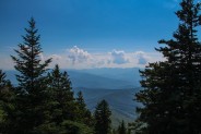
At the 2nd switchback is the first view of the outside world. There’s just enough of a clearing through the woods to be able to see the northern end of Mt. Sterling Ridge. This trail probably offers more to see in winter when the trees are leafless, but mid-summer hiking is not conducive to long distance viewing. The next stretch of the climb, between the 2nd and 3rd switchbacks, was the most interesting in terms of foliage and views.
The forest itself changes considerably, switching from predominantly hardwoods at the lower level, to a timberland of spruce and fir up high. There appears to be more water at the higher elevation because the ground cover is richer, more fertile. The ferns and moss are thicker and greener. I found it to be a verdant delight. There are also a number of metamorphic sandstone outcroppings along the trail. The breakdown is almost shale-like.
And finally, there are a few views to the south of the Cataloochee Valley. One is man made. Believe it or not, they ran power to the summit of Mt. Sterling, so there is a transmission line cut on the east side of the Mt. Sterling Ridge. It opens a window for observing Cataloochee Ridge on the other side of the valley. It was quite a surprise when I walked upon a 15 foot power pole along the side of the trail in the middle of the forest.
The rudbeckia coneflowers were blooming along the trail. I was treated to one especially scenic grouping with another narrow view of Cataloochee Valley in the background. There was even the occasional swatch of Spanish moss hanging down from the spruce branches. It seemed every 100 yards or so was another sensory memory. Then, there’s the final switchback, and the remaining quarter mile to Mt. Sterling Ridge.
To go to the summit, you want to turn right on the Mt. Sterling Ridge Trail. This is also called the Benton MacKaye Trail, named for one of the original founders of the Appalachian Trail. After the arduous climb, the ridge trail is quite a relief. It’s a relatively flat, but muddy last half mile to the summit through a deep spruce forest. You’re almost there when you reach the hitching posts for the horses. Take a little turn around the corner and there’s the 60 foot fire tower to your right.
Mt. Sterling was where the park service first documented the arrival of the woolly adelgid in 1963. Half a century later, this non-native insect has destroyed an estimated 95 percent of the park’s Fraser firs and has now infested the hemlocks as well, leaving dead groves called “ghost forests” at the higher elevations.
Built by the Civilian Conservation Corps in 1935, the Mt. Sterling fire tower is one of four still remaining in the national park. It has the highest elevation of any true fire tower left in the eastern U.S. Until the 1960s, when aerial surveillance made most fire towers obsolete, this tower was manned five months out of the year by crews that worked in rotating shifts and lived in a nearby cabin. At the base of the tower is a backcountry campsite.
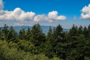
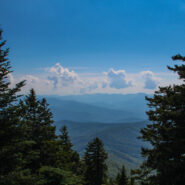
I’ve wrestled with acrophobia all my life. The nearly 80 year old tower, while not rickety, did not leave me with a comfortably safe feeling. Despite this, I gave it a go, figuring if I could get at least half way up I could see most of the surrounding countryside. The wooden plank steps are extremely steep, almost ladderesque, reaching increasingly small platforms every 10 feet. The third platform, at 30′, faced primarily southward toward Cataloochee Valley and east to the Blue Ridge in North Carolina. I snapped a few pictures then summoned enough courage to go up one more level.
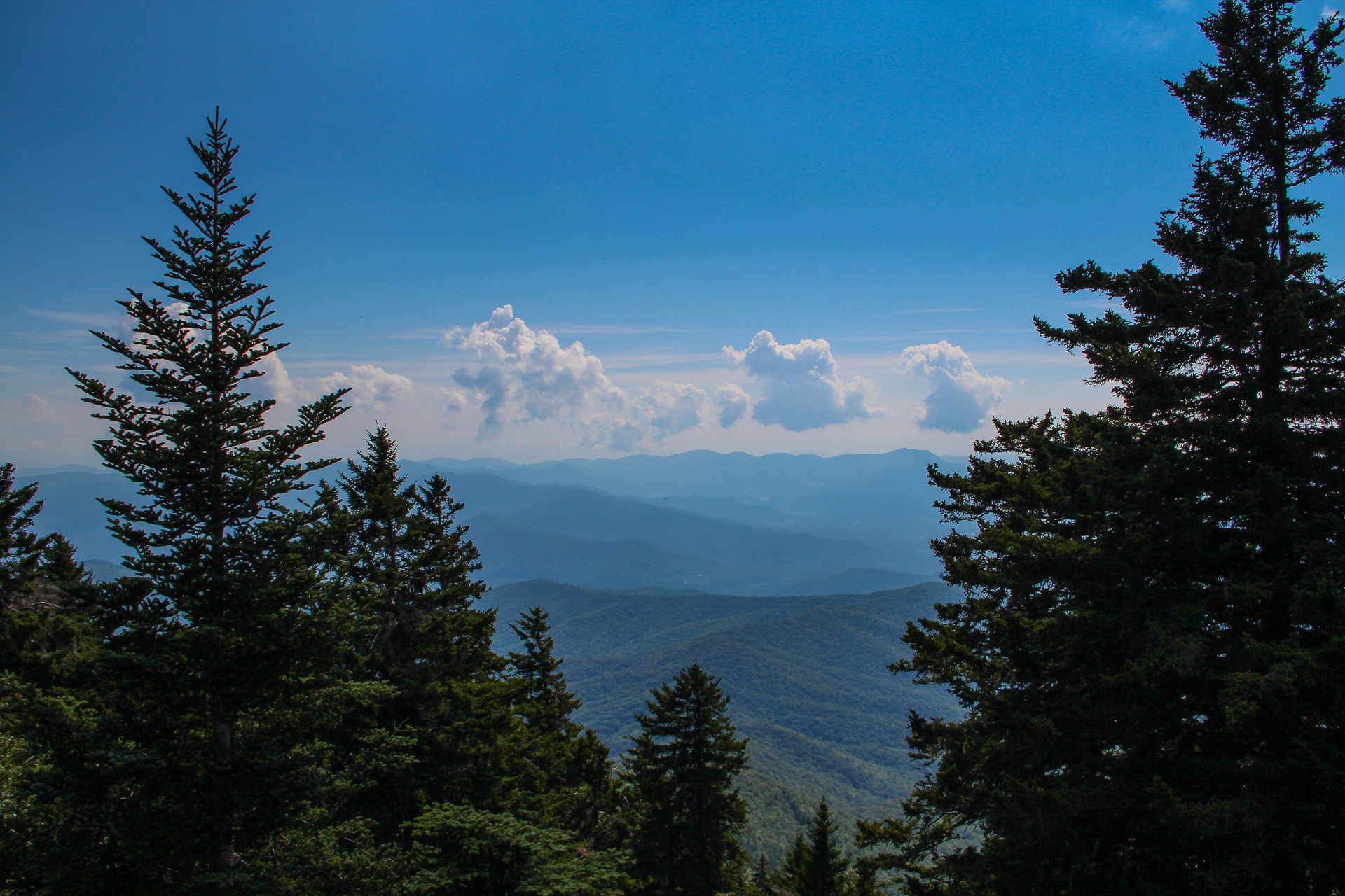
About half way up the next flight of stairs I began to feel that very familiar light headed queasiness, but managed to keep going to the 4th platform. It couldn’t have been much more than about five square feet, just barely large enough to stand on. I took several deep breaths and convinced myself I could hang for a few minutes. This platform looks mostly northward toward Mt. Cammerer and Mt. Guyot, and to the west where Balsam Mountain stretches on the horizon.
If you are interested, the park service still leaves the trap door to the tower open so you can go all the way to the top. I was doing well to go as far as I did, so I didn’t press my luck. Believe me when I tell you that I took my time going back down, but obviously I’m still here to relay my experiences.
Before heading back down the trail, I pulled up a log at the campsite for a sandwich and an apple. I watched a number of swallowtail butterflies fluttering by on the gentle breeze. I noticed one of those pulley contraptions that are used to raise your food into the trees overnight for bear prevention. At the northeastern end of the summit the Benton MacKaye Trail continues toward Big Creek as the Baxter Creek Trail. Perhaps some day I will return to Mt. Sterling that way.
To give you an idea of the exertion required to climb the Mt. Sterling Trail, it took me two hours to get up, but only an hour and 15 to get back down. As I passed each landmark that I remembered, it was surprising how quickly I got there. The breeze came up as I was walking down and was a perfect comfort. I’ve always liked the sound of the wind rustling the trees. It’s especially pleasant in our national forests and parks. The wild places are national treasures that have been passed along to us by those foresighted thinkers who protected these lands for the future. It is our job to take care of them the best we can so the many generations that follow can enjoy them as much as us. Just being there helps me remember.
The tough part about the descent is all the rocks on the trail. They tend to want to move and shift so I had to step carefully. Fortunately it doesn’t last. The last mile is quite easy as it’s mostly a dirt trail bed.
When I reached the car it was still relatively early, so I continued south on Mt. Sterling Road to explore Cataloochee Creek. After about three miles I passed the northern trailhead for Little Cataloochee Creek. Another mile after that I reached a bridge over Little Cataloochee where it met Cataloochee Creek.
Around a few more bends was the water gaging station and a larger bridge over Cataloochee Creek. They use the stream flow and other hydrologic data collected here to make possible the assessment of natural hydrologic changes and trends that are not significantly influenced by man. Nearly 50 square miles are drained by the Cataloochee Creek basin.
Looking around at the surrounding terrain and forest it was apparent that I wasn’t getting near any grassy meadow areas that might be prime for elk viewing, so I decided to turn around and head back. During the 11 miles back on Mt. Sterling Road I encountered three other vehicles, the first I had seen of other people all day.
That surprised me. The other mountain peaks that I’ve visited in Great Smoky Mountains National Park are apparently more popular. To me though, Mt. Sterling doesn’t play 2nd fiddle to Mt. LeConte or Mt. Cammerer. The views are just as sterling, so to speak. I really enjoyed the trails and the vistas and would recommend the hike to friends, and to you. Be sure to take plenty of water and food. It isn’t long but it is strenuous. Just stay nourished and hydrated and you’ll be fine.


The following are paid links. As an Amazon Associate I earn from qualifying purchases.
 I am Jeff Clark, founder of Internet Brothers, producer of this blog, and passionate about hiking. I live in Western NC near the Blue Ridge and Great Smoky Mountains. Pisgah and Nantahala National Forests are just out my door, so the content will focus on these areas, but let me know what you would like to see on the site.


Copyright © 2011-2023 Internet Brothers. All Rights Reserved. ISSN 2324-6057
Designed by Elegant Themes | Powered by Wordpress | Logo by Design Aspirations

