A new trail for hiking and mountain biking just opened in Brevard, NC’s Bracken Mountain Preserve. The approximately 1.5 mile trail, called the Pinnacle Trail, offers a steep climb with 500 feet of elevation gain and creates a new loop. It brings the trail system in Bracken Mountain Preserve to nearly nine miles. These trails create a direct connection between Brevard and Pisgah National Forest.
Volunteers were instrumental in the construction of these new trails. Professional trail builders with Long Cane Trails collaborated with two service groups organized by Conserving Carolina—Friends of Brevard Area Trails and Summer of Service. These trail crews hiked for miles, carrying heavy tools, just to reach the trail building sites.
Volunteers with Friends of Brevard Area Trails included many community members who helped build the original Bracken Mountain trails. Summer of Service, an AmeriCorps program for local 17-to-20-year-olds, completed the work needed to open the new trail to the public. In all, volunteers and Summer of Service members contributed 239 hours to create the Pinnacle Trail.
Todd Branham, the owner of Long Cane Trails, says, “The Bracken trail project has been a great example of how trails connect communities. With the efforts of the community we were able to deliver the trail at 50% less than usually cost to fully construct a trail. Hikers, bikers as well as outdoor enthusiasts joined in the efforts to make the Bracken Trail come to fruition. This project is a model to use as an example of how any community can get more trails on the ground while engaging the members of their community.”
The giant trees of Sequoia National Park will fill you with awe — and give you a crick in your neck from staring up at them. The wild backcountry of Kings Canyon National Park will bring you over-the-top adventure — and muscle cramps from walking too far with a 35-pound pack on your back.
Shoulder-season visitors (September-November) avoid the hustle and bustle of peak times. Traffic lessens, autumn leaves appear and it becomes easy to find a parking spot. The campgrounds that were always full during the summer now have vacancies.
The weather also cools off, a big plus. Many days top 100 degrees during the summer. Weather like that is brutal if you’re hiking — or even just taking a quarter-mile nature walk with the kids. Skip the sizzling July and August weather and visit in October when average highs are in the 60s.
Sequoia has the largest trees on the planet and Mt. Whitney, the highest point in the Lower 48. Kings Canyon is by some measures considered the deepest canyon in the country. It’s a place that can make visitors feel very small. It also can bring a sense of tranquility to complicated lives.
The adjacent parks, which are administered together, offer beautiful rivers and waterfalls, lush valleys, vast caverns, snow-capped peaks and terrain ranging from 1,300 to 14,500 feet.
When it comes to outdoor adventure, Oahu packs a punch. Within its 597 square miles, visitors to the island can find stunning beaches to unwind on, delicious local foods to enjoy, and miles upon miles of hiking trails to explore.
According to Best of Oahu, there are close to 50 different hiking trails to choose from around the island. From beginning to expert, the island’s hiking trails have it all. The one thing they all have in common is the fact that they each end with a spectacular view of Oahu and the Pacific Ocean below.
Located on the eastern side of Waikiki’s coastline sits the Diamond Head State Monument, one of the island’s most recognizable landmarks. The monument, which takes up a whopping 475 acres of land, has plenty for visitors to see and do, including hike to the summit. The summit trail, first built in 1908, is just .8 miles long. Though short, it’s still difficult — on that quick walk you’ll gain 560 feet of elevation — but the view is well worth the huffing and puffing.
The hike to Waimea Falls is more of a leisurely stroll than a workout, but it’s stunning just the same. Upon entering the park guests can take a paved road on a quick one-mile walk through a gorgeous botanical garden. At the end, visitors are rewarded with a glimmering lake and waterfall. Those adventurous enough can even hop in for a quick swim before hiking back out again.
Now that fall is just around the corner, you may be thinking about taking a hike. September offers plenty of opportunities, with Public Lands Day hikes at all state parks, plus plenty of other chances to get out and enjoy beautiful Middle Tennessee on foot.
All 56 Tennessee state parks have free, ranger-led hikes or volunteer park and trail cleanup programs on National Public Lands Day, Sept. 28, 2019.
Rugby State Natural Area has a free guided hike starting at 10 a.m. Eastern time from the Historic Rugby Visitor Centre Porch, 1331 Rugby Parkway in Rugby. This is a 3-4 mile, moderate but family-friendly hike. Dogs on a leash are welcome.
At Harpeth River State Park, Ranger Bill Morton will combine a hike through the historic Narrows of the Harpeth with some trail cleanup. “We will pick up trash, trim branches and learn the history of the area along the way,” Morton said.
And if you want an urban hike, head for Bicentennial Capitol Mall State Park, where you can “immerse yourself in Nashville history and culture” with a hike through downtown.
Walk at your own pace on the Greenway at Butler Field along the Little Harpeth River to witness fall wildflowers in bloom and lots of butterflies. Warner Parks also has brochure-led hikes for the Hungry Hawk Trail and the Nature Loop, too.
North Carolina House Rep. Chuck McGrady, Conserving Carolina, and Friends of the Ecusta Trail are pleased to announce that Conserving Carolina was awarded a $6.4 million purchase grant for the rail corridor known as the TR Line or Proposed Ecusta Trail. “This is a very big next step for the Ecusta Trail”, said McGrady. “There is still a lot of work to be done and a lot of processes to work through that will take time, but this is a large step forward.”
The proposed greenway will run from Kanuga Road in Hendersonville to the old Ecusta Plant property in Brevard, between Ecusta Road and Old Hendersonville Highway. This rail line has been inactive since the Ecusta cigarette paper plant closed its doors in 2002.
Friends of The Ecusta Trail was founded in 2009 as a volunteer organization to study, educate and advocate for the acquisition and development of the proposed Ecusta Trail. Their efforts over the years have included garnering endorsements for the trail by the Cities of Brevard and Hendersonville, the Town of Laurel Park and the Henderson County Commissioners in addition to nearly 50 other non-profits and organizations throughout western North Carolina.
Representatives of Friends of the Ecusta Trail asked Conserving Carolina to take the lead in grant application process. Conserving Carolina submitted the grant application to NCDOT in July, 2019. The grant was approved this month.
Nestled in the heart of the Daniel Boone National Forest, the Red River Gorge attracts thousands of outdoor recreation enthusiasts year round. Rock climbers, hikers, canoeists and campers are among those who come to enjoy and explore this rugged landscape, often referred to as simply “The Red” by its most frequent visitors.
Across its steep terrain, miles of towering cliffs line the upper slopes of forested ridges. Along the cliffs, unique rock formations randomly appear as huge monuments withstanding the test of time. Artfully sculpted by wind and water over millions of years, more than 100 sandstone arches and other natural rock features are formed as part of this geographic masterpiece. Chimney Top Rock, Half Moon, and Sky Bridge are just a few of Mother Nature’s most impressive creations that you’ll find here.
In the valleys below, boulder-strewn creeks and streams flow through densely shaded coves of hemlock and rhododendron, eventually reaching their destiny as part of the scenic Red River. These cool, clear waters support a diverse array of aquatic species, as well as sport fish for anglers. In its swift upper reaches, paddlers find challenging stretches of Class I to III whitewater rapids to test their skill.
The scenery alone is enough reason to visit this remote and remarkable place, but a spellbinding sense of adventure seems to be what draws people back again and again. Their secluded journey takes them to a place that feels untamed and untouched by modern progression.
The Appalachians are full of many natural wonders, and with a long holiday weekend ahead of us (and great weather predicted), it is a good time to get outdoors and reconnect with nature. Hiking is one of the ways many of us do that. As you hit the trails this fall, remember to keep safety in the forefront of your mind.
Often, hiking is a more strenuous activity than walking. You should consult with your physician before beginning any hiking or exercise program. If you are a beginner hiker, start slow and choose paths with shorter distances and gradually work your way up to more difficult ones. Many times, especially at State Parks, hikes will be rated easy, moderate or difficult. Pay attention to the hike rating before starting down the path. Wear comfortable shoes with good soles.
If you carry a backpack, remember it can add 10 to 15 pounds to your frame. The added weight will require you to exert more energy, so you may want to hike a shorter distance until you are used to carrying the extra weight.
Steer clear of noxious plants like poison ivy, poison oak and poison sumac. Avoid walking in high grass or weeds, as these areas commonly have ticks and chiggers. Always check yourself for ticks during and after returning from a hike. Wear light-colored clothing, so ticks are easy to spot. Be on the lookout for mosquitoes, particularly if you are hiking in areas with a lot of stagnant, standing water.
Also, it’s always a good idea to carry a first-aid kit with you for emergencies. If you are going on a short hike, store the kit in your car. Take it with you on longer hikes.
Tips from the 4-H Cooperative Extension Service
When preparing to go on a hike, there are a lot of things to think about. You want to make sure you are prepared with supplies and that you know the area well enough. You also have to consider how difficult the hike will be and how long it will take. While these are all important things to think about, it’s also important to keep in mind how you act when on the trail. There are some things that hikers do that are rude as well as harmful to the environment.
Overall, be considerate and remember to read any signs that are posted and follow the rules. People who ignore signs can get themselves into a lot of trouble.
They could find themselves in a dangerous area or too close to wild animals. Not reading and listening to the instructions on the signs while on a hike can lead to a lot of trouble for the park rangers (and you).
When on a hike, it’s important to respect and understand the animals around you. Remember that this is their home, and you are visiting. Some wildlife, even those that you might not think are dangerous, can hurt you if they feel threatened.
These are things that park rangers can’t stand and wish that visitors would avoid doing…
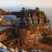
Stepping out above the treeline to the eagle’s nest lookout behind Pravčická brána, the sweeping, 360-degree views include the soaring Elbe Sandstone Mountains that make up the border between the Czech Republic and the German state of Saxony. Its crowning jewel is the Pravčická brána rock bridge, the largest in Europe and one of the Czech Republic’s most impressive, and yet lesser-known, natural attractions.
This is the Bohemian Switzerland National Park, almost 30 square miles of hills and enchanted forests where the Narnia movies were fittingly filmed. And while an estimated 250,000 people (mostly Czechs and Germans) visit Pravčická brána each year, few venture beyond the site and delve into the dense network of hiking trails that traverse the protected landscape.
Most people access Pravčická brána from the busy tourist village of Hřensko, but Mezní Louka, the next hamlet over, is thankfully little more than a bus stop next to a handful of modest pensions and wooden cabins. Several trails intersect here, and the red trail heads toward Pravčická brána.
This 4-mile stretch of densely forested switchbacks is increasingly sandy underfoot — thanks to its origins millions of years ago as the Cretaceous Sea — and shaded by the towering sandstone cliff faces, which provide ample natural seating for a picnic. The rock formations were sculpted from the former seabed by volcanoes during the Tertiary period, and this trail was first waymarked in 1870.
Sure hiking trails are great, but don’t you think they’d be even better if they included scoops of ice cream instead rocks and bugs and stuff? Well, Pennsylvania just made that dream into a sweet, sweet reality with their massive, statewide ice cream trail.
The trail is made each year by Discover PA, and this year it features a whopping 32 creameries and ice cream shops for you to enjoy. If that sounds like a lot to you, you can break the big journey into three smaller trails, segmented by region. The Western trail features nine stops, the South Central trail features 13 stops, and the Eastern trail features nine stops.
In case eating delicious ice cream doesn’t seem worth your time, you can also get rewarded just for taking part in the trail. Participants until September 2, 2019 to visit five stops on the list of their choosing and mail their ice cream “passport” in to get a free T-shirt.
If you still need some inspiration before hitting the trail, know this: yo might find three goats named Frosty, Dip, and Scoop at one ice cream trail location. That alone is reason enough to set off on your merry way.
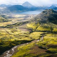
Landmannalaugar is a remote outpost in southern Iceland. This is the start of the Laugavegur Trail, a 34-mile trek through an astounding diversity of terrain — all of Middle-earth (minus the orcs) — plus, according to the guidebook, there is a shack, somewhere in the middle, that serves beer. The plan usually is to do it in four days and to stay in huts along the way.
You find yourself on the Icelandic equivalent of a Greyhound, cruising down the highway, when the bus driver makes a sharp right turn, onto a vast expanse of black sand, fringed by distant mountains. And you just kept going. The bus approaches a narrow river and plows into the current. It briefly appears as if you’re in a boat, surrounded by water.
The trail is well marked, the warden explains, with poles every hundred yards or so. And there are plenty of other hikers. The only dicey area is the first mountain pass, just before the hut at Hrafntinnusker, where you would spend our first night. Snow and fog sometimes obscure visibility here. “You can always turn around or dial 112 on your cellphone in an emergency,” he says. Several years back, a young Israeli died on this very pass, in a freak summer blizzard; and he wasn’t the only one to perish. “We usually have one death every two years,” another warden said.
You climb up a series of gentle slopes through a vaguely lunar landscape. (It is readily apparent why, in the 1960s, astronauts trained in Iceland for their visit to the moon.) You soon gaze down into Vondugil, the so-called Wicked Valley — a place that shepherds historically avoided because of its evil spirits — and which seems aptly named, as it lays shrouded in a gloomy mist.
Last summer, a group of intrepid local hikers discovered a way to hike around the entire Chicago metro area in one go. It’s called the Chicago Outerbelt, an uninterrupted 210-mile nature trail that pieces together existing forest preserves and park land into one contiguous loop. With highlights along the trail ranging from scenic lakes and rustic campsites to forested woodlands and lakefront beaches, let no one ever tell you again that there’s no such thing as nature in Chicago. You just gotta know where to find it.
Simply put, the Chicago Outerbelt is a trail that connects some of the best nature surrounding the city. It extends from Downtown’s Buckingham Fountain to the south suburbs, west to the Des Plaines River Trail, up north to Lake County, and finally back south along the Chicago lakefront. Primarily it consists of municipal properties pieced together for the first time – like the Cook County Forest Preserve District, Chicago Park District, and Lake County Forest Preserves.
“You just get this weird combination of green space and rolling hills and then you pop out and you can have a beer at Imperial Oak,” says REI outdoor programs coordinator Emily Leu, who was one of the first to hike the full trail with a small group of urban hiking explorers over two weeks last summer. “You get the best of both worlds.”
Along the Outerbelt, you’ll see a vast cross-section of wildlife including deer, herons, egrets, eagles, hawks, frogs, toads, and fish. The only dangers you’re likely to encounter are some poison ivy, a few bug bites, and maybe a little sunburn.
The gentle hills of Greater Boston aren’t exactly known for their heart-pumping hiking trails. The same goes for the sloping dunes of Cape Cod — you’d be hard-pressed to find gaggles of Lands End-clad hikers trekking out to sandbars in Eastern Massachusetts the way some groups scale the mountains of Western Mass. And that’s exactly why it’s so wondrous to go hiking there.
Indeed, one of the region’s biggest strengths as a hiking destination is a refreshing lack of other humans. Maybe uncrowded trails are a given, but until you go for a leisurely stroll among centuries-old trees — without seeing another person for hours — you might not understand the magic.
The other thing that makes this overlooked spot shine is its varied landscapes. There’s the option to climb a 635-foot hill to see views of the Boston skyline in the Blue Hills, or just 14 miles down the road, find flat walking trails that meander through abandoned military bunkers at Wompatuck State Park. Pleasant pond walks, island adventures, and foliage-filled journeys are all within an hour’s drive of each other.
The Great Island Trail is arguably one of the best hikes in all of Massachusetts. The loop, located within the boundaries of the Cape Cod National Seashore, begins with an easy walk tracing the shoreline of “the gut,” where the Herring River lets out into Wellfleet Harbor. Then, it climbs up into a pitch pine forest, offering stunning views from cliffs overlooking Cape Cod Bay.
Tom Courtney had a revelation in 2006, while hiking up to the top of a ridge in the Marin Headlands for the spectacular view he knew awaited him. When he finally reached the summit, he was able to see 38 miles clear to the north, all the way to the enduring peninsula of Point Reyes, with endless stretches of green and blue between.
It was a sight to behold, but Courtney soon found himself wondering how he could get from here to there. He wondered: Could he, an avid hiker who had hiked from inn to inn across various countries in Europe, hike those 38 miles? And what charming inns could he rest his head at along the way? Courtney opened his maps and began calling in reservations along the route.
It was the beginning of Courtney’s love for inn-to-inn hiking, a style that allows hikers to leave the gear behind and focus on their stride and the nature surrounding them. Most inn-to-inn hikers need only a minimal day pack of 12 to 15 pounds, with most of it comprised of water, along with a first-aid kit, flashlight, cell phone, and rain jacket.
Over years of research, Courtney was able to compile his knowledge into a book called Walkabout Northern California: Hiking from Inn to Inn, which included hikes across the north, south, and interior of the state. A separate book, Walkabout Malibu to Mexico, came out soon after. This year, Courtney updated his Northern California guide with current information on inns and nature trails, plus new color photos.
Lebanon, a country on the eastern shore of the Mediterranean that predates recorded history, boasts remarkable geographic and cultural diversity despite being smaller than Connecticut. Eighteen religious sects live in its snow-capped mountains and fertile Bekaa Valley and along its rocky coast. For more than 10 years, intrepid hikers have been able to experience much of this natural beauty and meet the communities far from urban centers along a hiking trail that runs from one end of the country to the other. This past spring, the president of the republic formally endorsed the trail, officially recognizing its place in Lebanon’s heritage and making now the time to make the trek.
The country’s plurality, always in a fragile balance, was ruptured in 1974 when Christian, Muslim, and Druze neighbors turned on one another in the Lebanese Civil War, a conflict that lasted 15 years. By the late 1990s, many who had fled the country during the conflict began to return, including Joseph Karam, a Lebanese-born sustainable development entrepreneur.
An avid hiker of the Appalachian Trail in the eastern United States, Karam believed that Lebanon’s extraordinary landscape and heritage were just as worthy of a long-distance trail. He was also convinced that by promoting ecotourism, such a route could heal rural communities struggling to recover from the conflict, uniting former adversaries through a shared love of the land. In 2005 Karam and a colleague submitted a proposal for funding from USAID and formed the Lebanon Mountain Trail Association (LMTA). Just two years later, the Lebanon Mountain Trail (LMT), a 293-mile highland corridor connecting well-worn shepherd and agricultural routes with ancient Phoenician and Roman footpaths, officially opened.
Every trail has rules, and often there are signs not just at the trailhead but also along the trail to remind hikers of what to do and what not to do to respect the environment.
However, some of the guidelines for hiking seem to get overlooked time and time again, either out of lack of knowledge or intentionally.
The State Trail Programs Manager for Colorado Parks and Wildlife, answered a few questions about trail etiquette based on the most commonly violated rules.
Why is it important to stay on the trail?
What’s the big deal if someone relieves themselves right off the trail?
What’s the harm in feeding the wildlife?
If a dog is friendly, why does it have to be on a leash?
Who has the right of way: hikers going uphill or downhill?
See answers to these questions and more here…
Going to the grocery store with small children can seem like a monumental task, never mind taking your brood on a wilderness journey. But with a little patience, some practice, and a healthy dose of expectation management, you can make hiking a family affair.
Keep in mind, there will be good hikes, bad hikes, and “Why are you rolling in poison ivy?!” hikes. Treks with tykes are worth it, because you want them to value nature and, eventually, to defend it.
Your primary goal is to get your child out there and having fun, so prepare to start small, and in some cases… really small. Those first few “hikes” may only be a quarter mile, but celebrate like your preschooler just finished the AT.
You want them to feel successful right away, so they associate hiking with feeling good. Conversely, don’t stress if things don’t go well the first few times. Like hiking itself, there will be ups and downs (and maybe some crying).
Think of other things your child enjoys and use them to sell hiking. Does she love animals, climbing, streams, or dirt? Hiking has all of those. If that doesn’t work, you may need to resort to good old-fashioned bribery.
Here are 10 baby steps that’ll help you make the most of family time on the trail…
You’re off for a ramble in the woods. The trail is narrow, the brush is thick. Everywhere you look – trees, bushes, greenery.
Then you spot it, half-hidden, nestled against a fallen, rotting log. You go up for a closer look to be sure that what you think you’re seeing is what you’re really seeing.
But there it is – a disembodied baby doll’s head! Set up as a little art display no less.
And then you see another, and another, along with other discarded, weather-worn objects that are a veritable parade from the Island of Misfit Toys. Where on Earth are you?
Well, you’re mere miles from the world’s busiest airport and literally yards outside the city limits of Atlanta, Georgia.
Welcome to one of the strangest, most semi-disturbing/semi-delightful travels you may ever take – hiking on the Doll’s Head Trail.
 I am Jeff Clark, founder of Internet Brothers, producer of this blog, and passionate about hiking. I live in Western NC near the Blue Ridge and Great Smoky Mountains. Pisgah and Nantahala National Forests are just out my door, so the content will focus on these areas, but let me know what you would like to see on the site.


Copyright © 2011-2023 Internet Brothers. All Rights Reserved. ISSN 2324-6057
Designed by Elegant Themes | Powered by Wordpress | Logo by Design Aspirations