You’ve got your hiking boots on, your worries left at home and a trail in front of you. You’re surrounded by dense nature, no sounds of buses or chatter, just the calming sounds of birds singing and a breeze whistling through the trees. You can feel the sun on your skin, you fill your lungs with perfectly fresh air and can smell the environment around you. All the while you feel warm and alive from this therapeutic, whole-body workout whilst you move through the natural world. Welcome to the world of hiking.
Hiking really is an incredible thing: medicine for the mind, body and soul. An activity you can do in almost any place around the world, for no cost and for pretty much any length of time. Besides the personal benefits, the time spent in the wilderness can also help people value and appreciate their surroundings, ultimately leading to more sustainable lifestyles. It’s something so good scientists, politicians, magazines and newspapers are constantly singing its praise.
Basically, no matter who you are, where you live or what you do, hiking will be an incredible addition to your life, but sometimes it’s hard to know where to start.
In this guide to hiking for beginners you’ll learn…
What is hiking?
Benefits of hiking
How to plan and prepare for a hike (incl. picking the right hike and how to find the best trails)
What to pack hiking
What clothes to wear hiking
Hiking foods and water
Hiking safety tips
What to do post-hike
How to stay green and respectful on the trail
To appreciate what Bill Thomas did for Gorges State Park, think of it not as a stand-alone property but as part of the larger Lake Jocassee watershed. Also known as Jocassee Gorges, it is a freak of climatological and geologic nature that extends across the North Carolina-South Carolina line southwest of Asheville and has been named by National Geographic as one of fifty “World’s Last Great Places.”
The ancient crash of tectonic plates that created the Appalachian Mountains pushed up the Blue Wall on the southeast edge of the mountains and formed the bones of the lake’s basin and the maze of gorges above it. The 2,000-foot wall catches moisture from clouds drifting up from the Gulf of Mexico, creating an annual average of 91 inches of rain (and a whopping 136 inches in 2018) that feeds four landmark rivers, the Thompson, Toxaway, Horsepasture and Whitewater. Their destination-worthy cascades include Whitewater, Rainbow, Turtleback and Windy falls.
Thomas, taking in the views at Gorges State Park, thought about what this land could have been— a vast zone of hydroelectric projects, its famous waterfalls funneled through pipes, its wild rivers cooped up in basins designed to flush like toilets to produce surges of power.
He thought about what it has been instead for the past 20 years—a safely preserved wonderland of deep ravines, plunging rivers and rare plants.
Thomas, 91, a retired chemical engineer, made an unpaid, late-life career of doing good things for the environment, applying his passion for the outdoors and brilliant, Princeton-trained intellect to a series of causes, including the blocking of a luxury subdivision planned for the heart of DuPont State Recreational Forest.
There are 11 designated national scenic trails stretching across nearly 18,000 miles in the U.S. But there are more than 4,000 miles of privately owned “gaps” in the system that leave routes vulnerable to a change in ownership or a landowner’s whims.
Typically, the government or nonprofit trail associations work to fill such gaps by purchasing land from willing sellers. But Jim Kern, founder of a new advocacy group called Hiking Trails for America, says the only way to protect every mile of those trails forever is through the use of eminent domain.
A power granted by the Fifth Amendment of the Constitution, eminent domain allows federal, state, and local governments to acquire private land for public use in exchange for “just compensation.”
The Appalachian Trail is the only national scenic trail owned entirely by the public and the only one for which the U.S. government has invoked eminent domain. The National Park Service says it acquired 15,266 acres along the trail via compulsory purchase, mostly between 1986 and 1997, out of nearly 150,000 total acres acquired to complete federal ownership of the land.
The other ten trails, like the Pacific Crest Trail, rely partly on agreements with private landowners, which guarantee rights of passage for hikers. But if lands are sold, or if an owner decides against allowing hikers on their property, it could force a trail to reroute or run alongside developed land instead of the wilderness. “It leaves a lot of uncertainty as to what might happen.”
They call themselves the “Honeymoon Hikers” and they just completed their fourth hike of the Appalachian Trail.
Winston and Marcia Terry have done a lot of hiking since they got married in 2010. The couple has hiked 14,000 miles together.
While there are no official records, Marcia is believed to be the only woman who has made four complete trips on the AT.
But how did they get their trail name, the “Honeymoon Hikers?”
“We got married on the trail after we thru-hiked in 2010, we went back to Springer and had a hiker wedding,” Winston said. “And we decided for our honeymoon in 2012, we’d hike the trail again. And we summited Mount Katahdin on our one year wedding anniversary.”
Winston and his daughter had a plaque made for Marcia commemorating her fourth thru-hike. He presented it to her when they arrived in Damascus, Va.
The long-awaited Historic Columbia River Highway State Trail is still at least a couple years from completion, but the latest trail segment to open to the public proves that patience can pay off.
A new three-mile section of the trail opened to the public, connecting Wyeth State Park to Lindsey Creek where it meets up with another trail segment that opened in 2016.
That means cyclists and hikers now have a designated, protected pathway that runs nearly six miles along the Columbia River Gorge, from Wyeth State Park to Viento State Park. That route runs past waterfalls, hiking trails, a campground and spectacular views of one of the most scenic destinations in the Pacific Northwest.
When complete, the Historic Columbia River Highway State Trail will run 73 miles connecting Troutdale to The Dalles, retracing the original scenic highway that was partially destroyed in the construction of Interstate 84. While parts of the trail will be on the new, protected pathway, other sections will run along the Historic Columbia River Highway, sharing the road with cars.
All that remains to be constructed is the five-mile Mitchell Point segment, which requires either blasting a tunnel or building a bridge to connect the western trail segments to Hood River and The Dalles.
As the dog days of summer continue, temperatures continually reach or surpass the 90° degree mark. These temperatures bring about dangerous conditions if you don’t pay attention to heat-related illness signs.
Heat-related illnesses include heat stroke, heat exhaustion, heat cramps, sunburn and heat rash. Symptoms of these illnesses can cause nausea, vomiting, muscle cramps, dizziness, confusion, headaches and fainting.
If any of these symptoms are observed, the Centers for Disease Control and Prevention recommends moving to a cooler place, drink water, and stop physical activity.
According to the Mayo Clinic, a high heat index is a major contributor to heat-related illnesses. The heat index is a single temperature value that considers how both the outdoor temperature and humidity make you feel. When the humidity is high, your sweat can’t evaporate as easily and your body has more difficulty cooling itself, making you prone to heat exhaustion and heatstroke. When the heat index is 91 F (33 C) or higher, you should take precautions to keep cool.
See a guide on what to look for, and what to do…
It’s the time of year when summer hiking is at its peak — and so are streams of headlines about missing hikers. Wandering off the trail is the most common reason people get lost.
You never want to be that person. And if you do get lost, you want to stay safe and get found. Quickly. The best advice, of course, is not to go missing in the first place.
“We teach ‘stay found,’” says Jane Simpson, chairwoman of the Sierra Club Angeles Chapter’s Wilderness Travel Course, a popular outdoor skills course with a strong emphasis on navigation. “I can’t emphasize enough the importance of learning navigation basics, which really boils down to common sense. Even if you don’t take map-and-compass training, know where north and south are, where you started, and basically where you are in the world.”
By that Simpson means paying attention to your surroundings, which begins before you leave your house. Look at an online map or go to Google Earth for a basic orientation. Will you be hiking a ridgeline? Dropping into gullies? What prominent peaks are visible in the vicinity? Any stream crossings?
On the trail, carry a paper map, she advises, even if you use a smartphone app such as Gaia GPS that tracks your route. “Even a sketchy map will point out major features: Mountain X, River Y. Though you do need to know how to orient it. You need to know north and south.”
But what if after all that you still get lost? Here are six tips to help you get found…
The world is very connected now because of phones, tablets and computers. This allows people to be almost constantly connected to their families, coworkers and even strangers. While modern technology can help to improve efficiency, broaden knowledge, and widen social networks, it also has increased screen dependence, particularly on mobile phones. Hiking gives everyone an opportunity to disconnect from the screens and all of their related issues and make different connections instead.
Getting outside to one of our many trails allows people to connect first with their area’s unique natural features. Hikers can observe beautiful seasonal wildflowers, glimpse many types of native wildlife and learn about the unique geology. Hikers who are reluctant to completely disconnect from technology and who are curious about the plants and animals they encounter on the trails might like to use the iNaturalist app to identify unfamiliar specimens by simply uploading a photo via their phone. Mobile phones also can provide help in case of an emergency.
Hiking also provides opportunities to expand social networks by connecting with people in the community. Since anyone of any fitness level can participate in this activity, local trails attract seniors, families with children, solo hikers with dogs, fitness groups, long-time residents and out-of-town visitors. Speaking with strangers on the trails can range from a simple “hello” to detailed recommendations for other trails to explore.
Finally, hiking is a chance to reconnect with oneself. Many people find the freedom to release frustrations and think about personal challenges out in the woods, away from daily routines and pressures. Hiking is a peaceful way to clear the mind in order to perform more effectively when returning to the real world.
Hiking boots or trail runners?
Years ago there wasn’t a choice. Leather hiking boots ruled the trail. But trail runners are now king of the mountains, and they far outnumber boots in outfitters’ displays. Still, footwear is a highly personal choice, and what works for one hiker may not work for another.
The outsoles of boots give the bottoms of your feet a solid layer of protection from the pounding you’ll get from rocky trails. Boots give you stability on trail, and the more stable your foot the smaller chance of rolling an ankle. Boots alone will not help hikers with weak ankles. But the boot uppers will protect your ankles if your foot accidentally slides into a narrow gap between rocks or bangs against a protruding stick. Boots might be the better choice for hikers carrying heavy loads of 30 pounds or more because of the outsoles’ thicker protection.
For shorter hikes where there is no soggy ground or forecasted precipitation, dry time may not be an important consideration. For longer backpacking trips, where you’re likely to encounter river fords, hiking on snowfields, or through torrential rain, dry time is an important consideration. Hiking for prolonged periods in wet shoes or boots can be very uncomfortable and result in blisters, trench foot, or a host of other foot issues. Trail runners dry a lot faster.
Who wins? You be the judge. The Trek asked two longtime hikers to weigh in on their choice of footwear…
2018 marked the 40th anniversary of the Continental Divide Trail (CDT), the 50th anniversary of the National Scenic Trails Act, and the year Big Agnes became a steward over 75 miles of trail. To celebrate, all 70 employees hiked and biked the 740-mile length of the CDT’s Colorado section.
Now a year removed from that epic adventure, Big Agnes launched its own CDT trail guide to aid would-be thru-hikers. It contains technical information, like section distances, elevation change, high points, water sources, and more. But it also has photos, stories, and other first-hand accounts from the Big Agnes team.
“The trail inspires us in so many ways – from gear we develop to the outdoor activities our staff gets after,” Big Agnes co-founder and president Bill Gamber said. “Whether for a day hike, an overnight, or a complete thru-hike, we hope this online resource makes the CDT more accessible to more people.”
In all, the guide comprises 22 sections of trail, beginning with the New Mexico border to Wolf Creek Pass and ending with the North Lake Trailhead to the Colorado-Wyoming border.
Inside each section, Big Agnes provides a rundown of the team’s experience for that section and technical data, along with a list of skills needed for that hike (snow hiking, lightning and widowmaker safety, etc.) and some pro tips. The brand also includes helpful links to Leave No Trace tips, U.S. Forest Service info on nearby attractions, and the paid Atlas Guides app.
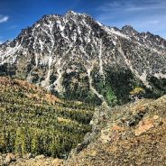
The Longs Pass Trail, on the east side of the Cascades Mountains Range, is seven miles round trip, with a net gain/loss of 2,100 feet. The pass itself is at an elevation of 6,250 feet.
The well-marked and well-maintained trailhead is due east from the parking lot. It is a steady climb from its start in the cool forest of the valley. It slowly transitions to exposed rocky slopes filled with summer wildflowers.
As you gain elevation, the views to the north open up and reveal colorful rocks, avalanche paths carved into steep slopes, and some lingering patches of snow. Closer to the top, there are a few short switchbacks, and the view continues to expand. If you look backward over your shoulder, more and more of Mt. Rainier towers above the mountains to the west.
Before you know it, three miles has gone by and you cross some wildly colored talus slopes. Then you hit the bare, rocky crest of the windswept ridge and … voila – a knock-your-socks-off take-your-breath-away full-face head-on view of Mt. Stuart.
You can linger and soak up the majestic views, take a nap in the sun, or scramble up the ridgelines to the north and to the south to get a little higher.
Liz “Snorkel” Thomas set the women’s fastest known time for a self-supported hike on the Appalachian Trail in 2011 and has since become an urban-hiking advocate. She recently completed a nine-day, 225-mile thru-hike across New York’s five boroughs. Her goal was to visit 100 playgrounds to highlight the Trust for Public Lands’ (TPL) project to build such facilities throughout the city.
Having grown up in the suburbs of Sacramento, California, Thomas says, “I took trees and grass for granted in my schoolyards. The green space was almost a gateway drug for me to get more into nature, into hiking.” But in New York City, nearly three-quarters of low-income neighborhoods fail to meet the city standard of 2.5 acres of parkland per 1,000 residents, according to the TPL. The lack of outdoor space exacerbates the risk of obesity, diabetes, and other health risks for children there.
The TPL has spent more than $180 million over the past two decades in a public-private partnership that has resulted in 200 new playgrounds in New York City, and it’s currently fundraising to complete 40 more that are in the design process. “Our goal is to provide access to parks and playgrounds to kids who don’t have that benefit,” says Mary Alice Lee, director of the New York City Playgrounds program. “We design the playgrounds in collaboration with the students in the schools to build enthusiasm and empower the kids.”
Their greatest desire? “Trees. They just want some trees by their schools and some turf fields to play on,” says Lee. Seemingly simple goals but a complex project, given the size of the city and the funding needed. “It’s great that Liz is bringing some attention to our program.”
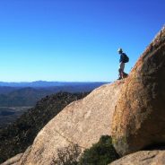
In the American Southwest, only 120 miles from one of the largest cities in the country, lies an outdoor and recreational wonderland of lakes, mountains, and desert just waiting for those who seek adventure and the chance to bring home a story. This astonishing place where “the desert meets the pines” is Prescott National Forest in Central Arizona, a year-round destination for camping, fishing, horseback riding, off-highway vehicle touring, and other exciting outdoor activities.
Prescott National Forest is guardian of more than 100,000 acres of wilderness, and part of a much larger area of protected lands as it borders three other National Forests in Arizona – Coconino National Forest, Tonto National Forest, and Kaibab National Forest. Prescott National Forest offers nearly 450 miles of scenic trails for hiking, backpacking, horseback riding, and mountain biking. The forest also contains a National Recreational Trail (Granite Mountain Trail) and a National Historic Study trail (General Crook Trail), and, with the mild climate of the area, visitors can enjoy hiking the trails year round.
Prescott National Forest also provides access to the Verde River, with opportunities for motorized boating, kayaking, and fishing. Once an active gravel pit, the Alto Pit in the forest is now a haven for off-highway vehicles like dirt bikes and all-terrain vehicles. The 20-mile trail system offers something for everyone, with challenging rides for advanced recreationists and exhilarating learning opportunities for beginners. For more thrill-seeking visitors, Prescott National Forest has you covered with hang gliding, technical rock climbing and bouldering, and whitewater rafting.
When it comes to camping, the forest delivers a range of unique campsites and historic cabins that offer pine-clad mountain hideaways, rustic indoor retreats, and stunning stargazing spots. The best part of all is that there’s still a chance to plan a summer escape to this Arizona oasis.
Knowing what to bring with you on a hiking adventure can be daunting, because there are so many factors that might influence what you should pack and such a variety of products to choose from.
Beginners may find the process of matching a walk in the woods with the right gear overwhelming at first, but even an expert might be daunted when preparing for a hike that is longer, colder, dryer, wetter, higher or faster than they’ve experienced before.
US website Bugaboo is trying to make the process of selecting backpacking gear easier by enabling hikers to find, build, and share gear lists for their next adventure.
“The problem is that dozens of factors influence what you should and shouldn’t bring with you on the trail,” it says. “Season, elevation, wildlife, terrain, climate, daylight hours, not to mention your own personal interests and objectives. A traverse of the Pacific Crest Trail in winter requires vastly different gear than a weekend in the Smokies with young children. It doesn’t help that there are a thousand products to choose from in nearly every gear category.”
Each hiker creates gear lists based on their own experiences on the Bugaboo site and then shares those lists with the community. So if you’re getting ready to go backpacking for the first time or going to a new area, you can find gear lists from people who’ve been there and done that.
Say hello to 15+ hours of daylight, refreshing mountain streams, and endless miles of green tunnel. That’s right. It’s summer in the Appalachians which means hiking season is in full swing. While summer on the AT can be one of the best times of year, certain parts of the trail are better than others to hike during the warmer months.
With 2,200 miles of trail, it can be hard to sort through each state’s weather patterns and find the perfect conditions for your summer backpacking trip. To help, we’ve pinpointed the sections of the AT with the most ideal conditions and must-see sites during the summer months.
The list includes places to help you avoid humidity, extreme heat, and dry water sources, as well as make sure you see some of the best known summer sites along the trail. Lace up your boots (or trail runners) and get inspired for your next summer adventure with the best places to hike on the Appalachian Trail this summer.
Roan Mountain is the only section of trail featured on this list that isn’t in New England. Usually humidity, dry water sources, and intense heat lead hikers to more northern sections during the summer, but there is something that Roan Mountain has that New England states don’t: Rhododendrons.
Hiking with a child won’t be the same as hiking with adults. The goal with kids is much more about the journey than the destination. Here are four basic ideas to keep in mind:
Modify your goals. You may not reach the end of the trail. You may not even hike a mile. Adjust your hike to the enjoyment and comfort level of children.
Pack patience and flexibility. If you see a frog dart across the trail, be prepared to stop and wait to watch for that frog to dart across the trail again. Use teachable moments to explore the natural world.
Know what features are ahead. For starter day hikes, choose short trails that do not have much elevation gain, but do have features like lakes, ponds or waterfalls along the way. Children are fascinated with water.
Dress for success. Check weather conditions and be prepared. Bring dry clothes, even if rain isn’t in the forecast, your kiddo is likely to find a way to get wet. (Probably in a creative way you wouldn’t expect.)
If you live in the western Washington area, here are six great hikes for kids…
By almost any standard, Hawaii’s hiking trails are a world-class recreational resource. The state’s trail system alone encompasses 855 miles of trails and access roads, from epic, remote routes like the Kalalau trail on Kauai’s Napali coast to easily accessible day hikes like the 2.5- mile Makiki loop trail. And that doesn’t count trails run by the counties or the National Park Service.
But hordes of tourists have made the system increasingly difficult to manage. The number of visitors to Hawaii is expected to top 10 million this year. Those numbers, combined with the increasing popularity of hiking and the popularization of even the most remote trails, are creating lots of stress for trail managers.
The results are well-known to residents: cars clogging residential streets around trailheads, eroding trails, hikers getting lost or injured or simply ignoring no trespassing or warning signs.
One major new initiative could help state officials at least quantify the demand, which for now remains largely unknown. Although there’s plenty of anecdotal evidence that many trails are growing increasingly popular, gathering data is difficult. With only a few exceptions, trails don’t typically have monitors or attendants counting people at the trailheads. The state might consider limiting the use of some trails, but first it needs to know how many people are using them.
A proposed hydropower transmission line in Maine would impact the AT, wildlife, recreation, and tourism. Is it worth it?
The proposed project, known as New England Clean Energy Connect (NECEC), is a 145-mile transmission line winding down from the Canadian border through Maine’s forests, and would ferry hydroelectric energy from Canadian dams to the New England grid. It would cross the AT three times within a mile, south of Moxie Pond and about 130 miles from the trail’s momentous conclusion at Mount Katadhin, impacting views from several overlooks.
“There’s a certain awe in thru-hikers, especially those who are coming from the South,” a local said. “They’ve just hiked on these regions where there are a lot of reminders of civilizations, road crossings, and infrastructure. What I’ve heard from them is that Maine is more noted for having that backcountry experience.”
Many of the opponents of NECEC—65 percent of Maine residents are not in favor of the project-according to a recent poll—worry that the line will threaten this scenic character. Maine’s northern woods have been relatively spared from development. They have a legacy of sporting camps; offer hiking, rafting, fishing, kayaking, snowmobiling, and other recreational opportunities, all of which support a robust outdoor industry and local economies. While the exact impacts of the line are up for debate, those who oppose it fear it would bifurcate “what is basically the largest expanse of undeveloped forest in the eastern United States.”
 I am Jeff Clark, founder of Internet Brothers, producer of this blog, and passionate about hiking. I live in Western NC near the Blue Ridge and Great Smoky Mountains. Pisgah and Nantahala National Forests are just out my door, so the content will focus on these areas, but let me know what you would like to see on the site.


Copyright © 2011-2023 Internet Brothers. All Rights Reserved. ISSN 2324-6057
Designed by Elegant Themes | Powered by Wordpress | Logo by Design Aspirations