
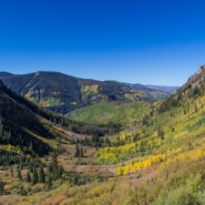
Beginning on Columbine Dr. in East Vail, CO, the Bighorn Trail climbs steeply out of the Vail Valley, then more gradually climbs up through stands of aspen and pine. The trail passes beaver ponds and the remains of old mining camps as well as Bighorn Creek. Near the halfway point, be sure to turn around because the views of Vail and Bighorn drainage behind you are...
Learn More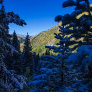
Booth Lake Trail begins at Booth Falls Road in East Vail, CO and ends at Booth Lake. The trail climbs up the Booth Creek valley through mostly aspen groves before passing the 60-foot Booth Falls. Beyond the falls the trail winds through conifer forests and meadows filled with wildflowers. Above 10,000 feet the trees thin and the terrain changes offering views of the Gore...
Learn More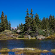
One of the things I miss about the Blue Ridge and Smokies is mountain lakes. The Rocky Mountains are adorned with memorable alpine lakes, usually surrounded by majestic peaks and bountiful evergreen forest. All you need is an input and output source, like Fall Creek in the case of Lake Constantine, and a bowl between mountains to collect the water. Fall Creek Trail...
Learn More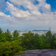
Carl Sandburg’s wife Lilian discovered the mountain farm named Connemara in the community of Flat Rock, south of Asheville, NC. From 1945, until his death in 1967, the famous American poet, biographer, and Pulitzer Prize-winning author lived and worked on the 264-acre estate. The family then sold the property and donated the contents to the National Park Service...
Learn More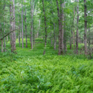
Peaceful. If I were to think of a single word to describe the Pink Beds Loop Trail, that would be it. Peaceful. Located in a high valley in the Cradle of Forestry, Pink Beds is surrounded by the tall mountains and lush woodlands of Pisgah National Forest. Home to rare mountain bogs, unique vegetation, and unusual wildlife, this area is ideal for those who like to explore...
Learn More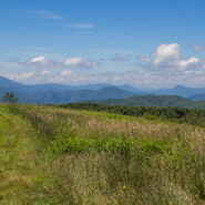
High above the community of Erwin, Tennessee, the Appalachian Trail follows the North Carolina / Tennessee state line through the Unaka Range. From a grassy bald ridge with the appropriate name Beauty Spot, to the summit of 5,184′ Unaka Mountain, the trail winds northeasterly for a 4-mile section through a continuously changing ecology. Stand on the bald with...
Learn More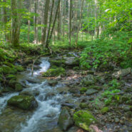
Looking to do some ridge hiking down, down, down from the Blue Ridge Parkway into Pisgah National Forest? Overlooking North Mills River, the Little Pisgah Ridge starts at 4,800′, then drops down into the Big Creek drainage some 2,100 feet below. Catch your views of the mountains on the Parkway before you start because this is a heavily forested hike that instead...
Learn More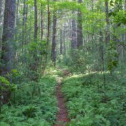
Sometimes even the most benign little trail can be filled with wondrous surprises. Nestled in a small valley between Bryson and Caney Mountains in North Mills River, North Carolina, and surrounded by Pisgah National Forest, the Foster Creek conservation easement and trail is just such a place. Barely a mile in length, and nearly flat, this four-season trail is ideal for...
Learn More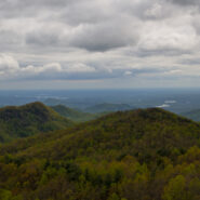
Hiking a state line offers interesting boundary markers and competing blaze markings. This hike on the Foothills Trail follows the boundary from the highest point in South Carolina — Sassafras Mountain — to a convenient end point at Gum Gap in North Carolina. Because of the length, for us this was a two vehicle hike, with one left at each end. Expect a roller...
Learn More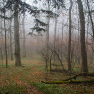
Back to Rough Butt Bald Overlook on the Blue Ridge Parkway, and another visit to the Mountains to Sea Trail. The MST follows, or remains close to the Parkway through much of Western North Carolina, so there are a number of easily accessible jumping off points that head into the backcountry. Middle Prong Wilderness was designated in 1984 and spans rugged high-elevation...
Learn More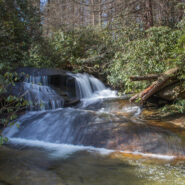
There is a series of waterfalls not far from the Pisgah Center for Wildlife Education and State Fish Hatchery on Forest Road 475. Collectively known as Cedar Rock Falls, they carry Cedar Rock Creek on its plunge down the mountain to Davidson River. Access to these falls and the wetlands beyond is via the Cat Gap Trail, a jumping off connector trail for many of the...
Learn More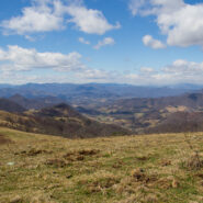
The Rough Creek Watershed is 870 acres of protected mountain land north of Canton, North Carolina, in Haywood County. This is privately held land, so there are rules for hikers and mountain bikers, but it is open to the general public. The trail system is more than 10 miles, and incorporates historical road beds with well maintained single tracks for foot and bike...
Learn More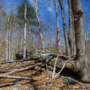
Perhaps you’re looking for a short hike that will really stretch your legs and get your heart pounding. Then you may want to consider the Pressley Cove/Maxwell Cove loop that is not too far from the Pisgah Ranger District headquarters. You’ll climb more than 1,400 feet in just a little over a mile through a beautiful poplar, oak and beech one-age forest....
Learn More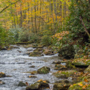
One of many trails found off Forest Road 475 in the Pisgah Ranger District near the State Fish Hatchery, Daniel Ridge Loop is a beautiful 5-miler that takes you near the headwaters of Davidson River. As you climb the ridge you’ll have views of the Looking Glass and Cedar Rock plutons on the south side, and drainage off four ridges into Davidson River on the north...
Learn More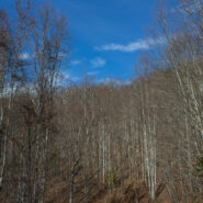
North Mills River Recreation Area in Pisgah National Forest, along with its brother at South Mills River, has a rich and varied trail system. Among them, Fletcher Creek is a typical streamside trail that passes an old beaver pond, thick forest of hardwood and hemlock, several grassy meadows and a number of log bridge crossings over Fletcher Creek, Spencer Branch and...
Learn More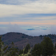
Between mileposts 423 and 424 on the Blue Ridge Parkway, Scenic Hwy 215 crosses at Beech Gap. If you head about 1/4 mile north on 215, the famous Mountains to Sea Trail crosses from the Black Balsam area into Middle Prong Wilderness. The MtS winds through an ever-changing forest that runs the gamut of evergreens found in the high country of Western North Carolina. Past...
Learn More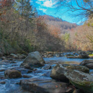
Green River Game Lands, southeast of Hendersonville, NC, sits astride the Henderson/Polk County line. Paralleling the Green River Gorge, the Game Lands is a state owned tract of more than 10,000 acres with 16 miles of hiking along nine distinct named trails. As its moniker would imply, hunting, fishing, and trapping are allowed on the Game Lands during the months of...
Learn More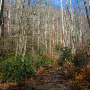
Just southeast of the Cradle of Forestry in Pisgah National Forest lies the Avery Creek area, a beautiful hardwood forest with plenty of water and a hidden pair of waterfalls known as Twin Falls. Access to the falls is via the Buckhorn Gap Trail, an easy to moderate track that first follows Avery Creek, then turns north alongside Henry Branch. The forest management work...
Learn More
Hickory Nut Gorge runs from Bearwallow Mountain in the northwest to Lake Lure southeast. Included in its 10-mile length are majestic cliffs of granite, inspiring waterfalls and scenic wilderness that beckons to the explorer in you. Chimney Rock State Park, Florence Nature Preserve and Rumbling Bald all offer excellent hiking within the gorge. Up in the northwest corner...
Learn More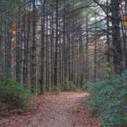
Deep at the southern tip of DuPont State Forest is an area loved by mountain bikers, but also a nice place for scenic forest, riverside, and small mountain hiking. The elevation is in the 2800-3000 foot range, so it’s ideal for winter hiking where you’re not likely to get deep snow like the 6000′ peaks in the nearby national forest. Start with a lovely...
Learn More
Another of the myriad of ridge and gap trails from North Mills River to the Blue Ridge Parkway. Bad Fork Trail follows its namesake creek from Forest Road 5000 to Bent Creek Gap at mile 400 on the Parkway. This is a four mile round trip that can be extended by continuing on the Mountains to Sea Trail on the north side of the Parkway. Only moderately steep, this is a nice...
Learn More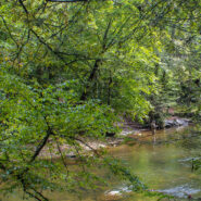
Section 1 of the Art Loeb Trail is in Pisgah National Forest near Brevard, NC overlooking the Davidson River Recreation Area. The North Slope Trail is a loop contained within the boundary created by the Art Loeb and the river. Between the two trails is a connector. Combining the two via the connector makes an 8-mile loop that takes in a large portion of the forest above...
Learn More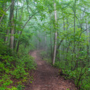
Bracken Mountain Preserve and Recreation Area is 395 acres of forested land owned by the town of Brevard in Transylvania County, NC. This municipal preserve is due west of downtown and adjacent to Pisgah National Forest and the Brevard Music Center. The town secured approval from the National Forest Service to build a connection with the established trail system, and to...
Learn More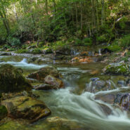
The southeast corner of Shining Rock Wilderness is filled with rivers, creeks and streams tumbling down from the mountains that rise above 6000 feet in the high country. Included among these waterways is the East Fork of the Pigeon River, otherwise known as Big East Fork. A trail follows the river from Hwy 276 to the confluence with Greasy Cove Prong and beyond. This Big...
Learn More
Nestled in the woods of Pisgah National Forest in Asheville, the North Carolina Arboretum is a 434 acre public garden located within the Bent Creek Experimental Forest. Set amid rolling hills just off mile 393 of the Blue Ridge Parkway, the Arboretum offers more than ten miles of groomed hiking trails that are suitable for all ages. Home to one of the finest, most unique...
Learn More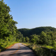
This is a two-part hike with a short drive on a forest service road in between. Both the Case Camp Ridge Trail and the North Face Trail start on Forest Road 475B in Pisgah National Forest. The first climbs 1000 feet in 1.7 miles to the Blue Ridge Parkway near Cherry Gap at mile 416. It’s a short walk from the trail to the Cherry Cove Overlook and a close-up view of...
Learn More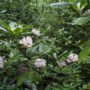
Another of the myriad of hikes along Forest Road 475 in Pisgah National Forest, this two-parter is near the Fish Hatchery and Pisgah Center for Wildlife Education. First we took a short trip up Forest Road 475B to Slick Rock Falls, then hiked to the base of Looking Glass Rock. The climbers love this area and we encountered some when we reached the base. The main hike was...
Learn More
Usually when you come here you will find a cheerful description of a scenic hike that was fun, and that I recommend for your enjoyment. Instead, I am going to suggest that you stay away from this hike if you value your safety and security. The Brush Creek and Burnett Gap Trails are so terribly maintained as to make them virtually impassible. I’m sure at one time...
Learn More I am Jeff Clark, founder of Internet Brothers, producer of this blog, and passionate about hiking. I live in Western NC near the Blue Ridge and Great Smoky Mountains. Pisgah and Nantahala National Forests are just out my door, so the content will focus on these areas, but let me know what you would like to see on the site.


Copyright © 2011-2023 Internet Brothers. All Rights Reserved. ISSN 2324-6057
Designed by Elegant Themes | Powered by Wordpress | Logo by Design Aspirations