
The Rough Creek Watershed is 870 acres of protected mountain land north of Canton, North Carolina, in Haywood County. This is privately held land, so there are rules for hikers and mountain bikers, but it is open to the general public. The trail system is more than 10 miles, and incorporates historical road beds with well maintained single tracks for foot and bike activity. The watershed contains nearly seven miles of streams, seeps, springs, and bogs. We saw lots of evidence of wild turkeys, while black bear and bobcat are also known to inhabit the area. Rough Creek Watershed is a nice year-round family hiking experience. This hike occurred on Wednesday, March 13, 2013 from 10:15am to 2:45pm. Our plan was to take the boundary loop around the full watershed with particular interest in the Cherry Cove Trail and its outstanding vistas of the Great Smoky Mountains.
Hike Length: 9.9 miles Hike Duration: 4.5 hours
Hike Rating: Moderate, some strenuous climbing
Blaze: Blue, red Elevation Gain: 1,660 feet Hike Configuration: Loop
Trail Condition: Excellent. Upper Cherry Cove Trail can get overgrown in summer.
Starting Point: Caretaker’s driveway to parking at the old water treatment building.
Trail Traffic: We did not encounter any other hikers on these trails, though we did hear some. There were four cars at the parking area, including ours.
How to Get There: From Asheville, NC take I-40 W to exit 33; go straight ahead onto Freedom Road; right onto Beaverdam Road (SR 1613) for 2 miles; left on Rice Cove Road for 0.4 mile; right on Rough Water Road to the end, about 0.3 mile. Open gate on your left, drive through, re-close gate and drive 0.3 miles to the parking area on the left.
I need to tell you about the entryway to Rough Creek Watershed, because it is a bit unusual. When you get to the end of Rough Water Road, you have to get out of your car to open the cattle gate on the left. Do not park outside the gate as that is all private property. Be sure to close the gate behind you once through. You will then drive up a steep one lane driveway to the caretaker’s quarters. Watch for oncoming cars as the road is very narrow. Once at the top, park on the left in the lot of the old water treatment building.
Rough Creek Watershed is still private property, owned by the town of Canton and managed by the Southern Appalachian Highlands Conservancy. As hikers and bikers we are invited guests. As such, we need to play by the rules. There aren’t many, and they won’t affect your enjoyment in the least, but they do help keep the experience great for everyone.
Once parked, walk toward the caretaker’s house, then look to your left for the trailhead. You’ll walk past a signboard, through a small pasture, then make a hard right switchback up the hill. You will then come to another gate, this one the entrance to the watershed. You can either crawl through, or climb over. Don’t worry, it’s ok.
The hardest part of this hike is the first mile, which suits my hiking style well. I like to get the tough climbing done early while I’m still fresh. My body does better when I climb first, then return down at the end. The other way? Not so good for me. You will climb 460 feet in that first mile, then another 320 feet in the 2nd mile.
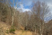
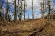
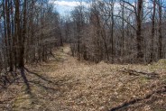
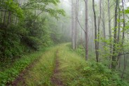
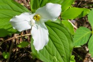
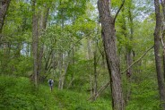
The trail is an old road bed that is in excellent condition for hiking, or mountain biking. It’s a soft, grassy track — not the usual gravel you find on most forest roads. Both sides are lined with a thick, rich forest of both hardwoods and evergreens. Look for hemlock and spruce, as well as poplar and beech, and of course the ever present North Carolina rhododendron. In spring you’ll find the occasional rare plant, painted trillium and whorled pogonia for example.
There is plenty of evidence of turkeys. They dig in the turf with their beaks looking for food, leaving exposed dirt mixed with the grass on the road bed. We also saw both cat and bear scat.
It’s 0.8 mile from the entry gate to the first trail junction. You want to turn left, to the southwest, toward Hood Gap. The trail signs don’t tell you places. They merely point direction. So get used to that. Having a map is very helpful. You will see an occasional blue blaze of a bear paw on trees by the trail. You’ll walk another 0.6 mile on this 2nd road.
The next junction is Hood Gap on the southern boundary of the watershed. You can follow the boundary to Wines Top, but for our hike we took a right turn (northwest) toward Cherry Cove Trail. That’s the trail that will take you to the top of the ridge and the wonderful views of the Great Smoky Mountains that surround Canton Valley. No visit is complete without it.
After a quarter mile or so, start looking for the Cherry Cove Trail to take off on your left. It is a single track trail that actually has a signed trail marker. And, it also switches to red bear paw blaze. We made note of where the trail was, and continued on the road bed toward the central watershed just to do a little exploring.
We nearly reached the junction with the eastern boundary of the property, then decided to turn around and head back to the Cherry Cove trailhead. On the way, however, we went up the Turkey Run Trail just to see what was there. This trail basically follows a similar path to Cherry Cove, but down below the ridge. We found a nice log for lunch on Turkey Run, so we rested and nourished for the final push up the ridge.
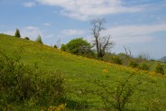
The Cherry Cove Trail is 2.5 miles in length and is the highlight of this hike. You will climb to the ridge the first half, then head to the northeastern watershed boundary the latter half. The climb is certainly easier than the roads, not nearly as steep, with plenty of switchbacks that take you in a mostly northward direction.
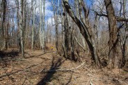
It’s kind of an odd forest. The trees aren’t nearly as crowded as the lower elevations, and all the ground cover is blown over and flattened by the heavy winds that swirl through the hollows.
We saw several bluebirds and heard the rat-a-tat of the pileated woodpecker as our feet swished through the dried leaves that were still covering the trail this late in winter. It’s not an especially attractive forest, but that just sets you up for what’s to come when you top the ridge.
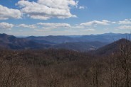
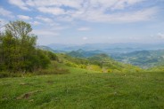
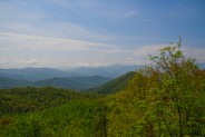
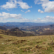
As we popped over the ridge and out of the woods onto another grassy road, the wind hit me like a slap to the face. Holy cow, it’s cold! The air temperature this day was in the high 30s, as was the wind mph. It was difficult to stand still to take pictures. There is a barbed wire boundary fence on the side of the road, and on the outside is… magnificence.
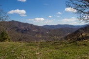
To the south are the Great Balsam Mountains that are so prominent in the high country on the Blue Ridge Parkway 40 miles away. To the southwest is Canton Valley with a backdrop of the Great Smoky Mountains. Due west are the Newfound Mountains, and beyond to Tennessee. Just across the fence is cattle country.
Dead cattle. Yep, it’s a bovine graveyard. There are cow skulls and ribs scattered all about the grassy hill on the other side of the fence. One would suspect they got trapped up top in a snow storm some years ago and simply starved to death. There are hundreds of acres of range land between the watershed and the Newfounds.
Did I mention it was cold? I couldn’t stand to stay in the wind for more than about a minute at a time, so I would rush back into the woods for a break. Then I would take a deep breath and head back out to the fence line for some more pictures, then scurry back into the woods. This went on for several minutes as we continued uphill along the grassy boundary road to the ultimate summit of Glade Mountain.
At the top, the fence turns left, to the northwest, and offers another nice view down valley into Canton. That’s the photo at the top of this post. Click it for a larger image. There are signs around indicating this is a conservation area protected by the SAHC. Hopefully anyone wandering onto the watershed property from the range will show the appropriate respect.
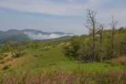
Once we had enough of the beautiful scenery, and wind, we continued back into the woods on Cherry Cove Trail. Not long after, we came to what is simply called “the overlook,” a large rock outcropping that looks to the east. There we had our first clear view of Big Butt Mountain (yes, that’s right), and even the landmark Mt. Pisgah at least 40 miles away. This view isn’t quite as spectacular as the western side, but I suspect it might be a nice place to experience a sunrise.
For more than a mile Cherry Cove Trail winds through the forest, crossing the occasional stream, and giving relief from the wind. We set a good pace through here as it’s a mostly level grade that is easy to hike. Eventually we came to the northernmost quadrant of the watershed, known as The Glades, a swampy area that isn’t accessible by trail. Here Cherry Cove Trail ends, you make a hard right turn southward, and begin the trek off the mountain on the eastern boundary road.
For the next couple miles we followed the boundary in roller coaster fashion, going down for awhile, then up for awhile, then down for awhile… There are a few mountain homes on this east side of the watershed, with lovely views of the surrounding terrain. We happened upon a few old hornets nests hanging from the trees, leftover from a year gone by. We reached a clearing along the boundary fence with a great closeup view of Big Butt Mountain.
As you continue south on the boundary road, you’re walking directly toward a steeply pointed mountain known as Rocky Knob. My friend started singing the favorite song of the University of Tennessee Volunteers, but it just wasn’t quite right.
Rocky Knob, you’ll always be
Home sweet home to me.
Good ole Rocky Knob,
Rocky Knob North Carolina, Rocky Knob North Carolina.
Didn’t have the same ring to it.
You’ll come to several road junctions, including where the Turkey Run Trail and the central road bed come in from the west to meet this eastern boundary road. Stay on the boundary road. Just before you reach a road that heads straight up the side of Rocky Knob, you want to bear right toward the southwest to head back into the center of the watershed. You will cross Rough Creek. Just be sure to keep Rough Creek on your left and you will be fine. (I know that because we took a wrong turn that added an extra half mile to our hike.)
Finally, you will follow the creek back to the very first road junction encountered at the top of the first steep climb. Make a left turn (southeast) and from there it’s just a matter of returning the way you came from the trailhead. With all the extra exploring and wrong turns that we did, a total of 9.9 miles. If you take this loop and simply follow the boundaries and Cherry Cove, then your hike will be 8 miles.
I really enjoyed the Rough Creek Watershed hiking trails. It’s a great service that the Town of Canton and the SAHC offer to the public. The Friends of Rough Creek Watershed does a great job helping with trail maintenance. I definitely plan on going back during other seasons to see how the scenery and foliage change. I’d love to spend more time on the top of Glade Mountain to enjoy the majestic views when the wind isn’t burning my face and making my teeth chatter.


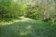
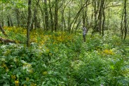
Well, I made it back for a spring-time visit to Rough Creek Watershed on May 20, 2013. It is still just as beautiful as it is in winter, plus the addition of wildflowers and green.
There is a problem though, and I must bring it to your attention.
Because the road bed trails are a soft grassy track, that grass really grows fast in the spring. It grows fast, and tall, and thick, and really a nuisance. The road beds are literally covered with knee high, to thigh high grass that is soaked with dew and tugs at your legs.
Before I left the house I chose to wear hiking shorts for the first time this year. Bad decision. Within the first 10 minutes my legs were soaked from the dew on the tall grass. Thank goodness I had on waterproof hiking boots. Otherwise my feet would have been in the same boat. My brother wasn’t so lucky. He had on conventional hiking boots and had to stop three different times to wring the water out of his socks and insole inserts.
The Cherry Cove Trail was a different problem. It was simply overgrown with weeds, grasses, and wildflowers. While not as tall as the grass on the road bed, the trail was at times difficult to follow because of the overgrowth. Again, with bare legs, I ran into a problem with an allergic rash from one of the ubiquitous weeds that covered the trail.
So chalk this up to a lesson learned. Should I ever hike at Rough Creek Watershed again in the green season, I will be sure to wear waterproof shoes and water-resistant long pants. I highly recommend that you do too.
The watershed is still a beautiful place to hike, but the foliage is very problematic in mid-May.


The following are paid links. As an Amazon Associate I earn from qualifying purchases.
 I am Jeff Clark, founder of Internet Brothers, producer of this blog, and passionate about hiking. I live in Western NC near the Blue Ridge and Great Smoky Mountains. Pisgah and Nantahala National Forests are just out my door, so the content will focus on these areas, but let me know what you would like to see on the site.


Copyright © 2011-2023 Internet Brothers. All Rights Reserved. ISSN 2324-6057
Designed by Elegant Themes | Powered by Wordpress | Logo by Design Aspirations

