
Perhaps you’re looking for a short hike that will really stretch your legs and get your heart pounding. Then you may want to consider the Pressley Cove/Maxwell Cove loop that is not too far from the Pisgah Ranger District headquarters. You’ll climb more than 1,400 feet in just a little over a mile through a beautiful poplar, oak and beech one-age forest. Follow Pressley Creek on the way up, and Maxwell Creek on the way back down, with a stretch on the ridge at the top that offers views of the Blue Ridge Parkway far in the distance. This hike occurred on Thursday, March 7, 2013 from 10:30am to 1:05pm. Our plan was to climb Pressley Cove Trail to its meeting with Forest Road 5002, then return down the Maxwell Cove Trail.
Hike Length: 5.5 miles Hike Duration: 2.5 hours Hike Rating: Difficult, strenuous
Blaze: Orange Elevation Gain: 1,430 feet Hike Configuration: Loop
Trail Condition: Pressley Cove is very good with some creek crossings. Maxwell Cove is an undocumented trail that is not signed, but is easy to follow.
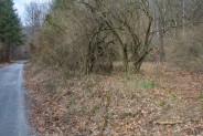
Starting Point: Pressley Cove Trailhead on Forest Service Road 477.
Trail Traffic: We did not encounter any other hikers on this trail.
How to Get There: Leaving the Pisgah District Ranger Station/Visitor Center parking lot near Brevard, NC, turn right (north) onto US 276. Proceed ½ mile and turn right on first gravel road (FS 477, signed for Pisgah Riding Stables). Go approximately 2.0 miles. Look for a small parking area on the left, with the trailhead marker on the right.
Forest Road 477 is also known as Avery Creek Road, or the road where the horse stables are. There are a number of trailheads and campsites along 477, including this short hike up Pressley Cove. Keep your eyes peeled for the trailhead marker on the right side of the road about two miles in. It’s easy to miss. If you reach the stables you have gone too far.
Think of this trail as a connector to many other longer trails that follow the creeks and streams, exploring the gaps and ridges of the Pisgah Ranger District. For example, you can get to Buckhorn Gap and Clawhammer Cove, or if you want to make a full day of it, you can get to the Turkey Pen Gap Trail to South Mills River.
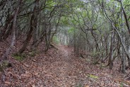
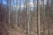
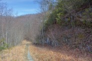
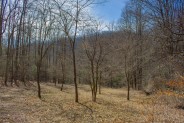
Orange-blazed Pressley Cove Trail starts climbing right away, but at a moderate grade to get your legs and lungs warmed up for what’s to come. The first 2/3 of the hike keeps Pressley Creek on the right side of the trail, passing through several rhododendron thickets as they make a canopy over the trail. The forest is thick with young beech saplings, evidence that this area was heavily logged back in the previous century. Sprinkle in some hemlock and oak, a few poplars and birch, and this a a thick new-growth forest.
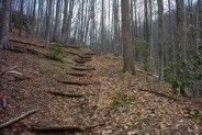
The pitch of the trail gets a little steeper after a quarter mile. The trail builders have put in log stairways to assist with the incline. You can decide for yourself whether the burning in your thighs from the stair climbing is easier than graded terrain with a steady ascent.
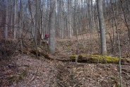
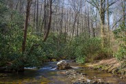
When you reach the first crossing of Pressley Creek is when this hike begins getting really interesting, and strenuous. That first crossing is a three-log bridge with wire mesh over the cracks that’s about 12 feet long. For the rest of the way the trail follows very close to the creek, a narrow ribbon that tumbles steeply down from the mountain above over granite shelves and slabs, creating that beautiful forest sound of rushing water.
And it gets steep. Expect to climb 600 feet in the final 3/8 mile. Take your time. Enjoy your surroundings. Between the silvery creek and the tall stands of tulip poplar, the last third of Pressley Cove Trail is a delight. The forest bed is covered with a thick coat of fallen leaves from autumn seasons past. You’ll encounter more of the log stairways as you climb steeply up, up, up.
You’ll reach a 2nd log crossing, this one back to the west side of Pressley Creek, at a particularly steep section of trail. The creek plunges down a slick black granite slide, while the old rotting log bridge doesn’t look particularly inviting, or safe. It’s just a flash flood from being washed away, and probably has. That may explain the seemingly make-shift condition of the crossing.
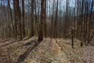
Once safely across there’s another log staircase on the other side that leads to a change in the forest. You’ll notice the trees are taller here, and older. Some of the tulip trees are well-near 100 feet high as they stretch and compete for those nourishing rays of sunshine. You’ll top a crest where the trail flattens for just a bit as you’re walking among tall giants on each side of you.
One final push upward will bring you to the junction with Forest Road 5022. As you approach you’ll see the road bed taking off uphill to the southeast to Pressley Gap and all the other trails that are found up there. But for this hike, my companion and I took a left turn on the forest road.
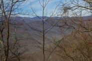
Forest Road 5022 was carved into the side of the very steep south face of Black Mountain. There are thick granite slabs to your right going up the mountain, and a precipitous fall to your left over the edge of the road. In the winter, with leaves off the trees, we caught an occasional glimpse of the snow-lined Blue Ridge Parkway across the Cradle of Forestry valley.
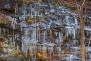
The road is very twisty as it hangs along the ledge below Black Mountain. Rounding one turn we happened upon a long wall of granite that was literally covered in icicles, for perhaps 200 yards or more. Lined up in rows as from a pipe organ, these shimmering crystal daggers were dripping from the warming southeast sun. This has been a mild winter in Western North Carolina. I suspect in years when it gets colder that this layered wall is completely covered in ice.
My friend and I started thinking about lunch, so we found some great logs right where Forest Road 5022 passed over Maxwell Creek. This creek would be our path down the mountain later when we reached the junction with the Maxwell Cove Trail. The creek is right in a hairpin in 5022 where the road takes a decidedly southerly turn. After nourishing ourselves, we continued along the forest road.
It begins a downward trend and makes a couple more hairpin turns before reaching Maxwell Cove. You really have to look closely for this trail on your left. It is not on the Pisgah Forest maps. There is an old wooden sign at the trailhead, but it’s rotting and pelted with buckshot — unreadable. There are no blaze markers on the trees. Just be aware that it is there. Not to fret if you completely miss it though. Forest Road 5022 will eventually take you back to Avery Creek Road.
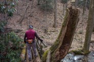
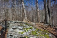
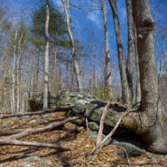
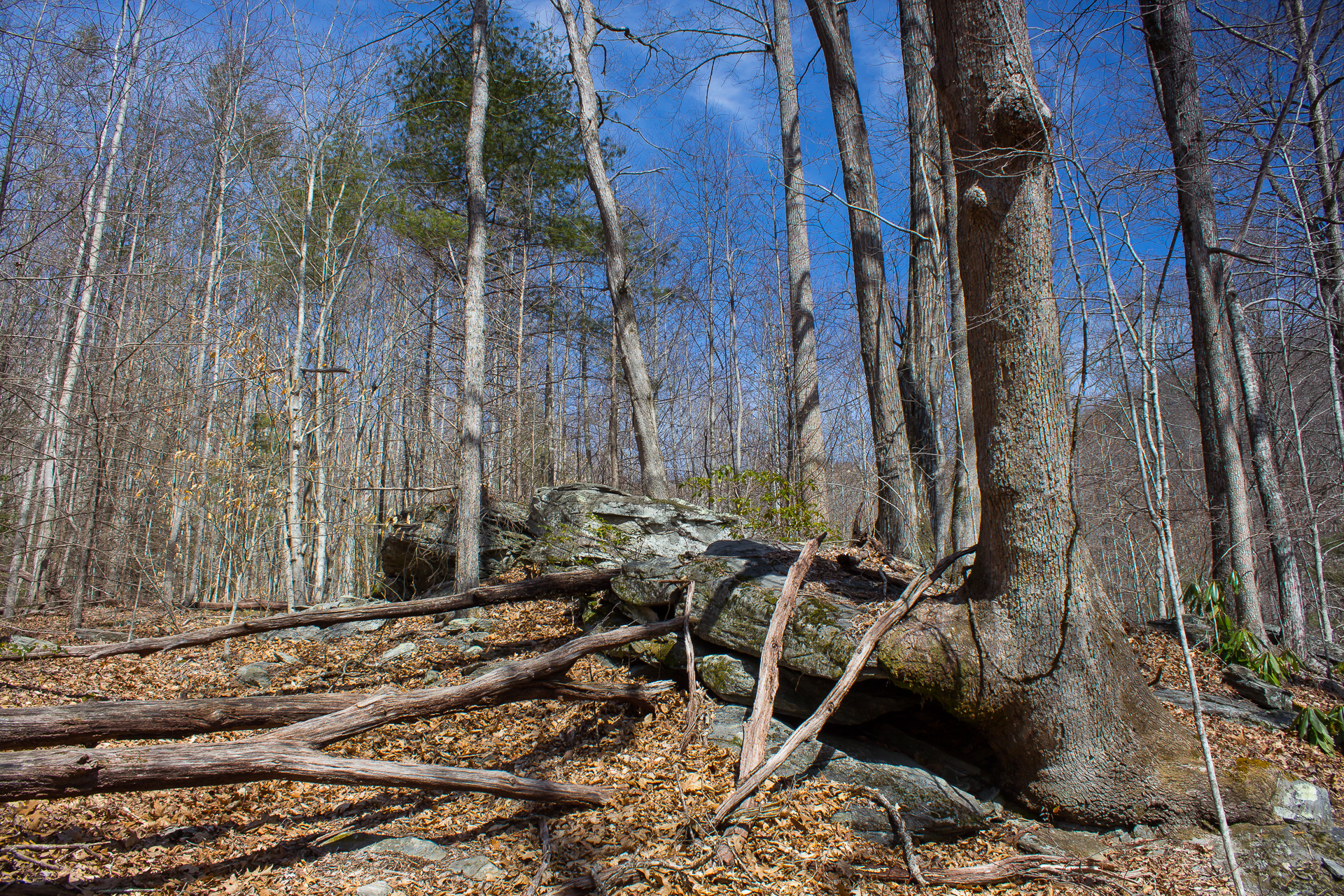
Maxwell Cove Trail begins descending immediately, much like Pressley Cove Trail did on the way up. Not far down the trail, we happened upon a large rock outcropping to our left that was worth exploring. As we got closer, we could see that it was comprised of three very large granite rocks, each of which were surrounded by its own “friend.” Roots of trees were wrapped around the rocks creating a cocoon-like effect. That’s the photo at the top of this post. You can click it for a larger view.
Continuing down, the earth changed to a red clay mixture that wanted to cling to the grids in our hiking boots. Don’t you hate it when that happens? We could hear the sound of rushing water again, so we knew we were getting close to Maxwell Creek.
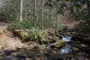
Unlike on Pressley Cove, this trail does not have log bridges over the creek. You are on your own to navigate the crossings. There are two crossings, the first probably 15 feet across. The water was no more than four inches deep, so no worries about flooding the inside of the boots. At least it helped get some of the clay mud off the bottoms. The rocks are moss covered, so watch your step.
We soon came upon a small meadow along the trail with about 6-8 dogwood trees. I imagine this is a delightful sight in late April, in fact I may have to make plans to come back just for that. It’s only about a quarter mile from Avery Creek Road, so I could pop in there for a few photos on my way to another hike.
There’s one last creek crossing before reaching the end of the trail. This one is a little dicier, as the creek has kinda split into channels, one of which is using the trail as a path. So you have to walk through water for about 30 feet. We were fortunate that it was still not deeper than our boot tops, so we managed to get through with dry feet. Just beware that this is there, in case you are hiking after a heavy rain.
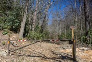
Maxwell Cove Trail ends at a gate on Avery Creek Road that is marked as Forest Road 9999. Again, it does not appear on the Pisgah Forest trail maps. From there, it’s only a few hundred yards back to the Pressley Cove trailhead, and your vehicle.
To summarize, this cove loop is a really good leg stretcher. You will get some great aerobic exercise on the steep sections of Pressley Cove, but won’t be out in the woods all day. The forest and streams are beautiful no matter the season, so if you’ve got 2-3 hours to kill, consider taking the Pressley Cove and Maxwell Cove loop.

The following are paid links. As an Amazon Associate I earn from qualifying purchases.
 I am Jeff Clark, founder of Internet Brothers, producer of this blog, and passionate about hiking. I live in Western NC near the Blue Ridge and Great Smoky Mountains. Pisgah and Nantahala National Forests are just out my door, so the content will focus on these areas, but let me know what you would like to see on the site.


Copyright © 2011-2023 Internet Brothers. All Rights Reserved. ISSN 2324-6057
Designed by Elegant Themes | Powered by Wordpress | Logo by Design Aspirations
