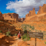
There is a sign at Arches National Park featuring a quote that reads: “Let the people walk.”
It’s a line taken from Ed Abbey’s 1968 nature writing classic “Desert Solitaire.” It might seem like an odd choice: Arches, and its nearest city, Moab, Utah, have become virtually everything “Cactus Ed” hated. The asphalt road ribboning through the park has turned Arches into an epitome of “windshield tourism,” allowing visitors to see nearly every attraction without walking. Once-sleepy Moab has become a hub for “adventure travel,” where outfitters offer mountain biking, zip lining, off-road driving – just about everything except plain old hiking.
But the quote is fitting if taken as an admonition, an interpretation that likely would have suited the curmudgeonly writer, who spent two seasons working as a ranger at Arches. In “Desert Solitaire” and other best-selling books, Abbey championed the untamed spaces, making him the conscience of Moab and a favorite of desert dwellers.
Southeastern Utah has become more developed since Abbey’s era, but visitors can still find ways to enjoy the starkly beautiful red-rock country that sent him into rapture – be it by foot, bike, boat or car. This corner of the state is known for its fantastic rock formations. Moab is also unique in that it has two national parks just outside city limits: Arches and Canyonlands, on opposite sides of U.S. 191 about 10 miles apart.
Arches and Canyonlands represent dramatically different visions of what a national park can be. Canyonlands is less developed than Arches, making it more work to see. But explorers will be rewarded. Hardcore hikers will appreciate Canyonlands while less-active travelers will prefer the easy access of Arches. Any true desert lover should see both.
Hiking Horsetooth Rock is a rite of passage for northern Colorado residents, and it’s especially spectacular at sunrise.
The wind was fairly calm that morning, but it can be gale force – so make sure to have layers with you. There were only four other people up there for sunrise, and no other dogs.
Getting down Horsetooth with a 75-pound dog is much more difficult than getting up. Fit your dog with gear that assists in getting her up and down the rocks. Alma wore a Ruffwear pack that had a handle on the back, which was excellent for hauling her up and steadying her on the way down.
Also consider that your dog should be in fairly good shape for the hike: Alma is a 4-year-old couch potato doodle and she did just fine, but she has youth on her side.
The hike is five miles, round-trip, and it’s fairly steep. You gain 1,441 feet in 2.5 miles, going from 5,815-7,256 feet. There are lots of stairs, ruts and a Class 3 scramble at the end that has some pretty decent exposure on the back side of the mountain. I have a healthy fear of heights, and that was enough to give me some butterflies.
This trail is OK for kids that have their wits about them, but parents should keep a close eye if they are 10 and under: There are several spots you can fall hundreds of feet.
Read about more dog friendly trails in Northern Colorado…
The Green Mountain Club said they listened to member feedback to improve and update their most celebrated publication, without changing the features hikers value.
This is the most complete map of the entire Long Trail system in Vermont. “We are not only excited about the detail of the map but the aesthetics are wonderful as well.”
Still printed on quality waterproof paper, the Long Trail map is durable in all Vermont weather. It increased in size from six to eight folding panels allowing for more detail, including significant Long Trail relocations through the Winooski River Valley and in Smugglers’ Notch.
For hikers looking for a short excursion, thirty-five suggested day hikes and directions to trailheads are highlighted. For those planning to section hike, or hike the whole trail, The Long Trail Map combined with the Long Trail Guide and the End-to-Ender’s Guide provide the most comprehensive resource.
Proceeds of this map and other GMC publications support the work of the Green Mountain Club to protect and maintain Vermont’s hiking trails. The new map can be purchased from the Green Mountain Club website.
Lamping Homestead may be one of the most isolated hikes in Ohio. It is a long ways from anywhere, in rugged southeast Ohio. The 5-mile loop doesn’t cross any roads in the rolling Appalachian foothills between Haney and Pleasant ridges in southwest Monroe County.
It is managed by the U.S. Forest Service as part of the 240,900-acre Wayne National Forest that includes 12 Ohio counties. The national forest lies within an 834,000-acre tract established by Congress in 1934.
The Lamping Homestead Recreation Area is off state Route 537, about two miles from state Route 26. It is about 35 miles from Marietta as the crow flies over the heart of what’s called the Switzerland of Ohio due to the number of Swiss immigrants.
The main trail begins on the other side of a pond and cuts through the picnic area. You will hike through a white pine plantation and into a beech-maple forest. Ravines are numerous. The trail crosses hills, goes down and up in hollows, across ridge lines and along the side of steep hills. The area is heavily wooded with small streams crossing the trail. If the leaves have fallen, you may get glimpses of the Clear Fork of the Little Muskingum River.
Not far away is one of the best backpacking trails in Ohio: the tough 11-mile Archer’s Fork Loop with its massive natural rock bridge. The hike in Washington County includes at least seven climbs of more than 250 feet, crossing between the Ohio River and Little Muskingum watersheds.
More than a month after a Tennessee woman was injured on a solo hike in the Cold Mountain area of a Haywood County, NC, she visited the sheriff’s office yesterday to thank the rescue crews who spent days searching for her.
Julie Hays and her husband Craig personally thanked Sheriff Greg Christopher and others yesterday.
More than 200 people from more than 60 local, state and federal agencies helped search for Julie after she didn’t return from a day hike in late September.
The search continued for two days until she was found injured about 100 yards off a trail in the Lenoir Creek area on Sept. 21, 2015.
“These guys put their lives on hold, they stopped everything that they were doing to save Julie,” Craig Hays said. “It really has changed us because without them, she wouldn’t be here today; she wouldn’t be alive today.”
In spring and summer 2014 Trevor Rasmussen, known also by his trail name Fronkey, used the crowdfunding resource Kickstarter to finance his thru hike of the Pacific Northwest Trail, and to pay for production of a documentary film detailing his adventures. 130 contributors donated a total of $5,262 to his project.
The original Kickstarter requirement was only $1,700, so Rasmussen used the extra contributions to improve his camera equipment inventory, ostensibly to enhance the production quality of the documentary film. In the summer of 2014 Rasmussen and his dog Tala completed the 1,200 mile journey from Glacier National Park in Montana to the most western point of the United States along the Washington coast.
Rasmussen’s Kickstarter pledge was to have his film available to his supporters in April 2015. That time came and went, with no updates from Rasmussen on the status of the project. Spring 2015 passed. Summer 2015 passed. Still no film, and still no communication from Rasmussen to his backers about the status of the project.
The Kickstarter Support team was contacted in October 2015 to make them aware of the negligence exhibited by Rasmussen with this particular project. The support team reached out to Rasmussen and offered their assistance in nudging the project along, and encouraged him to communicate with his sponsors. That has not happened. Still total silence from Rasmussen.
Inquiries via the Kickstarter comments page have gone unanswered. Inquiries on Facebook have been met from Rasmussen by blocking the accounts of those inquiring. Simply put, Rasmussen has chosen to ignore any communications about his Kickstarter project, and leave those who donated their money in the lurch.
It’s a shame too. It leaves a bad taste in the mouths of those 130 who trusted him. It was a tremendous opportunity to give recognition to the beautiful Pacific Northwest Trail and those pioneers like Ron Strickland and Jon Knechtel who made it happen. For those who believe in the system of crowdfunding by fine organizations like Kickstarter, it has been more of a kick in the teeth. Unfortunately, Rasmussen’s inaction makes people less likely to contribute to worthy Kickstarter campaigns in the future. Once burned, twice shy, and all that.
It’s still not too late for Rasmussen to honor his commitment. If anyone reading this happens to know Trevor Rasmussen, I would encourage you to reach out to him and tell him that there are folks out here that are still interested in his project. Just tell him, better late than never.
There is a new section of the Appalachian Trail in Bear Mountain, NY that will open this weekend, thanks to nine months of work by volunteers.
The New York-New Jersey Trail Conference’s Long Distance Trails Crew, an all-volunteer group, contributed more than 3,000 hours this year to relocate a 0.2 mile section of the historic trail in Bear Mountain State Park.
The section was heavily used and deeply eroded, said Chris Reyling of Hartsdale, who’s the head of the Trails Crew team. The relocated route was built with natural stones to minimize erosion, he said. “We hope what we designed is going to last for a long time,” Reyling said.
The Appalachian Trail runs for nearly 2,200 miles from Springer Mountain in Georgia to Mount Katahdin in Maine, passing through 14 states, eight national forests and six national parks.
The Bear Mountain section of the trail was originally built in 1923 by the Trail Conference, and the organization has been working on multiple trail renovation projects in recent years. The opening of the new section will be celebrated with a ribbon-cutting event at noon Saturday, November 14, 2015.
Nothing spoils a good walk in the great outdoors like someone who simply doesn’t know, or doesn’t care, about the rules of the trail. They’re not hard to learn. They’re not overly cumbersome. Most of them aren’t even rules as much as they are fervent suggestions.
Still, when you’re hiking, whether it’s a short day trip on a mile loop in the closest state park or a thru-hike on the Appalachian Trail, you have to know them. You have to know that, for example, blasting Metallica from a wireless Bluetooth speaker strapped to your backpack is not cool. And it’s not because it’s Metallica. It’s you.
You don’t have to be Johnny Backpack to see that many people don’t know the basics, though. Go out on a day hike. Head out on an overnighter. Too often there are too many people mucking it up for others.
Noise, like the guy with Metallica, is one problem that crops up from time to time. But keeping the wilderness clean is a constant challenge, especially for the part-timers out there.
A big key to etiquette on the trail is making sure everyone knows that the outdoors are out there for everybody, not just the guy flicking his cigarette butt or the woman going to the bathroom too close to the stream — and then covering it, toilet paper and all, with a rock.
The trails at Granny’s Acres Conservation Area near Warsaw, Mo., wind through woodlands, up and down steep hills, and across shady valleys cut by small streams. This oak and hickory-dominated woodland is a pretty place for a late autumn or winter walk. The signed hiking loops range from 2.6 to 4.1 miles in length.
“It’s kind of a unique area,” said Jake Willard, department resource forester and area manager. “The trails go way back in and it’s fairly remote.”
Hikers should be aware that the terrain is challenging and rugged in places. They will encounter steep hills. Often loose rock is underfoot on the trails. The rewards are pretty scenery and relative solitude in the woods. Wildlife can be spotted such as deer and armadillos. A variety of birds can be seen in the area.
About 46 acres of glades, open areas with unique plant communities associated with limestone rock, have been restored. A woodland ecosystem is one with open areas between trees with native plants and shrubs.
Granny’s Acres is in a general area of Missouri where historically America’s eastern woodlands met the prairies and intermingled.
Black bears of the Smoky Mountains are starving this fall and their foraging is bringing some of them practically muzzle-to-face with residents and tourists near the most visited national park in the U.S. While bear attacks are rare, officials are concerned and warning people to be careful.
Bears near the park have climbed into cars, ripped open garbage, tried to enter cabins and even chased people. A periodic problem of nature—a collapse of the natural crops of cherries, acorns, hickory nuts and walnuts that bears love to eat—is driving bears out of the park into surrounding areas, said the park’s wildlife biologist Bill Stiver.
The area’s supply of bear nosh is particularly low, probably due in part to random climate factors like late freezes or isolated periods of drought that can impact the trees, he said. Many cubs of the park’s more than 1,500 bears are severely undernourished and their mothers are trying to find food for them, according to biologists, who tracked one bear that walked in the middle of the day through the downtown of Sevierville, Tenn.—about 12 miles from the edge of the national park.
If you encounter a black bear, you should make yourselves “large and loud,” shouting, waving your arms and blowing a whistle if you have one, said Dana Dodd, board president of the Townsend, Tenn.-based Appalachian Bear Rescue, which cares for orphaned or injured black bear cubs until they are healthy enough to return to the wild. “Then back away very slowly. If you run, you can look like prey,” she said. “Everybody with food has to be careful; it’s a desperate situation.”
Biochemistry and microbial biology are majors that require a fair bit of studying. The workload can be stressful. You’ve got to really know your stuff. You can ask Montana State University seniors Colleen Rooney and Emma Sirr. It was after a particularly stressful day during sophomore year that Rooney jokingly suggested to Sirr that the two take off for the West Coast to hike.
The Pacific Northwest National Scenic Trail begins in Olympic National Park at Cape Alava, the westernmost point in the contiguous U.S., and terminates in the high country of Glacier National Park. The trail covers more than 1,200 miles in Washington, Idaho and Montana. It looked like a tangible goal, as did tacking on a leg of the Continental Divide National Scenic Trail, which would allow the hikers to arrive on foot back in Bozeman. Total distance: 1,523 miles.
Rooney and Sirr began planning the trip for the summer of their junior year. They tested ultralight backpacking equipment on a trip to Zion National Park and got out for training hikes between cramming for exams and putting together lab reports. They’d need the same determination they’d mustered for school, and a whole lot more, to complete the route from the West Coast back home.
The amount of foot traffic on the PNT pales in comparison to the number of hikers navigating the Pacific Crest Trail and there’s a relative dearth of information on the former. The trail was first developed in the 1970s, but the PNT wasn’t designated a National Scenic Trail until 2008. The route is still very much in its infancy. Finding information as essential as reliable maps was a challenge.
Even on trails, hiking the right way is sometimes counter-intuitive. Especially this time of year.
Take, for example, a familiar and notorious fall hiking obstacle: the mud puddle. What is the best way to pass?
Toss a big branch over the puddle to create a makeshift bridge to keep your boots from getting muddy? Skirt the edge of the puddle? Walk through the puddle as if it wasn’t there?
“That’s one of the biggest things we tell people when it comes to hiking in the rain,” said Kindra Ramos, spokeswoman for the Washington Trails Association. “Just walk right through. You actually do more damage walking around. “It creates wide spots in the trail. It can damage delicate flora.”
Similarly, tossing branches or rocks over the puddle can change the way water flows on the trail and damage the path. It could also leave a hazard on which others might slip or trip.
Here are some tips that will help keep the trails in good shape…
Watch your step.
A hike in the park could turn into a scuba trip if you walk slow enough in Grüner See, a mountainous Austrian park that turns into a lake every year.
Grüner See, which means “Green Lake” in English, sits at the base of the Hochschwab mountains near the town of Tragoess in Austria, and everything in the park – the benches, grassy knolls, creeks and bridges – become a popular diving spot come spring, when winter’s snow and ice flood the area with beautiful aquamarine water.
By summer, the lake reaches its maximum depth of about 40 feet. The lake’s green color (hence its name) is a result from the grass and foliage that line the bottom of the basin.
We’re getting into prime hiking time, just make sure you don’t take a long nap on one of those benches – you might wake up underwater.
Unless you happen to live there, New Zealand is a long way away from just about everywhere, its distant geographical location for many a barrier to visiting the land of the long white cloud.
Although Google’s Street View has offered couch-based travelers a good chunk of the nation’s jaw-dropping scenery for some time now, most of the content has been limited to the view from New Zealand’s roads having been gathered mainly by Google’s camera-equipped cars.
The good news is that from today you can go well and truly off-road to explore some of the country’s famous “Great Walks,” popular trails lauded for their stunning natural beauty.
“New Zealand’s Great Walks have long been on the bucket list of keen outdoors people from all around the world,” Street View’s Cynthia Wei said in a blog post announcing the new 360-degree imagery. “We hope by bringing the Milford, Kepler, Abel Tasman, Lake Waikaremoana, Heaphy, Routeburn and Rakiura/Stewart Island tracks to Street View, these images will not only help people who are about to trek them prepare, but give anyone who wants to virtually roam the beauty of the Great Walks an opportunity to do so.”
Long hikes through the Grand Canyon are notoriously treacherous. Hikers can suffer heat exhaustion, dehydration, elevation sickness, injury and worse if they haven’t adequately prepared, usually with months of cardio training. So when Kristin Salzman, 44, decided she was going to complete a two-day, 48-mile hike with the non-profit Project Athena, she started training. A lot.
To ready herself for the trek – which would include a 6,000-foot elevation gain and hikes through incredibly steep switchbacks – Salzman worked with a registered nurse and personal trainer for four months. They used an online platform to program Salzman’s rigorous workouts, which included three climbs lasting 45 minutes, an hour-and-a-half and two-and-a-half hours, respectively.
Salzman also did three hikes at an elevation of over 5,000 feet while carrying a backpack that weighed 20 lbs. The longest hike took nine hours. And she rounded out her workouts by kayaking and swimming in the lake in her backyard of Clear Lake, Minnesota, and by circuit training, running and exercising on a trampoline.
The intense training gave her a newfound respect for her body and new priorities when it comes to being healthy. “I used to want to be skinny or hit a certain weight, but now when I go to my circuit-training class, I see my arms, and I’m like, ‘I have muscles!’ You need the strength and the will to go through something like the canyon.”
At the height of training, she was logging almost 20 hours of training a week – and it was grueling. But it also felt like the perfect way to celebrate being breast cancer-free for two years.
Why do we seek out mountains and, in some cases, challenge ourselves against them?
Biologist E.O. Wilson argues that we’re hardwired to feel a special connection with natural systems, something he calls “biophilia.” Because of how we evolved, he says, certain natural settings can be inviting at a deep, biological level. These settings embody the “connections we subconsciously seek with the rest of life,” connections Wilson believes are literally rooted in our blood. For example, Wilson suggests that we are drawn to the African savannah because our species originated there. But this certainly doesn’t explain why mountains—which can be dangerous and forbidding, and often lack life—wield such a visceral effect on us.
Researchers from the University of California, Berkeley, found that awe may be related to good health. Experiencing awe is associated with lower levels of interleukin-6, which is a molecule that encourages inflammation. In other words, more awe is likely associated with less inflammation. Dacher Keltner, senior author on the study, told the New York Times that although awe can be hard to define, one of the emotion’s primary qualities is that it “passes the goosebumps test.”
Could it be that mountains affect us so powerfully because they are big and remind us that we are small? Especially in today’s tumult of Facebook and Twitter and customized newsfeeds and on-demand everything, it is very easy to get lost in our own little worlds—little worlds in which it is easy to feel pretty big. While there is a power to feeling big, there is an equal and perhaps even greater power to feeling small.
Those who make the journey to isolated Jasper National Park are in for a treat — but you’re definitely going to be roughing it here. Located in western Alberta, it is the largest park in the Canadian Rockies, an expansive 4,200 square miles. Despite being significantly larger than its southern-rival Banff (2,500 square miles), Jasper received about 1.5 million less visitors in 2014.
That’s good news for wilderness lovers, especially those looking to disappear for a few days. And Jasper’s flagship backpacking route, the Skyline Trail, is perhaps the most epic way to discover the destination.
The Skyline Trail is 27 miles in length with more than half above treeline. In good weather, it can be completed comfortably in as little as three days, two nights. Many choose to take their time and break the trail down into shorter segments, and one of the best things about the Skyline Trail is that it is designed with such flexibility in mind.
The trail passes through six campsites, each positioned in scenic locations below treeline near or next to flowing water. The amount of campsites and the fact that they are well spaced along the trail allows hikers to choose their own adventure.
You can start the Skyline Trail from either the Signal or Maligne Lake trailheads. It is recommended starting from Signal because you get the most boring part of the trail, a fire road with no views, out of the way in the beginning as opposed to letting it be an anticlimactic end.
It was a busy summer on the Appalachian Trail. The movie “A Walk in the Woods” made its debut, the path received national attention for a perceived party culture and the well-known endurance athlete Scott Jurek set an overall record on the trail.
Then, quietly and relatively unnoticed, a woman named Heather Anderson hiked the trail by herself, averaging more than 40 miles a day. In doing so, she set the trail’s self-supported speed record.
There are two types of Appalachian Trail speed records: supported and self-supported. A supported record allows an athlete to travel with companions and resupply at road crossings using a crew. The self-supported endeavor demands that the individual walk unassisted, without emotional support on the trail or physical support at blacktop intersections and towns.
Records on long-distance trails are akin to cougar sightings on the East Coast: rare, controversial and hard to verify. Although these endurance records, recently titled Fastest Known Times, or F.K.T.s, have been recorded on paths like the Appalachian Trail since the 1970s, there is no governing body to officiate or authenticate them. They are based on an honor system in which one’s word is generally accepted even if the feat itself is criticized. There seem to be just as many people who will belittle and berate an F.K.T. for being too fast as who will be in awe of such a raw display of endurance.
 I am Jeff Clark, founder of Internet Brothers, producer of this blog, and passionate about hiking. I live in Western NC near the Blue Ridge and Great Smoky Mountains. Pisgah and Nantahala National Forests are just out my door, so the content will focus on these areas, but let me know what you would like to see on the site.


Copyright © 2011-2023 Internet Brothers. All Rights Reserved. ISSN 2324-6057
Designed by Elegant Themes | Powered by Wordpress | Logo by Design Aspirations