Pilot Mountain State Park’s newest trail – a 4.5-mile loop near the base of the mountain – was inspired by a firebreak hastily constructed with a bulldozer in 2012 and recently completed by park staff and volunteers from Friends of Sauratown Mountains.
The Mountain Trail rambles around the slopes at about 1,500 feet elevation, at one point connecting with the Grindstone Trail near the park’s campground and also accessible from near the visitor center and from a remote parking area on Pinnacle Hotel Road (aka Surry Line Road) that serves as a trailhead for the Corridor Trail. Park Superintendent Matt Windsor said that remote trailhead is the best way to get onto the trail when the park is crowded.
Windsor said the composition of the surrounding forest subtly changes as a hiker makes the circuit, and in winter, the trail offers impressive views of the summit knob.
A 2012 prescribed burn that briefly escaped control prompted the N.C. Forest Service to construct a firebreak around the mountain’s base. Although the firebreak was never really tested by the blaze, parks system officials considered it as a potential trail. Though much of the bulldozed route was found to be too rocky and unstable for a trail, the idea persisted. Most of the new Mountain Trail was routed slightly farther uphill, though a few sections of the bulldozed path were used.
The creation of the Parque Patagonia conservation area – the brainchild of a billionaire US couple – is a step to creating one of the world’s largest national parks. But what’s the hiking like?
“Pain?” asks Jorge Molina, my hiking guide. Yes, there is a little pain, but it’s too late for cold feet. Or, more accurately, it’s too late not to get cold feet, because we’re already shin-deep in a swift icy river.
“We’ll cross 20 of these rivers today,” Jorge warns. I won’t complain. These cold rivers, flowing down from the glaciers and mountains of Lago Jeinimeni national reserve in Chile’s Aysén region, will supply drinking water on our four-day trek into Parque Patagonia. And things could be far worse. “Sometimes these rivers come up to the waist,” says Jorge. Parts of my body are thankful the water isn’t that high now.
There has also been a little pain in the birth of this new park – which opened fully this year, and may soon become a major new national park. American billionaire Doug Tompkins (founder of the North Face and Esprit clothing brands) and his wife Kristine (former CEO of clothing company Patagonia) have been working on it for years. The ambitious plan was to unite land they bought in the Chacabuco valley in 2004 with the neighbouring Jeinimeni and Tamango national reserves, to create a 650,000-acre public access park. They hope it will get national park status in 2016, though it could take longer.
Great Smoky Mountains National Park wildlife biologists remind the public to allow bears to forage undisturbed on natural foods during this critical feeding period before winter hibernation. Bears depend on Fall foods such as acorns and grapes to store fat reserves that enable them to survive winter. This year, these foods in the park are extremely rare leading bears to move long distances in search of food.
Many bears have been reported well outside the park boundary including several sightings in busy, downtown communities and neighborhoods. Recently, a mother bear with a GPS-monitoring collar and three cubs traveled over 20 miles from the Elkmont area of the park to downtown Sevierville, TN. Local residents are reminded to keep residential garbage secured and to remove any other attractants such as bird feeders and pet foods.
In addition to greater movement in search of food, bears are also foraging on less-desirable mast such as hickories and walnuts. Park staff have reported as many as eight different bears visiting a single hickory tree to feed on nuts. Photographers are reminded to use telephoto lenses to capture photographs and to remain at least 50 yards from bears at all times.
“There were no cherries this year and the hard mast is marginal at best,” said Smokies Wildlife Biologist Bill Stiver. “Because food is scarce, bears are trying to access individual trees in areas they normally would not during good food years.”
Feeding bears is illegal and all food waste should be properly disposed of to discourage bears from approaching people. Feeding, touching, disturbing, and willfully approaching wildlife within 50 yards (150 feet), or any distance that disturbs or displaces wildlife, is illegal in the park. If approached by a bear, visitors should slowly back away to put distance between the animal and themselves creating space for the animal to pass.
For more information on what to do if you encounter a bear while hiking, please visit the park website. To report a bear incident, please call 865-436-1230.
Here’s a good reason to go outdoors this weekend.
Earlier this month, Goran Olsen was on a hike in the Norwegian village of Haukeli when he caught sight of a 30-inch object under some rocks. It turned out to be a 1,265-year-old, wrought iron Viking sword.
The artifact is believed to be from A.D. 750, Norway’s Hordaland County Office said. It’s in unusually good condition, with a bit of rust on the surface that accumulated after being buried under frost and snow for centuries.
The sword is now safe with the University Museum of Bergen, whose researchers will preserve it and begin a research expedition in Haukeli in spring 2016 – after the winter snow melts. The University thanked Olsen for helping the researchers discover more about the country’s history.
Glacial melt driven by climate change is leading to more archaeological discoveries. In 2011, scientists discovered a pre-Viking-era tunic, believed to date back to A.D. 300, near a thawing glacier in south Norway. In September 2013, scientists also found the remains of a horse from the Iron Age in a melted glacier in Oppland County, Norway. In the summer of 2014, some 400 objects resurfaced after deeper layers of glaciers and ice sheets in Oppland County melted.
Bob Marshall hiked 288 miles over eight days through the northwestern Montana wilderness in 1928. Marshall would average 36 miles a day during the epic hike, and The Bob Marshall Wilderness would officially be created 36 years later, after Marshall.
“Averaged,” says Chris Peterson of Marshall’s daily walks. “I averaged 10, and I didn’t bag the peaks he did.”
In 2014, 86 years after Marshall’s journey, Peterson retraced Marshall’s large footsteps, with a few modifications, through the Swan Range, The Bob Marshall and Mission Mountains, traveling about 200 miles in 20 days. Peterson, admittedly a slow hiker, didn’t move as quickly as the fleet-footed Marshall, and he was lugging enough camera gear to “choke an elephant.”
But he returned with incredible wilderness and wildlife photographs and material for a book he would call, “A Walk on the Wild Side.”
Marshall, the co-founder of the Wilderness Society, was an early crusader for wilderness protections. The Bob Marshall Wilderness is named after him. He was 28 years old when he made the trip through what would become the Bob and areas surrounding it.
An interactive, innovative documentary where Greece’s countryside, hiking trails and culture meet Google technology is on the way, according to Stelios Mavrodontis, production manager and head of the four-member team E4.
Two years ago, Google launched its Trekker loan program, which enables explorers to borrow a special backpack mounted kit which includes the same camera device found on Google Street View vehicles. This offers tourism boards, nonprofit organizations, research organizations, universities and others the opportunity to collect imagery from hard-to-reach places while assisting Google in its efforts to provide panoramic views from ground level of as many global locations as possible.
Greece was the 56th country to join the Google Street View project, in June 2014. The goal is for Google to give its users the chance to see places of historical and cultural significance all over the world as if they were there themselves. For the time being, three Greek destinations have been mapped out via Trekker, and now the Meteora monastery complex, the Balos Lagoon on Crete and the Samaria Gorge, also on Crete, are available for users to visit online.
Using Google Trekker, the team will be able to offer an inspirational, three-dimensional tour of Greece’s hidden natural treasures and, as a result, viewers of the documentary will be able to virtually interact with the environment.
The Rivanna Trail is bounded by the Rivanna River, two of its tributaries (Meadow and Moore’s Creeks), and a small undeveloped mountain called Observatory Hill. The twenty-mile rustic footpath meanders through the natural greenbelt that surrounds the City of Charlottesville. The area provides a scenic opportunity for hiking, and residents and visitors alike can quickly and easily leave behind the stresses of modern city life. The trail is unique in that it is truly an urban wilderness trail.
The Rivanna Trail is a well-used well-loved urban treasure. It was built and is maintained entirely by community volunteers. The Trail passes through six City parks; connects neighborhoods and schools; skirts community garden plots; lies within reach of restaurants, hotels, and medical facilities; takes hikers safely under busy roads through culverts; traverses University of Virginia land; and provides hikers with views of historic mills and dams.
The community highly values the opportunity to have a wilderness experience right outside their doorsteps. Within minutes, a hiker can reach a place where he hears only the sounds of nature: rushing water, wind in the trees, birds— no cars or machines.
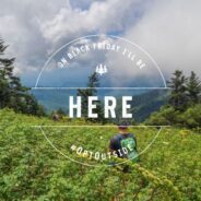
Outdoor gear and sporting goods retailer REI is canceling Black Friday this year. No promotions, no hourly sales, no doorbusters, no waiting in line.
In an unprecedented move for the modern-day holiday shopping season, REI’s 143 stores will be closed the day after Thanksgiving. The co-op business plans to launch a campaign Tuesday encouraging people to forgo shopping to spend time outside instead. With the hashtag #OptOutside, REI will ask people to share what they’re doing on Black Friday on social media.
REI is taking direct aim at the frenzied consumerism that dominates the holidays with a message to do the exact opposite of what Black Friday demands.
“Any retailer that hears this will be startled by the idea,” says REI President and CEO Jerry Stritzke, who admits he was apprehensive about closing at first. “As a co-op … we define success a little differently. It’s much broader than just money. How effectively do we get people outside?”
REI is hoping to convince consumers to start a new Black Friday tradition, one that doesn’t involve buying anything. It has built a dedicated #OptOutside website with resources on local hiking trails. REI’s campaign was built with its employees and customers in mind — the company operates as a co-op, with roughly 5.5 million members who pay a one-time fee for a share of the business. Members contribute to at least 80% of REI’s sales.
One second you are bushwhacking through thickets of bamboo in Rwanda’s Volcanoes National Park, pulling yourself up a steep lava slope, toehold to toehold. The next, you turn a corner and sunlight streams through the canopy to illuminate a matted clump of black against a curtain of rain forest green. You’ve known this was coming and still you gasp. Seated perhaps 30 feet away is one of the roughly 900 mountain gorillas remaining on earth, a saggy-breasted female, and soon you see that she is cradling an infant in her lap. She wraps one arm around the 6-month-old while scratching her own ear with an extended index finger.
She is the advanced sentry for the Hirwa family, a clan of 20, and to the extent that she seems to care at all about our arrival, her attitude smacks of “What took you so long?”
Any anthropomorphism must be forgiven; it is impossible not to be struck by the humanoid nature of these neighbors on the evolutionary chain. While observing so much of African wildlife — warthogs, elephants, giraffes — one marvels at their prehistoric form and questions our placement in the same biological class. With the mountain gorillas of Rwanda, which share 98 percent of our DNA, we are looking into a mirror, and they are looking impassively back.
Thirty-five years ago, the Virunga population had been thinned by poaching, disease and habitat loss to an extremely endangered 250. Conservation efforts have brought the count gradually back to 480, with about 300 of those on the mountainsides of Volcanoes National Park. There were 31 births there from June 2014 to August 2015 (after a gestation, not surprisingly, of about nine months).
A large rockfall recently closed state Route 9 in Zion National Park, prompting a look back at the worst rockfalls and landslides in the park’s history. The most recent rockfall occurred Wednesday, Sept. 23, 2015 and closed state Route 9 near the Pine Creek Bridge on a switchback near the Mount Carmel Tunnel, according to Zion National Park officials. The largest boulder in the fall measured around 19 feet high, 20 feet long and 15 feet wide and weighed 200 tons.
While September’s rockfall didn’t cause any fatalities or significant damage to buildings, that hasn’t always been the case with rockfalls in the park. Zion National Park has a long history of large landslides and falling rocks due to the tall cliffs and exceptional rate of erosion, park officials said.
“To get a feel for the frequency of small rockfalls, it has been my observation that there is at least one new rock in park roads or the roadside ditches almost every day,” Zion National Park spokeswoman Aly Baltrus said. “When in Zion Canyon or the backcountry hearing the clack, boom or clatter of a small rockfall is an almost daily occurrence. When it is raining, the frequency reaches a few per hour.”
Baltrus said although there have been some fatalities in the park’s history due to falling rocks, the number is relatively low due to the fact that visitors spend a relatively brief period of time in high rockfall hazard areas, like the immediate base of cliffs. My brother and I can relate, as we heard, and saw the cloud of dust of a rock fall while hiking to Scout Lookout.
The Urubamba River rattles and hums like the sound of its own name as we begin the four-day hike. With porters to carry the heavier gear on the mountainous 43km track, our group spreads out along the trail, ducking through forests and crossing alpine pastures. Above us, the 5860m peak of La Veronica keeps watch like a silent, snow-veiled nun.
Quechua Indians skim past, seemingly unburdened by the huge bundles they carry. We reach our first set of ruins, Patallacta, with its unmistakable pillow masonry, then keep climbing until our first campsite, Wayllabamba village, at 3000m, comes into welcome view.
Day two is the big one. We start early, heading ever upwards. Behind us, the valley is a wedge of air driven into the earth while the spires of the Cordillera Vilcabamba loom above us. It’s exhilarating, breathless work but after three hours we reach the dramatic Abra de Huarmihuanusca, “Dead Woman’s Pass.” At 4420m, this is the highest point of the trail.
After a good night’s sleep we hoof it up to Runkurakay, a lonely fort that has guarded the Inca Trail for half a millennium. Its mortarless stones still dovetail so perfectly that you can’t slip a piece of paper between them.
Fantastic twists of vapour sweep up from the valley floor as we attack a short, steep incline to the next pass at 4000m. The descent is literally historic — we’re now on the original stones of the Inca Trail, walking in the footsteps of messengers from across the Incas’ vast empire.
Have you been invited on yet another hike to an incredible peak? Make this the last time that ever happens by following this handy guide.
Your hiking party doesn’t know how lucky they are that they invited you along, so be sure to remind them whenever there’s a lull in the conversation. You spent an entire weekend on the Pacific Crest Trail back in 2002, and have since skimmed through three guidebooks on native plants.
Make sure you tell everyone the proper way to adjust his or her hiking poles. Oh, and don’t forget to remind them of that time you met Bear Grylls at the In-N-Out Burger.
Hiking is a great way to get rid of the food that you don’t like. Nothing satisfies intense mid-hike hunger like kale chips, right? Bring plenty of healthy food so you can show your trail party how health-conscious you are. When your stomach starts grumbling and you feel faint, you can always ask for half of your friend’s tuna sandwich and Snickers bar. He won’t mind.
There’s nothing your friends would rather listen to than your complaints; detail the type and intensity of your pain every 10 yards or so, and stop to rub your sores for extra effect. Bonus points if you refuse pain medication or bandages. Sigh often.
As October shoulders its way into November, the cool sunny days can easily lull us into a sense of comfortable complacency. Hikers call this time of year the “shoulder season,” when the golden days of fall are gone, but full-blown winter isn’t quite here.
Most people try to forget about the coming cold, snow, and wind, but the advance of seasons has already begun in the mountains. Everyone enjoys the gift of a mild October or early November day, but rest assured, winter has already begun to lay its icy foundation.
When planning a day in the woods, consider that the ambient temperature when it’s clear is almost 5.5 degrees colder for every 1,000 feet of elevation change. If the weather forecast predicts a high of 42 degrees near where you live at an elevation of 300 feet, then it will be 31 degrees in the woods where you hike at 2,300 feet. The wet rocks, streams or the previous thaw will now be ice.
By mid-October it’s time to hang up the summer daypack and start carrying the more commodious “beast,” filling it with “twos:” two, two pairs of gloves, two fleeces and the extra contingency stuff of winter.
The lightweight rain shell is put away, replaced by a warmer, heavier soft shell. Two water bottles migrate to the pack, replacing the hydration system whose hose freezes in cold temperatures. The water bottles should be in insulated koozies or wrapped in clothing to keep them from getting too cold. The foam pad that cushioned the summer lunch breaks now insulates and keeps you warm.
Society is full of rules. As grownups, we all know not to talk with our mouths full and to always face forward in a crowded elevator. But there was a time when we were young and inexperienced and maybe a little unsure of how to behave.
Let’s face it, we’ve all either been that kid (or shared space with that kid) who sneezed without covering his mouth or stared at someone for way too long. Somewhere along the way, someone shed some light on our less than welcome behavior — and we are all the better for it.
If the thought of hiking etiquette makes you feel like that uninformed kid, here are five simple things to keep in mind the next time you hit the trails.
AussieHikingTours.com is an online booking site for nature-based walking tours.
Not just full pack-carry multi-day treks, but also more luxurious accommodated holidays with day-hikes most days, single day hikes, half-day hikes, vehicle tours with a significant nature walking element, and everything in between.
There are even day tours where you’ll have the opportunity to hike as well as kayak or bike ride.
There are currently 51 tours, but new ones will be added every week and the current selection is well representative of what Australia has to offer. Soon, there will be self-guided options where gear, food and trip notes are provided for you as well. The plan is to cover every option for the traveler who prefers their holidays to be spent in Nature.
AussieHikingTours.com is the brainchild of Neil Fahey, award-winning Australian hiking blogger extraordinaire. Neil has been planning and developing this project for quite some time now, and he is very excited to be able to announce its availability to those of us who like to find the best trail opportunities all over the world.
Since 1985 Wallowa LLamas has led hikers into the rugged Wallowa Mountains, nicknamed the Oregon Alps, where one of the highest peaks (9,826 feet) is, in fact, called Matterhorn.
A llama trek isn’t like a pack trip with horses, where some horses carry riders while others carry tents and stoves. You don’t ride llamas, you hike along with them. The advantage to a llama trek is that these tough, intelligent, good-natured (for the most part) and sure-footed beasts carry the gear and food. They can navigate steep and narrow trails high into the wilderness while all you carry is a day pack.
Unlike horses, llamas don’t wear metal shoes that can tear up trails; a llama’s soft but tough foot pad — a bit like a dog’s — leaves less mark on a trail than a hiker’s lug-soled boot. And at the end of the day they graze in a meadow like deer, with no need to pack in special feed that might bring weeds.
So you get a load-free, low-impact hike into the backcountry, with the bonus of getting to know llamas. And they do have personalities.
Each guest can bring 20 pounds of gear to be carried by llamas. That includes your own sleeping bag, pad and clothing. The outfitter provides tents, meals and cooking gear. Balancing packs for the llamas is an art involving a handheld digital scale. Llamas carrying guests’ gear are fitted with nylon packs mounted on a special saddle, balanced at 28 pounds per side. Larger, stronger llamas carry big plastic coolers or custom-made metal cargo bins.
Nearly one-third of the New York City’s land is carved out for parks, playgrounds and recreation facilities — so there’s plenty of room to find fresh air.
And for those who love the outdoors, there are plenty of trails to hike for peak fall foliage season, which spans a couple of weeks starting around mid-October.
“Mark your calendars to hit the trails, burn off your Halloween candy and Thanksgiving turkeys,” Sarah Aucoin, NYC Parks’ Director of Urban Park Rangers said in a statement.
“Stay active and healthy while catching glimpses of some of New York City’s hundreds of species of wildlife.”
Here are the top five hiking trails in the city, according to the New York City Department of Parks and Recreation…
With a hiking pole in one hand and pruning shears in the other, Ron Dobra picked his way along the Appalachian Trail, snipping overhanging branches and making note of eroding soil. For the past 20 some odd years, he has helped maintain the popular hiking trail, which spans from Georgia to Maine and is seeing more foot traffic each year.
“The entire length of the AT — 2,200 miles — even though it’s a national park, is maintained and kept open entirely by volunteers,” Dobra, 68, of Greenville, said. “So without volunteers there’d be no Appalachian Trail.”
The vast majority of Appalachian Trail in Maine — 267 miles of 282 miles — is maintained by volunteers of the Maine Appalachian Trail Club. Each MATC maintainer is assigned a small section of the trail, usually 2 to 4 miles long, and is responsible for keeping that section in good condition.
In recent years, despite the increasing popularity of the AT, the club has struggled to find enough maintainers to cover every section of the trail in Maine.
“I was told that once upon a time … there was a waiting list for people who wanted to be section maintainers,” Dobra said. “You couldn’t just walk in and get one. You had to be put on a waiting list. Well, that’s not the case anymore.”
 I am Jeff Clark, founder of Internet Brothers, producer of this blog, and passionate about hiking. I live in Western NC near the Blue Ridge and Great Smoky Mountains. Pisgah and Nantahala National Forests are just out my door, so the content will focus on these areas, but let me know what you would like to see on the site.


Copyright © 2011-2023 Internet Brothers. All Rights Reserved. ISSN 2324-6057
Designed by Elegant Themes | Powered by Wordpress | Logo by Design Aspirations