Stretching over five miles from its furthest tributaries in the Staten Island Greenbelt to its mouth in Fresh Kills, Richmond Creek flows through many layers of hidden history. Its waters pass by toxic landfills and old mill remnants, a historic town museum, a manmade mountain of rubble, a vast Boy Scout camp, and an abandoned tuberculosis hospital.
Along its entire course, the creek is a fascinating blend of natural and engineered landscapes, simultaneously operating as a stormwater drainage system and a wildlife sanctuary for several rare aquatic species. Staten Island’s only population of northern two-lined salamander live along its banks, while its waters host New York City’s only population of blacknose dace and the first beavers to appear in the city in over 100 years.
Wandering through Richmond Creek’s teeming ecosystems today, it is surprising to consider that just 20 years ago, this was one of New York City’s most contaminated waterways, polluted by raw sewage from backed-up septic systems.
“Bacterially speaking, it was just horrific,” says Robert Brauman, the construction project manager for the Staten Island Bluebelt, which began working to improve the creek in the 1990s. “Parts of it were almost like an open sewer, and you could smell the urine.”
Although the scars from centuries of human interference are still readily apparent all along Richmond Creek, it has now been transformed into one of the most pristine waterways in New York City, thanks in part to the Department of Environmental Protection’s (DEP) unique Bluebelt program, which brought a new sewage system to the area.
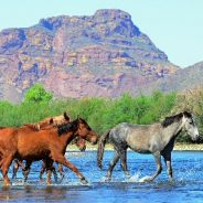
The Sonoran Desert Trail System in Arizona’s Tonto National Forest has more than 20 miles of interconnected paths between Usery Pass Road and Bush Highway just south of the Salt River Recreation Area. The northernmost route in the system is the Wild Horse Trail, which is also part of the Valley-circumnavigating Maricopa Trail. As its name suggests, the trail passes through the domain of wild horses.
The elegant and sometimes controversial beasts can be spotted wading in the river, poking around in the riparian corridors and grazing in the surrounding foothills. Regardless of where you might see them, it’s smart to keep your distance and enjoy the herds from afar.
The Wild Horse/Maricopa Trail escapes the din of the crowds and is high enough in the hills to afford inspiring vistas of the Salt River valley, Four Peaks, Red Mountain and the Usery Mountains.
Starting from the trailhead on Usery Pass Road, the trail starts out through wide washes and scoured gullies. You’ll cross an old pit where rusting bullet casings, broken glass and other relics of target-shooting activities remain in the sandy, buffered depression.
The green band of the Salt River snakes through a chiseled landscape to the north, then arches south where it wends around Red Mountain in the Granite Reef Dam area.
Hikers can make a New Year’s resolution for adventure when the Swannanoa Valley Museum’s annual hiking series resumes in 2018. The museum offers two hiking programs, the challenging Swannanoa Rim Hike Series and the more moderate Valley History Explorer Series.
The Rim Hike Series explores the peaks of the Swannanoa Valley, while the Valley History Explorer Series revisits the past of local communities across the valley. Prospective hikers can learn about the programs at three free informational meetings.
The first will be at the museum on Tuesday, Jan. 9, 2018 at 6:30 p.m. The second will be at REI Asheville on Wednesday, Jan. 10 at 7 p.m. The third will be held at Black Dome Mountain Sports in Asheville on Thursday, Jan. 11 at 7 p.m.
Now in its ninth year, the popular Rim Hike series consists of 11 hikes that reveal the history and geography of the Swannanoa Valley. The hikes explore a different section of the 31-mile-long Swannanoa Rim, terrain that spans from Jesse’s High Tip, across Lakey Gap, over Ridgecrest and Montreat, up to the Blue Ridge Parkway and down to Cedar Cliff above Camp Rockmont.
The hikes take place every third Saturday from January to November. Participants register in advance and meet at the museum (223 W. State St., Black Mountain, NC) to depart at 8 a.m. The hikes are led by veteran hikers who share their knowledge about the history, topography and ownership of the land. Each hike ranges from three to eight miles over elevations ranging from 2,316 to 6,462 feet.
Great Smoky Mountains National Park announces the 41st annual Festival of Christmas Past celebration scheduled on Saturday, December 9, 2017 from 9:30 a.m. to 3:00 p.m. at Sugarlands Visitor Center near Gatlinburg, TN. The event, sponsored in cooperation with Great Smoky Mountains Association, is free to the public.
The festival will include old-time mountain music, traditional shape note singing, mountain craft demonstrations, and a living history walk. Visitors can also experience these traditions through hands-on activities such as make-and-take craft stations. Hot apple cider will also be served throughout the day.
“Around Christmas time, people gathered in churches, homes, and schools where they celebrated the holiday through music, storytelling, and crafts,” said North District Resource Education Supervisor Stephanie Sutton. “The Festival of Christmas Past allows us to pause and remember some of these traditions.”
The popular Christmas Memories Walk will be held at 11:00 a.m. Costumed interpreters will lead a short walk from the visitor center and talk about life in the mountains during the holidays. Through this living history program, visitors will experience the spirit of the season in the mountains during the early days.
The full schedule of events at Sugarlands Visitor Center includes:
9:30 Shape Note Singing
11:00 Old-time mountain music with Lost Mill
11:00 Memories Walk
12:00 Old-time mountain music with Boogertown Gap
1:00 Smoky Mountain Historical Society
2:00 Appalachian Christmas Music and Storytelling – NPS Staff
After eight months and more than 500 comments from Oregonians, the U.S. Forest Service is closing in on a proposal that could protect central Oregon’s most scenic areas from overuse.
The Forest Service kicked off the project in the spring by holding public meetings to gauge interest in changing the way trails and campgrounds in five popular wilderness areas, spanning up to 530,000 acres in the Deschutes and Willamette national forests, are managed. Today, officials are optimistic a decision for the project — known as the Central Cascade Wilderness Strategies Project — will be released by summer.
According to a document released in May, visitation to the five most-used trails in the Three Sisters Wilderness Area increased by between 249 and 878 percent between 1991 and 2016. The increase has led to additional trash, tree damage and soil erosion in the wilderness areas.
At the end of May, the Forest Service released a proposal for the affected wilderness areas, which discussed creating a limited entry permit system for certain day-use areas and all overnight campers in wilderness areas, along with imposing restrictions on campfires above certain elevations.
The Forest Service will incorporate public comment to come up with specific alternatives, and draft an environmental assessment by next spring. A separate, parallel public planning process, focused on the logistics of a fee and permit structure in wilderness areas, will begin in the spring of 2018.
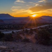
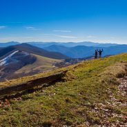
Have you ever spent several pre-dawn hours climbing to the summit of a mountain so that you can get the best angle to see the sunrise?
Some people will go to great lengths to witness the daily dramas of sunrise and sunset. It’s not just about watching the big yellow ball appear or disappear over the horizon, but about the surrounding landscapes and clouds at the same time.
A handful of the most dramatic dawn and dusk destinations are inside U.S. national parks.
Some sun-viewing spots are well known and filled with photographers each morning and evening. Others are remote and difficult to access, so you’ll have to share the panoramas with only a few intrepid hikers.
Here are some great places to watch the sunrise or sunset in U.S. national parks…
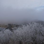
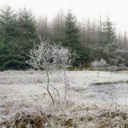
Many casual outdoor enthusiasts simply hang up their boots at the first sign of frost.
“Many people think that when the cold comes, hiking season is over, but that’s definitely not the case,” says a backcountry guide.
“In the winter, trails are less crowded, and there are views that you’ll never see during the summer.” Imagine trekking through a giant snow globe with fields of white-dusted Douglas firs and silence so deep it warms your soul. It’s like that.
You might be surprised to learn that winter hiking takes just slightly more planning than the warm-weather version. “Keep in mind that the days are much shorter in the winter,” says the guide.
“If you’re doing a longer hike, it’s a good idea to start as the sun is rising to give yourself plenty of time to finish before nightfall.” And factor in the change to your usual terrain: “You may cover two miles an hour on a summer hike, but don’t be surprised if that speed is cut in half—or more—in wintry conditions,” he says.
Always share your route and ETA with someone in civilization. As for dressing the part, start with a sweat-wicking base layer, followed by one or two layers of wool or fleece insulation with a waterproof outer shell.
Cold temperatures mean hiking trails are not only less peopled but also bug-free.
Here are other reasons why winter will be your new favorite hiking season…
The Meyers fire didn’t get a lot of press this summer, but it won’t go unnoticed among fans of the Anaconda-Pintler Wilderness.
As it blackened about 62,000 acres of the Beaverhead-Deerlodge National Forest near Philipsburg, Montana, it made some particularly vigorous runs through the Pintler Ranger District. Even before the flames died, U.S. Forest Service backcountry workers started inventorying the damage to their trails and campsites.
Their to-do list showed 40 miles of trail covered with downfall, burned bridges and erosion trouble. The Wisdom/Wise River Ranger District has another 10 miles that is burn-damaged. And the Bitterroot side has 20 miles of work — all in a wilderness area that has only 250 miles of trail across all three ranger districts of west-central Montana.
The Wilderness Act of 1964 prohibits use of mechanized equipment in wilderness areas, so any repair work by law must be done with traditional, hand-powered methods. That meant crosscut saws, axes and mules.
A 20-person crew set out on the last week of September, just when the weather went from fire season to rain and snow.
“We put in a whole summer’s worth of work in four weeks,” the crew lead said. “They took out 450 burned snags felled with crosscuts or axes. There were 1,250 downed trees cut out of the trails. That puts us ahead for next year, but we still have at least as many that we didn’t get to.”
November marks the ten-year anniversary of the inaugural hike of Vancouver Island’s North Coast Trail at Cape Scott Park.
5,239 hikers have hiked the North Coast Trail since it opened to the public. Compare that to the average 6,000 people that hike the West Coast Trail each summer and you’ll understand why hikers come to the NCT from far and wide for it’s wild, untouched feel.
A visit to the Cape Scott Lighthouse is generally a triumphant moment for hikers of the trail who want to check off a visit to the most Westerly point of Vancouver Island.
The trail was built by crews who worked long shifts, slept in tents and had very few amenities. Early on the construction crew decided they wanted to build the trail without any electricity, not even generators. So, everyone got very comfortable with chainsaws and candles.
Cape Sutil has the glory of calling itself the northernmost point of Vancouver Island. It is a favorite for visitors who love to stop for panoramic view on the trail.
It took over 4 years to build the North Coast Trail, with many delays due to rerouting because of sensitive ecological areas. Species at risk in the area, like the red-legged frog, also prompted some reimagining of the originally planned route.
Lets Walk is an iOS application specially designed for tracking walks and hikes.
So far over 50k users from all around the world are using this, and they are growing very rapidly each month. Soon, they will be adding social features such as creating hiking groups, sharing hike experiences, recommending trails and reading hiking blogs within the app.
Lets Walk is accurate tracking your steps. Lets Walk uses Moves API to access your walking activity and track all your steps, distance, time and calories.
Lets Walk can improve your daily exercise and fitness goals. You are encouraged to setup goals and walk more frequently. Increase in exercise can lead to better health & lifestyle.
You can invite your friends to share walking data, keep progress and weekly rankings. Easily post your walking activity in social networks like Facebook and Twitter.
Best of all? It’s free!
Hiking offers the outdoor adventurer a great many potential rewards, many of which we are already aware: glorious scenery, a true examination of our mental and physical mettle, and a chance to form strong relationships while exploring some of the world’s most aesthetically captivating locations.
Not as many of us know that when hiking we can also derive a high number and huge variety of health benefits. Bonus, right? The combination of fun, adventure and healthy exercise for body and brain might make you something of a hiking fanatic.
For example, the American Heart Association states that we need only 75 minutes of rigorous physical activity and 150 minutes of moderate activity per week to ensure a healthier heart and less chance of having a stroke. One three-hour hike per week, then, is enough to do the trick.
It may also instill a desire to inspire as many others as possible to get out there and reap the same rewards.
Your time hiking will pay off now and in the future. It may be hard to get motivated sometimes, but think about all the benefits you will gain with each new adventure.
Just in case you need more convincing, here’s a list of twelve health benefits of hiking you maybe didn’t know about.
High school girls don’t just vanish in a national park, never to be found again. Unless you’re Trenny Gibson of Knoxville, TN. Hiking in the Smokies one minute. Nowhere to be found the next.
That’s all anyone knows about the last moments of 16-year-old Trenny Gibson. Where she ended up – fatally injured in a fall, taken by a kidnapper, whisked away by a friend – is anyone’s guess.
“It’s weird when something like that happens at that age,” her classmate and friend said. “It’s not necessarily that she’s dead. There’s no definite answer.”
Gibson went on a field trip Oct. 8, 1976, to Great Smoky Mountains National Park with a group of about 35 classmates from Bearden High School. A bus dropped them off that Friday afternoon at Clingmans Dome, one of the most visited spots in the Smokies.
The students were to hike down from Clingmans on the Forney Ridge Trail about 1.8 miles to Andrews Bald and then come back. Not that long really. But there were some steep dropoffs on the side.
Reports indicate Trenny was with a couple friends who stopped to rest along the trail. She went on. And then she disappeared completely.
“They were worried about her,” said Dwight McCarter, a lifelong East Tennessean and retired ranger in the national park who helped hunt for Trenny. “They couldn’t figure out what happened to her.”
A search began that afternoon, but it yielded no clues. Foggy, rainy weather hampered efforts to track her.
More here about mysterious Smokies disappearances…
Often we’re so focused on our own hike that we miss out on opportunities to just be nice.
For instance, when hiking, if you see trash that has fallen out of someone’s pack (water bottles, wrappers), take a minute to stop and pick it up. What you’re doing will mean the next person along doesn’t have to stop.
When you’re hiking and you pass others on the trail, take a moment to say “hi” or “thank you” if people have moved over. It might seem like a little thing, but we’re all out there together and acknowledging that can make a big difference. A smile goes a long way too.
Take a bit of time to encourage others. If you’re walking a tough section of trail and see another hiker, maybe give a “nice job!” comment as they go by. We all love it when people compliment us on our achievements.
Thank your trail crews if you see them out working. They are a large part of the reason we have great trails to hike.
If nothing else, just remember to treat others as you like to be treated. Strike up a conversation, let faster hikers pass, say “thank you” and help us all be the best trail stewards we can be.
A highly prized 50-acre slice of forest will remain forever untouched as it officially becomes part of the Nantahala National Forest.
The relatively small Fires Creek parcel on the Cherokee-Clay county line of the 500,000-acre forest was the object of a contentious, decade-long battle among the private landowners, the U.S. Forest Service and forest visitors who wanted to see a wilderness-like setting remain in its natural state.
Everyone involved seemed to walk away satisfied Nov. 20, 2017 when the nonprofit Mainspring Conservation Trust closed on the property to keep Fires Creek forever preserved in conservation.
The outright purchase of the land, which contains no structures, was a welcome holiday gift for the land trust and the many forest users including hikers, hunters and anglers who are still seeking solitude in nature.
“Fires Creek is designated as an Outstanding Resource Water, the highest designation available in North Carolina,” said Sharon Taylor, Mainspring executive director.
The Nantahala National Forest is a sweeping swath of forest that covers some of the most rugged, remote, scenic country in the mountains of Western North Carolina. It is home to several wilderness areas, including Ellicott Rock, Southern Nantahala and Joyce Kilmer-Slickrock.
The forest is crisscrossed with trails, streams, lakes, wildlife corridors, waterfalls, precious plants and wildlife, all of it undeveloped except for campgrounds and hiking, mountain biking and horseback riding trails.
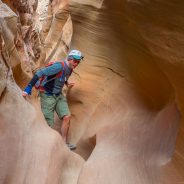
The desert of Southern Utah offers some of America’s most iconic scenery for adventurers in the west. The five national parks provide many choices and locations for people to enjoy this fascinating landscape.
Over the years their popularity has skyrocketed, and that has made it tough to find the peace and solitude many of us seek while enjoying nature. Fortunately for us the desert is vast and mostly undeveloped, giving us far more opportunities to recreate outside of the parks than in them.
Many of these trails are on BLM land, which means you can bring your dogs, avoid the crowds and often not have to pay to enjoy it. Sure you might have trouble finding a bathroom facility or sometimes even paved roads, but these are the things that make it so much more interesting.
Keep in mind when traveling to remote desert areas that you need to do a little more planning, bring a little more gear, and have a backup plan. Let people know where you are going and when you should be back. Many of these places have no cell phone reception and are very far from medical facilities. Bring your first aid kits and extra provisions.
All slot canyons have serious flash flood risks, and you need to know what’s going on with the weather in the vicinity and in the surrounding area as well. Make sure the car you drive is capable of driving on the roads you want to go on.
Here are 15 favorite adventures in southern Utah that are not in national or state parks.
Officials with the U.S. Forest Service remind the public that a dog leash law is in effect in North Carolina’s Pisgah National Forest, including roads and trails. Forest Service personnel have stepped up enforcement recently. Due to the area’s high popularity and intensive recreational use, unleashed dogs have become a safety issue, officials said in a news release.
“Unleashed dogs greatly increase the potential for accidents, whether in confrontations with other aggressive dogs, jumping on hikers or chasing runners and bicycles,” said Pisgah District Ranger Dave Casey. Dogs also may be tempted to chase wild animals causing them stress or harm. “A leash is the best way to ensure the safety of all visitors, dogs and wildlife,” he added.
The national forest is governed by federal, state and county regulations which require dogs to be kept on a leash not longer than 6 feet. If a county’s ordinance says dogs cannot be off-leash off of private property, that ordinance includes the national forest property within the county’s boundaries. Henderson, Transylvania and Buncombe counties have such ordinances. Polk County does not have an ordinance.
Forest Service personnel and county animal control officers have increased patrols, actively engaging dog owners to talk about the rule.
“Education is our preferred tool, and while most dog owners readily complied with the rule when they understood it, about a third of the dog owners have persistently continued to ignore it,” said Casey. “We are asking for your cooperation for the safety and enjoyment of all forest visitors.”
Public Affairs Officer Cathy Dowd advised visitors to use common sense and common courtesy when interacting with others in the forest. Some forest users may be uncomfortable with dogs or have had traumatic experiences with them in the past.
Individuals wanting further information may contact the Pisgah Ranger District at 828-877-3265.
The wind is up and the white horses stampede along the surface of Coniston Water, making this Lakeland icon resemble the high seas rather than the sultry bucolic setting for idyllic childhood holidays. The Old Man of Coniston is wrapped, scarf-like, in wisps of icy mist, offering only fleeting glimpses of its scarred and pitted slopes.
The setting feels rather eerie – a sense compounded by dense Grizedale forest, where closely planted conifers close out the light and separate you from the lake on the other side of the hill, Windermere.
Catch winter on a good day – clear skies, frost underfoot – and it’s a superb time of year to visit the Lake District: there’s a rawness to the landscape at this time of year that’s lacking during the busy summer months. What’s more many trees are bare, now, opening up views obscured during summer. You can see Coniston Water as you clamber uphill towards Windermere; normally the two lakes are separated from one another by Grizedale Forest.
Rather unfairly, Grizedale is like the person at a party standing in the corner with no one to talk to: neither mountain, nor picturesque woodland in the sylvan sense that got Wordsworth in a lyrical frame of mind, it abuts water rather than encircles it. Most visitors come to the Lakes for the mountain views and the shorelines. Here, though, you’re in a dense woodland of conifers and broadleaf trees.
Thanksgiving is a time to reflect on the things we have to be grateful for during the previous year: friends and family who help keep us strong during times of stress; food on the table to nourish and sustain us as we go about our daily lives; good health that enables us to reach for our goals and strive for happiness.
So I thought I would take a few moments to consider the things I am thankful for in my hiking world. Enjoying one’s passions is a path to well being… physically, mentally, emotionally, and spiritually. Think for a moment about the simple things that hiking enables for you:
What about you? What has happened in your world of hiking this past year? Add to the hiking gratitude list in the comments section below.
 I am Jeff Clark, founder of Internet Brothers, producer of this blog, and passionate about hiking. I live in Western NC near the Blue Ridge and Great Smoky Mountains. Pisgah and Nantahala National Forests are just out my door, so the content will focus on these areas, but let me know what you would like to see on the site.


Copyright © 2011-2023 Internet Brothers. All Rights Reserved. ISSN 2324-6057
Designed by Elegant Themes | Powered by Wordpress | Logo by Design Aspirations