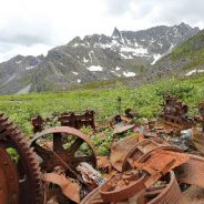
Heading up the trail, relics from the mine began to appear. Rusted-out pipes and cast-off chunks of steel, their purpose left to the imagination, lined the stream bed like a trail of bread crumbs to the mine proper.
The rusted hulks of engines, crushers, corrugated metal and sluice boxes stood like ancient sentries to the entrance of a tunnel into the side of the mountain.
The entrance was bridged by snow and partially caved in. A narrow set of iron tracks, used to ferry material from the depths of the mountain in ore carts, emerged from the tunnel. They lay on the ground, twisted and upheaved, perhaps from the constant weather changes in the high country, or maybe earthquakes.
To the north, on a steep slope of granite, there was weathered chunks of lumber scattered about and a faint trail that zig-zagged to the top of the ridgeline — as good a way as any to climb higher and deeper into the mountains.
There were signs of ptarmigan throughout the area. The hatch wouldn’t have been more than a week old, and the hens stay tucked in in those early days. But the area did show promise.
The first steps toward making a more than 300-mile walking and cycling trail from the San Francisco Bay to Humboldt Bay, crossing some of the North Coast’s most scenic, least-traveled landscapes are set to begin later this year.
Details such as when the Great Redwood Trail could be completed, how the most challenging stretches might be constructed and how much it all will cost remain big unknowns. But advocates of the ambitious plan to convert a decaying railway into a world-class pathway, potentially drawing tens of thousands of visitors to the region each year, say they’re confident it’s not a question of if it’ll happen, but when.
“Oh absolutely, absolutely. No question,” said Caryl Hart, the former head of Sonoma County Regional Parks. “Portions are already built in Willits and Ukiah, and quite a large portion in Humboldt Bay and Arcata is in the beginnings of development. It’s not like we have to find or buy the right of way — it already is there, and that is just such an advantage.”
The concept involves connecting blacktop in populated areas and segments of dirt trails in rural sections adjacent to deteriorating train tracks throughout five counties to offer a hiking, biking and horseback riding experience unlike any other. The meandering trek from Larkspur to beyond Eureka, which includes the remote, 50-mile Eel River Canyon north of Willits, would provide unencumbered, picturesque views few have laid eyes on before.
If you are looking for a solid prep hike for the Appalachian Trail or just want to hike one of National Geographic Adventure’s top North American hikes, look no further than the Art Loeb Trail near Brevard, NC.
Rather than a loop trail, the Art Loeb Trail runs northbound for 30 miles from the Davidson River Campground to the Daniel Boone Boy Scout Camp. The hike ranges from climbing up incredibly hilly terrain in the green tunnel to walking along ridgelines. The trail is no walk in the park, with trail section ratings ranging from difficult to most difficult. While the Art Loeb Trail is challenging, it is doable to complete in a weekend, if so desired.
No surprise; you can hike the Art Loeb Trail northbound or southbound. Some people believe the northbound direction is much hillier, and thus choose to hike southbound. Either way, you are going to encounter some climbing. Northbound is a bit more challenging.
Because the trail is not a loop, you will either need to take two cars and park at both trailheads, which are an hour drive apart, or use a shuttle service or guide service, which ranges from $75 to $125, depending on the company. Keep in mind that depending on which option you choose, it will either add time or cost to your trip.
One of the big decisions PCT thru-hikers have to make before choosing a start date is which direction they want to travel along the trail in. PCT thru-hikers are known as either a NoBo or SoBo hiker.
“NoBo” is short for northbound. A northbound PCT thru-hiker will start from the southern terminus at Campo, California along the US/Mexico border and hike north towards Canada. On the AT, NoBo hikers travel from Georgia to Maine.
“SoBo” is short for southbound. A southbound PCT thru-hiker will start from the northern terminus at the US/Canadian border in Washington and hike south towards Mexico. On the AT, SoBo hikers travel from Maine to Georgia.
The direction in which a thru-hiker travels along the PCT all depends on the type of hike they want to have. If a hiker is looking for a more traditional and social hike, they’ll want to travel as a NoBo hiker. If the hiker wants to escape the crowds and have a more solitary experience, they’ll often choose to travel SoBo.
There are many factors to take into consideration when a hiker is choosing the direction of their travel along the PCT. Hikers have to consider things like their desired start and finish date, weather, their hiking skill level, water availability along the trail, resupply stops and access to the Canadian border.
Lucy Barnard is on a mission to walk the entire length of the world from Argentina to Alaska with her cattle dog Wombat in tow. Lucy is an Australian adventurer on a mission to walk the entire length of the world.
“There is a moment between having an idea and acting on it, where you choose to do something. or you won’t…I decided to become the first woman to walk the length of the earth.
“It’s a 30,000 km trek from the southernmost point of South America to the highest point of Alaska. When I finish I will be the first woman, and one of only a handful to have ever completed it.
“I travel only by foot, or where the terrain is impassable, I swim or kayak.”
What makes Lucy’s story all that more remarkable is her recovery from an accident in which she had to learn to talk and walk again.
“…a ute pulled up to an intersection I was approaching. They saw me and stopped… waited for me to pass… waited… waited… and then made an error.”
Every step (and there will be 4 million of them, is documented in her blog Tangles and Tail.
2019 marks the fifth year of coordinated efforts to manage invasive feral hogs in the Highlands of Roan. These hogs damage the fragile, globally important ecosystems of Roan as they “root,” eating rare species and tearing up the terrain. They also spread multiple diseases and pose a safety threat to outdoor recreation enthusiasts.
“Since feral hogs can have devastating impacts on plants and wildlife, as well as human and livestock health, the situation requires coordinating a broad group of partners,” explains Marquette Crockett, Southern Appalachian Highlands Conservancy’s Roan Stewardship Director. “This includes federal and state agencies in both NC and TN.”
Feral Hog Working Group partners represented at a recent meeting included: U.S. Dept. of Agriculture Animal & Plant Health Inspection Services NC (USDA APHIS TN), U.S. Dept. of Agriculture Animal & Plant Health Inspection Services TN (USDA APHIS TN), NC Wildlife Resources Commission, NC state parks, TN Wildlife Resources Agency (TWRA), TN Dept. of Energy and Conservation, The Nature Conservancy, Cherokee National Forest, Pisgah National Forest, Appalachian Trail Conservancy, and private landowners in the Highlands.
Although trapping efforts have removed 40-50 feral hogs from Roan each year, it’s still not enough to effectively control the population — which would require more time and resources than currently allocated.
You’ve seen the big piles of horse poop on your favorite trails, often right in the middle of the path. They’re big and ugly and no one wants to step or ride through them — yuck.
Meanwhile, you’re packing poop-scoop bags and hauling your dog’s waste along to the nearest trash can. It can get you to wonder, if horses can poop on the trail, I can leave my dog’s there too, right? Well, wrong, and for good reason.
Since horses don’t eat meat, or anything derived from meat, horse poop is relatively “clean,” with so few bacteria, parasites or viruses that the Centers for Disease Control says that instances of humans getting sick from contact with horse manure is rare.
On the other hand, your dog poop is very toxic, with all manner of bacteria.
While horse manure breaks down rather quickly, dog poop sticks around a lot longer. It gets into ground water and spreading fecal coliform bacteria, which can make life miserable.
Bacteria can also get into reservoirs and contaminate water supplies, which then has to be treated prior to being delivered to our homes.
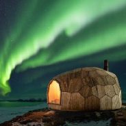
Thanks to a true community effort, weary hikers trekking along the arctic terrain of northern Norway will have a new place to rest their feet. A small cabin in Hammerfest—commissioned by the town’s local chapter of the Norwegian Trekking Association (DNT)—rises like a tortoise shell along the rough terrain. The quaint space has a wood burning stove, seating, and incredible views across the landscape that will surely recharge any hikers’ batteries.
The cabin was designed to blend with the landscape. This effect was achieved through an incredible amount of research, including the use of a drone and photogrammetry software to create a 3D map of the site. The cabin’s outer shell is made of 77 wood timber shapes that fit together snuggly like a puzzle. This is the first of two cabins commissioned, with the second to be constructed on the other side of town.
The firm faced several challenges, including designing a structure that would hold up against severe arctic temperatures and winds. The final design was tested against simulated storms to ensure that the cabin was up to the task. A second obstacle was the budget. Coming in much higher than originally thought, the increased budget meant that everyone involved had to get creative.
The great success of the first cabin means that there’s no hesitation in getting the second cabin up and running shortly.
The Hutchison Memorial Hut, colloquially called the Hutchie Hut, is one of more than 100 rustic shelters scattered throughout England, Wales and Scotland that are frequented by a motley assortment of outdoor adventurers. Left unlocked, free to use and with most offering little more than a roof, four walls and perhaps a small wood-burning stove, the buildings, called bothies (rhymes with “frothy”), are an indispensable — if for many years underground — element of British hill culture.
A vast majority of bothies are repurposed structures — crofters’ homes, shepherds’ huts, mining outbuildings — that have been salvaged from various states of disrepair by the Mountain Bothies Association, a charitable organization founded in 1965 whose aim is “to maintain simple shelters in remote country for the use and benefit of all who love wild and lonely places.”
Some, like Warnscale Head in England’s Lake District, date to the 1700s. Collectively, since they came into recreational use in the 1930s as weekend getaways (sometimes used clandestinely) for working-class laborers, bothies have given rise to a unique culture that values communal respect for fellow visitors, for the bothies themselves and for the land on which they’re situated.
But bothy culture, some longtime proponents fear, is imperiled by a generation unaccustomed to shrewdly guarded secrets. Map coordinates for the often hard-to-find dwellings, once dispersed only among hiking insiders, are now available openly on the internet. Popular hashtags have helped create something of a buzz on Instagram, where bothies are sometimes presented, misguidedly, as an alternative to Airbnb rentals.
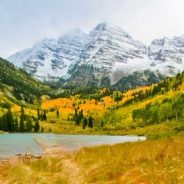
In a state known for mountains, the Maroon Bells-Snowmass Wilderness stands out among Colorado’s mountainous locales. The stunning Elk Range towers with dramatic peaks. Located just outside of Aspen, Colorado’s fourth-largest wilderness stretches over 181,000 acres and provides numerous life-list backpacking opportunities on its 100 miles of trails.
Six summits rise over 14,000 feet, including the Maroon Bells, perhaps the most photographed peaks in Colorado. Nine alpine passes surpass 12,000 feet in elevation. Numerous alpine lakes lie within the wilderness. A-list wildlife including bear, deer, elk, moose, bighorn sheep, and mountain goats all reside in the region, among many other smaller animals.
While opportunities exist to escape busier trails on some of these trips, expect to encounter other trail users. The vicinity of the Maroon Lake trailhead sees particularly heavy traffic, while outlying trails offer a little more seclusion. Most trailheads see a fair amount of peakbaggers seeking 14,000-foot summits in addition to backpackers. Due to the frequent climbing at high elevation over rough terrain, backpacking trips in the wilderness should be considered strenuous.
The Maroon Bells-Snowmass Wilderness draws hikers from throughout the country. While the creative backpacker can come up with nearly endless backpacking routes within the wilderness, here are a few of the more popular and convenient loops that can be hiked within a few days to a week. Many of these routes share some of the same trails. Each route traverses several high passes, lakes, views of 14,000-foot peaks, and some of Colorado’s best scenery.
A perfect collision of forces — an anonymous donor looking for a tax write-off, a failed subdivision that turned out to be a $40 million mortgage-fraud scheme, and strategic purchases by conservationists to protect area caves — paved the way for one of the biggest nonprofit conservation projects in the region.
Nearly 2,400 acres on Lookout Mountain and into Johnson’s Crook in Dade County, Georgia, have been preserved and will be managed by the Southeastern Cave Conservancy Inc. as the new Charles B. Henson Preserve at Johnson’s Crook.
The conservancy is now seeking help from other groups in the area to turn the preserve into a major recreation and conservation area. They plan to add more than five miles of hiking with longer connecting trails going to other preserves in the area. They envision mountain biking trails, picnicking, camping, and most of all, caving.
The property has more than 30 known caves, and the conservancy believes there are closer to 40. It contains one of the highest concentrations of caves in the Southeast, according to SCCi.
The property immediately becomes one of the biggest private conservation projects in the region. If it were a state park, it would be one of the 10 biggest in Georgia.
When it comes to planning a trip, it might seem like one has to pick between the freedom of the great outdoors and the hustle and bustle of a city. But, that’s not always true — you don’t have to pick.
There are cities around the world that are unexpectedly good for hiking, which means you can have your city adventure and your country escape at the same time. There are so many incredible cities, both domestic and international, that are backed up against a mountain, or beside a river, or next to a preserve.
Having the ability to stay in a city, while having access to miles of trails is a pretty epic double-whammy, and gives you way more bang for your buck than you thought possible.
Here is a list of cities that have truly natural hiking trails in walking distance or a very short ride from their urban center. Get the most out of your trip by choosing a dynamic location where your adventures are aplenty.
Even if you’re not into hiking, you can use the trails for other activities like birdwatching, biking, and in some cases, horseback riding. Not to mention, spending time in a new city can be exhilarating, but it will be nice to know that if you need a literal breath of fresh air, you can get it.
Here are some of the best international cities to hike in…
Occupying a few dusty acres between nowhere and Roosevelt Lake, the blink-and-you’ll-miss-it community of Jake’s Corner is a popular way station for outdoor enthusiasts.
Its ramshackle appearance and come-as-you-are ambiance are big draws for anglers, hunters, boaters, bikers and ATV riders. Sometimes, hikers find the place, too.
Located 22 miles north of the lake along State Route 188 in Gila County, the watering hole is the northern outpost of a string of RV parks, creaky-floor honky-tonks, bait shops and general stores.
The scenic stretch of SR 188 runs through the Tonto Basin, a drainage gorge that separates the wilds of the Mazatzal Wilderness and the Sierra Ancha Mountains. Dozens of creeks and streams flow off the foothills into the major course of Tonto Creek, which feeds Theodore Roosevelt Reservoir.
Other than the state-traversing Arizona Trail, which makes a grueling climb through the mountainous terrain to the west, there aren’t many non-motorized routes nearby unless you go 20 miles north to Payson. But, hiking on shared trails can be just as enjoyable when common courtesy is applied.
Directly across from Jake’s Corner Bar, a maze of forest roads offer miles of boots-on-the-ground exploratory options. Like the adjacent community, the walkabouts here harbor no pretense. They are signed simply and retain a raw, no-nonsense air.
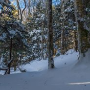
Clear cold days, rime ice, outstanding views, ice crystals hanging from spruce bows, solitude on a snow-covered trail and no bugs — these are some of the many reasons many take to the mountains during the winter season. A winter tramp in the woods and mountains can be an experience that some would say is addicting. Others cannot fathom the idea of trekking up a mountainside in three feet of snow, with the wind howling and temperatures hovering around zero. But with careful planning, appropriate skills, and knowledge, it can be a wonderful, exhilarating experience with incredible intrinsic and physical rewards.
However, a winter hike can also end in misery or even disaster if you are not properly prepared.
If you are contemplating a winter hike, there are several things you need to consider. First and foremost is planning. Research the route or trail you plan to hike. Write down the trip itinerary (route, day/time start and end the hike) and leave this with a friend or spouse. Check the most recent weather report. As most of us know, weather can change quickly in the mountains, so you need to be prepared for any and all conditions. In addition, the conditions at the base of the mountain or the trailhead are usually much different than at higher elevations, particularly on the summits.
Dress like an onion, in layers. Proper clothing and layering are the most important part of any winter journey. Layering enables you to easily adjust your clothing to regulate body moisture and temperature. After you begin hiking, your body will start to warm. You do not want to get overheated and sweat. Adjust your layers of clothing to prevent heat buildup and sweating.
People enjoy hiking for a variety of reasons, but many of those who hit their local trails do so for the exercise the activity provides.
However, there’s a big difference between breaking a sweat and working out your muscles during a hike and biting off more than you can chew. You don’t want to wear yourself out and require assistance getting back to the trailhead. Conversely, you don’t want to head out for an afternoon in hopes of working out your calves and burning a bunch of calories only to find that the trail you chose is no more challenging than a sidewalk.
To avoid either eventuality, you’ll need to pick a trail that suits your skill and fitness level. This will help you have a great time and achieve the goals you’ve established.
There is no widely recognized, universal trail-rating system. Different parks, trail guides, hike leaders, websites and books subscribe to different rating systems, making apples-to-apples comparisons hard. Some rating systems use numbers to rate trails, while others employ the easy-moderate-strenuous convention. Still others use variations of these approaches.
The Sierra Club rating system is primarily based on the length of the trail and the elevation change hikers will encounter while completing it. This system breaks trails down into one of three categories: Easy, Moderate or Strenuous.
Locating an open public restroom in Great Smoky Mountains National Park should be easier starting this week but finding someone to suggest a good spot for a family hike or to replace a washed out trail bridge won’t be.
Workers are reopening limited facilities and in a few locations around the park that had been closed during the partial federal government shutdown, park officials announced Sunday, January 13, 2019.
They include restrooms at Smokemont Campground, located just off U.S. 441 about 5 miles north of the park entrance at Cherokee, and those at Deep Creek Picnic Area near Bryson City.
The changes that began Sunday are part of a National Park Service initiative to reopen some areas or facilities using revenue from user fees. That money ordinarily goes to enhance park facilities, additional visitor services or major maintenance projects.
Damage to parks, overflowing trash cans, litter and human waste have been reported in national parks around the country during the shutdown. People with two nonprofit groups that support the park say those problems appear to be less in the Smokies but there have still been issues.
Nineteen years ago, the British government passed one of its periodic laws to manage how people move through the countryside. The Countryside and Rights of Way Act created a new “right to roam” on common land, opening up three million acres of mountains and moor, heath and down, to cyclists, climbers, and dog walkers.
It also set an ambitious goal: to record every public path crisscrossing England and Wales by January 1, 2026. The British Isles have been walked for a long time. They have been mapped, and mapped again, for centuries. But that does not mean that everything adds up, or makes sense.
Between them, England and Wales have around a hundred and forty thousand miles of footpaths, of which around ten per cent are impassable at any time, with another ten thousand miles that are thought to have dropped off maps or otherwise misplaced. Finding them all again is like reconstructing the roots of a tree.
In 2004, a government project, named Discovering Lost Ways, was given a fifteen-million-pound budget to solve the problem. It ended four years later, overwhelmed. “Lost Footpaths to Stay Lost,” the Daily Telegraph reported. Since then, despite the apparent impossibility of the task, the 2026 cutoff has remained on the statute books, leaving the job of finding and logging the nation’s forgotten paths to walkers, horse people, and other obsessives who can’t abide the muddled situation.
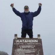
The saying, “Age is just a number,” is more of a motto for one 75-year-old Canton, GA resident, who proved that adage, completing the 14-state, 2,200-mile Appalachian Trail last month.
Richard Smith, known to those on the trail and many in Canton as “Old Scout,” completed the momentous hike in what is known as the “AT Flip-Flop.” Instead of hiking from Georgia’s Springer Mountain through to Maine’s Mount Katahdin, he hiked from Harpers Ferry in West Virginia to Maine, took a combination of trains and buses back to Harpers Ferry and completed the hike back to Springer Mountain in December.
“Most people start their through-hike at Springer Mountain in Georgia and hike north to Mt. Katahdin. I didn’t want to do it that way, because the trail (has) too many people hiking north at the same time. By doing a flip-flop, I avoided the crowds and had much more private time. There were days when I didn’t see another person on the trail,” he said.
Smith said recently that he has always hiked and had hiked portions of the Appalachian Trail for the past 50 years. He said last spring it “felt like it was time to put it all together.”
“I wanted to challenge myself, both physically and mentally. A through-hike is more of a mental challenge than it is a physical challenge. I wanted to show my grandchildren that no matter your age, with proper planning and commitment to a goal, you can accomplish anything you want,” he said. “I hope at some point in their lives, when they are faced with a challenge that seems impossible, they will look back on my hike and think, ‘If Pop could hike 2,190 miles at age 75, surely I can overcome this challenge.’”
 I am Jeff Clark, founder of Internet Brothers, producer of this blog, and passionate about hiking. I live in Western NC near the Blue Ridge and Great Smoky Mountains. Pisgah and Nantahala National Forests are just out my door, so the content will focus on these areas, but let me know what you would like to see on the site.


Copyright © 2011-2023 Internet Brothers. All Rights Reserved. ISSN 2324-6057
Designed by Elegant Themes | Powered by Wordpress | Logo by Design Aspirations