
The Mountains to Sea Trail spans the width of North Carolina, running from the Great Smoky Mountains in the west, to the Outer Banks of Coastal Carolina. Much of the trail in the mountainous part of the state is near or parallels the Blue Ridge Parkway. This section of the MST along the parkway has been designated a National Recreation Trail. With elevations well above...
Learn More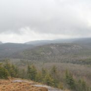
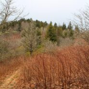
Situated in the far northern reaches of the Panthertown Trail System in Nantahala National Forest, Turkey Knob and Blackrock Mountain offer long distance views of the more well known features of Panthertown Valley. From more than 4000 feet elevation, there are splendid views of Little and Big Green Mountains and The Great Wall. The full expanse of Mac’s Gap lays on...
Learn More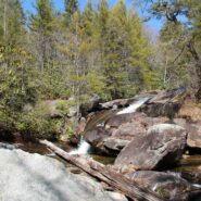
Tucked away in the northeastern corner of DuPont State Forest in Western North Carolina, Stone Mountain is the highest point in the state forest at 3620 feet. Appropriately named for the exposed granite slab that traverses its summit, Stone Mountain offers a near 360° view of the surrounding terrain to winter hikers. Wintergreen Falls, though not as spectacular as...
Learn More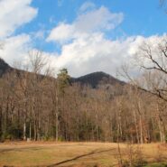
Falls Creek Falls is a double cascade in the northeast corner of the Mountain Bridge Wilderness in upstate South Carolina that free falls more than a hundred feet. In winter there is a distant view of the top of the falls from 800 feet below at the trailhead on Falls Creek Rd. From the falls, Hospital Rock Trail climbs Standingstone Mountain along Falls Creek for ridge...
Learn More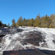
Transylvania County, NC is known as the “Land of Waterfalls,” and for good reason. There are more than 250 waterfalls in the county, with many of the most spectacular falls in the heart of DuPont State Forest. Included among those are Bridal Veil and Grassy Creek Falls, both classic slide waterfalls that carve their way over large granite slabs. DuPont also...
Learn More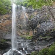
Jones Gap State Park sits on the Blue Ridge Escarpment in northwestern South Carolina very near the state line with its neighbor to the north. Along with Caesars Head State Park, these two share an area known as Mountain Bridge Wilderness. The Jones Gap Trail follows the Saluda River along an old interstate road built by Solomon Jones in the 1850s. In this backcountry...
Learn More
Thompson Creek Trail climbs Thompson Ridge from Forest Road 1206 to a point just below the Pisgah Inn on the Blue Ridge Parkway. To the southwest it overlooks the Cradle of Forestry National Historic Site and the Pink Beds. To the east it crosses from Transylvania County into Henderson County and joins the Pilot Rock Trail along the Slate Rock Ridge for the descent...
Learn More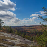
DuPont State Forest, in western North Carolina between Hendersonville and Brevard, was sold to the state by DuPont Corporation under favorable donation and conservation terms in 1996. Within its boundary are more than 10,000 forested acres and 80 miles of hiking and biking trails. Elevation ranges from 2300′ at Hooker Falls on the Little River to 3600′ on...
Learn More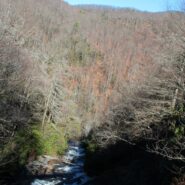
Matthews Creek plunges more than 1,000 feet over Raven Cliff Falls into the gorge it has carved below Raven Cliff Mountain. One of a myriad of landmarks along the Blue Ridge Escarpment in Caesars Head State Park, this gorge offers a very challenging yet rewarding hike. Part of the Mountain Bridge Wilderness Area that also includes Jones Gap State Park, this is the most...
Learn More
Donated to the Carolina Mountain Land Conservancy by Dr. and Mrs. Thomas Florence in 1996, the Florence Nature Preserve is 600 acres on the slopes of Little Pisgah Mountain. With more than five miles of public hiking trails, much of them along a beautiful mountain stream, the preserve contains old growth forest, views of Hickory Nut Gorge, remnants of old cabins, and...
Learn More
Looking for a hike that includes streams and rivers, hardwood and conifer forests, plentiful rhododendron, and some climbing for good measure? Then the trails along South Mills River that embark from the Turkeypen Trailhead may be just the ticket. Situated in the southeastern corner of Pisgah National Forest, the Mills River Area is the largest in the Pisgah Ranger...
Learn More
Chimney Rock State Park is one of the newest in North Carolina. The state acquired the land from private ownership in 2007, and the Carolina Mountain Land Conservancy continues to obtain additional parcels in the Hickory Nut Gorge to eventually expand the state park. The Rumbling Bald section of the park is separate from the more famous namesake, Chimney Rock. Because...
Learn More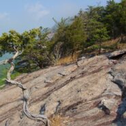
Perhaps the most popular hike in the Pisgah Ranger District of Pisgah National Forest, the Looking Glass Rock Trail is a good 3-mile leg stretcher to the top of the famous pluton. Probably not the most scenic hike is the area, but definitely popular because of ease of access, and a little less difficulty than some of the steeper monoliths. Looking Glass Rock is home to...
Learn More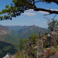
Most of the attention in Linville Gorge is focused on the northern features. There are more trails, higher peaks, and family recreation areas. But the south gorge is every bit as compelling and beautiful, with spectacular panoramic views up the gorge and westward to Pisgah National Forest and the Blue Ridge Mountains. Shortoff Mountain is a thousand feet lower than its...
Learn More
Montreat is a small community just north of Black Mountain, NC with a world renowned conference center, a college, and best for us, 20 miles of hiking trails that rival those in nearby Pisgah National Forest for quality and scenery. In particular, the Greybeard Trail is an exceptional workout that climbs more than 2300 feet to the summit of Greybeard Mountain on the Blue...
Learn More
You don’t have to climb to 6000 feet to get spectacular views of the Smoky Mountains. In fact, Mt. Cammerer has some of the best views in the national park, yet doesn’t even reach 5000 feet. You can see Snowbird Mountain and the Pigeon River Gorge to the east, and Mt. Sterling south, and the full expanse of the national park to the west. Mt. Cammerer was...
Learn More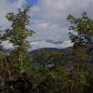
Kind of an unusual name for the mountain this trail is named after, but it is at 5,200 feet, so the snow comes earlier in the season, and more frequently than in the valleys below. North of Asheville, NC on the Blue Ridge Parkway, this hike is in the Craggy Gardens area. There are splendid views of the Great Craggy Mountains and the Black Mountains from the three summits...
Learn More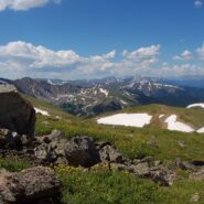
Perhaps one of the reasons you head for the Colorado Rockies is the wealth of national parks and monuments. Maybe you enjoy the amazing increase in distance from high altitude golf. If you are a hiker, perhaps you welcome the opportunity to climb one of Colorado’s famous fourteeners. If that’s the case then this hike up Clear Creek County’s 13,234 foot...
Learn More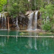
I first visited Hanging Lake in 1982. I heard this summer that the federal government had designated the site a National Natural Landmark, so it piqued my curiosity to take a look again. Glenwood Canyon is a rugged and remarkably scenic place with tall red sandstone cliffs rising 1300 feet on both sides of the Colorado River. The trail up the canyon to the lake follows...
Learn More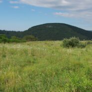
Flat Laurel Creek is in the area just north of the Pisgah Ridge and in between the Shining Rock and Middle Prong Wildernesses. It drains from Sam Knob and Little Sam Knob and runs to the West Fork of the Pigeon River. The trail that bears its name starts at the headwater and travels 3.7 miles around the west side of Little Sam until it meets Hwy. 215 and joins the...
Learn More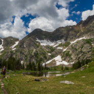
Missouri Lakes Basin in the Holy Cross Wilderness is one of the most beautiful areas in Colorado for hiking and camping that I have experienced. It is an area of lakes and streams filled with trout and large glacial boulders, surrounded by lush forest and tundra, and the gnarly cliffs of the Sawatch Range in the Holy Cross Wilderness. There is some of just about every...
Learn More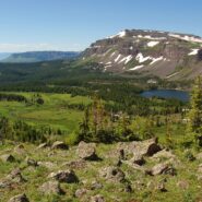
Flat Tops Wilderness is the second largest U.S. Wilderness Area in Colorado. Located near the towns of Yampa and Steamboat Springs, it is 235,214 acres, with 38,870 acres in Routt National Forest and 196,344 acres in White River National Forest. The area is named for a series of flat top mountains that dominate the landscape. This is sub-alpine and alpine terrain with...
Learn More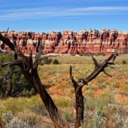
Canyonlands National Park is in the southeastern corner of Utah, near Arches and Dead Horse Point. It is divided into four distinct districts: Island in the Sky, Needles, Maze, and Horseshoe Canyon. The Needles District forms the southeast corner of Canyonlands and was named for the colorful spires of Cedar Mesa Sandstone that dominate the area. The district’s extensive...
Learn More
Perhaps it seems I’ve been spending quite a bit of time hiking in the eastern section of Shining Rock Wilderness in recent months. I can’t help myself. The terrain is wild, the forests ever-changing, the views exhilarating, and the exercise invigorating. The elevation changes dramatically — more than two thousand feet. The air is cool and refreshing...
Learn More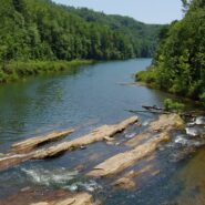
Gorges State Park was developed as a unique partnership of industry, the environmental community and the state of North Carolina. In 1999 more than 10,000 acres of the Jocassee Gorges in Transylvania County were purchased by the state from Duke Energy Corporation. The transaction created a 2,900-acre Gameland managed by the N.C. Wildlife Resources Commission, as well as...
Learn More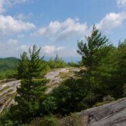
This is an extension of the trail report about the Panthertown Trail System in Nantahala National Forest from a previous post. When we explored Panthertown last November, we knew very little about it and kind of fumbled our way along the myriad of trails. Since, we have studied the trail system map and had a plan that included going to the top of Big Green Mountain, a...
Learn More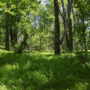
Looking at a trail map or topographic map, the area of this hike within Shining Rock Wilderness can be somewhat confusing. There is the Greasy Cove Prong, a creek that runs off of the Grassy Cove Ridge. The trail is called Greasy Cove, but it starts/ends at Grassy Cove Top. I think the guys who named the area may have had a touch too much huckleberry wine. Regardless of...
Learn More
This a continuation beyond the hike described in the Black Balsam Knob and Tennent Mountain trail report. The Art Loeb Trail continues down the north side of Tennent Mountain to Grassy Cove. There it meets the Ivestor Gap Trail for a lengthy hike into Shining Rock Wilderness. The area was named by the Cherokee for the large deposits of quartz found along what has become...
Learn More I am Jeff Clark, founder of Internet Brothers, producer of this blog, and passionate about hiking. I live in Western NC near the Blue Ridge and Great Smoky Mountains. Pisgah and Nantahala National Forests are just out my door, so the content will focus on these areas, but let me know what you would like to see on the site.


Copyright © 2011-2023 Internet Brothers. All Rights Reserved. ISSN 2324-6057
Designed by Elegant Themes | Powered by Wordpress | Logo by Design Aspirations