
Tucked away in the northeastern corner of DuPont State Forest in Western North Carolina, Stone Mountain is the highest point in the state forest at 3620 feet. Appropriately named for the exposed granite slab that traverses its summit, Stone Mountain offers a near 360° view of the surrounding terrain to winter hikers. Wintergreen Falls, though not as spectacular as other waterfalls in DuPont, is nonetheless charming as Grassy Creek tumbles through a deep mixed forest. The name was chosen for the evergreen ground cover known as teaberry that is prevalent along Grassy Creek. The two trailheads are separated by less than a mile on Sky Valley Road. This hike occurred on Thursday, March 1, 2012 from 10:20am to 2:10pm. The plan was to take the Rocky Ridge Trail to the Stone Mountain Trail, then on to the summit. Return would be by the Switchback Trail. Then, after a short stretch on Sky Valley Road I would take the Tarklin Branch Trail to Wintergreen Falls Trail, returning on the Sandy Trail to Tarklin Branch.
Hike Length: 7.9 miles Hike Duration: 3.75 hours
Hike Rating: Stone Mountain, moderate | Wintergreen Falls, easy
Blaze: No blaze, trails are easily navigable
Elevation Gain: 660 feet Hike Configuration: Two separate lasso hikes
Trail Condition: Excellent, except Stone Mountain Trail which is rocky and rutted.
Starting Point: Both trailheads are on Sky Valley Road.
Trail Traffic: I encountered two other hikers on the summit of Stone Mountain, and nine hikers in three groups going to Wintergreen Falls.
How to Get There: DuPont State Forest can be accessed from Hendersonville, NC via Kanuga/Crab Creek Rd., from Asheville/Brevard via US64 and Little River Rd., or from Greenville, SC via Cedar Mountain and Cascade Lake Rd. Sky Valley Road is in the northeast corner of the forest. Look for printed trail maps at public parking areas.
Both of my regular hiking partners were unavailable, so I purposely chose a hike that would be relatively safe and not technically difficult since I would be hiking alone. DuPont State Forest is usually my go-to destination for beautifully scenic, yet not physically demanding adventures.
There are two ends to the Rocky Ridge Trail that meet up with the Stone Mountain Trail. The southern end is on Sky Valley Road, is a 2.4 mile round trip, and rises 660 feet to the summit. The northern end starts on the Old CCC Road very near the junction with Sky Valley Road, adds a mile to the total distance and 500 feet more elevation gain. Since I planned two hikes on this day, I chose the simpler, shorter route.
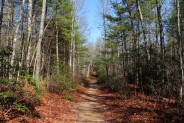
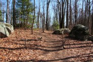
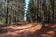
The southern Rocky Ridge trailhead has a parking area large enough for a half dozen cars on the left side of Sky Valley Road less than two miles up from Old CCC Rd. The trail is wide and pleasant, and sandy with an indistinguishable uphill grade. This northeastern section of the state forest is dense woodland with a delightful mix of deciduous and evergreen trees.
You will discover the DuPont State Forest trail system to be quite robust. I reached two trail junctions on the short 1.2-mile hike up Stone Mountain. The first is .4 mile in. The Rocky Ridge Trail bears left and eventually down to the Old CCC Rd. and the Stone Mountain Trail turns right. Then just another tenth mile later, the Switchback Trail bears right and Stone Mountain takes off uphill to the left. I saved the Switchback Trail for the return, and headed onward up Stone Mountain.
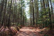
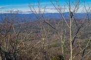
The Stone Mountain Trail begins moderately steep climbing right away and continues uphill until the summit. Unlike the near perfect conditions on the Rocky Ridge Trail, this trail is rocky and rutted from drainage. Still, a good trail considering the terrain conditions. Just a touch less than a mile in, the trail turns a decidedly northeasterly direction and climbs to a large grassy clearing perhaps two acres in size. Passing through the meadow, I climbed another tenth mile past several large boulders alongside the trail, then began the final climb to the summit.
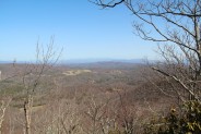
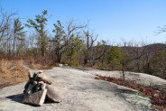
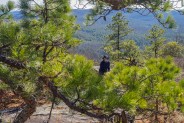
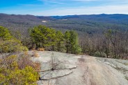
The last tenth mile is the steepest. The good news is that the trail isn’t far as it climbs through laurel and rhododendron. Before I knew it I popped out on top of a very large exposed granite summit topped with an annoying cairn and gnarly wind-swept pines. The summit surface is quite large and flat and affords long-distance views in nearly every direction. Be sure to spend some time exploring the summit. You can walk several hundred feet left or right.
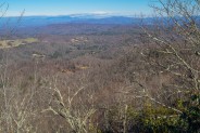
 To the left is a northerly view toward Asheville with the Great Craggy and Black Mountains behind. Looking west is the high country of Pisgah National Forest. Straight ahead is the radio tower topped Pinnacle Mountain, one we crossed by car the day we hiked to Cedar Rock in DuPont. You can also see the clearings in the forest that are the horse farms along Pinnacle Road.
To the right is the most expansive view, stretching far and wide toward South Carolina. There is another communications tower barely visible many miles away that sits atop Rich Mountain in Transylvania County. Below is the southwestern area of DuPont State Forest. When you go, see if you can pick out some of the more notable landmarks.
If you packed a picnic lunch, there are numerous great spots on the granite to sit for awhile and enjoy the picturesque surroundings. Speaking of lunch, while on top, I enjoyed following the circuitous path of a lone buzzard hovering on the wind a hundred feet above me. I felt strong on this day, so no worries that he was circling for me.
On the way back down I thought I’d mix it up a little and take the Switchback Trail instead of Rocky Ridge. It carves a ‘V’ through the forest on its way to the Frank Street Trail. Both are flat and serene as they amble through the forest. I heard the first sounds of songbirds, a sure sign spring isn’t far away. Even the laurel was just a little greener than the week before. The Frank Street Trail comes out on Sky Valley Road just a couple hundred yards east of the parking area for Rocky Ridge.
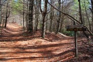
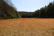
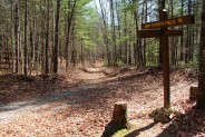
To begin the 2nd part of my hike I hopped in the car to drive about ¾ mile down Sky Valley Rd. to the Guion Farm parking area. There are several trails that begin here including Flatwoods, Buck Forest, and the one I was after, Tarklin Branch. At the south end of the parking is a trail kiosk with a map of DuPont State Forest, surrounded by a large grassy area about the size of two football fields. Tarklin Branch Trail is at the end of the field on the right.
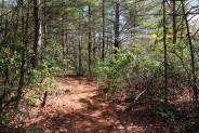
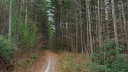
 Tarklin Branch follows its namesake creek through a very tall pine forest that dominates the trail. These pines stand nearly a hundred feet as they reach for the sky and creak musically in the breeze. Tarklin Branch Trail used to be a road, so it is quite wide and flat; very easy hiking. After about three-quarters mile I took a left on Wintergreen Falls Trail.
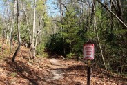
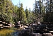
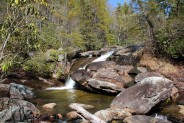
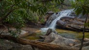
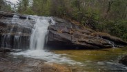
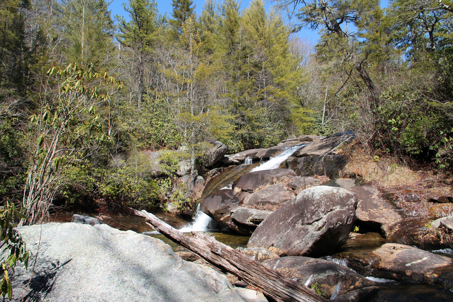
It’s 1/3 mile to another junction, this time with the Sandy Trail. I stayed on Wintergreen Falls but decided I would take Sandy Trail on the way back to see what was up. About a hundred feet before the falls is an ominous sign that reads, “Injury or Death Possible. Stay on Marked Trail.” Once I reached the falls area, I could see why. Wintergreen Falls sits in a gorge carved by Grassy Creek through the forest. It is surrounded by boulders and logs that make navigation difficult and dangerous. I took it very slow and cautious as I weaved my way over and around the wet slippery rocks that were just waiting for a misstep.
Once you get through the boulder field there is a great flat spot at the base of the falls that’s perfect for lunch and pictures. I stayed for 20 minutes munching my sandwich and snacks and getting out the mono-pod for some photo memories. The sun had warmed the day so much that I removed my pullover and was totally comfortable in a t-shirt. Could this really be March 1st? I can’t emphasize enough the beauty of this scene. See the photo at the top of this post. Wintergreen Falls isn’t tall, only 20 feet. It isn’t particularly wide either. For me it’s the combination of isolation along with the forest, sky, rock and water that make this an idyllic place.
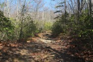
On the way back, I hugged Grassy Creek to get a feel for the extent of the gorge. It’s a typical mountain creek, filled with boulders and long ago swept away timber. When I reached the junction, I took Sandy Trail back. It continued to follow Grassy Creek to its meeting with Tarklin Branch. There are a couple places where you can cross the creeks to head into the central section of the state forest where all the spectacular waterfalls are. The final return is back the way I came, through the tall pines on Tarklin Branch.
This was a very enjoyable way to spend 3-4 hours. Neither hike is especially tough. Only that last tenth mile before the Stone Mountain summit is remotely difficult. Combining the two hikes is a nice way to savor forest, mountain, vista, and waterfall. I encourage you to make DuPont State Forest your go-to destination for accessible winter hiking.
Update 01/01/2015: Made another trip to Stone Mountain on New Years Day, 2015.


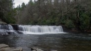
Update 11/17/2015: A cloudy day in mid-November made for a delightful visit to Wintergreen Falls. The colors along Tarklin Branch Trail were very nice. At the end of the hike, took a short trip to Hooker Falls as well.


The following are paid links. As an Amazon Associate I earn from qualifying purchases.
 I am Jeff Clark, founder of Internet Brothers, producer of this blog, and passionate about hiking. I live in Western NC near the Blue Ridge and Great Smoky Mountains. Pisgah and Nantahala National Forests are just out my door, so the content will focus on these areas, but let me know what you would like to see on the site.


Copyright © 2011-2023 Internet Brothers. All Rights Reserved. ISSN 2324-6057
Designed by Elegant Themes | Powered by Wordpress | Logo by Design Aspirations
In case any of your readers are wondering – the section of the Rocky Ridge Trail from Old CCC Road to Stone Mountain Trail is seriously rocky and eroded as well. I was a bit surprised at the condition of this section of the Rocky Ridge Trail as well as the Stone Mountain Trail given how most of the other trails in DSF are relatively well graded and maintained. I guess this area of DSF is less traveled (I didn’t see another person in this NE area yesterday whereas the area near most of the waterfalls was overrun with people) so it gets less treatment than the well used area to the West.
Also a bit curious to me is that the DSF trail map I have lists the next peak to the East as Stone Mountain. There is a narrow footpath that lead down the East side of the granite dome. I followed for about 25 yards and it appears to go to the next peak. I wonder if it just a misprint on the map or if that next peak is actually Stone Mountain proper.
Hi Ashevillain. Thanks for the tips.
I’ve noticed more than one error on the trail maps provided by DuPont State Forest. I don’t know when they were last updated, but it seems to be time.
I checked and the current revision is listed as 2012. Hopefully they’ve made some corrections.
I have the 2005 and 2008 revisions. The 2005 version is even worse – it has S T O N E M O U N T A I N stretched out over 3 different peaks in that corner. That’s pretty vague!