
There are 84 named trails in DuPont State Forest. This robust and mature trail system is a series of arteries that connect the various and disparate sections of this family friendly recreation area. In the central region of the state forest I put together a semi-loop hike that took me first to a waterfall, then to a hilltop summit, and finally to the tranquil banks of a mountain lake. Along the way I was able to enjoy the thoroughly entrancing forest and its wide variety of wildflowers and fungus. I took this hike on Friday, July 25, 2014 beginning at 8:15AM and ending about 12:30PM. My plan was to follow the roads and trails within DuPont to visit Grassy Creek Falls, Table Rock, and Lake Dense.
Hike Length: 10.2 miles Hike Duration: 4.25 hours
Hike Configuration: Out and back, semi-loop
Hike Rating: Moderate. Somewhat difficult simply for the length.
Elevation Gain: 940 feet Blaze: Not needed in DuPont
Trail Condition: Very good. DuPont trails and roads are well maintained.
Starting Point: DuPont State Forest Visitor Center on Buck Forest Road.
Trail Traffic: I had the trails to myself until reaching Lake Dense.
How to Get There: DuPont State Forest can be accessed from Hendersonville, NC via Kanuga/Crab Creek Rd., from Asheville/Brevard via US64 and Little River Rd., or from Greenville, SC via Cedar Mountain and Cascade Lake Rd. Look for printed trail maps at public parking areas.
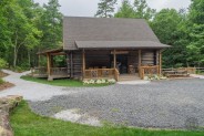
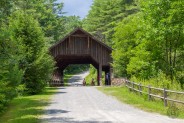
This hike begins at DuPont State Forest’s new Visitor Center on Buck Forest Road. Opened in summer 2013, the log cabin Visitor Center adds even more charm to DuPont’s superior recreation facilities. Start by heading through the gate and up Buck Forest Road, or if you like you can take a short side trip to High Falls. Cross the covered bridge over Little River, then remain on Buck Forest Road at the junction with Conservation Road.
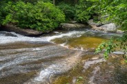
As you continue on Buck Forest you will pass Chestnut Oak Road on your right. Remember this, because you will be coming back this way after your visit to Grassy Creek Falls. About the time you pass this junction you will begin to hear the rush of the waterfall to your left. Continue downhill a little further where the road makes a sweeping left curve and meets Lake Imaging Road after crossing Grassy Creek. Turn left here, and continue uphill for less than a quarter mile. The Grassy Creek Falls Trail will be on the left.
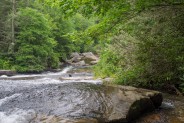
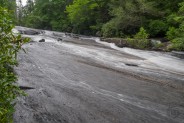
It’s a mere hundred yards to an observation point at the top of Grassy Creek Falls. Be careful near the falls, as the combination of granite, water, and algae makes for a very slick surface on this slide waterfall. I snapped a few photos, left my pack, and followed the volunteer trail down the hill to the base of the falls where I took a few more pictures. There is a small plunge pool here that would be nice for wading and splashing on a hot summer day.
Back to that Chestnut Oak Road junction I headed, and began the climb up into the central region of the state forest. As you walk these gravel roads through the beautiful forest here, think back to the people and conservancies who had the forethought to preserve this land for future generations back in the mid-1990’s. At that time, it had already been snatched up by developers, and these roads you walk now would have eventually become addresses for carpet bagger trophy homes.
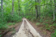
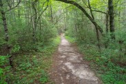
About a quarter mile up Chestnut Oak Road, look for Oak Tree Trail on your left. This very sandy half mile is a connector between Chestnut Oak and Joanna Road. It was interesting to see the hoof prints left in the heavy sand from the equestrians that had passed along this trail in recent days. When you reach Joanna Road, turn left, and the majority of the climbing is done. Joanna Road continues deeper into the forest for another mile, also on a sandy pathway, taking you into the most remote area of DuPont.
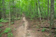
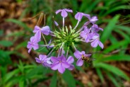
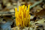
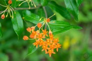
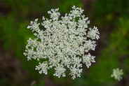
As you reach a rise on Joanna Road, the Table Rock Trail is on your right. It continues slightly uphill, then levels out for the next half mile. The total length of Table Rock Trail is 0.9 mile, with one final uphill push to the summit. Along the way, I passed a wide variety of wildflowers including geraniums, daisies, queen anne’s lace, and little micro gardens of toadstools and other fungus that are common in the damp summer forests of Western North Carolina.
When I reached the top of Table Rock Trail, I was a little disappointed because I was hoping for an overlook of Lake Julia. With a name like Table Rock I was thinking rock outcropping. Not to be though. The summit sits just above the eastern inlet of the lake. Unfortunately, the best time to get a view here would be in winter when the leaves are down. I explored a little off trail looking for a vantage point, but it was not to be, so I pulled up a piece of ground and enjoyed a snack.
Returning to Joanna Road, my next destination was to be Lake Dense. It is approximately two miles from the Table Rock Trail junction to the Pitch Pine Trail connection on Joanna Road. Most of this is flat double-track so you will make good time as you stroll through the forest. Pass by Oak Tree Trail and continue on Joanna Road.
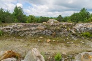
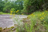
Not long afterward you will reach what appears to be an old quarry. At least there is a lot of broken rock there. This clearing is a vantage point of the mountains that overlook DuPont State Forest. You will see a number of very large granite slabs that surround this domed area, much like those found in the Cedar Rock region of the forest.
Joanna Road begins a descent beyond this point and eventually reaches the Pitch Pine Trail. I encountered my first other person of the day as a mountain biker came riding up Pitch Pine from Lake Dense. For three hours I’d had the forest all to myself, so I was a little startled when I saw the colorful biker togs. Turn left on Pitch Pine to head to the lake.
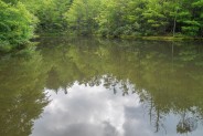
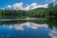
It’s just a tenth mile to the eastern end of Lake Dense. After the long stretch on Joanna Road I was getting pretty hungry so I sat in the grass beside the lake to enjoy lunch. I could hear others having a great time at the other end of the lake as their loud splashes indicated some kind of diving pier. Unfortunately, the maintenance workers were also out and their chain saws kinda harshed the mellow mood. It was odd, as chain saws aren’t something you hear in national forests. I suppose the state doesn’t mind.
Pushing myself up from the ground, I placed my hand right on a yellow jacket in the grass. Not surprisingly, she didn’t like that very well and decided to put a hole in the palm of my hand. While having a little internal scream in pain, I noticed there were several yellow jackets hovering in the grass. Lucky I didn’t sit on their nest.
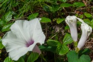
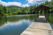
Continuing around the lake on the Pitch Pine Trail I passed several beautiful swamp hibiscus and reached the northeastern shore where all the recreation facilities are. Included are two piers and a picnic shelter. There was a nice couple setup at the shelter taking photos from the pier. They introduced themselves and we talked cameras for awhile, then their companion said they were there for an Overland Unlimited tour. Apparently they operate guided jeep tours in the Blue Ridge and Smokies. So if there are any of you landscape photographers out there who find it difficult to get around on the hiking trails, you might want to consider Overland Unlimited.
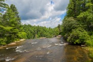
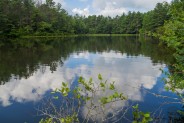
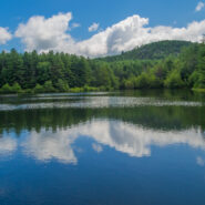
I took several pictures myself including the one at the top of this post. The weather was perfect and the puffy white clouds cast a cottony reflection on the surface of the lake. A young family was teaching their toddler how to wade in the water and for a little while I was able to simply live in the moment. It’s a very nice spot.
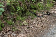
For future reference, from here you can head south on the Three Lakes Trail and also go to Lake Alford and Lake Julia. By now, though, I’d had a very complete morning and was ready to head back. So I went north where I rejoined Joanna Road a hundred yards later. Before getting back to the road I got to meet a 6′ black snake who was having a bit of trouble climbing the bank beside the pathway. Glad he wasn’t around where I sat for lunch.
Joanna Road meets Conservation Road for a final quarter mile back to the covered bridge on Buck Forest Road. After going three hours without seeing anyone, I must have encountered 20 people on this little stretch out to enjoy the afternoon. There was an interesting scene awaiting me at the bridge as I managed to capture horseback riders, a mountain biker, and several hikers all in one photo. To me, that summed up perfectly what DuPont State Forest is all about. No matter how you like to get around, there are trails that everyone can enjoy.
In summary, this 10-miler will give you a good idea what DuPont State Forest has to offer. In this case, waterfalls, forest and lakes. There’s quite a bit of walking in between, but isn’t that why you’re out there? The trail system at DuPont is so complete that you can get between features very easily. Make an entire day of it, or head there for a short hike after work. Regardless, you’re bound to have one of those special moments just like I did.

The following are paid links. As an Amazon Associate I earn from qualifying purchases.
 I am Jeff Clark, founder of Internet Brothers, producer of this blog, and passionate about hiking. I live in Western NC near the Blue Ridge and Great Smoky Mountains. Pisgah and Nantahala National Forests are just out my door, so the content will focus on these areas, but let me know what you would like to see on the site.


Copyright © 2011-2023 Internet Brothers. All Rights Reserved. ISSN 2324-6057
Designed by Elegant Themes | Powered by Wordpress | Logo by Design Aspirations


The main picture is quite stunning. I’m surprised you were able to get that type of mountain-lake reflection photo here in NC.
It requires a little help from the elements including a calm wind so the lake surface is relatively smooth. The clouds also help with the perspective. Most of the work, though, is already done by Nature.