
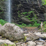
Sometimes you have to work for the reward at the end of the trail. Hiking from Craggy Gardens to Douglas Falls is a prime example. You will descend 1,350 feet from the Blue Ridge Parkway to this 70-foot waterfall through a luscious forest of birch, maple, and beech, even enjoying old growth hemlock along the way. Expect a rough hike, as the terrain is very rugged in the...
Learn More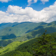
Hiking among the giants of the East. That’s what you’re doing when you take the Blue Ridge Parkway to Mt. Mitchell State Park for this trek on the Mountains to Sea Trail in the Black Mountains. With fabulous views of the Blacks and the Great Craggy Range, and closeup experiences with gnarly old growth fir and spruce krummholz, this stretch of the MtS is some...
Learn More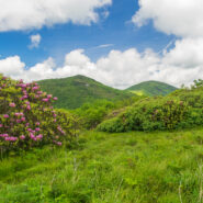
June means catawba rhododendron at Craggy Gardens. Located northeast of Asheville on the Blue Ridge Parkway, Craggy Gardens is loaded with the purple and maroon beauties. There are two short, easy trails near the Visitor Center that access mountaintops for spectacular vista views and bunches and bunches of rhodies. Craggy Pinnacle takes you above 5,800 feet for a view of...
Learn More
There’s a trail from Scenic Hwy 276 that parallels the Blue Ridge Parkway as it winds around 10 ridges and makes 13 easy stream crossings on its way to the Pisgah Inn on the Parkway. Buck Spring Trail eventually ends up at the site of the former hunting lodge of George W. Vanderbilt II, the father of Pisgah National Forest. In the spring this trail is alive with...
Learn More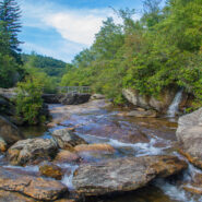
Graveyard Fields is an anomaly — a high mountain meadow and bog surrounded by 6,000 foot mountain peaks. The wide-open spaces found at Graveyard Fields are a rarity, an exception in the otherwise lush and densely forested slopes of Pisgah National Forest and Shining Rock Wilderness. Popular with locals and tourists alike, no trip to the high country of Western...
Learn More
Back to Rough Butt Bald Overlook on the Blue Ridge Parkway, and another visit to the Mountains to Sea Trail. The MST follows, or remains close to the Parkway through much of Western North Carolina, so there are a number of easily accessible jumping off points that head into the backcountry. Middle Prong Wilderness was designated in 1984 and spans rugged high-elevation...
Learn More
Quite frequently in winter, the Blue Ridge Parkway will be closed for snow and ice. Not great fun for those who wish to drive along the beautiful ridges. Ah — but it’s the perfect time for hikers to get out on the trails that parallel the Parkway — like the Mountains to Sea. Between Pigeon Gap and Bennett Gap at miles 412-414 the Mountains to Sea Trail...
Learn More
Between mileposts 423 and 424 on the Blue Ridge Parkway, Scenic Hwy 215 crosses at Beech Gap. If you head about 1/4 mile north on 215, the famous Mountains to Sea Trail crosses from the Black Balsam area into Middle Prong Wilderness. The MtS winds through an ever-changing forest that runs the gamut of evergreens found in the high country of Western North Carolina. Past...
Learn More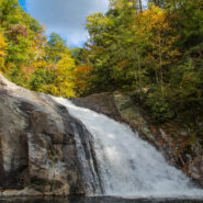
One of the highlights of the Wilson Creek Wild and Scenic River area is Harper Creek Falls. Located in the Grandfather Mountain Ranger District of Pisgah National Forest, this three-tiered falls is a fun place to swim, slide and dive — but the rugged terrain makes for a difficult and dangerous access. The Harper Creek Trail is easy enough. With the exception of a...
Learn More
Another of the myriad of ridge and gap trails from North Mills River to the Blue Ridge Parkway. Bad Fork Trail follows its namesake creek from Forest Road 5000 to Bent Creek Gap at mile 400 on the Parkway. This is a four mile round trip that can be extended by continuing on the Mountains to Sea Trail on the north side of the Parkway. Only moderately steep, this is a nice...
Learn More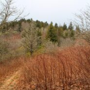
The Mountains to Sea Trail spans the width of North Carolina, running from the Great Smoky Mountains in the west, to the Outer Banks of Coastal Carolina. Much of the trail in the mountainous part of the state is near or parallels the Blue Ridge Parkway. This section of the MST along the parkway has been designated a National Recreation Trail. With elevations well above...
Learn More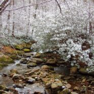
The Middle Prong Wilderness is west of North Carolina Hwy. 215 and north of the Blue Ridge Parkway. It is named after the Middle Prong of the Little Pigeon River that runs through the heart of the wilderness. This is remote territory in the high country near 6000 feet. Prepare yourself for heavy breathing — from exertion, and from natural beauty. Buckeye Gap Trail...
Learn More I am Jeff Clark, founder of Internet Brothers, producer of this blog, and passionate about hiking. I live in Western NC near the Blue Ridge and Great Smoky Mountains. Pisgah and Nantahala National Forests are just out my door, so the content will focus on these areas, but let me know what you would like to see on the site.


Copyright © 2011-2023 Internet Brothers. All Rights Reserved. ISSN 2324-6057
Designed by Elegant Themes | Powered by Wordpress | Logo by Design Aspirations