
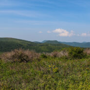
Milepost 420 on the Blue Ridge Parkway is where you will find Black Balsam Road. It’s a short drive to a spruce forest where the Art Loeb Trail crosses the road and heads up onto the balds. This is North Carolina high country. There are several mountains greater than 6000 feet with treeless summits, affording spectacular 360° views of the surrounding Blue...
Learn More
Nestled in the woods of Pisgah National Forest in Asheville, the North Carolina Arboretum is a 434 acre public garden located within the Bent Creek Experimental Forest. Set amid rolling hills just off mile 393 of the Blue Ridge Parkway, the Arboretum offers more than ten miles of groomed hiking trails that are suitable for all ages. Home to one of the finest, most unique...
Learn More
This is a two-part hike with a short drive on a forest service road in between. Both the Case Camp Ridge Trail and the North Face Trail start on Forest Road 475B in Pisgah National Forest. The first climbs 1000 feet in 1.7 miles to the Blue Ridge Parkway near Cherry Gap at mile 416. It’s a short walk from the trail to the Cherry Cove Overlook and a close-up view of...
Learn More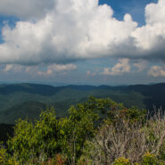
Pilot Mountain stands 5084 feet above the western edge of Pisgah National Forest, near the Blue Ridge Parkway and Looking Glass Rock. There are three ways to get to its summit, but the one I enjoy most is the section of the Art Loeb Trail from Gloucester Gap along Forest Road 475. It isn’t particularly long, but it is quite strenuous. You will get your exercise...
Learn More
Another of the myriad of hikes along Forest Road 475 in Pisgah National Forest, this two-parter is near the Fish Hatchery and Pisgah Center for Wildlife Education. First we took a short trip up Forest Road 475B to Slick Rock Falls, then hiked to the base of Looking Glass Rock. The climbers love this area and we encountered some when we reached the base. The main hike was...
Learn More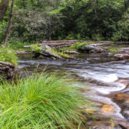
The Riverside Trail along the South Fork of Mills River in Pisgah National Forest is a great opportunity for boys to be boys, and girls to laugh at them, as the trail fords the river several times. You’ll get to wade in a crisp, cool mountain stream up to your knees as you negotiate the current and the smooth, slippery rocks on the bed. Enjoy the peaceful sounds of...
Learn More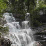
A spectacular waterfall isn’t the only highlight of the Ramsey Cascades Trail in the Greenbrier area of Great Smoky Mountains National Park. The trail to the cascade gains more than 2,000 feet as it follows rushing rivers and streams filled with moss-covered boulders for its four-mile length. The last couple miles pass through old-growth hardwood forest with giant...
Learn More
It’s all about the importance of giving back and passing forward… So says the masthead at Summit Stones & Adventure Musings, a fount of wisdom and inspiration that dares to take us to the “wild places,” the summits, canyons and waters of our imagined and realized adventures. True to his aspirations, DSD as he is known, has blessed me with an...
Learn More
Usually when you come here you will find a cheerful description of a scenic hike that was fun, and that I recommend for your enjoyment. Instead, I am going to suggest that you stay away from this hike if you value your safety and security. The Brush Creek and Burnett Gap Trails are so terribly maintained as to make them virtually impassible. I’m sure at one time...
Learn More
With so much interest in The Hunger Games movie, I thought it was time to head out to DuPont State Forest for a dawn hike to Triple Falls, one of the scenes in the film. Triple Falls is a tiered cascade on the Little River that drops 120 dramatic feet and was also featured in the Last of the Mohicans movie. A photo of Triple Falls was used by the Friends of the Falls...
Learn More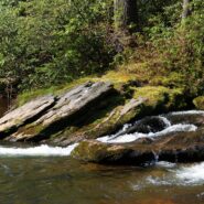
Designated a National Wild and Scenic River, the Chattooga River’s headwaters are in North Carolina, but it stretches into Georgia and South Carolina as well. In fact, at one point known as Ellicott Rock, it marks the common tri-boundary of all three states. There are more than 50 miles of trails along the Chattooga River but this four-mile stretch just south of...
Learn More
North Mills River Recreation Area in Pisgah National Forest, along with its brother at South Mills River, has a rich trail system. It covers the Pisgah Ridge at the Blue Ridge Parkway down to the North Mills River. A combination of trails leading from the Trace Ridge Trailhead at the recreation area go up, over, and around Coffee Pot Mountain on the way up to the...
Learn More
The Mountains to Sea Trail spans the width of North Carolina, running from the Great Smoky Mountains in the west, to the Outer Banks of Coastal Carolina. Much of the trail in the mountainous part of the state is near or parallels the Blue Ridge Parkway. This section of the MST along the parkway has been designated a National Recreation Trail. With elevations well above...
Learn More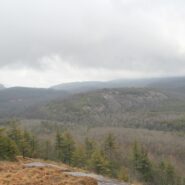
Situated in the far northern reaches of the Panthertown Trail System in Nantahala National Forest, Turkey Knob and Blackrock Mountain offer long distance views of the more well known features of Panthertown Valley. From more than 4000 feet elevation, there are splendid views of Little and Big Green Mountains and The Great Wall. The full expanse of Mac’s Gap lays on...
Learn More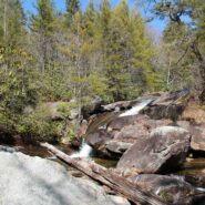
Tucked away in the northeastern corner of DuPont State Forest in Western North Carolina, Stone Mountain is the highest point in the state forest at 3620 feet. Appropriately named for the exposed granite slab that traverses its summit, Stone Mountain offers a near 360° view of the surrounding terrain to winter hikers. Wintergreen Falls, though not as spectacular as...
Learn More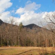
Falls Creek Falls is a double cascade in the northeast corner of the Mountain Bridge Wilderness in upstate South Carolina that free falls more than a hundred feet. In winter there is a distant view of the top of the falls from 800 feet below at the trailhead on Falls Creek Rd. From the falls, Hospital Rock Trail climbs Standingstone Mountain along Falls Creek for ridge...
Learn More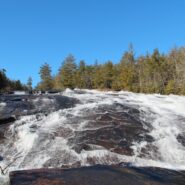
Transylvania County, NC is known as the “Land of Waterfalls,” and for good reason. There are more than 250 waterfalls in the county, with many of the most spectacular falls in the heart of DuPont State Forest. Included among those are Bridal Veil and Grassy Creek Falls, both classic slide waterfalls that carve their way over large granite slabs. DuPont also...
Learn More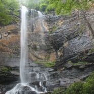
Jones Gap State Park sits on the Blue Ridge Escarpment in northwestern South Carolina very near the state line with its neighbor to the north. Along with Caesars Head State Park, these two share an area known as Mountain Bridge Wilderness. The Jones Gap Trail follows the Saluda River along an old interstate road built by Solomon Jones in the 1850s. In this backcountry...
Learn More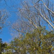
Thompson Creek Trail climbs Thompson Ridge from Forest Road 1206 to a point just below the Pisgah Inn on the Blue Ridge Parkway. To the southwest it overlooks the Cradle of Forestry National Historic Site and the Pink Beds. To the east it crosses from Transylvania County into Henderson County and joins the Pilot Rock Trail along the Slate Rock Ridge for the descent...
Learn More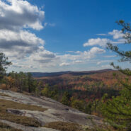
DuPont State Forest, in western North Carolina between Hendersonville and Brevard, was sold to the state by DuPont Corporation under favorable donation and conservation terms in 1996. Within its boundary are more than 10,000 forested acres and 80 miles of hiking and biking trails. Elevation ranges from 2300′ at Hooker Falls on the Little River to 3600′ on...
Learn More
Matthews Creek plunges more than 1,000 feet over Raven Cliff Falls into the gorge it has carved below Raven Cliff Mountain. One of a myriad of landmarks along the Blue Ridge Escarpment in Caesars Head State Park, this gorge offers a very challenging yet rewarding hike. Part of the Mountain Bridge Wilderness Area that also includes Jones Gap State Park, this is the most...
Learn More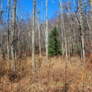
Donated to the Carolina Mountain Land Conservancy by Dr. and Mrs. Thomas Florence in 1996, the Florence Nature Preserve is 600 acres on the slopes of Little Pisgah Mountain. With more than five miles of public hiking trails, much of them along a beautiful mountain stream, the preserve contains old growth forest, views of Hickory Nut Gorge, remnants of old cabins, and...
Learn More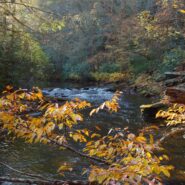
Looking for a hike that includes streams and rivers, hardwood and conifer forests, plentiful rhododendron, and some climbing for good measure? Then the trails along South Mills River that embark from the Turkeypen Trailhead may be just the ticket. Situated in the southeastern corner of Pisgah National Forest, the Mills River Area is the largest in the Pisgah Ranger...
Learn More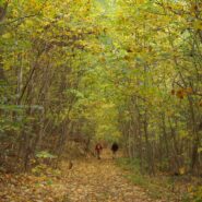
Chimney Rock State Park is one of the newest in North Carolina. The state acquired the land from private ownership in 2007, and the Carolina Mountain Land Conservancy continues to obtain additional parcels in the Hickory Nut Gorge to eventually expand the state park. The Rumbling Bald section of the park is separate from the more famous namesake, Chimney Rock. Because...
Learn More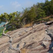
Perhaps the most popular hike in the Pisgah Ranger District of Pisgah National Forest, the Looking Glass Rock Trail is a good 3-mile leg stretcher to the top of the famous pluton. Probably not the most scenic hike is the area, but definitely popular because of ease of access, and a little less difficulty than some of the steeper monoliths. Looking Glass Rock is home to...
Learn More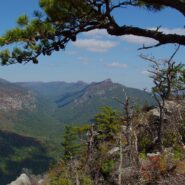
Most of the attention in Linville Gorge is focused on the northern features. There are more trails, higher peaks, and family recreation areas. But the south gorge is every bit as compelling and beautiful, with spectacular panoramic views up the gorge and westward to Pisgah National Forest and the Blue Ridge Mountains. Shortoff Mountain is a thousand feet lower than its...
Learn More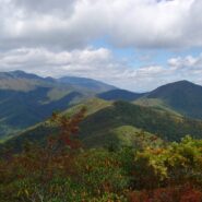
Montreat is a small community just north of Black Mountain, NC with a world renowned conference center, a college, and best for us, 20 miles of hiking trails that rival those in nearby Pisgah National Forest for quality and scenery. In particular, the Greybeard Trail is an exceptional workout that climbs more than 2300 feet to the summit of Greybeard Mountain on the Blue...
Learn More
You don’t have to climb to 6000 feet to get spectacular views of the Smoky Mountains. In fact, Mt. Cammerer has some of the best views in the national park, yet doesn’t even reach 5000 feet. You can see Snowbird Mountain and the Pigeon River Gorge to the east, and Mt. Sterling south, and the full expanse of the national park to the west. Mt. Cammerer was...
Learn More I am Jeff Clark, founder of Internet Brothers, producer of this blog, and passionate about hiking. I live in Western NC near the Blue Ridge and Great Smoky Mountains. Pisgah and Nantahala National Forests are just out my door, so the content will focus on these areas, but let me know what you would like to see on the site.


Copyright © 2011-2023 Internet Brothers. All Rights Reserved. ISSN 2324-6057
Designed by Elegant Themes | Powered by Wordpress | Logo by Design Aspirations