
Located along the North Carolina/Tennessee state line, and where Pisgah and Cherokee National Forests merge, Grassy Ridge in the Roan Highlands is the longest stretch of grassy balds in the Appalachian Mountains. The Appalachian Trail navigates this stunning ridge, hopping from Carvers Gap to Round Bald to Jane Bald, and on to the 6,169 foot Grassy Ridge Bald. The Highlands are a haven for wildlife, and mountain bushes like rhododendron, flame azalea, and green alder. Rare flowers are found here as well, including species such as spreading avens, Blue Ridge goldenrod, Gray’s lily and mountain bluet. There are clear views of Grandfather Mountain and the peaks of Linville Gorge to the east, and Mt. Mitchell and the Black Mountains to the south. In short, the Roan Highlands area is a must see. This hike occurred on Wednesday, June 19, 2013 from 8:30am to 1:15pm. My plan was to follow the Appalachian Trail from Carvers Gap across the three balds of Grassy Ridge, then explore more of Roan Mountain as time, and weather, permitted.
Hike Length: 6 miles Hike Duration: 4.75 hours Blaze: White
Hike Configuration: Out and back Elevation Gain: 1,360 feet
Hike Rating: Moderate, some strenuous climbing on rocky terrain.
Trail Condition: Mostly very good, some trenching in high-use areas.
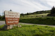
Starting Point: Trailhead at Carvers Gap on Hwy NC 261/TN 143.
Trail Traffic: High activity, although there were extenuating circumstances the day I was there.
How to Get There: From Asheville, NC take I-26 W to US-19E toward Burnsville. In Burnsville, turn left on NC 197 N for 6.7 miles, then bear right on 197 N another 4.4 miles. Turn left on NC 226 N for 3.1 miles then turn right onto Fork Mountain Road. Go 4.2 miles and turn left on NC 261 N. It is 9.2 miles to Carvers Gap. Since Roan Highlands is a very popular spot, there is plenty of parking, but get there early.
This is a hike I’ve wanted to do for quite some time, but just never seemed to get it together. It’s in a very remote area, and a long way from my home (about two hours), so I always seemed to talk myself out of it for regions with easier access. The time factor seems silly because I’ve made the effort to go to other wild places that were at least as far. Well, now that I’ve finally been, it’s not so tough to get there after all, and I’ve truly been depriving myself of one of Western North Carolina’s most remarkable gems.
When I arrived at Carvers Gap on the North Carolina/Tennessee state line just past 8:00 AM, there were already a couple dozen people milling about the parking area, and much to my surprise, the parking along the highway was already full. Well, I thought, I guess that’s what you get at peak rhododendron season. I would learn later that something else was up. Eventually I discovered there’s a whole other parking lot off the main highway, and all was good.
About that parking though, there seems to be about 60-70 spaces, but it’s a good idea to get there early in the morning, especially during busy visitor seasons like June and October. When I finished my hike just past 1:00 in the afternoon, the parking was crammed and Carvers Gap was a trafficky mess.
I couldn’t quite figure why everyone was just hanging out, but I could see if I got my pack and camera gear together quickly, that I could beat them all onto the trail. And the last thing I wanted was to get behind a mob of people starting out. The Appalachian Trail (AT) trailhead is just across the road on the east side. So off I went, somewhat confused, but tickled that I wouldn’t be behind this big crowd of folks with unknown intentions.
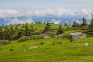
Because of the popularity, the trail track here is a light gravel with borders on each side, kinda like you might see in a city park. Fancy. The trail switches back on a grassy hillside, going in and out and around clusters of rhododendron shrubs as it leaves the cars, and people, at Carvers Gap behind. It took me less than 15 minutes, and only a couple hundred feet of climbing, to realize that Roan Highlands is a very special place.
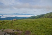
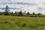
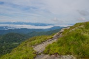
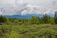
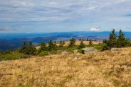
This is high country, with clear air, crystal blue sky, dazzling emerald green grasses that conjure images of Ireland, and long-distance views to the south and southwest of the blanket of valley fog. It’s why they call them the Smoky Mountains. It became apparent early on that I might as well just leave the camera on the tripod and carry it, rather than putting it away in the pack each time I moved on. This was going to be a fantastic day.
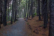
After catching my breath from the sheer stunning beauty of the southern vista, I proceeded to the next curiosity. The trail winds through a dark and mysterious spruce-fir forest tightly packed with black balsam spruce and Fraser fir. There are large igneous rocks on either side of the path, and that heavenly aroma from the evergreen needles and bark. Quite the contrast from the brightness of the meadow to the gloomy stroll through the conifers.
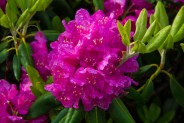
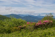
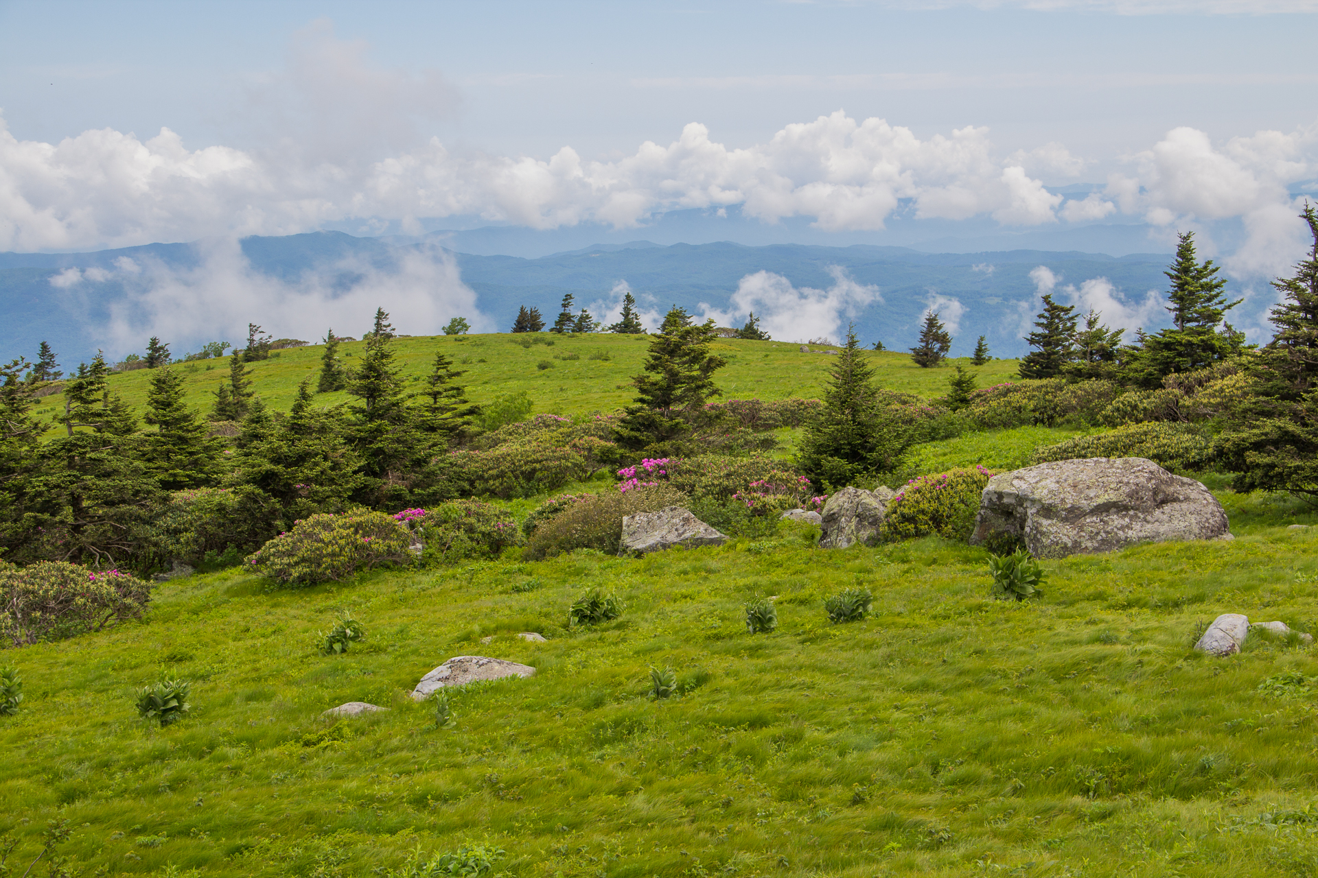
Just about the time my pupils were adjusting to the pitch of the forest, the trail was back out in the light in another series of rhododendron bushes. These are the catawba variety (rhododendron catawbiense), a dense shrub with evergreen leaves, and numerous violet-purple flower clusters bigger than your fist. The fruit is a dry capsule with numerous small seeds. They are really quite lovely, and there are more natural rhododendrons in the Roan Highlands than anywhere else in the world.
The trail continues climbing Round Bald up a series of steps about 20 feet apart. There are more terrific views of the southern mountains, and then eventually, the Tennessee side of the ridge comes into view. On this particular day, that side was even more socked in. The clouds were boiling like a witches cauldron, occasionally rolling up and over the bald.
I reached the summit of Round Bald, 5,826 feet, and was in awe of the panorama of Smoky Mountains surrounding me. The bald is aptly named. It’s like standing on a massive basketball with grass. The top is truly round. As I approached the eastern side I could see down into Engine Gap, the path of the trail a half mile away. Clouds were wafting through the gap on a race from Tennessee to North Carolina.
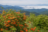
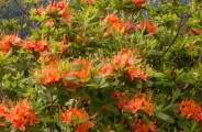
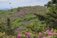
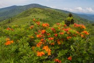
A series of switchbacks aids the descent eastward, and brings the trail closer to the edge of the forest where there is a plethora of flame azalea bushes. Much as the western slope was alive with the pink/magenta catawbas, this eastern side of Round Bald is lush with rhododendron calendulaceum. The flowers of this deciduous shrub are larger than most other native azaleas, measuring from 1.5 to 2.5 inches across, and come in a wide range of colors from ochreous yellow, through various shades of orange, almost red even. A number of the blooms on the balds are a blazing bicolored orange.
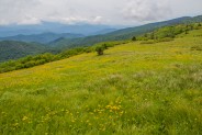
Dropping about two hundred feet from Round Bald into Engine Gap, I entered a sea of yellow hawkweed. In the late 19th century, a steam engine was setup in the gap between Round Bald and Jane Bald by logging companies (hence the name, Engine Gap) to move lumber from the Tennessee side to the mills located on the North Carolina side. Thanks to the efforts of land conservation since, I could enjoy hawkweed instead of locomotives.
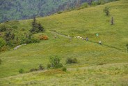
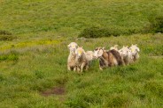
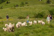
I took a glance behind me to enjoy the rhodo and azalea gardens on the eastern grade of Round Bald, and wait… What is that? Is that sheep up on the mountain? I dialed in the zoom on my camera to get a closer look. Sure looks like sheep.
Not long afterward another hiker caught up to me and I asked him if he saw the sheep behind us. He said, “Those aren’t sheep. They’re goats. We’re herding them up in the highlands for summer. When the goats approach you, you don’t want to be in front of them because it spooks them. It makes them want to scatter. So you might want to setup your camera over there on the side and catch them as they come by.”
Cool! What dumb luck! I quickly learned that I just happened to pick the day to be at Roan Highlands when they were bringing the goats up for the summer Baatany Project. Despite the somewhat cheesy name, apparently this is the sixth year of the Baatany Project, a volunteer-based effort to restore the Grassy Bald corridor on Roan Mountain using goats as an experimental management tool. Could this day get any more perfect?
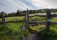
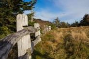
A bell dinged in my head. Now I understood why all those people were milling around at Carvers Gap. They were waiting for the goats to arrive for the drive up the balds. Unknowingly I had become a part of this year’s Baatany Project. So I spent the next half hour on the side of the trail taking pictures of the nearly two dozen goats and at least twice as many volunteers as they herded into a fenced area on Jane Bald. The babies came last.
Well, that was exciting. Now it was time to climb up Jane Bald for the next surprise. Unlike Round Bald, Jane Bald is nearly covered with granite and rhododendron. The trail is steeper, and carved through a forest of shrubs that also includes green alder, a large bush with flowers known as catkins, oblong and almost berry-like.
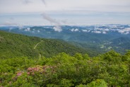
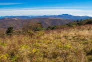
Jane Bald is smaller than the others, and six feet lower than Round Bald at 5,820 feet. The views however, are fantastic. To the west is Round Bald with Roan High Knob and Roan High Bluff beyond. To the east is the continuation of Grassy Ridge onward to Grassy Ridge Bald. To the south are the Black Mountains, including Mt. Mitchell, and to the north are the Smokies of Tennessee and Roan Mountain State Park.
The summit of Jane Bald is where the goats were penned for now. They are herded by a gorgeous Great Pyrenees. I happened to catch one of the principals of the Baatany Project and asked how often they come up to relocate the portable fences from bald to bald. About every 10 days he said. This particular breed of goat loves the Canadian blackberry, an invasive species to the Roan Highlands. Clearing that, and keeping the natural grasses “mown” are the primary jobs of the goats.
The southeastern slope of Jane Bald has a large rocky outcropping that is ideal for camera work, and nearly the entire eastern side is literally covered with blooming rhododendron and azalea. Later, from almost a mile away, this eastern face of Jane Bald appeared lit up with pink and orange. Stunning.
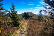
The gap between Jane and Grassy Ridge Balds dips a couple hundred feet, much like Engine Gap did. At the base of the gap is a trail junction. The Appalachian Trail continues around the next bald to the left, and a spur trail heads southeasterly up the side of Grassy Ridge Bald. I wanted to check out both, so I chose the AT first. I went about a half mile through thick rhodo thickets, passing the northern flank of Grassy Ridge, with views deep into the Smokies of Tennessee.
I passed a spring on the right, learning later that this is where the goat keepers collect water for the dog, and also hopped over a small queen snake sunning on the trail. When the AT began heading steeply down, I decided it was time to turn around and do my additional climbing on Grassy Ridge.
The spur trail up Grassy Ridge Bald is the most difficult section of this hike. It is a very narrow, rocky trenched channel that climbs 500 feet through thick rhododendron and alder scrub. The end result is definitely worth the effort, however, as Grassy Ridge Bald is unbelievably even more beautiful that Round and Jane Balds were. This trip just kept getting better and better.
Cronk. Cronk. Cronk. The tell-tale sound of ravens hovering above me was a warm welcome to the next bald on the menu. I paused to watch them floating on the breeze, swooping below the horizon then drifting back up to silhouette the clouds.
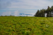
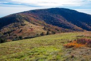
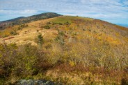
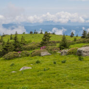
Grassy Ridge Bald is several hundred acres of green, green grassland, surrounded by spruce and rhododendron, simply stunning. Far to the east is the Grandfather Mountain massif, and the peaks of Linville Gorge, Hawksbill and Tablerock. There is a large rock outcropping near the 6,189′ summit with an imbedded plaque honoring Cornelius Rex Peake, operater of the highest cultivated farm in the U.S. east of the Rocky Mountains, and very instrumental in bringing the conservation movement to Roan Mountain.
This looked like a perfect spot for lunch. Since I left Jane Bald, I had separated myself from most of the other folks who only came to help with the Baatany Project. It became apparent who the other day hikers were as a few stopped by to break bread with me at the outcropping. One couple was from Boone, and I also met a professional photographer from Nashville who gave me several tips about when and where for Roan Highlands pictures.
He told me about the next ridge over, what he described as a “purple mountain.” I certainly wanted to see that, so after wrapping up lunch I continued southeast across the acres of grass toward another series of outcrops on the other side. Then, peaking out through a few spruce and fir, there is was. The entire face of Bear Ridge was awash in the violet/purple of catawba rhododendron. It totally beat anything I had ever seen at Craggy Gardens or elsewhere in the Blue Ridge or Smokies.
The entire length of the Roan Mountain grassy balds covers seven miles and crosses five different summits. Perhaps some other time I will continue on the AT over Yellow Mountain and Hump Mountain. But on this day, I was totally content to conclude my exploration at the end of Grassy Ridge. What a treat I’d had, and I still would get to see it all over again on the way back.
By now, the morning valley fog had lifted on both sides of the ridge, presenting higher clouds and a horizon level haze. Even more of the bicolored azalea had popped out from the afternoon sunshine, and I could see lines of hikers marching like ants two miles away on Round Bald. Yes, Grassy Ridge is a popular and special place, but it is roomy enough to not seem crowded. There is plenty of space for everyone to enjoy their own little mellow haven.
By the time I got back to my car, I had traveled six miles and taken nearly five hours to do it. That should be an indicator of just how much there is to enjoy on Grassy Ridge. You could certainly do this round trip hike in less than three hours, but why would you. There is so much to see, so much to ponder, so much to breathe, so much essence.
While there, I figured I might as well visit the Rhododendron Gardens located in the gap between Roan High Knob and Roan High Bluff. This is a $3.00 fee area that includes the Cloudland Trailhead, which crosses the Gardens and ascends the western slope of Roan High Bluff to an observation platform just below the summit. This is also the former site of the Cloudland Hotel (c. 1885-1910) at Tollhouse Gap, billed as a very ritzy health resort, especially for those suffering from hay fever. There are numerous camping sites if you want to make a mini-vacation of your visit to Roan Mountain.
Best Hike When I was standing on Grassy Ridge Bald surveying the flowers in full bloom, the large expanse of verdant grassland, 6,000 foot mountains in all directions … I came to the conclusion this is the most beautiful place I have been in all of Southern Appalachia. I’ve seen stunning scenes in West Virginia and Shenandoah, in Eastern Tennessee and the Great Smoky Mountains, in Western North Carolina and along the Blue Ridge, but they all stand a step behind the Roan Highlands. I simply can’t wait to go back — I’m already researching when the peak autumn leaf season is. Label this one the best hike I have done so far in WNC, and definitely the most beautiful among many delightful sections along the Appalachian Trail. So treat yourself, and make an entire day of it. You will be amazed, and thrilled.
I’ve posted more pictures than usual below. It was such a perfect day that I had a lot to choose from. They are sorted sequentially from the start of the day, to the end. Just click on any of the thumbnails for a slideshow that is scroll-able forward or back. I hope the photos leave you with a sense of what a remarkable place the Roan Highlands truly is.


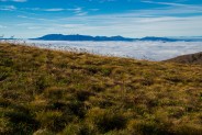
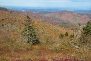
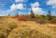
Updated October 15, 2013 — I mentioned above that I planned on returning to Grassy Ridge and the Roan Highlands in October to enjoy the autumnal coloring. And so I did. While I did find some color, as you will see in the pictures below, it’s hard to predict that perfect peak time when the hills are a total chromatic sensation.
It seemed the North Carolina side of the ridge was past peak with its browns and other earth tones. Conversely, the Tennessee side of the ridge was probably still 4-7 days away from the brightest colors. Go figure. I suppose the difference lies in being on the southern or northern side of Roan Mountain.
Regardless, I again had an absolutely splendid day. The weather was ideal for hiking — temps in the high 50s with a light breeze — and those of us who traversed the Appalachian Trail that day weren’t hassled by any law enforcement for being on the trail during the government shutdown.
Enjoy the photos. Compare the scenery to the ones above from mid-June. What a difference the season makes.


The following are paid links. As an Amazon Associate I earn from qualifying purchases.
 I am Jeff Clark, founder of Internet Brothers, producer of this blog, and passionate about hiking. I live in Western NC near the Blue Ridge and Great Smoky Mountains. Pisgah and Nantahala National Forests are just out my door, so the content will focus on these areas, but let me know what you would like to see on the site.


Copyright © 2011-2023 Internet Brothers. All Rights Reserved. ISSN 2324-6057
Designed by Elegant Themes | Powered by Wordpress | Logo by Design Aspirations


I have to say thank you for a fantastic trip blog. I have been eager to get to this area for some time and will be in a couple of weeks (mid june). What a great post! I can’t decide to camp up there or just make it a day hike being I want to shoot early morning or sunset. (I just answered that question depending on weather). I am a NC photog lurker of yours and always love your posts.
I’m happy you found this post helpful, and thanks for the kind words. I know you will have a great time at Roan Highlands. It is one of Western North Carolina’s true treasures.
Agree that this is fantastically beautiful. Well worth the drive. The balds are amazing viewpoints.