
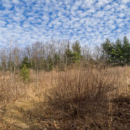
Tucked away in the northeastern corner of DuPont State Forest in Western North Carolina, Stone Mountain is the highest point in the state forest at 3,620 feet. Appropriately named for the exposed granite slab that traverses its summit, Stone Mountain offers a near 270° view of the surrounding terrain to winter hikers. Since the first time I went, nearly 12 years ago,...
Learn More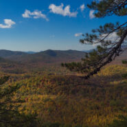
Starting at the former site of George Vanderbilt’s Buck Spring hunting lodge near Mt. Pisgah, this hike crosses the summit of Little Bald Mountain before dropping down the watershed to Pilot Rock, one of the many plutons found within the Pisgah Ranger District. The high country is home to thickets of mountain laurel and rhododendron, while various maples, oaks and...
Learn More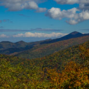
There aren’t many places in Western North Carolina better for Autumn leaf peeping than the Blue Ridge Parkway. On Monday, October 17, 2016 I set out to demonstrate that by taking a little tour between mileposts 410 and 420. But first I had to get there. I went up the Pisgah Ridge on Scenic Hwy 276, passing the Cradle of Forestry along the way. I arrived at the Cold...
Learn More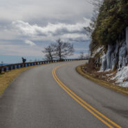
Walking the Blue Ridge Parkway in winter is a great way to get a slow-motion view of the wonderful vistas that whiz by at 45 mph in your car. The Parkway is closed so you don’t have to worry about traffic. The only concern really is perhaps slipping on snow or ice. This latest in the Photo Essay series looks at a 4-mile stretch of the BRP between mileposts 412 and...
Learn More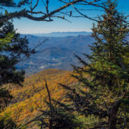
Sometimes things just don’t go exactly as planned. But making the most of what’s available is what sets hiking apart. Everything doesn’t have to go perfectly to still enjoy the day. Such was the case with this hike across the Plott Balsams mountain range from Waterrock Knob on the Blue Ridge Parkway. You’re in rarefied air here, with the entire...
Learn More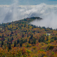
Leaf peepers head to Graveyard Fields in late September for the annual ritual of Autumn color in the high country. Located at mile 418 on the Blue Ridge Parkway, Graveyard Fields is one of the earliest locations to begin the chromatic display, as well as one of the most intense. From the bright red of the blueberry and sumac bushes, to the multi-colored hues of the maple...
Learn More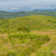
There is a notch between two wildernesses in the Pisgah National Forest high country. Shining Rock Wilderness is to the northeast, and Middle Prong Wilderness is to the west of this pie-shaped cut in the topology. In between are two bald mountaintops that exceed 6,000 feet elevation. To the locals the area is called simply… Black Balsam. The air is fresh (usually),...
Learn More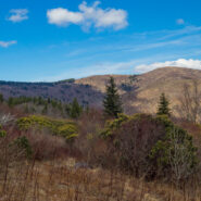
There are lots of little maintenance trails alongside the Blue Ridge Parkway that don’t show up on any trail maps or have any signs to let you know they are there. One of those is a hidden gem in the high country at milepost 420 directly across from the Black Balsam spur road. It’s great for an hour stroll to brighten you senses, or if you’re looking...
Learn More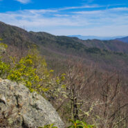
Backcountry wilderness. If you really want to get a taste, then this hike is for you. Starting at the remote Camp Daniel Boone, the northern terminus of the Art Loeb Trail enters Shining Rock Wilderness immediately. As you begin the nearly 2,000′ ascent to Deep Gap, on the southern shoulder of Cold Mountain, you will cross numerous streams as you hike through...
Learn More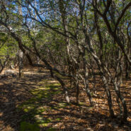
There’s a trail from Scenic Hwy 276 that parallels the Blue Ridge Parkway as it winds around 10 ridges and makes 13 easy stream crossings on its way to the Pisgah Inn on the Parkway. Buck Spring Trail eventually ends up at the site of the former hunting lodge of George W. Vanderbilt II, the father of Pisgah National Forest. In the spring this trail is alive with...
Learn More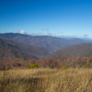
The Black Balsam area of Pisgah National Forest is surrounded by Middle Prong Wilderness on the west, and Shining Rock Wilderness on the east. Some of the best hiking found in Western North Carolina lies in this high country just north of the Blue Ridge Parkway. At the end of Black Balsam Road at milepost 420 on the Parkway, the Ivestor Gap Trail will take you deep into...
Learn More
Hickory Nut Gorge runs from Bearwallow Mountain in the northwest to Lake Lure southeast. Included in its 10-mile length are majestic cliffs of granite, inspiring waterfalls and scenic wilderness that beckons to the explorer in you. Chimney Rock State Park, Florence Nature Preserve and Rumbling Bald all offer excellent hiking within the gorge. Up in the northwest corner...
Learn More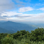
Named after the Biblical mount where Moses first saw the Promised Land, Mt. Pisgah is the landmark that gave Pisgah National Forest its name. Located on the border of Buncombe and Haywood counties in NC, close to the point where Transylvania and Henderson meet them, the mountain is easily accessible via a hiking trail from the Blue Ridge Parkway. Mt. Pisgah is topped...
Learn More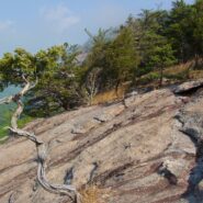
Perhaps the most popular hike in the Pisgah Ranger District of Pisgah National Forest, the Looking Glass Rock Trail is a good 3-mile leg stretcher to the top of the famous pluton. Probably not the most scenic hike is the area, but definitely popular because of ease of access, and a little less difficulty than some of the steeper monoliths. Looking Glass Rock is home to...
Learn More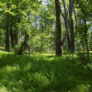
Looking at a trail map or topographic map, the area of this hike within Shining Rock Wilderness can be somewhat confusing. There is the Greasy Cove Prong, a creek that runs off of the Grassy Cove Ridge. The trail is called Greasy Cove, but it starts/ends at Grassy Cove Top. I think the guys who named the area may have had a touch too much huckleberry wine. Regardless of...
Learn More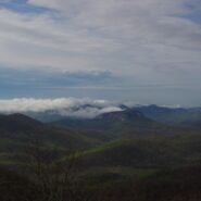
Frequently. That is how many times I have done this hike. So many, I’ve lost count. I love the western North Carolina high country, and this area along the Blue Ridge Parkway known as Black Balsam has nearly a dozen peaks over 5,800 feet elevation, with Black Balsam Knob being the highest at 6,214. This area has some of the highest hiking on the Parkway. Many of...
Learn More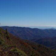
Cold Mountain gained national attention following the publishing of Charles Frazier’s Civil War era novel in 1997. Western NC hiking enthusiasts have known of its appeal for much longer. Cold Mountain is a real mountain that stretches 6030′ and is located in the Shining Rock Wilderness and Pisgah National Forest in North Carolina. You can reach the spur trail...
Learn More I am Jeff Clark, founder of Internet Brothers, producer of this blog, and passionate about hiking. I live in Western NC near the Blue Ridge and Great Smoky Mountains. Pisgah and Nantahala National Forests are just out my door, so the content will focus on these areas, but let me know what you would like to see on the site.


Copyright © 2011-2023 Internet Brothers. All Rights Reserved. ISSN 2324-6057
Designed by Elegant Themes | Powered by Wordpress | Logo by Design Aspirations