After years of work, state and federal officials finally get to cut the ribbon on the Headwaters State Forest in Transylvania County, North Carolina next week.
A ceremony will be held Sept. 6, 2018 to mark the opening of the new state forest, the Conservation Fund and the N.C. Department of Agriculture and Consumer Services announced.
Located near the border with South Carolina, the 6,730-acre forest was made possible with funding from the U.S. Forest Service’s Forest Legacy Program, through the Land and Water Conservation Fund and state and private funding.
The forest’s protection will help preserve and maintain water quality in the headwaters of the French Broad River, which flows 218 miles from Transylvania County into Tennessee. Headwaters State Forest also provides expanded opportunities for public outdoor recreation, including hiking on a section of the storied Foothills Trail.
Adjacent to more than 100,000 acres of existing conservation lands in both North Carolina and South Carolina, the area provides habitat for federally endangered plant species and other federal plant and animal species of concern. A portion of the forest will also serve as working forestland, ensuring that timber revenue and jobs stay in North Carolina.
We know plastics are as plentiful in parts of the open ocean as they are in our everyday lives. But, until recently, scientists didn’t consider that such debris could also be carrying a new wave of invasive species to the shores of the United States. Now they’re finding that not only is that happening, but they suspect that some of the species will thrive.
Not long after the 2011 earthquake and tsunami that ravaged the east coast of Japan, a surge of floating trash—shellfish cages, portions of piers, entire fishing vessels—started washing onto the West Coast of North America and Hawaii. The tsunami had dragged Japan’s plastic infrastructure out to sea, where it bobbed toward North America.
Scientists largely expected the debris to land, knowing the pace and direction of ocean currents. But they didn’t know that Japanese mussels, barnacles, and sea squirts could survive for six years on a trek across the Pacific Ocean and arrive not only alive, but ready to reproduce.
Researchers collected as much of the debris as they could over the six-year period during which it continued washing onto West Coast shores. One study documented the creatures that came with the trash and found 289 Japanese species had survived the ride.
Everything President Trump has said about President Obama’s climate plan and why he had to pull the United States out of the 2015 Paris Climate Accord turns out to be a lie.
That’s the inescapable conclusion from the EPA’s 289-page “Regulatory Impact Analysis,” (RIA) released by the administration on August 21, 2018 along with Trump’s new “Affordable Clean Energy Plan.”
This new analysis reports a very low cost of complying with Obama’s much-vilified “Clean Power Plan,” (CPP) which set the rules for cleaning up the dirty U.S. power sector and was the cornerstone of America’s climate pledge at Paris.
Trump’s EPA now calculates that achieving the emissions reductions of the CPP would cost just $700 million in 2030 dropping to $400 million in 2035. According to the new analysis, the present value of the CPP’s compliance costs would be just $3 to $5 billion — while the present value of the health, economic, and environmental benefits of the reduced pollution would be as much as $80 billion.
In short, Obama’s CPP is a no brainer — small cost, huge benefits. And remember, this is according to figures buried in calculations released alongside the announced plan to repeal the CPP.
Yet, Trump has asserted for years that the CPP was a costly mistake, and that’s why the U.S. had to become the only major country in the world to withdraw from the Paris climate accord.
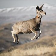
Standing in a thick patch of pine and fir, mosquitoes swarming her face, Anna Ortega lifted a radio receiver into the air, angling it back and forth as she listened for the blip, blip, blip of a mule deer collar.
A zoology graduate student at the University of Wyoming, Ortega was tracking Deer 255, a doe that had braved road crossings, fences, wolves and other hazards to get here. Somewhere in this forest near Island Park, Idaho, a dozen miles west of Yellowstone National Park, Deer 255 was laying over for the summer.
Armed with bear spray, binoculars and datasheets, Ortega and two field assistants followed the blips among trees dappled with early July sun. They picked their way through knee-high grass and shrubs, the occasional snap of a twig underfoot as startling as a slamming door. The blips were strong and clear: Deer 255 was close.
While not all mule deer migrate, some travel a hundred miles or more between their summer and winter ranges. With a one-way migration of 242 miles, Deer 255 holds the record for the longest-documented land migration in the Lower 48, traveling even farther than her herd-mates, all of which winter in the Red Desert of southwest Wyoming.
Her trek to Idaho from the Red Desert exemplifies the surprises scientists are still encountering with this well-studied ungulate. And as mule deer populations throughout the West remain below target levels, it underscores the need to protect the wide tracts of landscape that sustain migrating wildlife.
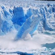
The oldest and thickest sea ice in the Arctic has started to break up, opening waters north of Greenland that are normally frozen, even in summer.
This phenomenon – which has never been recorded before – has occurred twice this year due to warm winds and a climate-change driven heatwave in the northern hemisphere.
One meteorologist described the loss of ice as “scary”. Others said it could force scientists to revise their theories about which part of the Arctic will withstand warming the longest.
The sea off the north coast of Greenland is normally so frozen that it was referred to, until recently, as “the last ice area” because it was assumed that this would be the final northern holdout against the melting effects of a hotter planet.
But abnormal temperature spikes in February and earlier this month have left it vulnerable to winds, which have pushed the ice further away from the coast than at any time since satellite records began in the 1970s.
As well as reducing ice cover, the ocean intrusion raises concerns of feedbacks, which could tip the Earth towards a hothouse state. Freakish Arctic temperatures have alarmed climate scientists since the beginning of the year. During the sunless winter, a heatwave raised concerns that the polar vortex may be eroding.
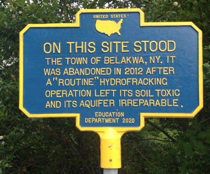
An alarming new study reveals fracking is quite simply destroying America’s water supply.
That means we are losing potable water forever in many semi-arid regions of the country, while simultaneously producing more carbon pollution that in turn is driving ever-worsening droughts in those same regions.
The game-changing study from Duke University found that “from 2011 to 2016, the water use per well increased up to 770 percent.” In addition, the toxic wastewater produced in the first year of production jumped up to 1440 percent.
The federal government “forecasts a million more wells in the next 20 years.” That would mean trillions of gallons of water used.
The Duke study warns that the water footprint of fracking could jump as much as 50-fold in some areas by 2030, “raising concerns about its sustainability, particularly in arid or semi-arid regions in western states, or other areas where groundwater supplies are stressed.”
One key point the study makes is that, unlike other energy sources, much of the water fracking uses is essentially lost to humanity. Either the water doesn’t escape the shale formation or, when it does come back to the surface, it “is highly saline, is difficult to treat, and is often disposed through deep injection wells.”
US officials have announced plans to allow increased mining on land that once belonged to two national monuments Donald Trump shrank, and to sell off some of the land despite pledges not to do so.
The two monuments, now significantly smaller in size, are both in Utah. The draft management plan for Grand Staircase-Escalante national monument includes a 98-page minerals report that outlines deposits of coal, oil and gas, tar sands and other minerals under the whole of the monument’s original 1.9m acres.
It also targets 1,600 acres for selling to neighboring property owners, although the interior secretary, Ryan Zinke, said on his second day on the job: “You can hear it from my lips: we will not sell off public lands.”
The Bears Ears national monument plan allows for mineral development in lands removed from monument status.
It is a goal of the administration to open public lands to increased industrial development. The plans follow Trump’s December 2017 executive order shrinking both monuments by a combined 2m acres, a move that prompted tribal and environmental groups and major outdoor brands to file lawsuits against the administration questioning the legality of the reduction.
Across the United States, tick- and mosquito-borne diseases, some potentially lethal, are emerging in places and volumes not previously seen. Climate change almost certainly is to blame, according to a 2016 report by 13 federal agencies that warned of intensifying heat, storms, air pollution and infectious diseases.
Last year, a coalition of 24 academic and government groups tracked climate-related health hazards worldwide. It found them “far worse than previously understood,” jeopardizing half a century of public-health gains.
Climate’s role in intensifying diseases carried by “vectors” — organisms transmitting pathogens and parasites — isn’t as obvious as in heat-related conditions or pollen allergies. But it poses a grave threat. Of all infectious diseases, those caused by bites from ticks, mosquitoes and other cold-blooded insects are most climate-sensitive, scientists say. Even slight shifts in temperatures can alter their distribution patterns.
The U.S. Centers for Disease Control and Prevention reported a tripling of the number of disease cases resulting from mosquito, tick and flea bites nationally over 13 years — from 27,388 cases in 2004 to 96,075 in 2016. Cases of tick-related illnesses doubled in this period, accounting for 77 percent of all vector-borne diseases.
This summer has felt like a global warming turning point. Now, another milestone: Saturday, August 11, 2018 was the hottest day in the history of Glacier National Park, and its first recorded time reaching 100 degrees F. On the same day, lightning started three fires in the Montana park, which has since been partly evacuated and closed. On Sunday, hot and dry winds helped the biggest fire expand rapidly.
Right now, every state west of the Mississippi is at least partly in drought, including Montana. Missoula, the closest major city to Glacier National Park, hasn’t had any measurable rain for 40 days, and none is in the short-term forecast either — a streak that will likely wind up being the driest stretch in local recorded history, beating a mark set just last year.
It’s clear that Montana is already becoming a vastly different place. In recent decades, warmer winters have helped mountain pine beetles thrive, turning mountains red with dead pines. In 1850, there were 150 glaciers in the area now known as Glacier National Park. Today there are 26. They’ve been there for 7,000 years — but in just a few decades, the glaciers of Glacier National Park will almost surely be gone. By then the park will need a new name. Glacier Memorial Park doesn’t have the same ring to it.
As bad as climate change already is in Montana and throughout the West, the prognosis for the future is much worse. Compared to 1950, Montana has had 11 more 90 degree-plus days each summer. Without rapid emissions reductions, by 2100, there could be an additional 58 more in Northern Montana. Eastern Montana could have as many as 70 more — about the same as present-day New Orleans.
This summer Southern Appalachian Highlands Conservancy purchased 234 acres in the Highlands of Roan, securing high elevation wildlife habitat and permanently protecting a corridor linking Tompkins Preserve with Pisgah National Forest in Mitchell County. This acquisition at Yellow Spot protects rare plant and animal habitat, wildlife corridors, scenic views, and sources of clean water along an important high elevation ridgeline.
“This property contains a remarkable combination of features that have made it a conservation priority for decades,” explains Marquette Crockett, SAHC’s Roan Stewardship Director. “We conserve some properties to preserve exceptional water quality and native trout habitat and we protect others because they contain rare, high elevation open areas or exceptional forest habitat – but Yellow Spot has everything. It’s a microcosm of the Roan Highlands. SAHC’s acquisition of this tract secures a perfect puzzle piece, surrounded by National Forest and protecting the main spine of the Roan Massif.”
Located within the state-designated Roan Massif Natural Area, the property rises to 5,100 ft. elevation at the peak of Yellow Spot and will provide a buffer for sensitive habitat in Pisgah National Forest. The Audubon Society’s Roan Mountain Important Bird Area covers approximately two-thirds of the tract.
“Yellow Spot has all the interesting and rare high elevation species you would expect in a property of this caliber – Gray’s lily, Carolina Northern Flying Squirrel, Northern Saw-whet Owl, Eastern Spotted Skunk, Indiana Bat, and more,” continues Crockett. “A biological inventory of the property identified six rare animal species and 12 rare plant species, including Bog Goldenrod and Trailing Wolfsbane.”
The tract contains over 2.5 miles of stream corridor, including 10 headwater tributaries of Cook Creek and Pineroot Branch, both of which are designated as Trout Waters by the NC Division of Water Resources.
Some wetlands won’t stay wet, according to new research that blends long-term observations and climate projections.
“By end of the 21st century, all five of the wetland sites studied are predicted to become much drier,” says USDA Forest Service research hydrologist Ge Sun.
The five wetlands are long-term research sites located throughout the southeastern U.S. They include:
In some of the wetlands, the water table could retreat by more than eight inches. Water tables in other areas could experience only minor changes. But even small changes in the depth of the water table – just four inches or less – may have profound impacts on wetlands.
Drier wetlands are more likely to burn. Exotic plants may also invade. The changes can cause chain reactions affecting many of the unique functions of wetlands.
August 2, 2018 at approximately 10:45 p.m., Glacier National Park rangers apprehended Raymond Reinke, age 55, from Pendleton, Oregon. Reinke was wanted following an incident earlier this week at Yellowstone National Park when he was captured on video harassing a bison.
Yellowstone National Park Superintendent Dan Wenk said, “We appreciate the collaboration of our fellow rangers in Glacier and Grand Teton national parks on this arrest. Harassing wildlife is illegal in any national park.”
Reinke had been traveling to multiple national parks over the last week. On July 28, he was first arrested by law enforcement rangers at Grand Teton National Park for a drunk and disorderly conduct incident. He spent the night in the Teton County Jail, and was then released on bond.
Following his release, he traveled to Yellowstone National Park. Rangers at Yellowstone stopped his vehicle for a traffic violation on July 31. Reinke appeared to be intoxicated and argumentative. He was cited as a passenger for failure to wear a seat belt. It is believed that after that traffic stop, Reinke encountered the bison.
Yellowstone rangers received several wildlife harassment reports from concerned visitors and found Reinke later that evening, issuing a citation requiring a court appearance. The video of the event surfaced after that citation had been issued.
On Thursday, August 2, Yellowstone rangers connected Reinke’s extensive history, and seeing the egregious nature of the wildlife violation, the Assistant U.S. Attorney requested his bond be revoked. The request was granted and on the night of August 2, a warrant was issued for Reinke’s arrest.
Reinke had told rangers that his plans were to travel to Glacier National Park. Last night, August 2, Glacier National Park rangers began looking for his vehicle. Simultaneous with that search, rangers responded to the Many Glacier Hotel because two guests were arguing and creating a disturbance in the hotel dining room. Rangers identified one of the individuals involved as Reinke.
Glacier rangers transported Reinke to Helena late last night, where they met Yellowstone rangers. Yellowstone rangers transported Reinke to Mammoth Hot Springs and booked him into the Yellowstone Jail. He is scheduled for a court appearance today.
Numerous studies, including those by the National Park Service and the University of Wisconsin have confirmed that Hetch Hetchy Valley can be readily restored. The only questions are how much human intervention is desireable and to what degree should we let nature take its course.
Removing some dams can be difficult, because sediment can build up behind them. This will not be a problem at Hetch Hetchy – there is little sediment behind the dam due to the granite rock of the Tuolumne watershed.
The Tuolumne River would immediately return to its natural course. Grasses and sedges would return on their own within a few years, and wildlife would follow.
As the reservoir is drained and the valley floor is exposed, replanting of native plants could take place as soon as the soil dries sufficiently. Revegetation could include the planting of a mixture of native trees and shrubs: black oaks, black cottonwood, white alder, Douglas fir, dogwood, willow, azalea, manzanita, and ceanothus to name a few. These species of trees and shrubs will be planted in areas where they originally existed, along with an understory of herbaceous plants.
The “bathtub ring” from the reservoir will fade naturally and surprisingly quickly, as lichen colonies return. Prescribed burning will be used to prevent conifer encroachment in oak woodlands and meadows.
There is an opportunity to create an experience of visiting Hetch Hetchy Valley that could be, at least in many respects, superior to present-day Yosemite Valley. A management plan that protects its wilderness character while maximizing opportunities for access to visitors with any sense of adventure shoud be followed.
The National Wildlife Refuge System is the largest and most diverse network of lands and waters dedicated to ensuring the long-term future of America’s rich fish and wildlife heritage. Think abundant wildlife, clean water, clean air and world-class recreation.
Managed by the U.S. Fish and Wildlife Service, the lands and waters of the National Wildlife Refuge System fall mostly along the nation’s rivers, coasts and wetlands and across its heartland. But they also extend into deserts, forests, mountains, oceans and the Arctic. From the Caribbean to the Pacific and Maine to Alaska, there are 566 national wildlife refuges.
President Theodore Roosevelt established the Refuge System in 1903 at what is now Pelican Island National Wildlife Refuge in Florida. The refuge includes the island and more than 5,400 acres of protected waters and lands in and near Indian River Lagoon on the Atlantic coast.
The Blue Goose, originated by the late cartoonist J.N. “Ding” Darling, is the symbol of the National Wildlife Refuge System. Rachel Carson, author of “Silent Spring” and former U.S. Fish and Wildlife Service biologist, said: “Wherever you meet this sign, respect it. It means that the land behind the sign has been dedicated by the American people to preserving, for themselves and their children, as much of our native wildlife as can be retained along with our modern civilization.”
The photo is black and white. It’s 8:02 p.m., according to the timestamp at the bottom of the image. The flash of the game camera extends to a narrow strip of open dirt, worn with muddy boot prints, the deep tread of machinery—and cat tracks.
Standing in the open, left of center, is a slender, fit mountain lion. It’s dark and the image is grainy, but it’s obvious the hind legs pushing the animal forward are tense with muscle. A tail drops straight away from behind them, curling gently before touching the ground, culminating with a black tip carried delicately over the dirt. The animal’s head and front legs are obscured by the tree in the foreground. The scene, even documented as a still photograph, exudes the silence of a ghost in the night.
And until October 2015, to residents of Obion County, Tennessee, the cat was a ghost. Stories of cougars in the area were only that—prevalent enough, but never confirmed. This photo was different. Submitted by a 19-year-old student and hunter to the Tennessee Wildlife Resources Agency from a game camera in one of his favorite hunting spots, this image stood out from the slew the agency receives of purported sightings.
A date and timestamp on the image, as well as the SD card on which it was recorded, convinced the TWRA of when it was taken. Superimposing photos of deer taken with the same camera showed the feline was far larger than a housecat—nearly as long as the deer. Photo analysis proved the cat wasn’t doctored or added later. And finally, the TWRA confirmed the location by returning to the scene and matching the tree, soybeans and path the cat walked along. “The TWRA can confirm there was, on September 20, 2015, a cougar in Obion County, Tennessee,” a statement read.
The problem? With the exception of Southern Florida’s small, endangered black panther population, cougars have been extinct east of the Mississippi River since the 1930s.
Republicans in the western United States have been trying to whittle away the Endangered Species Act (ESA) since Donald Trump took office. Under new proposals, wildlife managers would limit protections for species designated as “threatened” (a level below endangered), consider the economic costs prior to defending a species, and de-emphasize long-term threats such as climate change.
The proposals follow Republican bills and budget riders that would remove protections for gray wolves in the lower 48 states, exempt the greater sage-grouse from an ESA listing for 10 years, and increase state involvement in conservation decisions.
Those who study the ESA agree that reforms are needed – but the current proposals on the table are unlikely to solve the problems experts identify.
Robin Kundis Craig of the University of Utah says: “The focus should have been on endangered habitats from the beginning. By the time a species is named endangered, it’s a harbinger that something is wrong with the whole system.”
More than 1,600 species are listed as endangered or threatened, and the sage-grouse and others are nearing that threshold.
Here’s how certain species might be affected…
Throughout the eastern U.S., the invasive hemlock woolly adelgid is decimating hemlock populations. In nursery experiments on young trees, high levels of sunlight reduced the number of adelgids.
Researchers are testing that hypothesis in the forest. If the experiment has positive effects, thinning the canopy could supplement other methods like pesticides and biocontrol.
The experiment measures how the health of a hemlock tree changes when additional sunlight is introduced. For some of the hemlocks, all of the surrounding trees that shaded it were cut down. In other cases, trees were girdled—a strip of bark was removed from around the tree. Sunlight was added gradually as the girdled trees slowly died.
Every component of an ecosystem has connections to many other components, and the function of the whole depends on almost every one of its parts.
The method could be an alternative to other methods which have different trade-offs. Forest managers could select a combination of treatments that would conserve the most hemlocks at the least possible cost.
The “Ninemile’s” historic collection of buildings is part typical Forest Service ranger district, part tourist destination, and part working ranch. A standard complement of Forest Service employees works at the station—a silviculturist, District Ranger, trail crews, and others who ensure the District resources are maintained and the public is safe. But the other cowboys seen milling about have a very different role, one that exists only in this corner of western Montana.
More than 200 government-owned mules and horses board here each winter. These mules, and the horses that help wrangle them, make up the Northern Region pack train—a collection of pack animals used to maintain the vast Wilderness areas that stretch across Montana and North Idaho. Each summer, these mules are loaded with food, lumber, water, crosscut saws, and myriad other tools and packed into the Bob Marshall, the Scapegoat, the Great Bear, the Selway Bitterroot, and the other sprawling Wilderness areas managed by Region One of the Forest Service.
In the 1910s and 1920s, the Forest Service relied on horses and mules for nearly all aspects of managing its vast territory. Roads were few and far between, and the Great Burn of 1910 was still fresh in the young agency’s mind. Rangers rode horses across their huge districts and mules packed in fire-fighting tools, supplies, and rations for the growing wildland fire-fighting efforts that had become a primary focus of the Forest Service.
In those early years, the agency relied on hiring the pack animals it needed from local farmers and ranchers, but by the late 1920s, tractors and trucks did most of the farm’s hauling, plowing, and haying, and quality animals were scarce. Recognizing a need for self-provision, the Region One office of the Forest Service leased a one-square mile, run-down ranch in the Ninemile Valley, and the Ninemile Remount Depot was born. Its primary goal: supplying the agency with a reliable supply of sturdy, mountain-ready mules and horses for fighting fires.
 I am Jeff Clark, founder of Internet Brothers, producer of this blog, and passionate about hiking. I live in Western NC near the Blue Ridge and Great Smoky Mountains. Pisgah and Nantahala National Forests are just out my door, so the content will focus on these areas, but let me know what you would like to see on the site.


Copyright © 2011-2023 Internet Brothers. All Rights Reserved. ISSN 2324-6057
Designed by Elegant Themes | Powered by Wordpress | Logo by Design Aspirations