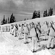
In 1942, the U.S. Army transformed a valley near Leadville, Colorado, into training grounds for its 10th Mountain Division. The high altitude, climate and steep terrain prepared World War II troops for critical battles in the Italian Alps. At Camp Hale, as the area at the headwaters of the Eagle River became known, thousands of soldiers learned to ski, mountaineer and survive in harsh winter conditions.
To build the camp, the Army Corps of Engineers brought in millions of cubic yards of fill by rail car to flatten the valley bottom. The Corps straightened the river’s natural sinuosity into a ditch system and drained the surrounding wetlands. Today, the valley bears only a few remnants of the old garrison, including the pillars of a field house that proved difficult to dismantle when the rest of the buildings were leveled.
But the river remains straitjacketed, the valley flat. “It’s a testament to the engineering that it’s still that way today,” says Eagle-Holy Cross District Ranger Aaron Mayville, “but it’s not the most healthy ecosystem.”
Now, two parallel initiatives seek to restore the ecosystem while still honoring the site’s history. One is a conservation effort that seeks to improve the valley’s ecology and to better educate visitors. The other is the Continental Divide Wilderness and Recreation Act, which, in addition to creating new wilderness and other protections in Eagle and Summit Counties, would designate Camp Hale as the nation’s first National Historic Landscape.
The current restoration plan has been successful. Spearheaded by the National Forest Foundation, the nonprofit partner of the Forest Service, the project brought together more than 40 stakeholders, including veterans, recreation groups and water rights holders.
Warming temperatures are fueling the expansion of pine and spruce beetle outbreaks across North America, Europe, and Siberia, ravaging tens of thousands of square miles of woodlands. Scientists warn that some forest ecosystems may never recover.
First, mountain pine beetles devastated lodgepole and ponderosa pine trees across western North America. Then came spruce beetles, which have targeted high-elevation Engelmann spruce, spreading from New Mexico into Colorado and beyond. Altogether, with their advance fueled by climate change, bark beetles have ravaged 85,000 square miles of forest in the western United States — an area the size of Utah — since 2000. Pine beetles also have killed trees across roughly 65,000 square miles of forest in British Columbia, and in the southeastern U.S., they have caused millions of dollars of damage to the timber industry in states such as Alabama and Mississippi.
The beetles are now advancing up the Atlantic coast, reaching New York’s Long Island in 2014 and Connecticut the following year. A new study projects they could begin moving into the twisting pitch pines of New England and the stately red pines of Canada’s Maritime provinces by decade’s end. Warming winters could push the beetles north into Canada’s boreal forest within 60 years, climate scientists say.
And from Europe to Siberia, bark beetle outbreaks are erupting with increasing frequency in woodlands weakened by rising heat and drought. Switzerland is preparing for the eventual loss of spruce, its most important tree, as warmer weather fans conditions that will make it nearly impossible for all but those high in the Alps to survive.
The Czech Republic, Poland, Germany, and Slovakia are all experiencing intense beetle attacks on their Norway spruce. In Siberia, a related spruce beetle has helped another insect pest, the Siberian silk moth, damage more than 1,100 square miles of Siberian fir, pine, and spruce since 2014.
Great Smoky Mountains National Park is hosting a volunteer trail maintenance workday on Saturday, September 30, 2017 in celebration of the 24th annual National Public Lands Day. Participants are invited to participate on a trail rehabilitation project along the Clingmans Dome Bypass Trail from 10:00 a.m. to 3:30 p.m.
Volunteers will perform trail maintenance including installation of drainage features, rehabilitation of trail surfaces, and removal of brush. While jobs may vary in complexity, volunteers must be able to hike at least 2 miles and safely perform strenuous manual labor. Volunteers should be comfortable lifting heavy objects and using hand tools such as shovels, rakes, pick-axes, and sledgehammers. Minimum age of participants is 16. Those under 18 must be accompanied by a responsible parent or guardian.
Volunteers should wear long pants, long sleeves, sturdy closed-toed shoes, and appropriate layers for cool weather. The park will provide gloves, safety gear, and tools for the day. All participants should bring lunch, water, and rain gear.
Interested participants should contact Trail and Facilities Volunteer Coordinator Adam Monroe at 828-497-1949 or [email protected] for more information and registration.
National Public Lands Day is the nation’s largest single-day volunteer effort to improve and enhance the public lands across America. This year’s celebration is expected to draw more than 200,000 volunteers at more than 2,600 sites. For more information about National Public Lands visit https://www.neefusa.org/public-lands-day.
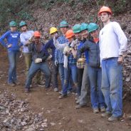
Arizona’s Natural Restorations remove trash, graffiti and anything foreign to the environment from natural areas throughout the state. They have a passion for nature and believe outdoor restoration and education ensures everyone will be able to enjoy the outdoors for generations to come. They approach every project with a commitment to long-term change and making lasting impacts in communities across the state. Natural Restorations has removed more than 116 tons of trash from Arizona national forest land so far in 2017.
Natural Restorations hosts several volunteer cleanup events each year and in February 2017, they launched a Dedicated Restoration Team working throughout the year to restore areas around the state that see continual dumping, areas too remote for volunteers, areas that are spread out over more than a few miles, and natural areas with graffiti. Through their Dedicated Restoration Team, they provide contract work opportunities, when available, to veterans.
In addition to site restorations, Natural Restorations is dedicated to educating youth and adults on the importance of caring for and restoring natural areas. They provide hands-on activities that encourage environmental stewardship, volunteerism and team building for youth, families, and communities across the state of Arizona.
A recent cleanup project along the Arizona Trail and the areas surrounding the trail on Sunday, September 10th, was a huge success. 52 volunteers, including 30 volunteers under the age of 18 years old, helped remove 5,420 pounds of trash from the area. That’s 2.71 tons of trash that is no longer littering our National Forest lands.
As of September 15, 2017, over 8,834,487 acres across the United States have been burned by wildfire, the highest number of wildfire acres burned in year-to-date records kept by the National Interagency Fire Center. The highest total acreage burned in any year on record is 9,873,745, in 2006.
Wildfire is a necessary and important part of a natural landscape, but it is undeniable that some wildfires have harsh and negative impacts on communities, water resources, outdoor recreation resources, and fish and wildlife habitat. In these cases, post-fire restoration can be crucial to prevent further damage and to spur recovery.
Loss of vegetation as a result of an intensely burning large fire can expose soil to erosion. Following such a fire, storm events or spring runoff on denuded slopes can cause ravaging floods and debris flows, which may damage structures, roads, trails, water reservoirs, put community water supplies at risk, and harm critical wildlife habitat. These adverse impacts can continue to occur for years after the fires are extinguished.
As soon as it is safe to do so, sometimes even before a fire is totally suppressed, the Forest Service begins a process called a burned area emergency response (BAER).
BAER is an assessment intended to protect life, property, water quality, important archeological resources, and impacted ecosystems from further damage. If emergency conditions exist after a fire, then, if possible, steps will be taken in attempt to alleviate emergency conditions such as helping to stabilize soil, and to control water, sediment and debris movement.
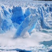
Glaciers cover one-tenth of the planet’s land surface – but not for much longer.
Glaciers worldwide are in retreat, and losing mass. They are shrinking and melting, and that will create problems almost everywhere, according to new research.
Between 2003 and 2009, glaciers melted on a gargantuan scale, with an estimated 1,350 cubic kilometres of meltwater draining from what had once been vast streams of slowly flowing ice.
Ice has been in retreat in the Gulf of Alaska, the Canadian Arctic, Greenland and Antarctica. In the European Alps summers have become measurably warmer during the last 30 years, snowfall has diminished and 54% of the ice cover in the mountains has disappeared since 1850. By 2100, Alpine summits may have lost around nine-tenths of the ice that still covered them in 2003.
In South America, the glaciers of Bolivia lost almost 50% of their mass in the last 50 years. In western Canada, somewhere between 60% and 80% of the ice measured in 2005 will have disappeared, and flowed into the sea to raise sea levels everywhere.
And, says an international team of scientists, the loss of mountain ice creates problems for the people who live downstream. Ice loss upstream means changes in the timing, magnitude and frequency of the flows downstream, and that in turn affects the levels of sediment, and the nutrients, both for the human populations who depend on the farmland in the valleys and plains below, but also for the natural ecosystems in the rivers, lakes and coastal zones.
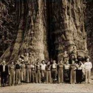
Even though the National Park Service is charged with keeping places like Sequoia “unimpaired” for future generations, it doesn’t usually step in when trees meet their end because of thirst and pestilence. Droughts and insects are supposed to be normal, natural occurrences. But it’s hard to say whether the changes witnessed here — or at neighboring Kings Canyon National Park, or at national parks across the nation — still count as normal, or even “natural,” at least as park stewardsn have long understood the term. And those changes raise a lot of prickly questions that cut to the very heart of what keepers of public lands do, and how they perceive their mission.
After all, even as tens of millions of tourists throng through their gates every year to get a glimpse of the “wild,” official policy has, for decades, directed scientists and managers to keep the parks they oversee as untainted as possible, looking as nature would if humans had never intervened. But how do you preserve the wilderness when nature itself is no longer behaving like it’s supposed to? How do you erase human influence when that influence is now everywhere, driving up temperatures, acidifying oceans, melting glaciers, and rapidly remaking the landscapes we’ve come to know as our national parks?
In Alaska, boreal forest trees are rooting into the previously treeless tundra. The javelina, a hoofed, pig-like mammal, has wandered north from part of its traditional range in southern Arizona into Grand Canyon National Park. The glaciers of Glacier National Park are withering in the heat and will probably be gone in less than 15 years.
Under the Obama administration, the park service took on climate change as a kind of combat mission. A quote from then-National Park Service director Jonathan Jarvis is still emblazoned across a number of agency websites: “I believe climate change is fundamentally the greatest threat to the integrity of our national parks that we have ever experienced.”
Those realizations were already upending the park service and its affiliated agencies when the nation elected its new president, Donald Trump, who has famously called climate change a “hoax.”
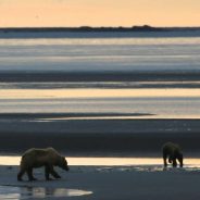
Ever wonder what the world looks like through the eyes of a brown bear? Researchers at Katmai National Park wonder, too.
To learn more, they initiated a collaborative, multi-year study examining the relationship between intertidal resources, coastal brown bear behavior, and human influences. As a part of this study, nine brown bears along the Katmai coast were outfitted with GPS location collars during the summer of 2015 to help better understand how they use intertidal resources like clams and mussels.
Two of the collars were equipped with video cameras that captured a bear’s-eye view at regular intervals. The videos reveal just what it is the bears are doing when they are out in the intertidal mudflats, wandering through meadows, or hiding in the brush. This location data, along with on-the- ground observations and the video clips will help answer questions like: How much time do bears spend in the intertidal zone? What do they do while there? What kind of intertidal resources are they feeding on?
The study has only gathered one year of data, some of which is shared through this story map, so these questions remain unanswered at the moment. But another two years of field data should start to shed more light on this important relationship between the land and the sea.
The website for this study is a remarkable production.
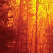
The West is burning, and there’s no relief in sight. More than 80 large wildfires are raging in an area covering more than 1.4 million acres, primarily in California, Montana, and Oregon, according to the National Interagency Fire Center. Taken together, that’s a wildfire larger than the state of Delaware.
California has declared a state of emergency as wildfires burn outside Los Angeles and threaten giant sequoias in Yosemite National Park. In Oregon, the Eagle Creek fire is tearing through the scenic Columbia River Gorge. Seattle, Boise, and Denver are socked in under a haze of smoky air and ash that experts predict could linger until the first snowfall in the mountains.
But nowhere are the fires more devastating than in Montana, where more than 1 million acres of forest burned this summer, and more than 467,000 acres are currently burning in 26 large fires that line the mountainous western side of the state.
Breathing the air in Missoula today feels like chain-smoking Chesterfields. Schools aren’t letting the kids out at recess, and public health authorities are saying active adults and children should avoid outdoor exertion. It’s easy to get the impression that this is an extraordinary and unprecedented fire season. But you study forest fires over a timespan of thousands of years. How unusual or unique is this fire season?
The largest and fastest-growing car market in the world is going to ban the sale of new gasoline and diesel cars. China has announced plans to join the rapidly expanding list of countries with plans to phase out fossil fuel-burning cars, a list that includes the UK, France, Norway, and India.
“These measures will promote profound changes in the environment and give momentum to China’s auto industry development.”said vice minister of industry and information technology, Xin Guobi, at a recent Chinese forum on cars. China has moved swiftly to be the world’s largest producer and buyer of electric cars — motivated by a desire to reduce urban air pollution, greenhouse gas emissions, and oil imports.
“Some countries have made a timeline for when to stop the production and sales of traditional fuel cars,” and his ministry will do so “in the near future,” he said.
China manufactured and sold more than 28 million vehicles last year — and still only one in five Chinese people own a car, so China’s regulations have profound implications for the global car market. Foreign manufacturers are already racing to establish partnerships with Chinese companies to manufacture electric vehicles (EVs).
Groomed, grassy fields can be good for certain uses, like sports or picnics. But for broader “ecosystem services” — things like plant pollination, disease control, soil quality and climate regulation — look to meadows.
Meadows are more than just unmowed lawns, though. They are rich, diverse ecosystems, bustling with a wide range of wildlife. And as a new study illustrates, meadows and other natural grassland habitats can be surprisingly beneficial to humans — if we let their biodiversity reach full bloom.
Published in the journal Nature, the new paper was conducted by 60 researchers from nearly three dozen universities. They studied 150 grasslands, examining how species richness and abundance relates to 14 specific ecosystem services. Biodiversity is key, but their research suggests the secret to a great grassland is a bit more complex. And given what’s at stake, we’d be wise to pay attention.
Healthy grasslands host lots of species at various levels of the food chain, also known as “trophic levels.” Humans are eroding biodiversity in many of these groups, often by developing grasslands for intensive agriculture.
“Many different groups are important for providing essential ecosystem services. In order for nature to continue ‘working’ reliably for us, we therefore need to protect biodiversity at all levels in the food chain, including in often overlooked groups such as microbes or insects.”
The Elwha River starts at Dodwell-Rixon Pass, a high crack in Washington’s Olympic Mountains. There, a hiker who crossed would find the Elwha Snowfinger, formed by heavy winter storms and the avalanches that pour off the surrounding mountainsides. Wedged into a steep-walled gully, it forms the upper reaches of the Elwha basin.
If the hiker followed this snow down, eventually she’d find a stream, and that stream would widen and become the Elwha River. As she traveled down, as more streams joined its flow, she would find one of those messy rivers that characterize the Pacific Northwest: Wide, braided channels, scattered with logs and boulders, gravel bars strewn with detritus, a sense of a landscape half-finished.
Then the river would round a corner and flow out into an area of high gravel banks stretching on for yards, dozens of feet above the water. These are what’s left of Lake Mills, one of two reservoirs that once trapped the Elwha.
Beginning in 2011, the federal government removed this dam and one lower down, blasting them away bit by bit over three years. Dozens of researchers from the U.S. Geological Survey and the Lower Elwha Klallam Tribe, University of Washington and the National Park Service, along with universities across the country, have since documented how that removal affected sediment in the water, small mammals, salmon, birds and the ocean the river flows into.
The return of this unpredictable river offers a lesson for others looking to down dams that have passed their prime. In this wildness is resilience. Slowly, with human aid, the river is carving itself a new form with a better chance of weathering disruptions, including climate change. A new Elwha, unleashed.
September 2017 is quickly becoming one of the most devastating months in history for America’s national parks and forests. From Montana to Oregon to California, national treasures in Glacier National Park, the Columbia River Gorge, and Yosemite National Park have been destroyed or threatened by wildfires.
While any single season or event cannot be attributed to climate change alone, this summer’s fires, along with the string of hurricanes that are developing one after another in the Atlantic Ocean, and record-breaking heat in the West, are all consistent with what scientists have been warning about for years: humans have changed the earth’s climate, and that change is costing both lives and billions of dollars across the country.
Considering the harsh dose of reality this summer is giving to science deniers, one might expect the National Park Service to step up its plans for addressing the impact of climate change on our parks. Sadly, the opposite is happening.
The Interior Department, led by Secretary Ryan Zinke, last month quietly issued a memo rescinding an Obama-era order that encouraged park managers to consider the effects of climate change when planning for the future.
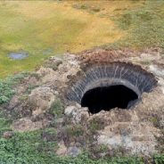
You can find evidence of a changing climate everywhere on Earth. But nowhere are the changes more dramatic than in the Arctic.
Our world’s northern polar region is warming twice as fast as the global average. And the consequences are easy to spot. On average, Arctic sea ice extent is shrinking every summer. The Greenland ice sheet is becoming unstable.
But perhaps most disturbing are the changes occurring underground in the permafrost. Permafrost is a layer of frozen soil that covers 25 percent of the Northern Hemisphere. It acts like a giant freezer, keeping microbes, carbon, and soil locked in place.
Now it’s melting. And things are getting weird and creepy: The ground warps, folds, and caves. Roadways built on top of permafrost have becoming wavy roller coasters through the tundra. And long-dormant microbes — some trapped in the ice for tens of thousands of years — are beginning to wake up, releasing equally ancient C02, and could potentially come to infect humans with deadly diseases.
A recent Arctic Council report says that 20 percent of the permafrost near the surface may melt by 2040. Already scientists have noticed permafrost temperatures slowly climbing. “In the 1980s, the temperature of permafrost in Alaska, Russia and other Arctic regions averaged to be almost 18°F,” the U.S. Geological Survey explained in 2015. “Now the average is just over 28°F.”
In 1963, Glen Canyon was pronounced dead. Glen Canyon Dam had submerged its fabled grottoes, Ancestral Puebloan cliff dwellings and slickrock chutes beneath the stagnant water of Lake Powell, and forever altered the ecology of the Grand Canyon just downstream.
For wilderness lovers, the 710-foot-tall concrete wall stuck out of the Colorado River like a middle finger — an insult that helped ignite the modern environmental movement. In 1981, the radical group Earth First! faked a “crack” on the dam by unfurling a 300-foot-long black banner down the structure’s front. The Sierra Club’s first executive director, David Brower, considered the dam’s construction a personal failure and spent the rest of his life advocating for its removal. And in his iconic novel The Monkey Wrench Gang, author Edward Abbey imagined a group of friends secretly plotting to blow up the dam and free the Colorado River.
An unprecedented interest in dam removals and the specter of climate change have created fresh hope for those who want to see the drowned canyon resurrected. From 1990 to 2010, the population of the American Southwest grew by 37 percent, even as the amount of water flowing into the Colorado River system shrank amid a historic drought. More people using fewer resources means that neither Lake Powell nor Lake Mead, the downstream reservoir created by Hoover Dam, have been full since 1999. And climate change promises to squeeze the water supply even further, with future droughts expected to bring even hotter and drier conditions.
Meanwhile, Lake Powell may be squandering the very resource it was designed to protect. Every day, water slowly seeps into the soft, porous sandstone beneath the reservoir and evaporates off its surface into the desert air.
There was a 2009 analysis in Science that found when CO2 levels were sustained in the 400 to 500 ppm range some 15 to 20 million years ago, it was 5°F to 10°F warmer globally, and seas were also 75 to 120 feet higher.
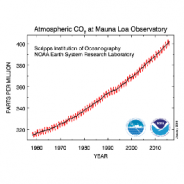
Despite the best efforts of the Trump administration to ignore or contradict scientific reality, carbon dioxide levels continue to soar far outside the bounds of what humans have ever experienced.
Monthly levels of heat-trapping CO2 peaked at nearly 410 parts per million (ppm) in May, the month that levels peak each year at NOAA’s Mauna Loa Observatory in Hawaii.
This is worrisome for several reasons. First, CO2 is the primary heat-trapping greenhouse gas humans spew into the air, mainly by burning fossil fuels. The higher CO2 levels are, the greater the warming.
Second, CO2 levels or concentrations in the atmosphere will keep rising until the world has reduced global CO2 emissions by more than 80 percent from current levels. CO2 concentrations are like the water levels in a bathtub, and annual emissions are like the flow from the faucet. The water going down the bathtub drain is like CO2 sinks such as the oceans, forests, and soils.
Third, the annual rise in CO2 levels has been speeding up, as long predicted by climate science. Indeed 2015 and 2016 were the two biggest annual jumps in CO2 levels on record.
Should you be traveling to Yosemite National Park for the Labor Day weekend, be prepared for smoky conditions and trail and road closures.
Separate fires have shut Glacier Point Road, California Highway 41 leading from Oakhurst to the southern entrance into the park, a campground and popular hiking trails.
Yosemite’s website warns visitors about smoke conditions in Yosemite Valley and beyond: “Expect poor air quality and limited visibility due to fires in Yosemite. Avoid strenuous exercise outdoors and remain indoors when possible.”
“Dense morning smoke impacts, clearing in the afternoon” was predicted for Yosemite Valley by the U.S. Forest Service’s wildfire air-quality program.
Hotels, restaurants, visitor centers and stores in Yosemite Valley are open.
As of late September 1,2017, Inciweb.gov reported these fire-related park closures…
Couple this with fires in Glacier National Park, and at least two of America’s favorite national parks are suffering.
The deadly fire fed by kindling-dry forests and whipped out of control by hurricane-force winds at Great Smoky Mountains National Park “overwhelmed” the park staff’s ability to fight it, according to an independent review of the blaze that killed 14 in neighboring communities in November, 2016.
Extreme drought conditions and heavy ground fuels – downed and dead hemlocks among them – initially fed the fire, and then hurricane-force winds on November 28 into November 29 blew the conflagration into a firestorm that swept through Gatlinburg, Tennessee, trapping many in their homes and destroying or damaging approximately 2,500 structures. Power lines downed by the winds and sparking transformers set additional fires in the town. When it was all over, 14 deaths had been reported.
The review board concluded that the “unprecedented Chimney Tops 2 Fire event exposed several wildland fire situational preparedness and planning weaknesses at the Great Smoky Mountains National Park. Despite these weaknesses, the review team found no evidence of wanton disregard or negligence by anyone at the park.”
“What was unprecedented was the combination of a severe wind event (a “mountain wave” extreme wind that usually occurs 2-4 times per year from November through March in the western foothills of the southern Appalachian Mountains), coupled with severe drought and a wildland fire on the landscape,” it added. “This scenario had never been witnessed by anyone at the park.”
Two juveniles initially had been charged with arson in connection with the blaze, but Tennessee authorities later dropped the charges, saying they couldn’t directly tie the Chimney Tops 2 fire in the national park with the subsequent fires in and around Gatlinburg.
See report recommendations here…
 I am Jeff Clark, founder of Internet Brothers, producer of this blog, and passionate about hiking. I live in Western NC near the Blue Ridge and Great Smoky Mountains. Pisgah and Nantahala National Forests are just out my door, so the content will focus on these areas, but let me know what you would like to see on the site.


Copyright © 2011-2023 Internet Brothers. All Rights Reserved. ISSN 2324-6057
Designed by Elegant Themes | Powered by Wordpress | Logo by Design Aspirations