
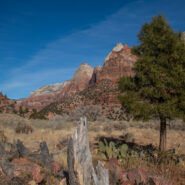
The last of our whirlwind post-Christmas Utah swing through three national parks, a state park, and BLM land, Zion is always a crowd favorite. And the crowds were out in force. Pandemic or not, holiday season or not, Zion was packed. Zion Canyon itself was closed without a reservation, so we confined our visit to the eastern side of the park. Still absolutely stunning!...
Learn More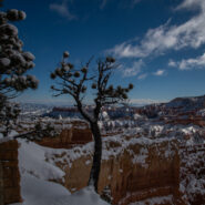
I have always dreamed of seeing the hoodoos at Bryce Canyon National Park covered in a fresh blanket of snow. Well, my dream came true, with Paula. I told you about the large snow dump that southern Utah had in the midst of our five day trip. It not only buried Escalante, but left a fresh powder at Bryce Canyon and Zion as well. My dream realized… and even better...
Learn More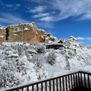
Once all was said and done, the snowfall total was 10 inches. The snow started about a half hour before we arrived at our destination, the Slot Canyons Inn of Escalante, Utah. Paula and I planned a post Christmas 2020 trip to the national parks of Utah. Our home base was to be this centrally located, cozy bed and breakfast. By the time we were settled in our room there...
Learn More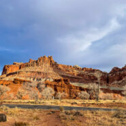
The best kept secret among the Mighty Five of Utah’s national parks, Capitol Reef is no slouch when it comes to dynamic scenery and backcountry adventure. It is remote for sure. You will likely find yourself traversing the landscape on dusty dirt roads with names like Notom Bullfrog, Grand Wash, Burr Trail Road, and Strike Valley. Following a lovely day at Goblin...
Learn More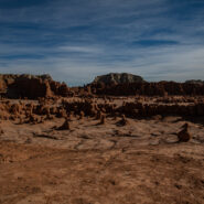
Believed to be evil, greedy, or mischievous, goblins are mythical creatures who bring trouble to humans, appearing in the folklore of multiple European cultures first attested in stories from the Middle Ages. Goblin Valley State Park, off Highway 24 at the San Rafael Swell in Utah includes an area where soft sandstone has eroded into interesting shapes, somewhat...
Learn More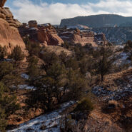
Located in the high desert canyon country of western Colorado, McInnis Canyons National Conservation Area consists of approximately 123,430 acres of BLM-administered land near Fruita, Colorado. Originally known as Colorado Canyons National Conservation Area, the NCA was established by Congress on October 24, 2000. Internationally important fossils have been uncovered...
Learn More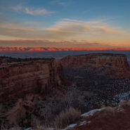
One of these days you are likely to look up and see that Colorado National Monument, along with McInnis Canyons National Conservation Area, has become a full-fledged national park. The stunning scenery certainly qualifies. With the acreage included in MCNCA, the size is there as well. The combination of NPS units offers a myriad of front country hiking trails and...
Learn More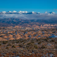
Ch-ch-ch-ch changes. David Bowie wrote of change in 1971, the year I was a freshman in college. For Bowie, it was a reflective song about stepping out on your own. I thought of that song and played it in my head as I sat down to compose this post. Not quite two months ago I made a major spontaneous change in my own life. I packed up a couple weeks of belongings and hit...
Learn More
Every year in early November I like to visit the Hickory Nut Gorge. It is on the eastern slope of the Continental Divide, and so a good thousand feet lower than most of the valleys in Western North Carolina. As such, the area is one of the last to experience glorious fall colors. You can count on the peak being somewhere between the 1st and the 14th. I made two trips...
Learn More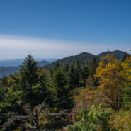
The first day of October I took a trip on the Blue Ridge Parkway to the high country north of Asheville, NC. The mountains here exceed 6,000 feet and the views seemingly go forever. It’s a captivating drive up, with plenty of pullouts so you can ooh and aah at the scenery. I tried to time my climb to catch some of the golden hour not long after dawn. My first stop...
Learn More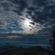
Those of you who have known me for awhile are aware that, since retirement, I have been what the National Park Service calls a VIP. Sounds pretentious, but really all it means is Volunteer in Parks. I help out at two, the Blue Ridge Parkway and Great Smoky Mountains National Park. Up on the Parkway I pick up litter, clean out storm drains, and do general tidying at one...
Learn More
Mount Parnassus is a mountain of limestone in central Greece that towers above Delphi, north of the Gulf of Corinth, and offers scenic views of the surrounding olive groves and countryside. Mount Parnassus is named after Parnassos, the son of the nymph Kleodora and the man Kleopompus. According to Greek mythology, this mountain was sacred to Dionysus and the Dionysian...
Learn More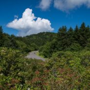
Does 2020 seem like a lost year so far? If you’re like me it has. I’ve been self-isolating since mid-March because of coronavirus. I only venture out to get groceries for my dad and myself. I have been hiking a grand total of once since March, and that time was only after entering Phase II of the grand reopening. Obviously soon after, positive cases began...
Learn More
While a walk around the 250 rooms of Biltmore House will thrill you with art and craftmanship and history and architecture, your visit to Biltmore Estate isn’t done until you get outside and explore the gardens and Conservatory, and the 20 miles of hiking and biking trails available. Because my brother and I were there on gift passes, we weren’t able to visit...
Learn More
Hard to believe I’ve lived in Western North Carolina for 15 years now, and had never visited the world famous Biltmore Estate. My brother managed to score a couple of gift passes, so we decided it must be about time to go after all these years. Now I might actually spring for the price of admission just to go back some day. Built by George Vanderbilt, heir to the...
Learn More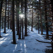
There was a snowstorm over Roan Mountain the last Friday in February, 2020. Seeing Roan Highlands covered in a blanket of snow is always a highlight of WNC winter. So on Sunday, March 1st I set out for this glorious destination high above the little town of Bakersville. It is quickly becoming one of my favorite things to do in winter. This makes three in a row now. As...
Learn More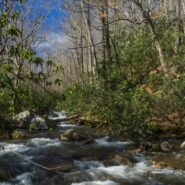
Jones Gap State Park sits on the Blue Ridge Escarpment in upstate South Carolina very near the state line with its neighbor to the north. Along with Caesars Head State Park, these two share an area known as Mountain Bridge Wilderness. The Jones Gap Trail follows the Middle Saluda River from the park visitor center along an old roadway built by Solomon Jones in the 1850s....
Learn More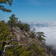
August 2005 saw the Carolina Mountain Land Conservancy (now Conserving Carolina) and The Nature Conservancy purchase a 1,568-acre tract of land south of Lake Lure known as “World’s Edge” for $16 million with the intention of transferring the land as the first to be added to the new Chimney Rock State Park. World’s Edge contains a mile-long set of steep...
Learn More
Tucked away in the northeastern corner of DuPont State Forest in Western North Carolina, Stone Mountain is the highest point in the state forest at 3,620 feet. Appropriately named for the exposed granite slab that traverses its summit, Stone Mountain offers a near 270° view of the surrounding terrain to winter hikers. Since the first time I went, nearly 12 years ago,...
Learn More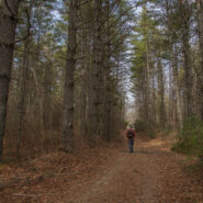
Located in the Guion Farm region of DuPont State Forest, this hike will take you to one of the lesser known, but equally memorable, of the exciting DuPont waterfalls. You are surrounded by majestic pine forest nearly throughout, with a walk along Grassy Creek for good measure. Most of the way is excellent double track surface, but that means you should listen for the...
Learn More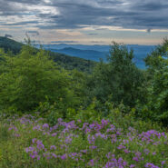
Cloudy and very windy. That’s what greeted me the morning of July 14, 2019 as I first stepped from my car at Pounding Mill Overlook (milepost 413). Those who know me also know that I’ve been picking up trash and otherwise maintaining this overlook on the Blue Ridge Parkway for each of the last 10 years. As I walked around to survey the accumulated trash since...
Learn More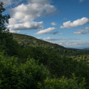
There’s not much more beautiful than the high country along the Blue Ridge Parkway in June. The days are long. The forest has completed its greening and the heath bushes are in bloom. If you catch the sights in the evening or very early morning you can even avoid the crowds. I’ve been on the shelf for a few weeks with an ankle injury while hiking, and was...
Learn More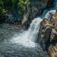
Located at milepost 316.5 along the Blue Ridge Parkway, Linville Falls moves in several distinct steps, beginning in a twin set of upper falls, passing through a small twisty gorge, and culminating in a high-volume 45-foot plunge. The Linville River flows from its headwaters high on the steep slopes of Grandfather Mountain and cascades through these falls as it begins a...
Learn More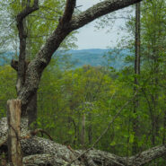
Sure, there are lots and lots of wildflowers in April at Whiteoak Sink and on the hillside at the Townsend Y to make this hike seriously entertaining. But there is a lot more to the Schoolhouse Gap/Chestnut Top combination hike than abundant spring flowers. The views into Townsend from the Chestnut Top ridge are notable, and the forest that surrounds you throughout is...
Learn More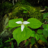
With the perpetual crowd at The Sinks location in the Smokies, it was surprising to me that hardly anyone hikes this trail that starts at the popular waterfall along Little River Road. Another surprise was the abundance of spring ephemeral wildflowers found along the trail. I counted more than a dozen varieties, and plenty of each. Once you reach Meigs Creek, it’s...
Learn More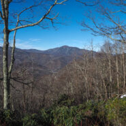
The Blue Ridge Parkway frequently closes for snow and ice in late Fall and Winter. While it’s disappointing you can’t traverse the roadway by vehicle, the fun news is that you can still access your favorite overlooks on foot, without any traffic. It is so peaceful. Most access roads to the Parkway are maintained during snow season, so you can get to the...
Learn More
Few places in the Southern Appalachians are more scenic than Max Patch along the Appalachian Trail on the state line between North Carolina and Tennessee. Even more so when the magic of Fall coloring surrounds the mountaintop. You can see my complete trail report for Max Patch and Buckeye Ridge, and learn about an unexpected adventure I had a few years ago on my first...
Learn More
Like a child anticipating Christmas, this year has had us waiting… waiting… waiting for the leaf peeping season to begin. Combine a very wet summer with a September where the warmth never ended, and it’s like the year that fall never arrived. This day, October 12, 2018, was the first day all autumn where the overnight temperature dropped into the...
Learn More I am Jeff Clark, founder of Internet Brothers, producer of this blog, and passionate about hiking. I live in Western NC near the Blue Ridge and Great Smoky Mountains. Pisgah and Nantahala National Forests are just out my door, so the content will focus on these areas, but let me know what you would like to see on the site.


Copyright © 2011-2023 Internet Brothers. All Rights Reserved. ISSN 2324-6057
Designed by Elegant Themes | Powered by Wordpress | Logo by Design Aspirations