
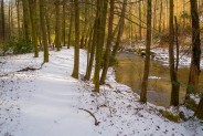
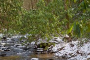
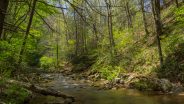
This hike is found in a remote corner of the Green River Game Lands near Saluda, NC that enables you to enjoy beautiful waterfalls. Little Bradley Trail follows Cove Creek along its path to an eventual meeting with Green River, but before it gets there, it tumbles over the three-tiered cascade at Little Bradley Falls. I happened to catch it a couple days after a snowfall, so the white enhanced the scene even more. This hike occurred on Friday, January 31, 2014 beginning at 11:30AM and ending about 2:00PM. My plan was to take the Little Bradley Trail to Little Bradley Falls, then return. However, I was stymied by a creek crossing. Not to fret though. I learned of an alternate access that requires a little daring.
Hike Length: 4.8 miles Hike Duration: 2.5 hours
Hike Rating: Easy, but you will have to get your feet wet. Blaze: Red
Elevation Gain: 910 feet Hike Configuration: Out and back
Trail Condition: The trail is in good condition, but not well marked.
Starting Point: Parking area along Holbert Cove Road.
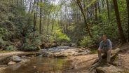
Trail Traffic: I encountered one other hiker on this winter weekday, thankfully.
How to Get There: Take I-26 to the Saluda, NC exit. Turn north (away from Saluda) on Holbert Cove Road and go 3.3 miles. At the bottom of the hill, there is a pullout on the left side of the road with enough room for 8-10 cars. The trailhead is across the road, and across the culvert.
I made a series of mistakes while hiking this trail, but still managed to find my way to Little Bradley Falls… with the help on another hiker who happened to be out with his poodle. My first mistake was right at the start. The trailhead is across Holbert Cove Road from the parking area, on the other side of the culvert where Cove Creek crosses under the road. There is a false trail that parallels the creek, and looks very inviting. That’s the one I took.
However, after about 300 yards, it just dead-ends. I was able to get to the actual trail by climbing a very steep hillside, but that really isn’t the way you want to go. So let’s go back to the beginning, and I’ll describe what to look for. At the trailhead there is a pink ribbon wrapped around a tree. It is crucial to locate that ribbon. Once you have it, you will see the false trail (my mistake) to your right, and the correct trail going slightly uphill to the left of the ribbon. They say there are red blaze markers on trees, but I never saw one. I think they must be badly faded.
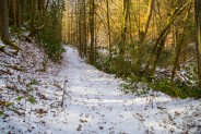
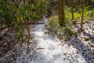
Anyway, if you take the correct path at the beginning you will find a quite obvious footpath that is easy to follow. There are a few downed trees along the way that you’ll have to climb over, or under, but for the most part this trail is notably discernible. And with about an inch of snow on the ground, I was able to see the fresh boot prints and paw prints of another hiker and his dog.
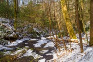
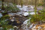
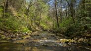
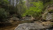
The trail climbs gradually above the creek, perhaps 70-80 feet higher, but maintains a direction that follows Cove Creek. Then it descends again to creek level. After about half a mile, I came to a creek junction (not realizing it was also a trail junction) and made my 2nd mistake. The trail appeared to me to make a natural curve to the left (east-southeast), so I followed. The new creek was smaller, but no less scenic with a layering of snow covering the rocks that poked above the stream.
This was where the other boot prints went, so how was I to know I had taken a wrong turn. I continued in a southeasterly direction for another half mile (look at the map above to see my side-trek), and then I encountered the other hiker coming toward me. I saw his little dog first, followed by the hiker about 50 feet behind. I asked if this was the way to Little Bradley Falls, and he answered, “No, you made the same mistake I did the first time I was here.”
He described the creek junction and said I made a wrong turn there. I needed to bear right and cross the creek instead of bearing left as I had. He went on to add that it really wouldn’t do me any good anyway because there was a 2nd creek crossing further along that was impassable on this day because of deep water and ice.
However — and this is what saved the trip for me — he said there was an alternate means of getting to the other side of Cove Creek. He said if I went back to my car, drove up Holbert Cove Road to the top of the hill, there was a way of descending along the boulders that support the roadbed to the trail. He said it isn’t easy, but it is a way to avoid the creek crossing. So with that information in hand, I thanked him, and continued a little farther up the smaller creek just to see what was there and take some photos.
Giving the other hiker about 15 minutes to move on ahead, I eventually turned around and went back the way I came, looking again for the creek junction. Once I reached it, I could easily make out the correct trail. It makes a rock hop across the smaller creek and continues through the forest paralleling the larger Cove Creek. Presumably there is a red blaze somewhere at this trail junction, but again, I never found one. Perhaps the markings are more visible in summer.
The wrong trail that I took doesn’t have a name to my knowledge, but it was a nice addition to this hike if you want to lengthen it some. I left the track on the map above with a waypoint at the junction so you can see where it is.
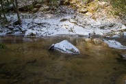
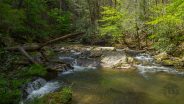
Once I was back on Little Bradley Trail, and across the creek, it was about 10 minutes to the 2nd creek crossing. This one was an entirely different matter. Cove Creek is about 30 feet wide here, and on this day was about knee high in depth. There are rocks across, so conceivably you could rock hop if conditions were just right, but as the other hiker had mentioned, today those rocks were icy. With the temperature hovering right around freezing, there was no way I was taking off my boots and wading through.
So I made an impromptu plan to head back to the car and look for the boulder scramble further up Holbert Cove Road. From my vantage point alongside Cove Creek, I scouted the hillside on the other side to get my bearings, and began the return to the trailhead. I was back to my car in about a half hour, and driving up the road looking for a place to pullout and park at the top of the hill.
There are a couple places, actually, each big enough for a car or two. The climb down the hill wasn’t easy — it was slippery from both wet leaves and ice — but I made it safely down to the trail. First, I backtracked to the creek to look at the crossing from the other side. I had definitely made the right decision to not cross. Perhaps I’ll be back in warmer weather to try the crossing in bare feet.
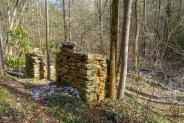
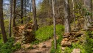
Any ol’ way, I was back on Little Bradley Trail and on my way to the falls. The trail along the way continues to follow Cove Creek, but now on the right side. It passes some old stone ruins and a series of rock outcroppings that were covered with icicles. There is one tricky spot where the trail traverses another boulder field that was placed to help shore-up Holbert Cove Road, but it is still a well-defined and easy hike of about 20 minutes to Little Bradley Falls.
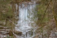
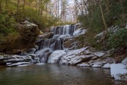
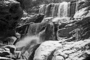
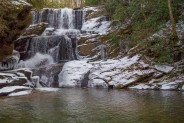
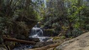
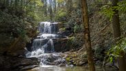
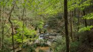
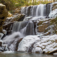
I kept listening for that unmistakable sound of rushing water that hints a waterfall is near, but until rounding a bend, it hadn’t been obvious. Suddenly, there it was. With a large plunge pool that is surrounded by rocks, Little Bradley Falls is about 35 feet tall, and cascades over three tiers. This particular day, there seemed to be quite a bit of water plummeting over the precipice.
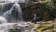
There are plenty of locations for photographs. The rocks that surround the basin work for building a level tripod platform, or for sunning yourself on a hot summer day. During warmer, and safer times, there is a trail that goes to the top of the falls and alongside enabling multiple angles of view.
There were a few icicles left from the deep freeze we experienced earlier in the week, but for the most part Little Bradley Falls was free-flowing on this day. I spent close to half an hour enjoying the sights and sounds, and scouting out points of view for sometime in the future when the rocks aren’t icy. Since I was alone on this hike, there was no sense taking unnecessary risks.
After viewing the falls, I returned the same way I had come in. The lone problem with coming down the hill from the road is that it is very, very steep going back up. I was on all fours pulling myself up by roots and saplings. It’s only about 100 feet of climbing though, so I made it, albeit with my lungs and thighs aching.
To summarize, Little Bradley Trail is a nice shortish hike to a very scenic waterfall if you don’t make all the same mistakes that I did on my first visit. Be sure to look for the pink ribbon. Be sure to cross the smaller creek at the creek junction, and be sure to go when it’s safe to make the second creek crossing. You can cut it down from a three mile round trip to just one mile if you come down the boulder field from the road, but then you would miss the nice scenery along Cove Creek. I am curious to see the trail and the falls when leaves are on the trees and the rhododendron are blooming, so I will be back.

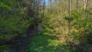
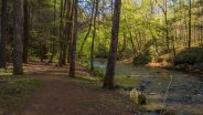
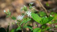
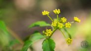
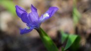
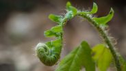
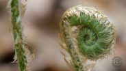
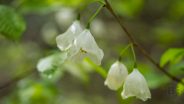
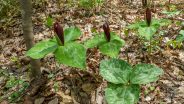
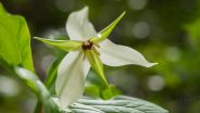
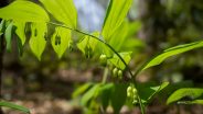
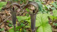
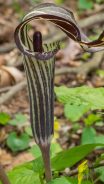
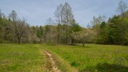
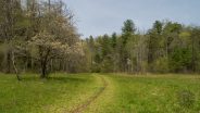
Update April 13, 2016: I made another visit to Little Bradley Falls as the forest was greening, and was delighted to find a plethora of mountain wildflowers, including the elusive jack-in-the-pulpit. As you peruse the new photo gallery below, compare and contrast the change in seasons from the photos in the gallery above. I also planned ahead for the wet crossings of Cove Creek and brought my water shoes. Wading knees deep in the fresh chill of the mountain stream was delightful.
When I was finished on the south side of Cove Creek, I went out the trail on the north side of the road to scout the path to the other Bradley Falls for a future visit. It also looks quite interesting, so expect to see me back soon with a complete trail report to follow. In the meantime, enjoy the new pictures! Feel free to leave your comments below the thumbnails.


The following are paid links. As an Amazon Associate I earn from qualifying purchases.
 I am Jeff Clark, founder of Internet Brothers, producer of this blog, and passionate about hiking. I live in Western NC near the Blue Ridge and Great Smoky Mountains. Pisgah and Nantahala National Forests are just out my door, so the content will focus on these areas, but let me know what you would like to see on the site.


Copyright © 2011-2023 Internet Brothers. All Rights Reserved. ISSN 2324-6057
Designed by Elegant Themes | Powered by Wordpress | Logo by Design Aspirations


That is a gorgeous picture of the falls – and your blog is a gem of info on NC that I will need to remember when I find myself on that side of the country!
Thank you for the kind words Denise. I’m sure you will love WNC when you come to visit.
I’ve taken the other trail off of Holbert, and gone to the top of Big Bradley Falls. It’s a rough hike in warmer weather, with two difficult crossings of the creek, but the falls are among the most spectacular in this area. There’s a 15 foot rope climb down and then back up a vertical rock face. The top of the falls can be quite dangerous, with past fatalities. Still worth the effort, especially after a heavy rain.