
Northeast of Mars Hill, NC, the Big Bald Range straddles the Tennesssee/North Carolina border and marks the boundary between Pisgah and Cherokee National Forests. The Appalachian Trail (AT) follows the state line, as it does for nearly all its length between these two states. The destination for this hike is 5,516 foot Big Bald Mountain, another of the grassy balds that are common in this area. You can make your day as long or as short as you like by exploring the AT in either direction. At least be sure to also check out Big Stamp, another of the balds with a lengthy grassy ridge. This hike occurred on Tuesday, July 30, 2013 from 8:45am to 11:35am. Our plan was to take the Appalachian Trail over Big Stamp and Big Bald, and hike the AT for an hour or so.
Hike Length: 4.1 miles Hike Duration: 2.75 hours Blaze: White
Hike Configuration: Out and back Elevation Gain: 670 feet
Hike Rating: Mostly easy, but the summit climb is moderately strenuous.
Trail Condition: Excellent, the trail angels take good care of the AT.
Starting Point: Trailhead at the end of Big Bald Mountain Road in Wolf Laurel.
Trail Traffic: We encountered two other pairs of hikers.
How to Get There: From Asheville, NC or Erwin, TN take I-26 to NC exit 3 and follow the signs to Wolf Laurel Ski Resort. Check in with security at the Wolf Laurel gate, then proceed straight on Wolf Laurel Road for 1.7 miles. Turn left on Big Bald Road and continue up the mountain for two more miles (the last 1.3 miles will be gravel). Park in the cul-de-sac at the gate and proceed on foot past the gate for 1/4 mile where the gravel road will intersect with the AT. Big Stamp is on the right and Big Bald is on the left.
If it’s a long section hike on the Appalachian Trail you’re looking for, you can access Big Bald Mountain from Sams Gap — where I-26 crosses the North Carolina/Tennessee state line. It’s a 13-mile round trip from there. From the northeast, you can also access the AT from Highway 19W, but the distance is about double.
The best way to get to Big Bald and Big Stamp is through the Wolf Laurel Resort community. From there, it’s little more than half a mile to the Big Bald summit. There’s just one hitch, though. Wolf Laurel is private property, with an entrance gate monitored by a security guard. So, you need to make arrangements with the resort’s administrative office before you go. Otherwise, you will be turned back at the gate.
Provided you’ve done your homework, once you clear security, you’ll drive through the Wolf Laurel community that includes a ski mountain and a country club. Follow Wolf Laurel Rd. to Big Bald Mountain Rd., then go all the way to the dead end. Park at the cul-de-sac and begin your hike through the gate on the gravel road. From there it is 1/4 mile to the Appalachian Trail.
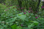
For Meanderthals, this was another foray to the state line on the AT. It seems we’ve done quite a bit of exploring on the high mountain balds this summer, including Unaka Mountain earlier this month, and Roan Highlands during peak flowering season last month. Speaking of wildflowers, there was still quite a bit of bee balm blooming in this Big Bald area, of multiple colors.
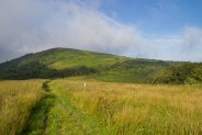
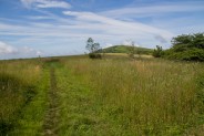
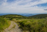
Where the Appalachian Trail crosses the gravel road you have a choice. You can go left and immediately climb Big Bald, or you can go right and climb Big Stamp. We chose the latter. The sun was still low in the sky, so there was a delightful golden glow on the waist-high native grass that lined the trail. About once a month, trail angels come to the grassy balds with lawnmowers and string trimmers to keep an 8-foot-wide swath cropped, and easy to follow.
It was early enough that the morning fog was still hanging around — quite the sight watching it waft over and around the balds. Since long-distance viewing was muted by the fog, we decided to explore eastward on the trail, and come back to the balds later, once the fog had lifted. We encountered another pair of hikers, coming down from Big Stamp.
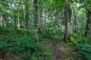
The morning dew tickled our legs as we crossed Big Stamp bald and entered the forest. The trail began a gradual descent, heading to the next gap between ridges. The forest here is primarily birch and beech. There was still mud on the trail from all the rains of July. This has been an incredibly rainy season in the Smoky Mountains with more than a foot of precipitation above the annual norms. At least there were no creek crossings today.
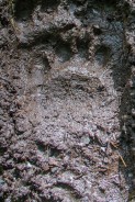
One thing the mud does is enable clear imprints of wildlife tracks. The unmistakable cloven hooves of deer were quite evident, as was the impression of a juvenile black bear. This area would also be a haven for wild turkey, so keep your eyes and ears peeled.
Half a mile into the forest we passed the spur trail to the AT Big Bald Mountain Shelter, and another quarter mile beyond that we came to a water source for the thru-hikers. If you plan on spending a few days in the Big Bald Range, keep these in mind.
We went just five minutes past the spring, decided not much was changing in the way of scenery, so we opted to reverse track and see if the fog had lifted around the balds. Sure enough, when we popped back out of the woods on the eastern end of Big Stamp, the low-lying fog had given way to that vaporous haze that gives the Smoky Mountains their name.
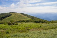
The AT takes a twisty path up the northeastern flank of Big Bald Mountain, cutting its way through shoulder-height berry bushes and other ubiquitous scrub. The trail itself is well maintained, albeit somewhat rocky. We didn’t encounter any areas of overgrowth on our climb to the summit.
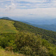
It’s about a half mile from the gap between Big Stamp and Big Bald to the summit, climbing just under 600 feet along the way. It isn’t particularly difficult, so you should give this one a try, no matter your fitness level. The panoramic views from the top are definitely worth the exertion to get there.
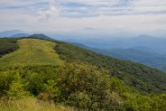
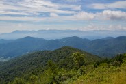
We found a nice rocky outcropping on the east side of the summit for lunch, with a great view of Big Stamp and the surrounding Smoky Mountains. That’s the photo at the top of this post. Click it for a larger view. From here we could pick out Unaka Mountain to the northeast, with the town of Erwin below. The Tennessee tri-cities area is way off in the distance northward, and Roan Mountain is quite evident beyond and east of Unaka.
To the southeast are the imposing Black Mountains, including Mt. Mitchell. Despite the haze, the vistas were pretty good on this day. I suspect in winter you can probably see for 50 miles or more from Big Bald. I will keep this one in my tickler file for a December or January hike.
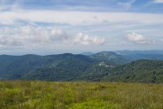
The Wolf Laurel community is perched on the hillsides to the southwest. Homes hug the rugged terrain. The ski mountain stands above the small village. I’ve never been skiing, so I can’t offer any info about conditions here. There look to be five primary slopes.
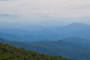
To the north and west is Tennessee, with more mountains as far as the eye can see. As you would surmise from the name, the rounded summit of Big Bald is quite large, covering perhaps a hundred acres. While we were enjoying lunch, an elderly couple joined us on the summit. Probably near 80, they made the climb with no problem. So see, you can do it.
The Big Bald Mountain gravel road comes all the way to the summit, so we decided to go back down that way. The road takes more of a northerly track off the mountain, whereas the AT is easterly. They both eventually end up at the same place, in the gap between Big Stamp and Big Bald.
To summarize, Big Bald is a great spot for those 360° panoramic views that are so photo friendly. You really get an idea of the beauty of the surrounding Smoky Mountains in every direction. If you only have a short amount of time, this is a quick hike to the summit of Big Bald. If you wish to make a day of it, take the Appalachian Trail in either direction for as far as you want to explore. Remember that Wolf Laurel is a private community, so if you access Big Bald through there, you must call ahead.


The following are paid links. As an Amazon Associate I earn from qualifying purchases.
 I am Jeff Clark, founder of Internet Brothers, producer of this blog, and passionate about hiking. I live in Western NC near the Blue Ridge and Great Smoky Mountains. Pisgah and Nantahala National Forests are just out my door, so the content will focus on these areas, but let me know what you would like to see on the site.


Copyright © 2011-2023 Internet Brothers. All Rights Reserved. ISSN 2324-6057
Designed by Elegant Themes | Powered by Wordpress | Logo by Design Aspirations
