
Most of the attention in Linville Gorge is focused on the northern features. There are more trails, higher peaks, and family recreation areas. But the south gorge is every bit as compelling and beautiful, with spectacular panoramic views up the gorge and westward to Pisgah National Forest and the Blue Ridge Mountains. Shortoff Mountain is a thousand feet lower than its more famous brethren to the north — Tablerock and Hawksbill — but it also offers unobstructed views of Lake James to the south. Hiking this trail is a sweet shortcut to the sheer cliffs on the rim of Shortoff Mountain. They stand high above the Linville River below, so watch your step, but enjoy the scenic gorge that surrounds you. This hike occurred on Thursday, October 6, 2011 from 9:55am to about 1:40pm. The plan was to take the Shortoff Mountain Trail from Wolfpit Road to the summit of Shortoff Mountain and wander around on the plateau checking out the scenic views of Linville Gorge. Return would be via the same trail.
Hike Length: 4.4 miles Hike Duration: 3.5 hours
Hike Rating: Moderate, strenuous but short Blaze: White on MtS
Elevation Gain: 1320 feet Hike Configuration: Up and back
Trail Condition: Rocky and trenched going up, very good on top
Starting Point: The Shortoff trailhead is at the end of Wolf Pit Road
Trail Traffic: We encountered two campers on the summit of Shortoff
How to Get There: East of Marion, NC from Hwy 70 take NC 126 north at Nebo. Go about 5 miles, past Lake James State Park and across the Linville River, then turn left on the gravel Wolf Pit Road. Wolf Pit dead ends after 2.5 miles at the trailhead.
View Shortoff Mountain Trail, Linville Gorge Wilderness in a larger map
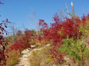
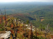
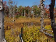
Drought induced fire ravaged Shortoff Mountain twice in the past decade, first in 2002, then again in 2007. It’s a double-edge sword however. The blackened tree stumps and remains are tolerable because the vistas are wide open. Without the tree cover, everything that was previously not visible along the trail now comes into view. The forest is doing a good job of regenerating already, and we happened to hit it just as the sumac and other low-lying ground cover were displaying their richest autumn regalia. Without the forest cover though, be sure to be prepared for bright sunshine with sunscreen and a cap.
All of the 1300 feet of elevation gain on this hike occurs in the first mile, so it is a steady upward climb right from the trailhead. We began to see evidence of those fires almost immediately, and also the erosion that occurred before revegetation. The trail itself has become a drainage channel from the mountain above, so it is very rocky and beginning to trench in spots. I would definitely recommend wearing thick soled hiking shoes or boots so your feet can withstand all the rocks.
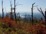
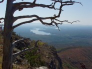
After about 15 minutes of climbing, be sure to start looking behind you because Lake James and the surrounding valley are there to behold. At first we could see the fingers of the Linville River backed up behind the dam. The higher we climbed, more of the full expanse of the lake came into view, including the section behind the Catawba River Dam. The South Mountains are visible beyond the lake, and the massive edge of the Blue Ridge Escarpment appears to the west.
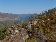
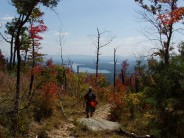
As we cleared the few stands of trees near the bottom that were spared in the fires, the trail began to get steeper; so the switchbacks started. Nearly all the rest of the upward climb is done on switchbacks — a good thing — because it’s a significant incline. After about a half mile of climbing we reached the beginning of the rocky outcroppings, and our first views within the south end of Linville Gorge itself. These outcrops are like benches; nice places to sit and rest for awhile. The thread that is Linville River is visible below, but mostly guarded by the thick forest along the river’s edge.
The lower trail goes through one more series of switchbacks before reaching the plateau. You’ll know you are there when you pass a small piped spring along the right side of the very narrow trail. The spring water immediately drops off the left side of the trail to the depths below. Just around the bend is a short spur trail to the first cliff overlook. It’s a long way down, so be very careful. There are plenty of toe snags to trip and stumble — not a good place to do that. From this first cliff we could see the western edge of Lake James to the south, and northward the very large rock wall along Shortoff Mountain’s western rim that is home to the peregrine falcons. Rock climbers love this cliff wall, but it is closed to climbing during the falcon nesting season from January 15 – August 15.
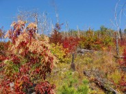
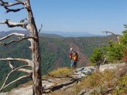
 The 2883′ top of Shortoff Mountain is a large plateau. The trail alternates between following the cliff edge, and plunging into the young, rejuvenating forest… and it’s flat. Whew, what a relief! On this early October day we were treated to excellent autumn colorings from the ground cover and wildflowers. From purple daisies to the bright yellow of the goldenrod, the red sumac and the evergreen pine, all topped by a brilliant blue sky that was crystal clear. It was a visual Fall delight.
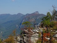
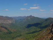
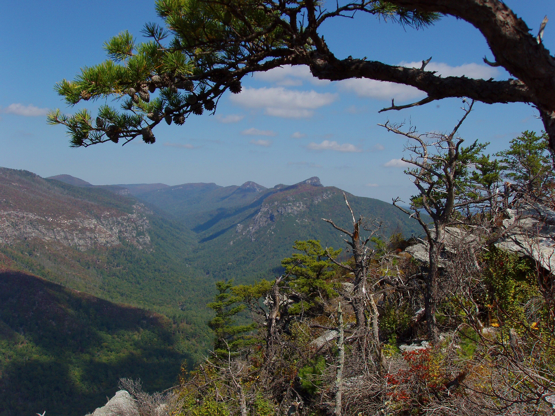
Pausing for a few breaks on the way up, it took us an hour and 20 minutes to reach a very large opening along the western cliff face that gave us our first complete view of the full gorge northward. There is a rock rim about 50 feet long with bench like terraces that looked exactly like lunch. We dropped our packs, pulled out our sandwiches and fruit, and sat in awe of the stellar view of Tablerock and Hawksbill Mountains to the north. We could make out the river artery 1300 feet below and Linville Mountain along the western flank. Further north up Jonas Ridge was Sitting Bear Mountain and the gaps between mountains where the trails down to the river begin.
In the near distance we could see The Chimneys on the southern side of Tablerock Mountain and the sharp slope down to the North Carolina Wall, another haven for rock climbers. We talked fondly of that really windy day when we hiked down that slope to peer into The Amphitheater, as well as looking south at the cliffs of Shortoff where we were now enjoying our lunch. I love the perspective I am developing by seeing all the features of Linville Gorge from each other; and there’s so much more yet to explore as there are 39 miles of trails within the wilderness. I’ve only done about half so far.
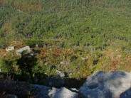
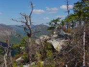
 After getting sated and re-energized by lunch, we continued our northward trek. The famous Mountains to the Sea trail joins the Shortoff Trail on the plateau and is identified by white blaze circles on trees. I was frankly surprised to see the blaze marks because I didn’t think they were allowed in designated wilderness. We passed two camping areas, well protected within the pines that were spared by fire. We saw a camping couple at the first, still enjoying the hammocks they had deployed amid the pines. The 2nd camping area had another overlook to explore. Following a bit of rock scrambling, we found a nice view of the west rim of the gorge.
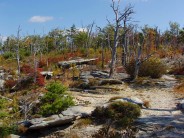
The trail curls toward the center of the plateau from this point and becomes a nice stroll through young forest. There wasn’t any particular other destination for us, so it just became a matter of when to turn back, as eventually the trail winds tortuously down into Chimney Gap. We were quite surprised to come upon a marshy area with a small pond about 30 feet in diameter. It was quite scenic, with tall grasses around, and a clutch of colorful deciduous trees behind it. This seemed as good a place as any to turn around. If we missed the best overlook, or some other awesome sight by not going far enough, perhaps Lori Beth from Hiking the High Country can give me a swift kick in the behind.
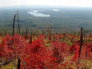
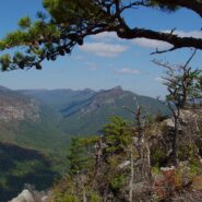
On the way back we stopped at what I thought was the best overlook. The campers from before were up and about now and packing their gear away. Being a Meanderthal, I boldly asked if it would be okay to interrupt their solitude and walk to the overlook through their campsite. They were extremely gracious, even joking that they didn’t own the wilderness. I’m really glad we stopped. This was the best and closest view of the giant massifs to the north up gorge. We also happened to catch a trio of buzzards floating high above on the wind currents checking to see if we old farts might be a meal. Joe Miller in his 100 Classic Hikes in North Carolina thinks this might be one of the best views in all of NC, and it is certainly right up there. Stunning!
We thanked the campers again on the way out and headed back south. We stopped one more time at all the overlooks to get some more pictures and marveled for the umpteenth time how majestic and awesome Linville Gorge is. It happens every time I go. Maybe one day I will move closer so it isn’t a two hour drive. On the way down the sun was higher in the sky, so we weren’t looking directly into it at Lake James like we were on the way up. The afternoon sun seemed to make the foliage even brighter and more colorful than before. While the fires left ugly scars on the mountain that will last for decades, they also enabled views that didn’t exist before when there was a forest canopy. I think an even trade.
I have yet to have a bad experience in the Linville Gorge Wilderness. The scenery and atmosphere are awe-inspiring whether hiking along the ridges and cliffs on the east rim or dropping down into the gorge for whitewater river adventures from the west. Shortoff Mountain is no exception. It is a wonderful, and short hike, enabling us to take our time and really enjoy the grand vistas. This trail sure is a whole lot easier than wandering through Chimney Gap from the north to get there. My special thanks to Lori Beth de Hertogh for turning me on to this quick and sweet shortcut to Shortoff Mountain.
For additional tips, information, and useful links, please visit the following: Tips on Linville Gorge

The following are paid links. As an Amazon Associate I earn from qualifying purchases.
 I am Jeff Clark, founder of Internet Brothers, producer of this blog, and passionate about hiking. I live in Western NC near the Blue Ridge and Great Smoky Mountains. Pisgah and Nantahala National Forests are just out my door, so the content will focus on these areas, but let me know what you would like to see on the site.


Copyright © 2011-2023 Internet Brothers. All Rights Reserved. ISSN 2324-6057
Designed by Elegant Themes | Powered by Wordpress | Logo by Design Aspirations
Great stuff, Jeff! The Gorge is on my list for Fall.
Great trail report. Looks like you guys have some wonderful color down there right now!
Karl
Nice report. Enjoyed the pictures – #5 is pretty cool where you can see the treeline on the ridge below from the fire.
Hi David, Indeed it was cool. It was an enjoyable hike from start to finish.
Hi Jeff,
No swift kicks in the rear are necessary; you stopped at the perfect place! 🙂
By the way, we just got back from some excellent hiking/camping terrain in the Red River Gorge in Kentucky; you might head out that way sometime.
Hi Jeff, thanks for the great post. I am visiting the Linville Gorge/Lake James area this summer with my kids. Last summer we hiked to the top of Looking Glass Rock and that was an exceptional view. I’d love to do something like that again. But some of the ridges you describe sound dangerous, and I can’t find any info on this trail, so I’m not sure if it’s too treacherous for kids? Any thoughts you might have are helpful.
Hello Tish. I think the age of your kids is germane to the consideration of this hike. There definitely are sheer cliffs that fall a long way. I wouldn’t think it advisable to bring kids younger than about 8 years of age or so. You know your own kids best, their capabilities and their comprehension of potential danger.
I’m sure you remember the overlooks on Looking Glass Rock. They drop a long way, but they aren’t quite as sheer. They’re more rounded. Along the Shortoff Trail above Lake James the cliff edges are sheer. There is little room for error. Mistakes would be fatal.
I don’t want to scare you away from an absolutely delightful hike, but I do want to be realistic. If your young ones need to age a little more, save this beautiful hike for a few years down the road. Linville Gorge will be there. It always will be.
I’m okay with the heights if the trail is wide enough, but I’d hate to be so worried about missteps to be able to enjoy it. Perhaps we’ll stick to Tablerock instead this time around. From what I’ve read, that’s a relatively easy hike. I’m so looking forward to exploring this area.
How far into the hike before you have a place to hang a hammock? I did the Southern Loop last year but can’t remember.
Kevin, once you reach the plateau you are mostly out of the burn area, so you are back in among trees that are large enough to support a hammock. Keep your eyes peeled along the cliff side for scattered primitive campsites. There are a few convenient places that also happen to have excellent views of the gorge.