
Sitting right along the Tennessee/North Carolina border in the far northeast corner of Great Smoky Mountains National Park is an enjoyable section of forest and creek side trails that navigate the Big Creek area of the park. The Appalachian Trail goes through the area, as does the Benton MacKaye Trail, named for the planner of the AT. There are mountains in the region as well. Mt. Cammerer and Mt. Sterling are popular hikes with splendid views, but on this day my brother and I wanted to do some creek hiking. This hike occurred on May 18, 2011 beginning at 9:00AM and ending about 3:30PM. Our plan was to tackle two different trails on this day. First, we wanted to do the Chestnut Branch Loop. It starts out at the Big Creek Ranger Station, climbs on Mt. Sterling Road for a bit, joins the Appalachian Trail at Davenport Gap, then returns to the ranger station via the Chestnut Branch Trail. The 2nd portion of the hike was on the Big Creek Trail with Mouse Creek Falls being a four mile round trip.
Hike Length: 9.4 miles Hike Duration: 6.5 hours
Hike Rating: Moderate Blaze: White on the AT Elevation Gain: 1680 feet
Hike Configuration: Loop on Chestnut Branch, Up and back on Big Creek
Trail Condition: Excellent, well maintained Starting Point: Big Creek Ranger Station
Trail Traffic: We encountered five through hikers on the two mile stretch of the Appalachian Trail, but no others on the Chestnut Branch Trail. We saw only one other hiker on the way to Mouse Creek Falls, but on the return we passed six folks from the campground who were out for a stroll on Big Creek Trail.
How to Get There: From I-40, take the Waterville Road Exit (Tennessee #451). Turn left after crossing the Pigeon River into North Carolina and proceed 2.3 miles to an intersection with Mt. Sterling Road. Continue straight, the ranger station is on the right.
May is rainy season in the Smokies, and we got plenty of it in the days leading up to this hike, so we expected a wet trail. Our original plan was to climb Mt. Cammerer, but the rain and thunderstorms in the forecast led us to look for something a little easier to abandon if the weather took a turn for the worse. My brother and I got a dawn start for the 90 minute drive from my home in western NC to the Big Creek Ranger Station. It’s really more of a ranger residence and office than a visitor center, but there is plenty of parking and a pay phone.
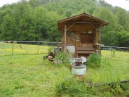
We chose to start with the Chestnut Branch Loop first, opting for a counterclockwise direction that would start going north on Mt. Sterling Road. At the corner of Waterville Road and Mt. Sterling Road is a plaque that tells the story of Francis Asbury, a Methodist bishop who traveled the area to spread the word at the turn of the 18th-19th century. What I found of more interest, however, was the “horse stuff” shack. There was a very old washing machine and wash basin, and well, horse stuff (yes, there’s a photo in the gallery down below). It kinda made sense, as we came upon a horse pasture and even a few horses another few hundred yards up the road.
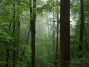
After a mile and a half, the Appalachian Trail crosses Mt. Sterling Road at Davenport Gap. We headed off to the left on the AT toward Newfound Gap. It’s a moderate climb of 1100 feet over the next 1.9 miles to the junction with Chestnut Branch Trail. The trail goes through a very thick forest that is super green in mid-May, and quite misty on this day. White pine, hickory, birch and several varieties of oak stand near 100 feet tall and provide a constant shade for the ground cover below. I couldn’t make up mind if I was hot or cold on this muggy, 50 degree day. I changed layers a few times.
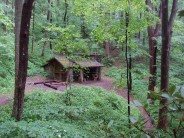
We didn’t see any wildlife other than a few squirrels, but the tree frogs did come out to play. We saw a few mountain laurel in bloom, but most were just getting their buds. About half way up the AT, there is a spur to the Davenport shelter, one of hundreds along the trail that help the through hikers each night. Past the shelter, we began to encounter some of the through hikers on the AT. Stern of purpose, with rugged determination, we received little more than a nod from each one we passed. At the top of the ridge we reached the junction to Chestnut Branch off to the left. The AT continues on to Mt. Cammerer.
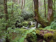
 There was a nice big log at the trail junction, so we stopped for an early lunch. As we were munching, another through hiker came along and actually stopped to chat. He told us it had snowed on Mt. Cammerer the day before, the day we originally planned to climb it. Apparently we made a good call on changing our plans. The two mile Chestnut Branch Trail begins heading downhill immediately. It winds through an absolutely beautiful bright green forest, and crosses a few small streams. About half way down the mountain, the trail meets Chestnut Branch and turns to the left, or east. This is a nice forested creek with several cascades and lots of great spots for pictures. The rocks and trees along the creek are covered in a thick carpet of moss that makes for a soft cushy seat to rest, listen, smell and enjoy. I’m normally a mountain view kind of a guy, but these old growth, creek side trails aren’t too shabby either. It’s a total of about a full mile alongside Chestnut Branch, and after some three hours, we returned to the ranger station.
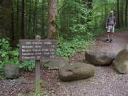
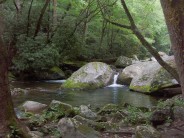
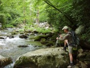
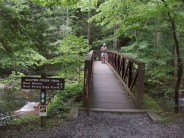
It’s a half-mile drive from the ranger station up Big Creek Road to the Big Creek campground and trailhead. Our destination up Big Creek Trail was Mouse Creek Falls, two miles away. The trail is actually an old rail bed left from a logging operation a hundred years ago — so it is nice and wide — three hikers could walk side-by-side. The first half mile climbs gradually past the campground and Big Creek below and on the left. The total climb to the falls is a steady, easy 580 feet. The goodness starts when the trail and the creek converge. For the final mile and a half to the falls, the trail is just off the creek side and there are a dozen or more prime spots to stop. I was tempted to dangle my toes in the fresh, chill water, but chill was the operative word there.
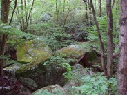
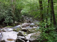
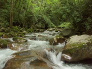
 The creek bed is strewn with rock and very large boulders, some no doubt displaced by the 20th century logging, others washed down from far above in the Smoky Mountains. My guess would be this is an ideal play area for teens during the hot summer. When the water warms up, there are plenty of natural pools for swimming, and rocks to jump and declare, “look what I can do.” 1.5 miles up the trail is a feature they call Midnight Hole, a large natural pool that sits beneath a short, but intense waterfall. We joined up with another fellow who was staying at the campground and was out for an easy afternoon stroll. We asked how much further to Mouse Creek, and he assured us not much.
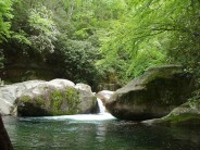
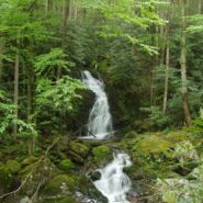
Mouse Creek flows into Big Creek in spectacular fashion by dropping 45 feet over the Mouse Creek Falls. There is a bench that sits on the trail side of Big Creek that offers a nice view. The photo at the top of this post is that view. Being the Meanderthal that I am, I decided to head down the very steep, rocky trail to the base of the falls at creek level to get some pictures. I usually carry a pruning saw in my pack that I use to help with trail maintenance, especially in the spring when there is a lot of trail debris from the hard winter. Unfortunately on this day, I didn’t have the saw secured to my pack with the carabiner. When I reached the base of the falls and was scrambling over the rocks for the ideal spot, I tilted forward just enough so the saw came tumbling out of the sleeve in my pack, and into the rushing water below. Before I could make a desperate lunge, it was already 20 feet downstream and picking up velocity. So much for that… but I did get some photos.

The following are paid links. As an Amazon Associate I earn from qualifying purchases.
 I am Jeff Clark, founder of Internet Brothers, producer of this blog, and passionate about hiking. I live in Western NC near the Blue Ridge and Great Smoky Mountains. Pisgah and Nantahala National Forests are just out my door, so the content will focus on these areas, but let me know what you would like to see on the site.


Copyright © 2011-2023 Internet Brothers. All Rights Reserved. ISSN 2324-6057
Designed by Elegant Themes | Powered by Wordpress | Logo by Design Aspirations
Thank you for this post. I use to hike Big Creek including Sterling and Cammerer on a weekly basis. That area is probably my favorite especially during the week when not many people are around.
I would like to go again,but since I hike mainly solo, I am curious to know if they are still having bear issues. The last time I was there I saw posting after posting about an increase in there population. As a matter of fact, as I was getting out of my car in the parking lot, I saw a huge buck standing at its edge. We both acknowledged one another.
Thanks again!
Hi Melissa,
Thanks for your comment and question. When I was there a few weeks ago, I did not see any signs at all warning of bear activity in the area. Hopefully that will give you some comfort. It’s always a good idea, though, to check with the ranger station or visitor center first.
Hey Jeff, nice site, thanks for the detail on your Chestnut Branch Loop. I’ve been coming to Big Creek for several years fishing & camping and recently my son was old enough to do some hiking with me. We went up the Chestnut Branch trail from the ranger station this morning but after about an hour 15 we hadn’t reached the AT. Running short on time we turned back. Just curious how far we might have been from the AT junction and if there’s another side trail to the AT in the area. We’re looking for a 1-2 mile trail for a short hike on the AT. If you’re familiar with the Chestnut Branch trail then you might remember the only log that you pass under on the trail. We passed under it about an hour from the bottom and turned back a couple hundred yards afterwards. Any idea how close the AT junction was? Thanks, Dave
Hello Dave. When I did Chestnut Branch I went in a counterclockwise direction. I climbed Mt. Sterling Road 1.5 miles to where the AT crossed the road. If you’re looking to do a stretch of the AT, that may be the way to go.
So far as how close you were the way you went, you still had a way to go if you only went a couple hundred yards past the overhanging log. You were perhaps 2/3 of the way to the junction with the AT.
Jeff. We’re up from Miami for the fourth time to Big Creek camp first couple weeks of August. This time my sons Paul and Cris want to pack up the AT to Clingman’s Dome where I can pick them up. Can you give an idea of how many nights on the AT that would be? Any tips? thanks. Dollar
Hi dollar. It looks to be roughly 30 miles on the AT from Big Creek to Clingman’s Dome. It is impossible to know the pace that any individual will hike, but averaging 10 miles per day would be a good, hard pace. There are several mountain crossings in the stretch. My best guess would be three days and two nights, but you need to talk with your sons about their stamina. Let me know how it turns out for them.
Sounds like a great hike! Your pictures and the details are amazing, making me feel as if I was on the AT with you! – Dana