Crabtree Falls is a 70 foot cascade on Big Crabtree Creek, a short hike from the Blue Ridge Parkway. The creek drops over a black rock face with many small ledges, giving it a delicate web-like appearance. A trail descends 500 feet over the course of a mile as it leads to a footbridge crossing the creek at the base of the falls. In the Spring, an impressive array of wildflowers can be found, and by July ferns fill the dense hardwood forest and soak in the spray of the falls. You can complete a loop hike by continuing through the forest beyond...
read moreThere is a notch between two wildernesses in the Pisgah National Forest high country. Shining Rock Wilderness is to the northeast, and Middle Prong Wilderness is to the west of this pie-shaped cut in the topology. In between are two bald mountaintops that exceed 6,000 feet elevation. To the locals the area is called simply… Black Balsam. The air is fresh (usually), the wildflowers abundant, and the adventure plentiful. Under normal circumstances, the views from these treeless summits are fantastic, oft times exceeding 50 miles. In this...
read moreDeep in the heart of Shining Rock Wilderness is the namesake, a mountain made of quartz, standing more than 6,000 feet. On bright sunny days you can see the white quartz “shining” from miles away. The Cherokee called it Datsu’nălâsgûñ’yĭ, “where their tracks are this way,” that refers to a white rock that is said to have tracks of Tsul ‘Kalu and his children. There are a half dozen trails through the wilderness that meet at Shining Rock, but the most direct is the Ivestor Gap Trail. If you’re...
read moreWhen the Southern Appalachians are your home, the month of June simply isn’t complete without a visit to Roan Highlands for the annual rhododendron and azalea bloom. Like Julie Andrews sang years ago, “these are a few of my favorite things.” From the first time I set foot on Round Bald, I knew this was someplace special. The grassy ridge of the Highlands bald mountain tops runs for 14 miles, the longest stretch of unobstructed vistas on the entire Appalachian Trail. Add to that the brilliant colors of the flowers, and you...
read moreClingmans Dome is the highest point in Great Smoky Mountains National Park, in the state of Tennessee, and along the Appalachian Trail. Standing 6,643 feet, it is also the third highest peak in the East, only 41 feet lower than the tallest. Several hiking trails surround the summit of Clingmans Dome, including the Forney Ridge Trail that heads south to the picturesque Andrews Bald, and the iconic Appalachian Trail that crosses the summit. You can connect these trails at various junctions to make a six-mile hike that straddles the North...
read moreHot Springs, NC is an Appalachian Trail Community that sits along the French Broad River in the Appalachian Ranger District of Pisgah National Forest. The Appalachian Trail was built through Hot Springs more than seven decades ago, and today white blazes still mark the path through town and over the bridge across the river, before heading north up to the vista, Lover’s Leap. The AT is unequivocally intertwined with the town — it is the first town, headed on a northbound hike, through which the AT literally overlaps the town’s main...
read moreEstablished in 1972, Buffalo National River flows freely for 135 miles in Arkansas and is one of the few remaining undammed rivers in the lower 48 states. Once you arrive, prepare to journey from running rapids to quiet pools while surrounded by massive bluffs as you cruise through the Ozark Mountains. At a large curve in the river known as Horseshoe Bend, you can access a dead end canyon with a 210-foot waterfall. If canoeing the river isn’t your thing, you can also get to Hemmed-in Hollow, as the canyon is called, through the Ponca...
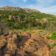
read moreWild, rugged, and weathered — the Wichita Mountains Wildlife Refuge in central Oklahoma is a symbol of the old west standing at the threshold of modern times. The natural attractions of the refuge are many and varied. In addition to viewing and photographing wildlife in their natural setting, visitors find the lakes, streams, canyons, mountains and grasslands ideal for hiking, fishing, and other outdoor activities. Elk Mountain lies within the Charons Garden Wilderness Area in the western corner of the refuge. You may not think of...
read moreThe Puebloan people have lived in the American Southwest for many centuries. Archaeologists think they are descended from groups of hunters and gatherers who came to the region over 10,000 years ago. In the area that is now Bandelier National Monument, in Northern New Mexico, the villages of Tyuonyi and Tsankawi and their adjacent cliff dwellings appeared in the 13th century AD. Handsome Pueblo revival-style structures and Civilian Conservation Corps trails now serve the park, enabling visitors to discover the history and culture of the...
read moreThe labyrinth called Canyon de Chelly (pronounced d’SHAY) comprises several canyons that include Canyon de Chelly, Monument Canyon and Canyon del Muerto. At the mouth of the canyons near the tribal town of Chinle, in northeastern Arizona, the rock walls are only 30 feet high. Deeper in, the bright red sandstone bluffs rise dramatically to stand more than a thousand feet above the sandy floor. Sheer cliffs overshadow streams, cottonwood trees, and small, culturally significant ancestral farms below. The Canyon de Chelly National Monument...
read moreIsland in the Sky is a thousand foot high mesa in the isthmus between the Green and Colorado Rivers that forms one of Canyonlands National Park’s four distinct districts. There is excellent hiking on each side of the mesa, including this trail on the west side that circumnavigates Upheaval Dome. Once thought to be a collapsed salt dome, new geologic evidence appears to indicate an impact crater — either from a comet or meteor. This quite strenuous trek will test your mettle as you scramble up ledges, clamber over boulders and...
read moreMost folks who visit Colorado National Monument view its red sandstone landmarks from Rim Rock Drive and its many overlooks. It’s convenient for peering deep into the canyons. However, like most places of interest, getting out of your car and putting your boots on the trail will give you an up-close-and-personal encounter with iconic features like Independence Monument, the Saddlehorn, Pipe Organ, and the Kissing Couple. This 5-mile loop up Wedding Canyon, then back down Monument Canyon is a good introduction to ground level Colorado...
read moreSometimes your hiking plans just don’t work out. That happened when our plans were kiboshed by a closed and padlocked gate. They say when the world gives you lemons, go take photographs, or something like that. There isn’t much more beautiful in Spring than Lake Lure and Chimney Rock State Park. Morse Park on Lake Lure features beautiful vistas of the mountains of Hickory Nut Gorge and is a popular choice for an impromptu picnic, sunbathing, reading, bird watching or catching an afternoon nap in a lawn chair by the lake. Only...
read moreThe Cradle of Forestry along Scenic Forest Byway 276 in Pisgah Ranger District is the birthplace of forest conservation in America. Spanning over 100 years of forest conservation history, the Cradle offers a snapshot of life at America’s first School of Forestry along the Biltmore Campus Trail. German forester Dr. Carl A. Schenck accepted George Vanderbilt’s offer to come to North Carolina to transform the woodlands we know today as Pisgah National Forest. To insure the forest would remain enticing, Schenck established the forestry school to...
read moreYou know how some hikes can be kinda boring, then have a big reward like an outstanding overlook at the end? Or perhaps others will wind through a stunning forest only to peter out? Well, this hike located in the Greenbrier section of the Smokies has neither problem. The Porters Creek Trail is an exciting adventure from start to finish. I would describe it as a play with four acts. The opening act follows a picturesque, cascading mountain stream. Act II is all about history — including farmsteads, a cemetery, and recreations of a 19th...
read moreThere are lots of little maintenance trails alongside the Blue Ridge Parkway that don’t show up on any trail maps or have any signs to let you know they are there. One of those is a hidden gem in the high country at milepost 420 directly across from the Black Balsam spur road. It’s great for an hour stroll to brighten you senses, or if you’re looking for a quiet and peaceful spot for lunch away from the madness of Graveyard Fields. With magnificent views of Pilot Mountain and Black Balsam and Mt. Pisgah, you will get a...
read moreVenturing more into the central part of Tennessee to the Cumberland Plateau has been a goal of mine for some time. The name “Walls of Jericho” kept cropping up, so that clinched the destination. So what is this hike with the biblical name? The place known as the Walls of Jericho is a narrow canyon, about a half-mile long, with 200-foot-high vertical limestone bluffs on each side. Exploring the headwaters of the Paint Rock River, this demanding trek straddles the Tennessee-Alabama state line as it delves deep into the gorge. The...
read moreLocated on the Tims Ford Reservoir, the 2,200-acre Tims Ford State Rustic Park sits in the shadows of the Cumberland Plateau in south-central Tennessee. There are 6.5 miles of unpaved hiking trails found within the park, in addition to 22 miles of bike trails that may also be used for hiking. Two of the three hiking trails begin at the park Visitor Center, while the third wraps the shoreline near the park marina. Combining the Lost Creek and Marble Plains trails makes a nice loop along a portion of the lakeshore that is nearly three miles in...
read moreThere are only two trails in all of Great Smoky Mountains National Park where you can ride your bike or walk your dog. The Oconaluftee River Trail near Cherokee, NC is one of them. Starting at the Oconaluftee Visitor Center, this easy 3-mile round trip is a stroll along the river, and through history. You pass by the Mountain Farm Museum, a collection of 19th century wooden structures that were restored here from locations all over the national park. You’re likely to see anglers in the river, maybe even elk in the meadows as you walk...
read moreExactly what the name implies, Big Creek in the Smokies is larger than some rivers in the area. Add in a 70° day after a couple snow events and Big Creek will really roar. When Big Creek roars, that brings out the kayakers, so there was even more of a show than just the scenery. Big Creek Trail is an old logging road that follows the creek westward beneath the Cammerer and Mount Sterling Ridges. There are two featured waterfalls along the way: Midnight Hole and Mouse Creek. Beautiful spring-like weather and scenery, rapid whitewater and...
read moreWhen bitter cold winter temps come around, perhaps the last thing on your mind is hiking. I get that. I’m no fan of the cold either. As with everything else though, Mother Nature has a reward if you are willing to tolerate the temporary discomfort. Frozen waterfalls! It’s a rare occurrence in Western North Carolina, but usually once a year, the air will stay cold enough, long enough, to freeze some of the waterfalls in Pisgah National Forest. There are several that don’t even require much of a walk to get to. So on a cold...
read moreSurrounded on three sides by Cherokee National Forest, Tennessee’s Martha Sundquist State Forest is the only one in the state forest system with a dedicated hiking trail. The Tennessee Gulf Trail (named for a former owner of the property, Lambs Gulf Company) follows Brown Gap Creek from the northwestern to the southeastern corners of this 2,000 acre cove hardwood forest. Martha Sundquist, an outdoors enthusiast and former First Lady of Tennessee, suggested that the state forest bearing her name include a footpath for hikers. We’re...
read moreSometimes the forest roads in national forests make the best hiking trails. Such is the case with FR 5031 in Pisgah National Forest. Located near Courthouse Falls on the far southwestern side of Pisgah, near the boundary with Nantahala National Forest, FR 5031 is a means of getting from a drainage bowl to Farlow Gap on Shuck Ridge. For mountain bikers, you could connect at the gap with the Daniel Ridge Loop. For hikers, it’s a delightful grassy gambol through new growth hardwood, past mammoth rocky outcroppings and across several...
read moreEven though Devils Elbow is a mountain summit, the highlights of the Devils Elbow Trail in Panthertown are the myriad of waterfalls on the Tuckasegee River. The river forms at the confluence of Panthertown and Greenland Creeks, then takes a wild ride over several falls on its way eventually to Fontana Lake in the Great Smoky Mountains. Most of this hike is on maintained trail, but prepare yourself to do battle with rhododendron thickets on your way to each waterfall. When the leaves are down, there are scattered views from the Devils Elbow...
read moreThe Greenbrier section of Great Smoky Mountains National Park is filled with old growth forest, and with lots and lots of creeks draining into the valley from the high mountains of the Smokies above. The path of one of those creeks, False Gap Prong, takes it from near Laurel Top to Greenbrier Cove. A non-supported trail — otherwise known as a manway — follows False Gap Prong for a few miles past ruins of century-old homesteads and moss covered boundary walls. There’s a stand of giant tulip poplars up there, including one...
read moreFor a scenic stroll along a horse path through the South Mountains forest, you may give Little River Trail a try. Starting at the Cicero Branch parking area and climbing above Jacob Fork gorge, you will pass viewpoints for the North Carolina Piedmont and follow Little River to the end of the trail at a small but treacherous hidden waterfall. I hiked to Little River Falls on Saturday, December 27, 2014 between 2:00PM and 4:00PM. Since this was my first visit to South Mountains State Park, I was just out exploring. My plan was to see what I...
read moreNorth Carolina’s South Mountains State Park has more than 45 miles of marked trails. No doubt the most popular is the High Shoals Falls Loop Trail, a short, but tough climb to an 80-foot crystal-clear free-fall. Travel for a mile along rocky Jacob Fork River before beginning the steep ascent that requires stairs to navigate the tough terrain. From a viewing platform for High Shoals Falls, the trail continues climbing to the top of the falls, before looping down through the forest. In winter, you will also enjoy long distance views...
read moreBlue Ridge Pastures is a grassy knoll northwest of Bearwallow Mountain along the Buncombe/Henderson County line. With terrific views of Hickory Nut Gorge, and on clear days The Great Craggy and Black Mountains, the reward for your hard work pays off. The Trombatore Trail will make you climb twice for your reward, once before and once after, but keep that reward in mind as you trod along this brand new 2014 addition to the Hickory Nut trail system. The trail passes through the Upper Brush Creek watershed and along the Eastern Continental...
read moreThis section of the Palmetto Trail borders the Poinsett Watershed used by the City of Greenville, and roughly follows the North/South Carolina state line. Enjoy a delightful forest hike that winds among the Saluda Mountains as you’re passing through one of the most significant wilderness areas in South Carolina. In 1993, the Greenville Water System conveyed an easement on the property to The Nature Conservancy, forever protecting the wilderness from development. The South Carolina Upstate passages of the Palmetto Trail haven’t yet...
read moreThis climb up Station Mountain begins within Oconee Station State Historic Site then passes through Sumter National Forest on the way to Oconee State Park. Along the way you’ll enjoy the 60-foot Station Cove Falls and a botanical preserve inhabited by beaver. The climb is a good workout, as a peaceful hardwood forest and a well-maintained trail lined with switch cane surround you. This is the western end of the Palmetto Trail, a long distance track that passes from the “Dark Corner” of South Carolina all the way to the...
read more I am Jeff Clark, founder of Internet Brothers, producer of this blog, and passionate about hiking. I live in Western NC near the Blue Ridge and Great Smoky Mountains. Pisgah and Nantahala National Forests are just out my door, so the content will focus on these areas, but let me know what you would like to see on the site.


Copyright © 2011-2023 Internet Brothers. All Rights Reserved. ISSN 2324-6057
Designed by Elegant Themes | Powered by Wordpress | Logo by Design Aspirations