Perhaps the most popular feature in all of Great Smoky Mountains National Park, Cades Cove is a throwback to 19th century living. Think of it as an outdoor museum. Cades Cove is a wide, verdant valley surrounded by mountains that today is teeming with wildlife and spring floral beauty. The 11-mile Loop Road around the valley provides an opportunity for motorists, bicyclists, even walkers like me to sight-see at a leisurely pace. Cades Cove offers the widest variety of historic buildings of any area in the national park, including churches,...
read moreWithout a doubt one of the most popular wildflower hikes on the Tennessee side of Great Smoky Mountains National Park, Whiteoak Sink is a basin surrounded by steep hills. In April each year this natural botanical garden comes alive with more than 30 varieties of native wildflowers right alongside the trail for all to enjoy. The name “Sink” comes from the caves that are found in the area, really more like rocky sinkholes. Much like Cades Cove just a few miles to the west, Whiteoak Sink was settled in the 19th century long before...
read moreThis lovely wildflower trail is about half way up Newfound Gap Road from the Oconaluftee Visitor Center, but its shortish length and tranquil setting belie the grueling terrain. Climbing from the Oconaluftee River valley to Thomas Divide, 2,200 feet above, it is a true test of stamina for even the most seasoned hikers. Kanati Fork is one of those picturesque drainages seemingly found everywhere in the Smokies. The mountains and water give the land its character. The abundant wildflowers along this trail are simply an extra added bonus. I...
read moreThe Smokies can always be counted on for fulfilling the promise of spring renewal. One of the best spots for finding early blooms of exotic native wildflowers is on Porters Creek Trail in the Greenbrier section of the national park. Along the pathway is a diverse array of flowery goodness including the multi-acre mystical fringed phacelia garden, seemingly home to a host of woodland creatures like sprites and faeries. The dazzling display of Mother Nature’s finest has been a couple weeks early this year, due in large part to a very warm...
read moreNamed for an opportunistic traitor who supported the Crown during the Revolutionary War, Paris Mountain State Park was constructed by the Civilian Conservation Corps during the Great Depression. Richard Pearis owned 150,000 acres including what is now Greenville, SC and this state park north of the city. Once no more than a rural retreat, Paris Mountain is now a bustling destination for hikers and mountain bikers who test their conditioning on the park’s mature trail system. In addition to the near 15-mile trail infrastructure, there is...
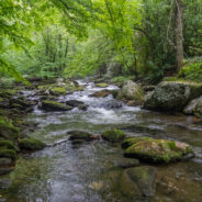
read moreWhat is the first thing that comes to your mind when you think of the Smokies? Is it 6,000 foot mountaintop vistas that expand the imagination? Perhaps you think of the half-million acres of forest or the hundreds of varieties of wildflowers. There is one other constant in Great Smoky Mountains National Park, and that is water. Cataloochee Valley is surrounded on all sides by myriad creeks and streams that tumble down from those tall mountaintops. Among them is Palmer Creek, named for a 19th century settler. Pretty Hollow Gap Trail and Palmer...
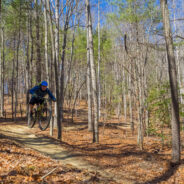
read moreWhen you step on a trail at DuPont State Forest, you can usually tell pretty quickly if it was designed and built for mountain biking. Some tell-tale signs are banked curves and bumps, rails for tricks, and a smooth, hard-packed surface. Such is the case with Ridgeline Trail. DuPont State Forest is a haven for mountain bikers from all over the Southeastern United States, and Ridgeline Trail is one of their favorites. Hey, equestrians like it too. Combine it with a loop around and over Hickory Mountain for a nice hike, or an exciting ride. I...
read moreThe Appalachian Trail splits the states of North Carolina and Tennessee through most of the breadth of Great Smoky Mountains National Park. Hugging the state line as it traverses the rugged and remote ridges, the AT is a favorite destination for day hikers and thru hikers alike. There is a three and a half mile stretch from Newfound Gap to the summit of Mt. Kephart, and beyond to a magnificent overlook known simply as The Jumpoff, that provides an excellent example of what high country Smoky Mountains terrain is all about. I’ve written...
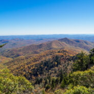
read moreThomas Divide is one of those ridge hikes that splits the heart of the Great Smoky Mountains Range. It is also one of the longer trails in the national park at near 14 miles, but you can do as much or as little as you wish for a day hike. The trail passes through a rich forest of Eastern hemlock, beech, birch and multiple varieties of maple. The crest also enjoys the presence of spruce and fir. When the leaves are down you can see Clingmans Dome on the west side of the ridge and the massive shoulders of Richland Mountain to the east. Ken and...
read moreWalking the Blue Ridge Parkway in winter is a great way to get a slow-motion view of the wonderful vistas that whiz by at 45 mph in your car. The Parkway is closed so you don’t have to worry about traffic. The only concern really is perhaps slipping on snow or ice. This latest in the Photo Essay series looks at a 4-mile stretch of the BRP between mileposts 412 and 408. It starts where Scenic Hwy 276 climbs to meet the Parkway at milepost 412. The Cold Mountain Overlook is right there, and that’s where Ken and I parked. Gates are...
read moreWorking on a little project to tick off all the trails within DuPont State Forest, I visited two short ones that are close to each other in the northeast corner off Sky Valley Road. Each is little more than a mile round trip. Flat Rock Trail passes through a boulder field and past a recent logging operation to a dead end at the confluence of Jim Creek with Grassy Creek. Plantation Trail walks among an absolutely stunning pine forest that, judging by all the ribbons tied to trunks, is unfortunately probably next for the lumberjack’s axe....
read moreLocated in the heart of DuPont State Forest, Three Lakes Trail does exactly what its name implies… it takes you to a trio of very picturesque lakes near Conservation Road. Lake Dense is an ideal stop for a family picnic. Lake Alford, really more of a pond, may be the most vivid and charming of all. The largest, Lake Julia, is breathtaking from every angle. Add to this a stroll along Pitch Pine Trail to reach the lakes, and a visit to Bridal Overlook afterward, and you can make a delightful day in the woods of DuPont State Forest. I...
read moreArriving before the morning sun had a chance to melt the fresh dusting of snow, I walked this short loop in the southwest corner of DuPont State Forest with the sound of woodpeckers filling the air… and not much else. It was quiet. A half inch of snowfall muted the normal sounds. I purposely picked this woodsy loop. Usually enjoyed by mountain bikers, I guessed correctly that I would have it all to myself on this day. So for two serene hours I strolled along Pine Tree and Cascade trails following rabbit and squirrel tracks and listening...
read moreBryson City, NC is located on the far southern boundary of Great Smoky Mountains National Park and hosts the Deep Creek and Lakeview regions of the park. Noland Creek Trail runs north/south off Lakeview Drive between Fontana Lake and the Noland Divide high above in the mountains. The trailhead is one mile north of the lake and heads in both directions. On this day Ken and I headed north up into the drainage. The Noland Creek valley contains a beautiful hardwood and pine forest and at one time was home to several settler families. If you look...
read moreJones Gap State Park sits on the Blue Ridge Escarpment in upstate South Carolina very near the state line with its neighbor to the north. Along with Caesars Head State Park, these two share an area known as Mountain Bridge Wilderness. The Jones Gap Trail follows the Middle Saluda River along an old roadway built by Solomon Jones in the 1850s. In this cove backcountry the river is quite wild with many waterfalls and rapids that add exciting sights and sounds to a pristine mountain woodland. Near the eastern end of Jones Gap Trail are two...
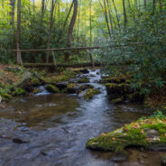
read moreThe Smokemont region of the Smokies is one of the most convenient, located just a short few miles northwest of the Oconaluftee Visitor Center off Hwy 441. The trailhead for Bradley Fork starts in the back of the Smokemont Campground, surrounded by the Smokies ubiquitous waterways. It’s only a mile and change up Bradley Fork Trail to its meeting with Chasteen Creek Trail, and then just another three-quarters mile to an exciting cascade on Chasteen Creek. The path along the way is easy to navigate and offers many picturesque vantage...
read moreAugust 2005 saw the Carolina Mountain Land Conservancy and The Nature Conservancy purchase a 1,568-acre tract of land south of Lake Lure known as “World’s Edge” for $16 million with the intention of transferring the land as the first to be added to the new Chimney Rock State Park. World’s Edge contains a mile-long set of steep slopes on the eastern edge of the Blue Ridge Escarpment, with more than 20,000 feet of streams and waterfalls. From an overlook point, the land falls away to the southeast providing a stunning view of...
read moreThe far southwestern corner of DuPont State Forest offers a forested hike atop multiple plutons, past a retired rock quarry, and across a couple of gentle mountain streams. The oak trees are in abundance, as are white and longleaf pines. Look for the fascinating moss and reindeer lichen on the plutons as you gaze at the far away mountains of Pisgah National Forest. This section of the state forest is quite popular with mountain bikers, but hikers can enjoy the scenery every bit as much. Ken and I explored the Micajah on Wednesday, December...
read moreBeginning at the Guion Farm area of DuPont State Forest on Sky Valley Road you can make a nice hike on several roads that loop through a deep and dense pine woodland. This is a pine regrowth region that the N.C. Forest Service leases for controlled logging, so you may need to keep your eye out for large trucks, but you may also have the opportunity to see modern lumberjacks in action. Half way along the loop through the forest is a 19th century cemetery that encloses the remains of the Thomas family. Dave, Grace and I walked these roads on...
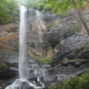
read moreMatthews Creek plunges more than 350 feet over Raven Cliff Falls into the gorge it has carved below Raven Cliff Mountain. One of a myriad of landmarks along the Blue Ridge Escarpment in Caesars Head State Park, the rim of this gorge offers a gentle and rewarding hike. Part of the Mountain Bridge Wilderness Area that also includes Jones Gap State Park, this is the most extensive trail system in South Carolina. More like Western North Carolina than the coastal and central regions, the South Carolina Upcountry is similar in elevation and forest...
read moreHistoric Asbury Trail straddles the boundary between the Smokies national park and the Appalachian Ranger District of Pisgah National Forest. It is named for Methodist Bishop Francis Asbury who, in the early 19th century, brought his traveling ministry to this area that would eventually become a national park more than a hundred years later. It was also formerly known as the old Cattalucha Indian track. You can follow Asbury Trail past the gauging station on Cataloochee Creek and all the way to Scottish Mountain, 12 miles from the Cove Creek...
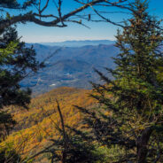
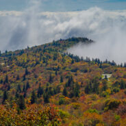
read moreSometimes things just don’t go exactly as planned. But making the most of what’s available is what sets hiking apart. Everything doesn’t have to go perfectly to still enjoy the day. Such was the case with this hike across the Plott Balsams mountain range from Waterrock Knob on the Blue Ridge Parkway. You’re in rarefied air here, with the entire trail above 5,600 feet, and with magnificent views of the Great Smoky Mountains, the thriving mountain community of Sylva, NC, and even all the way to Mt. Pisgah far to the...
read moreLooking for a short, easy, serene getaway in the high country that offers outstanding long distance views of the Blue Ridge Mountains? This is the trail for you. This little stretch of the famous Mountains to Sea Trail will take you from Black Balsam Road, through a dark and deep balsam spruce forest, across Silvermine Bald and on to Chestnut Bald to a splendid overlook of Looking Glass Rock, Pilot Mountain, and Pisgah National Forest’s Cradle of Forestry. If you have your binoculars or a zoom lens, you can see all the way to Lake...
read moreLocated in the far southern region of the Smokies, near Fontana Village and the Little Tennessee River, Twentymile is an area of the national park that is a little less traveled. Primarily used by backpackers as a means of accessing remote park highlights like Gregory Bald or Shuckstack Fire Tower on the Appalachian Trail, Twentymile can also be enjoyed by day hikers or creek seekers year round. Like so much of the mountainous Smokies, Twentymile is blessed with water, water everywhere. Two-thirds of the length of this loop is alongside...
read moreLeaf peepers head to Graveyard Fields in late September for the annual ritual of Autumn color in the high country. Located at mile 418 on the Blue Ridge Parkway, Graveyard Fields is one of the earliest locations to begin the chromatic display, as well as one of the most intense. From the bright red of the blueberry and sumac bushes, to the multi-colored hues of the maple and oak, this is a prime location year in and year out. But don’t limit yourself to Graveyard Fields. There is a 5-mile stretch of the Parkway from mile 416 through...
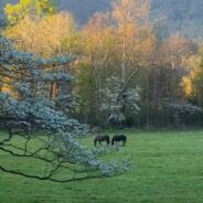
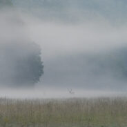
read moreLate September is an exciting time in Cataloochee Valley as the elk herd begins their annual mating dance ritual known as the rut. Cows, calves and yearlings live in loose herds or groups throughout most of the year, and are seen wandering the vast meadows of the valley all spring and summer. The bulls, however, live in bachelor groups or alone. It is rare to happen upon a bull off season. During the rut, cows and calves form harems with one or two mature bulls. At this time of early fall, people come from far and wide to this corner of the...
read moreJoyce Kilmer-Slickrock Wilderness straddles the North Carolina / Tennessee line near the southern borders of the states, with about 75% of its 17,000 acres contained in NC. Six trailheads provide access to more than 60 miles of trail within the designated wilderness, which typically follow ridge tops or drop into the shady drainages. Perhaps the most atypical trail though is the Slickrock Creek Trail to Lower Falls in the far northern corner of the wilderness. A series of dams on the Little Tennessee River nearly a hundred years ago created...
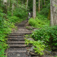
read moreChimney Tops is one of the more popular destinations in the Smokies because of its central location, rugged beauty, and challenging access. And challenging it is. While short in distance, the trails that lead to the summit of Chimney Tops are steep and strenuous. Accessible from two trails, one below that climbs from Hwy 441 to the top, and one above that drops down from Clingmans Dome Road to meet the other. It was this latter, known as Road Prong Trail and formerly Indian Gap Road, that we chose for our adventure to Chimney Tops. We...
read moreGrand Highlands is a real estate development in Henderson County, NC. What sets it apart is location. A location that is described as “an open meadow placed on a mountaintop.” Land that affords you some of the most spectacular views in Western North Carolina. I think of it as a picturesque spot for taking photographs of the surrounding Blue Ridge Mountains and valleys. Within a stone’s throw of two delightful hiking trails that were built and maintained by the Carolina Mountain Land Conservancy, Grand Highlands is also a launch point...
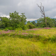
read moreDeep in the remote southwestern corner of North Carolina where the scenic Cherohala Skyway climbs to meet Tennessee at Beech Gap, the Bob Bald Connector Trail (54A) climbs a ridge through Nantahala National Forest to Bob Stratton Bald. One of the lush mountaintop meadows the Southern Appalachians are known for, Bob Bald as it is called, straddles a boundary between Citico Creek Wilderness and Joyce Kilmer-Slickrock Wilderness. During the green seasons Bob puts on a dazzling display of wildflowers with a remarkable array of colors that rival...
read more I am Jeff Clark, founder of Internet Brothers, producer of this blog, and passionate about hiking. I live in Western NC near the Blue Ridge and Great Smoky Mountains. Pisgah and Nantahala National Forests are just out my door, so the content will focus on these areas, but let me know what you would like to see on the site.


Copyright © 2011-2023 Internet Brothers. All Rights Reserved. ISSN 2324-6057
Designed by Elegant Themes | Powered by Wordpress | Logo by Design Aspirations