
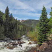
This trail climbs from East Vail into Eagles Nest Wilderness alongside Gore Creek. There are some short steep sections that wind through meadows and aspen groves which change to spruce-fir stands as the elevation increases. Also look for a wide variety of wildflowers in season. Particularly during spring runoff, Gore Creek rages down the drainage with its series of fast...
Learn More
Were you to hike nearly nine miles into a wilderness area, paralleling a creek through alpine meadows and woods, you might expect to find solitude. But that’s not the case at Conundrum Hot Springs, an extremely popular area of natural pools at an elevation of over 11,000 feet with views of surrounding peaks in White River National Forest, Colorado. Dozens — and on busy...
Learn More
This trail follows the McCullough Creek drainage up the gulch beneath the massive summit of 14,225′ Quandary Peak. It starts on an old mining road south of Breckenridge, CO, then changes to single track trail as it climbs the gulch. You’ll pass through pine and fir forest, get splashed by White Falls, marvel at the colorful granite, and count the variety of...
Learn More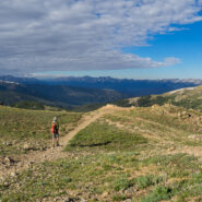
The easier of the trails at Loveland Pass, West Ridge surrounds two sides of the bowl that makes up the Loveland area and the I-70 corridor over the Continental Divide. Still, at 11,990 feet, this is no piece of cake for folks like me who are used to mountains no more than half the elevation. Several ski slopes are visible from the ridge. Look too for cute rodents to...
Learn More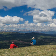
This marvelous example of Rocky Mountain vistas starts, oddly enough, directly beside Interstate-70 at Colorado’s 10,585′ Vail Pass. The trail winds through forest and meadow, then climbs steeply above treeline to Uneva Ridge, 1,500 feet above. Along the way you will enjoy breathtaking views of four distinct mountain ranges as you pass into Eagles Nest...
Learn More
Highway 4, west out of Leadville, CO offers a driving adventure that takes you past lakes, among a various assortment of summer wildflowers, and over a high mountain pass that tops out just short of 12,000 feet. I needed the drive rather than hiking the first day after recovering from a newly discovered adult-onset allergy to cashew nuts. The annual visit with my brother...
Learn More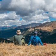
There’s a reason they call it Summit County. An old mining road climbs from Hoosier Pass above 12,000 feet and is surrounded by several of Colorado’s famous fourteeners. The first half of the road meanders through a spruce and fir forest with occasional views of the massive mountains that envelop the region. The rest of the way is above treeline, offering...
Learn More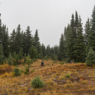
Fog and low-lying mist is very common in the Southern Appalachians. It is a product of the rainforest effect. Fog is highly unusual in the Rocky Mountains, but that’s what greeted Dave and I as we hit the trailhead to climb Shrine Ridge. It was somewhat of a dreary, forlorn scene as we walked from mountain bog to spruce forest to high meadow on our way to the...
Learn More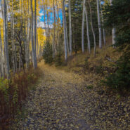
The U.S. Forest Service has done a nice job of building trails up the watersheds that drain into the Town of Vail. Included among these is Spraddle Creek, located across I-70 from Vail Village. The reward at the top of the ridge is a mountain meadow that overlooks Vail, Beaver Creek ski mountain, and the Holy Cross Wilderness far, far away. Hike in late September for an...
Learn MoreA much-anticipated Bureau of Land Management decision to move forward with plans to cancel 25 previously issued but never-developed oil and gas leases in the Thompson Divide region met with the usual praise from conservation groups and industry criticism. The BLM formally released its final environmental impact statement for its review of 65 existing leases on the White...
Learn More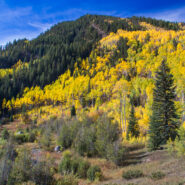
I went to the Colorado Rockies in late September-early October with the expressed intention of being there for the autumnal yellowing of the aspen trees. It’s a gorgeous sight, the leaves take on a golden glow that shimmers in the breeze. Well, mission accomplished. My brother saved East Lake Creek Trail for the last hike of my visit, one that walks for miles in...
Learn More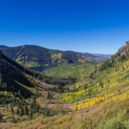
Beginning on Columbine Dr. in East Vail, CO, the Bighorn Trail climbs steeply out of the Vail Valley, then more gradually climbs up through stands of aspen and pine. The trail passes beaver ponds and the remains of old mining camps as well as Bighorn Creek. Near the halfway point, be sure to turn around because the views of Vail and Bighorn drainage behind you are...
Learn More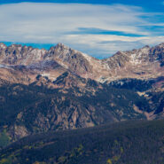
Bowman’s Shortcut is an easy-to-get-to trail that tops a ridge that enables views of three different mountain ranges — Sawatch, Gore, and Tenmile. You’ll start out climbing through a pine forest with occasional glimpses of the distant peaks through the trees, then reach the bald ridge and the magnificent views of some of Colorado’s highest...
Learn More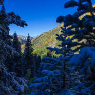
Booth Lake Trail begins at Booth Falls Road in East Vail, CO and ends at Booth Lake. The trail climbs up the Booth Creek valley through mostly aspen groves before passing the 60-foot Booth Falls. Beyond the falls the trail winds through conifer forests and meadows filled with wildflowers. Above 10,000 feet the trees thin and the terrain changes offering views of the Gore...
Learn More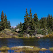
One of the things I miss about the Blue Ridge and Smokies is mountain lakes. The Rocky Mountains are adorned with memorable alpine lakes, usually surrounded by majestic peaks and bountiful evergreen forest. All you need is an input and output source, like Fall Creek in the case of Lake Constantine, and a bowl between mountains to collect the water. Fall Creek Trail...
Learn More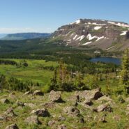
Flat Tops Wilderness is the second largest U.S. Wilderness Area in Colorado. Located near the towns of Yampa and Steamboat Springs, it is 235,214 acres, with 38,870 acres in Routt National Forest and 196,344 acres in White River National Forest. The area is named for a series of flat top mountains that dominate the landscape. This is sub-alpine and alpine terrain with...
Learn More I am Jeff Clark, founder of Internet Brothers, producer of this blog, and passionate about hiking. I live in Western NC near the Blue Ridge and Great Smoky Mountains. Pisgah and Nantahala National Forests are just out my door, so the content will focus on these areas, but let me know what you would like to see on the site.


Copyright © 2011-2023 Internet Brothers. All Rights Reserved. ISSN 2324-6057
Designed by Elegant Themes | Powered by Wordpress | Logo by Design Aspirations