
On Oct. 21, 2014 the U.S. Forest Service unveiled draft management area boundaries that put 692,700 acres — about 69 percent — of Nantahala-Pisgah National Forest in management areas that make “timber production, for the purposeful growing and harvesting of crops of trees to be cut into logs” the “primary or secondary use of the land.” Today, the Nantahala-Pisgah is one...
Learn MoreThe US Forest Service today announced that Ball Creek Road (NFSR 83), located in Macon County, NC on the Nantahala Ranger District of the Nantahala National Forest, will be temporarily closed for its entire length from approx. September 29th, 2014 until late October, depending on the duration of the road work. Ball Creek Road begins at Coweeta Hydrologic Laboratory and...
Learn More
Researcher, Conservationist & Bushwhacker Dave Landreth is an outspoken Southern Appalachian conservation advocate who, through years of researching wildlife in the Northern Rocky Mountains of Wyoming, has developed a passion for protecting clean air and water, public lands and the plants and animals that live among us. His penchant for collecting plaster...
Learn More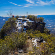
Pinnacle Park is an 1,100 acre tract of land owned by the town of Sylva in Jackson County, NC that was previously used as the community watershed. In 1991 it was leased to the Pinnacle Park Foundation for developing hiking trails that pass by streams, waterfalls, and beautiful long distance vistas. The Pinnacle, where the park got its name, is a large rocky outcropping...
Learn More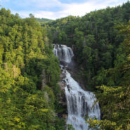
Transylvania County, North Carolina is known as “Land of Waterfalls” for good reason, as there are 250 unique cascades within a short drive of each other. Upper Whitewater Falls on the Whitewater River south of Sapphire is perhaps the most spectacular. There are two distinct overlooks of the 411 foot plunge taken by the river on its path to Lake Jocassee....
Learn More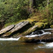
Designated a National Wild and Scenic River, the Chattooga River’s headwaters are in North Carolina, but it stretches into Georgia and South Carolina as well. In fact, at one point known as Ellicott Rock, it marks the common tri-boundary of all three states. There are more than 50 miles of trails along the Chattooga River but this four-mile stretch just south of...
Learn More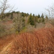
The Mountains to Sea Trail spans the width of North Carolina, running from the Great Smoky Mountains in the west, to the Outer Banks of Coastal Carolina. Much of the trail in the mountainous part of the state is near or parallels the Blue Ridge Parkway. This section of the MST along the parkway has been designated a National Recreation Trail. With elevations well above...
Learn More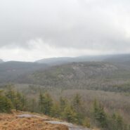
Situated in the far northern reaches of the Panthertown Trail System in Nantahala National Forest, Turkey Knob and Blackrock Mountain offer long distance views of the more well known features of Panthertown Valley. From more than 4000 feet elevation, there are splendid views of Little and Big Green Mountains and The Great Wall. The full expanse of Mac’s Gap lays on...
Learn More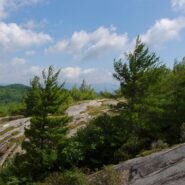
This is an extension of the trail report about the Panthertown Trail System in Nantahala National Forest from a previous post. When we explored Panthertown last November, we knew very little about it and kind of fumbled our way along the myriad of trails. Since, we have studied the trail system map and had a plan that included going to the top of Big Green Mountain, a...
Learn More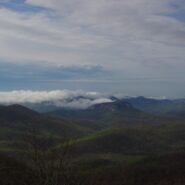
Frequently. That is how many times I have done this hike. So many, I’ve lost count. I love the western North Carolina high country, and this area along the Blue Ridge Parkway known as Black Balsam has nearly a dozen peaks over 5,800 feet elevation, with Black Balsam Knob being the highest at 6,214. This area has some of the highest hiking on the Parkway. Many of...
Learn More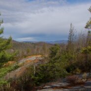
Panthertown Valley lies in Nantahala National Forest near Cashiers and Lake Toxaway, North Carolina. The Forest Service, along with the Friends of Panthertown, have created a trail system in combination with old logging roads that lead to waterfalls, cliffs, bogs, deep forest and spectacular overlooks of the surrounding valley. Panthertown has been designated a Blue...
Learn More
This hike is in one of my favorite areas of Pisgah National Forest along the Blue Ridge Parkway in western North Carolina. It lies in a little corner between Middle Prong Wilderness and Shining Rock Wilderness where the mountain tops are bald and exceed 6000′. This hike occurred on March 24, 2011 beginning at 10:00AM and ending about 3:00PM. The goal on this day...
Learn More I am Jeff Clark, founder of Internet Brothers, producer of this blog, and passionate about hiking. I live in Western NC near the Blue Ridge and Great Smoky Mountains. Pisgah and Nantahala National Forests are just out my door, so the content will focus on these areas, but let me know what you would like to see on the site.


Copyright © 2011-2023 Internet Brothers. All Rights Reserved. ISSN 2324-6057
Designed by Elegant Themes | Powered by Wordpress | Logo by Design Aspirations